
SEPTEMBER 2018 - Very Wet Month Wrap Up
-
srainhoutx

- Site Admin

- Posts: 19700
- Joined: Tue Feb 02, 2010 2:32 pm
- Location: Maggie Valley, NC
- Contact:
Flash Flood Watch that was due to drop at 7 AM tomorrow morning has been extended until at least Noon tomorrow. Favorable jet streak across New Mexico and West/North Texas and a favorable atmospheric wind pattern suggests redevelopment of storms overnight into tomorrow morning. The $64,000 question is the greatest threat along the Coast or further inland along the I-10 Corridor? Time will tell as the meso models are struggling with this pattern.
Carla/Alicia/Jerry(In The Eye)/Michelle/Charley/Ivan/Dennis/Katrina/Rita/Wilma/Humberto/Ike/Harvey
Member: National Weather Association
Facebook.com/Weather Infinity
Twitter @WeatherInfinity
Member: National Weather Association
Facebook.com/Weather Infinity
Twitter @WeatherInfinity
-
BlueJay
- Posts: 938
- Joined: Tue Mar 04, 2014 10:47 am
- Location: Alden Bridge-The Woodlands, Texas
- Contact:
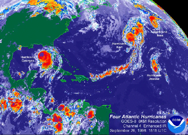
srainhoutx wrote:And for those wondering, the last time there were 4 Hurricanes in the Atlantic Basin at one time was 1893.
-
Scott747
- Posts: 1648
- Joined: Tue Feb 23, 2010 9:56 am
- Location: Freeport/Surfside Beach
- Contact:
It's a reach but the 18z gfs is ever so slightly a little more defined. Nothing really organized but could finally be trending that way.
The disturbance gets a mention in the Flo disco with the idea that ridging to the N may not be as strong.
The disturbance gets a mention in the Flo disco with the idea that ridging to the N may not be as strong.
-
unome
- Posts: 3062
- Joined: Fri Feb 12, 2010 6:11 pm
1998: Georges, Ivan, Karl, Jeanne https://weather.com/storms/hurricane/ne ... n-20130925BlueJay wrote:srainhoutx wrote:And for those wondering, the last time there were 4 Hurricanes in the Atlantic Basin at one time was 1893.WOW! We are living through some very historic days lately...
-
DoctorMu

- Posts: 8048
- Joined: Sun Jun 28, 2015 11:58 am
- Location: College Station
- Contact:

-
DoctorMu
- Posts: 8048
- Joined: Sun Jun 28, 2015 11:58 am
- Location: College Station
- Contact:
unome wrote:1998: Georges, Ivan, Karl, Jeanne https://weather.com/storms/hurricane/ne ... n-20130925BlueJay wrote:srainhoutx wrote:And for those wondering, the last time there were 4 Hurricanes in the Atlantic Basin at one time was 1893.
Ivan lasted 23 days and struck the US twice!
-
srainhoutx
- Site Admin
- Posts: 19700
- Joined: Tue Feb 02, 2010 2:32 pm
- Location: Maggie Valley, NC
- Contact:
TROPICAL WEATHER OUTLOOK
NWS NATIONAL HURRICANE CENTER MIAMI FL
800 PM EDT MON SEP 10 2018
FOR THE NORTH ATLANTIC...CARIBBEAN SEA AND THE GULF OF MEXICO:
THE NATIONAL HURRICANE CENTER IS ISSUING ADVISORIES ON HURRICANE
FLORENCE, LOCATED OVER THE WEST-CENTRAL ATLANTIC OCEAN, ON
HURRICANE HELENE, LOCATED OVER THE EASTERN ATLANTIC, AND ON
HURRICANE ISAAC, LOCATED OVER THE CENTRAL TROPICAL ATLANTIC.
SHOWERS AND THUNDERSTORMS OVER THE NORTHWESTERN CARIBBEAN SEA,
WESTERN CUBA, AND THE YUCATAN PENINSULA OF MEXICO ARE ASSOCIATED
WITH A SURFACE TROUGH AND ARE SHOWING SOME SIGNS OF ORGANIZATION.
THIS SYSTEM IS FORECAST TO MOVE SLOWLY NORTHWESTWARD ACROSS THE
YUCATAN PENINSULA ON TUESDAY WITH LIMITED DEVELOPMENT. UPPER-LEVEL
WINDS ARE FORECAST TO BECOME MORE CONDUCIVE FOR DEVELOPMENT LATER IN
THE WEEK, AND A TROPICAL DEPRESSION COULD FORM ON THURSDAY OR FRIDAY
WHILE THE DISTURBANCE MOVES ACROSS THE WESTERN GULF OF MEXICO.
INTERESTS ACROSS NORTHEASTERN MEXICO AND THE COAST OF TEXAS AND
LOUISIANA SHOULD MONITOR THE PROGRESS OF THIS SYSTEM. REGARDLESS OF
DEVELOPMENT, HEAVY RAINFALL AND GUSTY WINDS ARE LIKELY OVER WESTERN
CUBA AND THE YUCATAN PENINSULA THROUGH TUESDAY.
* FORMATION CHANCE THROUGH 48 HOURS...LOW...30 PERCENT.
* FORMATION CHANCE THROUGH 5 DAYS...MEDIUM...60 PERCENT.
- Attachments
-
Carla/Alicia/Jerry(In The Eye)/Michelle/Charley/Ivan/Dennis/Katrina/Rita/Wilma/Humberto/Ike/Harvey
Member: National Weather Association
Facebook.com/Weather Infinity
Twitter @WeatherInfinity
Member: National Weather Association
Facebook.com/Weather Infinity
Twitter @WeatherInfinity
-
Ptarmigan

- Statistical Specialist

- Posts: 4527
- Joined: Wed Feb 03, 2010 7:20 pm
- Contact:
It is from 1998. The other Ivan was in 2004.DoctorMu wrote:unome wrote:1998: Georges, Ivan, Karl, Jeanne https://weather.com/storms/hurricane/ne ... n-20130925BlueJay wrote:
Ivan lasted 23 days and struck the US twice!
-
srainhoutx
- Site Admin
- Posts: 19700
- Joined: Tue Feb 02, 2010 2:32 pm
- Location: Maggie Valley, NC
- Contact:
Shear still impacting and aiding in thunderstorm flare up. The latest GFS suggests wind shear may relax late Wednesday into Thursday. Our 'back yard' in notorious for quick spin ups with little model support and advance warning. That's why we always keep a weary eye on the Western Gulf during peak season when tropical troubles are lurking.
- Attachments
-
Carla/Alicia/Jerry(In The Eye)/Michelle/Charley/Ivan/Dennis/Katrina/Rita/Wilma/Humberto/Ike/Harvey
Member: National Weather Association
Facebook.com/Weather Infinity
Twitter @WeatherInfinity
Member: National Weather Association
Facebook.com/Weather Infinity
Twitter @WeatherInfinity
-
unome
- Posts: 3062
- Joined: Fri Feb 12, 2010 6:11 pm
I remember 1998, it was the 1st time our home & neighborhood flooded from a tropical cyclone
Frances on 9/11 - I've had an obsession with weather ever since
https://www.wpc.ncep.noaa.gov/tropical/ ... s1998.html
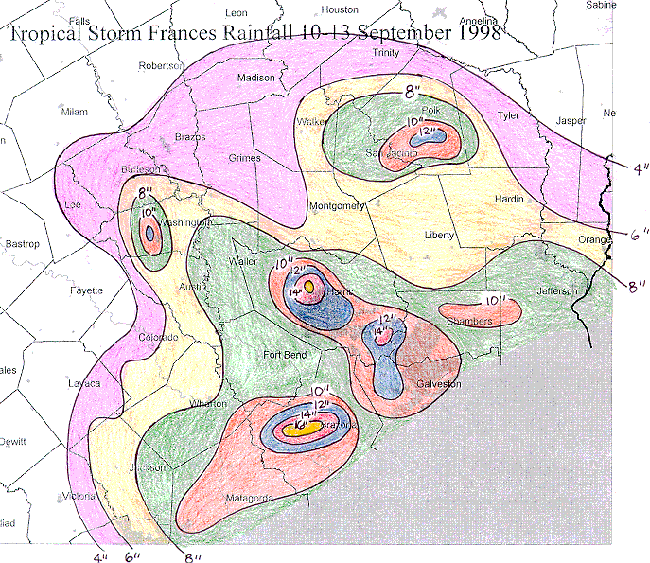
Frances on 9/11 - I've had an obsession with weather ever since
https://www.wpc.ncep.noaa.gov/tropical/ ... s1998.html
-
Ptarmigan
- Statistical Specialist
- Posts: 4527
- Joined: Wed Feb 03, 2010 7:20 pm
- Contact:
1932 Freeport, Humberto, and Harvey come to mind.srainhoutx wrote:Shear still impacting and aiding in thunderstorm flare up. The latest GFS suggests wind shear may relax late Wednesday into Thursday. Our 'back yard' in notorious for quick spin ups with little model support and advance warning. That's why we always keep a weary eye on the Western Gulf during peak season when tropical troubles are lurking.
-
Cpv17
- Posts: 7095
- Joined: Fri Aug 31, 2018 1:58 pm
- Location: El Campo/Wharton
- Contact:
I’m kind of in the same boat as you. I was just a kid at the time when Frances hit us, but I remember it very much. That was a pretty intense storm for us here in Wharton County. We got quite a bit of wind here from it.unome wrote:I remember 1998, it was the 1st time our home & neighborhood flooded from a tropical cyclone
Frances on 9/11 - I've had an obsession with weather ever since
https://www.wpc.ncep.noaa.gov/tropical/ ... s1998.html
-
ajurcat
- Posts: 77
- Joined: Tue Feb 23, 2010 10:59 am
- Location: NW Houston/Port Alto
- Contact:
1998 Francis struck us on White Oak Bayou. We watched our neighbors and sons classmates on TV being rescued by air boats.
-
ticka1
- Posts: 1265
- Joined: Wed Feb 03, 2010 3:02 pm
- Location: Baytown/Mont Belvieu
- Contact:
i convinced my hubby he was fiance then to go to Kemah and see the affects of Frances. We went over bridfe and wind was blowing us sideways. Kemah was flooded.unome wrote:I remember 1998, it was the 1st time our home & neighborhood flooded from a tropical cyclone
Frances on 9/11 - I've had an obsession with weather ever since
https://www.wpc.ncep.noaa.gov/tropical/ ... s1998.html
-
unome
- Posts: 3062
- Joined: Fri Feb 12, 2010 6:11 pm
we lived by White Oak then also, a volunteer rescue worker took me & our 2 little kids out on a jet ski - I ran into that guy in the grocery store a couple years later & thanked him, almost started crying - he didn't remember it, just said "It's what we do mam, I'm glad y'all are ok"ajurcat wrote:1998 Francis struck us on White Oak Bayou. We watched our neighbors and sons classmates on TV being rescued by air boats.
kudos to all you 1st responders
-
don

- Posts: 3148
- Joined: Wed Feb 03, 2010 3:33 pm
- Location: Wichita Falls
- Contact:
My family lost our house in Frances also, due to White Oak Bayou flooding, the water got high enough in our subdivision that we had to be rescued by boat.
-
jasons2k

- Posts: 6196
- Joined: Thu Feb 04, 2010 12:54 pm
- Location: Imperial Oaks
- Contact:
Francis was the first tropical storm I experienced since Hurricane Kate (then tropical storm Kate) in 1985 in Savannah, Ga. Francis was not forecast to dump as much rain as she did and caught the city off guard. I know a lot of people who went to work that day and got stuck during the commute. I remember seeing a gas station at Montrose & West Alabama full of cars and people trapped there for hours. The next year, I moved back to Dallas, so I missed Allison....but I will always remember Francis as the first big flooding event I witnessed.
Incidentally, the best track for Kate is slightly off. The official track is just to the northwest of Savannah. I was in downtown Savannah that day when what was left of the eye passed directly overhead. The wind went from the SE, to dead calm. We went outside. The sun peeked out for just a couple of minutes, and then it just got real eerie and quiet. Suddenly, there was an abrupt shift of wind from the NW. There was like a wall of leaves that came rushing down the street from out of nowhere. I'll never forget it...
Incidentally, the best track for Kate is slightly off. The official track is just to the northwest of Savannah. I was in downtown Savannah that day when what was left of the eye passed directly overhead. The wind went from the SE, to dead calm. We went outside. The sun peeked out for just a couple of minutes, and then it just got real eerie and quiet. Suddenly, there was an abrupt shift of wind from the NW. There was like a wall of leaves that came rushing down the street from out of nowhere. I'll never forget it...
-
jasons2k
- Posts: 6196
- Joined: Thu Feb 04, 2010 12:54 pm
- Location: Imperial Oaks
- Contact:
Some new bands with heavy rain (reds) starting to show-up to our SW towards Wharton and offshore.
-
Scott747
- Posts: 1648
- Joined: Tue Feb 23, 2010 9:56 am
- Location: Freeport/Surfside Beach
- Contact:
0z gfs was about the same as the 18z for 95l. Mainly a rain event.
Although for the first time both the Canadian and gfs bring Isaac into the gulf. Long range so easy to be skeptical.
Although for the first time both the Canadian and gfs bring Isaac into the gulf. Long range so easy to be skeptical.
-
Scott747
- Posts: 1648
- Joined: Tue Feb 23, 2010 9:56 am
- Location: Freeport/Surfside Beach
- Contact:
0z hwrf off the Florence run has a weak system into Matagorda Bay.