
SEPTEMBER 2018 - Very Wet Month Wrap Up
-
ticka1
- Posts: 1265
- Joined: Wed Feb 03, 2010 3:02 pm
- Location: Baytown/Mont Belvieu
- Contact:
Or will we see an easrly season cool front? Will it rain or not?
-
DoctorMu

- Posts: 8048
- Joined: Sun Jun 28, 2015 11:58 am
- Location: College Station
- Contact:
The stock answer for this area of Texas is yes to more heat, with increased rain chances in the Brazos Valley in 7-10 days.
100°F heat in early September, especially with desiccated ground is not unusual at all.
Slight chance of rain this Monday and Tuesday (20-30%)
GFS has a backdoor front just after Labor Day, moving temps from near 100°F to the lower 90s. We'll see.
100°F heat in early September, especially with desiccated ground is not unusual at all.
Slight chance of rain this Monday and Tuesday (20-30%)
GFS has a backdoor front just after Labor Day, moving temps from near 100°F to the lower 90s. We'll see.
-
srainhoutx

- Site Admin

- Posts: 19700
- Joined: Tue Feb 02, 2010 2:32 pm
- Location: Maggie Valley, NC
- Contact:
Interesting to see the GFS spinning up a phantom tropical trouble maker in the Bay of Campeche just after Labor Day.
Carla/Alicia/Jerry(In The Eye)/Michelle/Charley/Ivan/Dennis/Katrina/Rita/Wilma/Humberto/Ike/Harvey
Member: National Weather Association
Facebook.com/Weather Infinity
Twitter @WeatherInfinity
Member: National Weather Association
Facebook.com/Weather Infinity
Twitter @WeatherInfinity
-
Texaspirate11

- Posts: 1278
- Joined: Tue Dec 31, 2013 12:24 am
- Contact:
Yes but its the GFS..... 
Just because you're disabled, you don't have to be a victim
Be Weather Aware & Prepared!
Barbara Jordan Winner in Media
Disability Integration Consultant
Be Weather Aware & Prepared!
Barbara Jordan Winner in Media
Disability Integration Consultant
-
jasons2k

- Posts: 6196
- Joined: Thu Feb 04, 2010 12:54 pm
- Location: Imperial Oaks
- Contact:
We need to keep an eye on the eastern Atlantic wave. Most all the global models, including king Euro, are now developing it near the Bahamas, crossing the Florida peninsula, and then redeveloping again in the Gulf. Most send it to Louisiana but it's a long way off and much will change between now and then. Something to watch this week and into the holiday weekend.
-
ticka1
- Posts: 1265
- Joined: Wed Feb 03, 2010 3:02 pm
- Location: Baytown/Mont Belvieu
- Contact:
Not a forecast yet but cant discount the trends. With labor day fast approaching will we be spending our time watching the tropics? Need to monitor the trends and consistancy between models.jasons wrote:We need to keep an eye on the eastern Atlantic wave. Most all the global models, including king Euro, are now developing it near the Bahamas, crossing the Florida peninsula, and then redeveloping again in the Gulf. Most send it to Louisiana but it's a long way off and much will change between now and then. Something to watch this week and into the holiday weekend.
-
jasons2k
- Posts: 6196
- Joined: Thu Feb 04, 2010 12:54 pm
- Location: Imperial Oaks
- Contact:
Yesterday, the models were tracking the wave into Louisiana/Golden Triangle region and today they are taking it more into South Texas. I’m stating the obvious maybe, but it needs to be watched...
-
ticka1
- Posts: 1265
- Joined: Wed Feb 03, 2010 3:02 pm
- Location: Baytown/Mont Belvieu
- Contact:
Yes it needs to be watched.jasons wrote:Yesterday, the models were tracking the wave into Louisiana/Golden Triangle region and today they are taking it more into South Texas. I’m stating the obvious maybe, but it needs to be watched...
-
srainhoutx
- Site Admin
- Posts: 19700
- Joined: Tue Feb 02, 2010 2:32 pm
- Location: Maggie Valley, NC
- Contact:
Nothing but increasing moisture on the 12Z GFS, but the 12Z ECMWF does have a weak disturbance traveling from the Florida Straights across the Central Gulf and may be attempting to close off at 850mb as it nears S Texas around Labor Day. We will see.
- Attachments
-
Carla/Alicia/Jerry(In The Eye)/Michelle/Charley/Ivan/Dennis/Katrina/Rita/Wilma/Humberto/Ike/Harvey
Member: National Weather Association
Facebook.com/Weather Infinity
Twitter @WeatherInfinity
Member: National Weather Association
Facebook.com/Weather Infinity
Twitter @WeatherInfinity
-
srainhoutx
- Site Admin
- Posts: 19700
- Joined: Tue Feb 02, 2010 2:32 pm
- Location: Maggie Valley, NC
- Contact:
Michael VentriceVerified account @MJVentrice · 3h3 hours ago
Watching the Atlantic's Main Development Region this week into next for some strong African easterly waves to roll off Africa and potentially spin up into tropical cyclones. We are headed into the climatological peak of Atlantic Hurricanes. Nothing active as of today, however.
Watching the Atlantic's Main Development Region this week into next for some strong African easterly waves to roll off Africa and potentially spin up into tropical cyclones. We are headed into the climatological peak of Atlantic Hurricanes. Nothing active as of today, however.
- Attachments
-
Carla/Alicia/Jerry(In The Eye)/Michelle/Charley/Ivan/Dennis/Katrina/Rita/Wilma/Humberto/Ike/Harvey
Member: National Weather Association
Facebook.com/Weather Infinity
Twitter @WeatherInfinity
Member: National Weather Association
Facebook.com/Weather Infinity
Twitter @WeatherInfinity
-
jasons2k
- Posts: 6196
- Joined: Thu Feb 04, 2010 12:54 pm
- Location: Imperial Oaks
- Contact:
Caught this tidbit in the NWS's overnight discussion:
The extended guidance has been indicating a weakness sliding across
the southern Gulf with radically different levels of organization
Sunday through Wednesday next week. Keep in mind that often the
extended guidance waffles around spurious solutions - is it
possible yes is it something to get worried about not yet - but
aware of yes.
-
stormlover
- Posts: 439
- Joined: Wed Dec 04, 2013 10:21 am
- Location: Lumberton TX
- Contact:
Euro is on board, tropical storm north of corpus looks like a rita type track going through the straights could be interesting.
-
jasons2k
- Posts: 6196
- Joined: Thu Feb 04, 2010 12:54 pm
- Location: Imperial Oaks
- Contact:
Yep, today's Euro run is more defined than previous runs. The NW Gulf has a history of storms intensifying near landfall on the Texas coast...Claudette, Humberto, and Harvey come to mind.
-
srainhoutx
- Site Admin
- Posts: 19700
- Joined: Tue Feb 02, 2010 2:32 pm
- Location: Maggie Valley, NC
- Contact:
Take it with a grain of salt at this time, but being near the climatological peak of Hurricane Season we will continue to monitor.stormlover wrote:Euro is on board, tropical storm north of corpus looks like a rita type track going through the straights could be interesting.
- Attachments
-
Carla/Alicia/Jerry(In The Eye)/Michelle/Charley/Ivan/Dennis/Katrina/Rita/Wilma/Humberto/Ike/Harvey
Member: National Weather Association
Facebook.com/Weather Infinity
Twitter @WeatherInfinity
Member: National Weather Association
Facebook.com/Weather Infinity
Twitter @WeatherInfinity
-
Ptarmigan

- Statistical Specialist

- Posts: 4527
- Joined: Wed Feb 03, 2010 7:20 pm
- Contact:
Hurricane Lane is one of the wettest tropical cyclone in America.
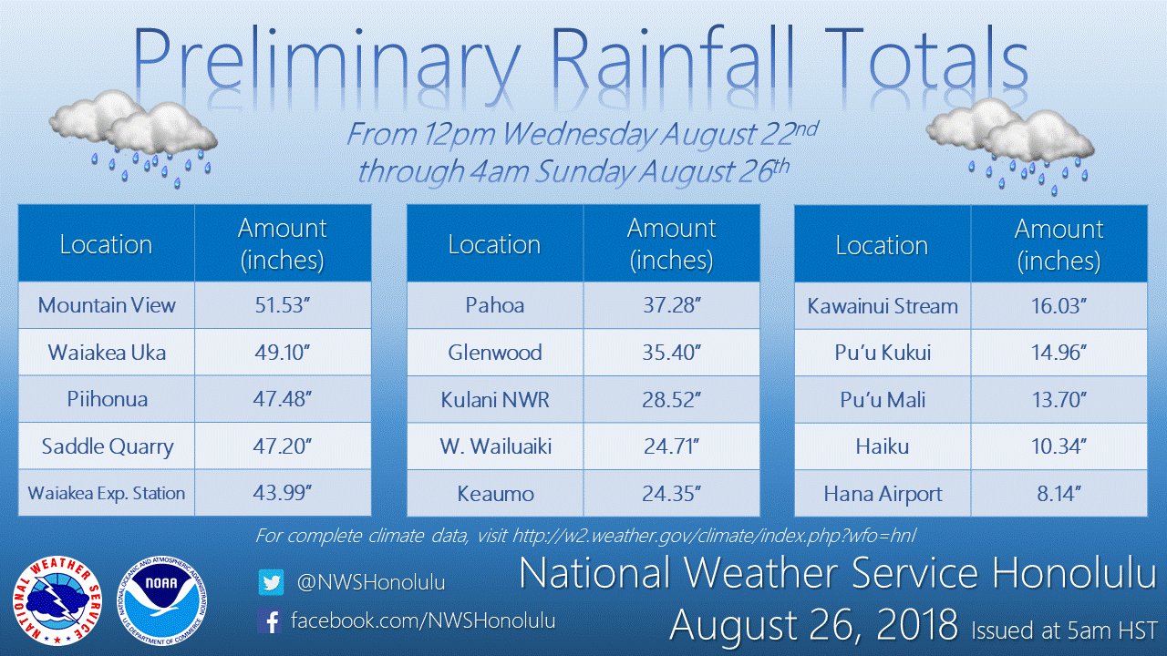
Hurricane Lane is the third wettest so far. It is very close to dethroning Hurricane Hiki, which dumped 52 inches of rain in 1950. Harvey remains the wettest for America with over 60 inches of rain. Interesting to note this happened a year after Harvey.
Wettest American Tropical Cyclones
Harvey (2017) 70 Inches (Doppler radar estimated)
Hiki (1950) 52 Inches
Lane (2018) 51.52 Inches
Amelia (1978) 48.00 Inches
Easy (1950) 45.20 Inches
Claudette (1979) 45.00 Inches
TD #15 (1970) 41.68 Inches
Allison (2001) 40.68 Inches
Hurricane #2 (1921) 40.00 Inches
Paul (2000) 38.76 Inches
Georges (1998) 38.46 Inches
https://en.wikipedia.org/wiki/List_of_w ... ted_States
Harvey, Amelia, Claudette, Allison, and Hurricane #2 (1921) occurred in Texas. Claudette dumped 43 inches in 24 hours, while Hurricane #2 (1921) dumped 38.20 inches in 24 hours including 32 inches in 12 hours! Interesting to note Texas holds many top 10 for wettest tropical cyclones in America.
-
ticka1
- Posts: 1265
- Joined: Wed Feb 03, 2010 3:02 pm
- Location: Baytown/Mont Belvieu
- Contact:
Looks like forecast for Holiday weekend will be chance of rain!
-
mcheer23
- Global Moderator

- Posts: 606
- Joined: Fri Jan 11, 2013 11:15 am
- Location: Missouri City/ Sugar Land
- Contact:
EURO brings a decent system across Miami and then into New Orleans.....something to watch.
-
stormlover
- Posts: 439
- Joined: Wed Dec 04, 2013 10:21 am
- Location: Lumberton TX
- Contact:
-
jasons2k
- Posts: 6196
- Joined: Thu Feb 04, 2010 12:54 pm
- Location: Imperial Oaks
- Contact:
Seems to be going back and forth between Louisiana and South Texas with each run. Much will depend on timing and the strength of the ridge.
-
srainhoutx
- Site Admin
- Posts: 19700
- Joined: Tue Feb 02, 2010 2:32 pm
- Location: Maggie Valley, NC
- Contact:
I see no change regarding our sensible weather as the Long Labor Day Holiday Weekend begins and ends. What you see out there today will likely be the same pattern we can expect during the Long Weekend. The 7 Day QPF charts paint an unsettled pattern with a series of inverted troughs moving West beneath the flattened out Upper Ridge across the Mid West into the Mid Atlantic.
Beyond the 7 Day forecast, there is noise in the models regarding later next week, but I see nothing at this time to get too worked up over. We are certainly in better shape today than we were a year ago at this time... 
Carla/Alicia/Jerry(In The Eye)/Michelle/Charley/Ivan/Dennis/Katrina/Rita/Wilma/Humberto/Ike/Harvey
Member: National Weather Association
Facebook.com/Weather Infinity
Twitter @WeatherInfinity
Member: National Weather Association
Facebook.com/Weather Infinity
Twitter @WeatherInfinity