
January: Increasing Clouds/Rain & Warmer To End Month
-
srainhoutx

- Site Admin

- Posts: 19700
- Joined: Tue Feb 02, 2010 2:32 pm
- Location: Maggie Valley, NC
- Contact:
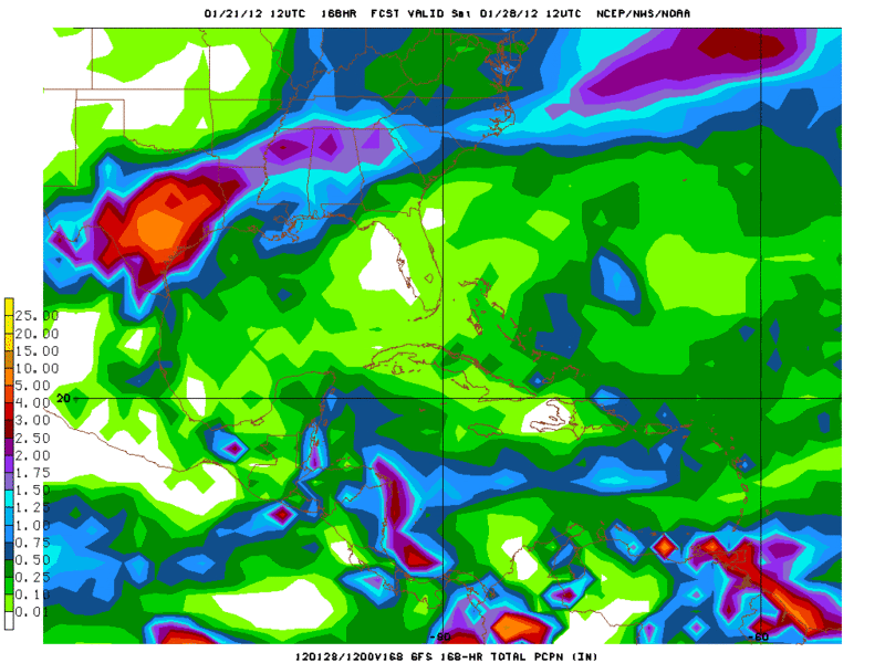
Very impressive rainfall totals via the 12Z GFS ensemble mean for 120 hour period ending at hour 192...
- Attachments
-
Carla/Alicia/Jerry(In The Eye)/Michelle/Charley/Ivan/Dennis/Katrina/Rita/Wilma/Humberto/Ike/Harvey
Member: National Weather Association
Facebook.com/Weather Infinity
Twitter @WeatherInfinity
Member: National Weather Association
Facebook.com/Weather Infinity
Twitter @WeatherInfinity
-
srainhoutx
- Site Admin
- Posts: 19700
- Joined: Tue Feb 02, 2010 2:32 pm
- Location: Maggie Valley, NC
- Contact:
Looking ahead to the longer range, the 12Z Euro suggests a deep trough developing across the West/Intermountain West and Plains.
Carla/Alicia/Jerry(In The Eye)/Michelle/Charley/Ivan/Dennis/Katrina/Rita/Wilma/Humberto/Ike/Harvey
Member: National Weather Association
Facebook.com/Weather Infinity
Twitter @WeatherInfinity
Member: National Weather Association
Facebook.com/Weather Infinity
Twitter @WeatherInfinity
-
Andrew
- Site Admin
- Posts: 3508
- Joined: Wed Feb 03, 2010 9:46 pm
- Location: North-West Houston
- Contact:
Pretty impressive North Pacific Ridge just wish it was a little farther north to completely dislodge all the cold air in Alaska but either way some impressive heights both rising in the pacific and lowering along the west coast.srainhoutx wrote:Looking ahead to the longer range, the 12Z Euro suggests a deep trough developing across the West/Intermountain West and Plains.
For Your Infinite Source For All Things Weather Visit Our Facebook
-
jasons2k

- Posts: 6192
- Joined: Thu Feb 04, 2010 12:54 pm
- Location: Imperial Oaks
- Contact:
I can still see the front on Level II - it's from near Lake Jackson to Kemah. It's losing its punch quickly though - as noted in the Aviation discussion, CAA is dropping off rapidly and the front is washing out.
-
Katdaddy

- Global Moderator

- Posts: 2521
- Joined: Thu Feb 04, 2010 8:18 am
- Location: League City, Tx
- Contact:
Its perfect weather down here in League City...mostly sunny, 72F, and a refreshing NW breeze. I better enjoy this weather because a very stormy week ahead......as Ed said Happiness, page after page. Finally some signifcant weather events to discuss.....Last year felt like an empty rain gauge 
-
txflagwaver

- Posts: 411
- Joined: Wed Feb 03, 2010 2:37 pm
- Location: Seabrook/Kemah
- Contact:
Was out working in the yard when it blew through...not real cold air...but definitely feel the difference 
-
mckinne63
- Posts: 553
- Joined: Fri Jul 08, 2011 4:50 pm
- Location: Stafford, TX
- Contact:
Very overcast in Stafford. Temp is pleasant since whatever front blew through. Was ugly this morning, muggy and humid. Not sure what the KHOU weatherguy is talking about when he says "a cool start to Saturday morning".  Had some rain droplets this morning too. Not alot, but enough to make me run my wipers when driving. Am happy that I could turn the a/c off and open the windows. I do not like having to run the a/c in January.
-
Ptarmigan

- Statistical Specialist

- Posts: 4517
- Joined: Wed Feb 03, 2010 7:20 pm
- Contact:
The models are showing a widespread rain event, which is a good thing. 
-
Portastorm

- Posts: 800
- Joined: Wed Feb 03, 2010 3:04 pm
- Location: Southwest Austin/Oak Hill, TX
- Contact:
And given that guidance, I'm just baffled at why my local NWSFO (EWX) is talking 2 inches max and maybe less. Their area forecast discussion (AFD) issued this afternoon was a "head scratcher." They think the low will do a sit-and-spin in Mexico and essentially spin itself out with maybe as little as 1/4 to 1/2 inch of rain for south central Texas. 
Well, they've got a few days to get it right.
Well, they've got a few days to get it right.
-
Ptarmigan
- Statistical Specialist
- Posts: 4517
- Joined: Wed Feb 03, 2010 7:20 pm
- Contact:
If it sit-and-spin, shouldn't that mean more rain.Portastorm wrote:And given that guidance, I'm just baffled at why my local NWSFO (EWX) is talking 2 inches max and maybe less. Their area forecast discussion (AFD) issued this afternoon was a "head scratcher." They think the low will do a sit-and-spin in Mexico and essentially spin itself out with maybe as little as 1/4 to 1/2 inch of rain for south central Texas.
Well, they've got a few days to get it right.
-
jasons2k
- Posts: 6192
- Joined: Thu Feb 04, 2010 12:54 pm
- Location: Imperial Oaks
- Contact:
I love it - now the question is is the GFS too fast and east? We're getting close to the timeframe where the models will come into agreement (hopefully).
-
Andrew
- Site Admin
- Posts: 3508
- Joined: Wed Feb 03, 2010 9:46 pm
- Location: North-West Houston
- Contact:
You don't see saturation through all levels so precise that often like what the gfs Skew-T is showing. Very impressive. I think this next ULL is going to put the last one to shame.
For Your Infinite Source For All Things Weather Visit Our Facebook
-
Kludge

- Posts: 280
- Joined: Wed Feb 03, 2010 11:53 pm
- Location: Montgomery (Walden) TX
- Contact:
So many of you metro Houston folks scored big with the early January downpours that helped dig you you out of the drought... but we didn't get much help out here on the NW side of the CWA. Only 1.25" here while so many of you poured 4"+ out of your rain guages. 
My fingers are crossed that...especially with the PW numbers i'm seeeing in conjunction with the training storm potential...we could also start to end the drought hell that seems to have lasted forever up here.
Thanks...as always, Steve, for your round-the-clock updates on the upcoming possibilities...!!! ...and let's hope we all score big this week.
-
weatherguy425
- Pro Met

- Posts: 830
- Joined: Wed Feb 03, 2010 7:45 pm
- Location: Atlanta, Georgia
- Contact:
Even though there may well be several rounds of rain... the idea of a slow moving squall line is some what reminiscent of the October '94 event.
P.S. The long range GFS is really annoying...first all the cold air was consistently shown to be in western Canada, now it's in eastern Canada being pulled towards the east coast by a monster coastal low/Nor'easter! Models, models, models
P.S. The long range GFS is really annoying...first all the cold air was consistently shown to be in western Canada, now it's in eastern Canada being pulled towards the east coast by a monster coastal low/Nor'easter! Models, models, models
-
Andrew
- Site Admin
- Posts: 3508
- Joined: Wed Feb 03, 2010 9:46 pm
- Location: North-West Houston
- Contact:
Kludge wrote:So many of you metro Houston folks scored big with the early January downpours that helped dig you you out of the drought... but we didn't get much help out here on the NW side of the CWA. Only 1.25" here while so many of you poured 4"+ out of your rain guages.
My fingers are crossed that...especially with the PW numbers i'm seeeing in conjunction with the training storm potential...we could also start to end the drought hell that seems to have lasted forever up here.
Thanks...as always, Steve, for your round-the-clock updates on the upcoming possibilities...!!! ...and let's hope we all score big this week.
Where/ if the ULL Stalls is going to be key. Current thinking would put a MUCH wider amount of the area in the "bulls-eye". If we get severe storms it will be most likely be closer to the coast where the flow from the gulf will help.
For Your Infinite Source For All Things Weather Visit Our Facebook
-
srainhoutx
- Site Admin
- Posts: 19700
- Joined: Tue Feb 02, 2010 2:32 pm
- Location: Maggie Valley, NC
- Contact:
Thanks for the kind words, Kludge. At this hour there is a G-IV flying out over the NE Pacific dropping 16 sondes from 45K feet. That data should be in the 12Z guidance later today. We share that data with Canada, The Brits and the Europeans. Hopefully the 12Z suite will offer solutions that will answer a lot of questions we have. I've been honking this storm threat for two weeks. It's nice to see some of that longer range 'hints' in the pattern come to pass. We have a long week ahead and probably many more hours and weeks to follow before this winter is a distant memory...
Carla/Alicia/Jerry(In The Eye)/Michelle/Charley/Ivan/Dennis/Katrina/Rita/Wilma/Humberto/Ike/Harvey
Member: National Weather Association
Facebook.com/Weather Infinity
Twitter @WeatherInfinity
Member: National Weather Association
Facebook.com/Weather Infinity
Twitter @WeatherInfinity
-
svrwx0503

- Pro Met
- Posts: 230
- Joined: Thu Feb 04, 2010 8:48 pm
- Location: West Harris County
- Contact:
With a sounding like that, we are going to see some very significant rainfall rates even in the more moderate showers. You are correct Andrew, even during the summer months it isn't too often that we see a sounding like that. You see that type of saturation in more tropical areas like south Florida and definitely not often during January! I will have additional details on this event over the next few days.Andrew wrote:You don't see saturation through all levels so precise that often like what the gfs Skew-T is showing. Very impressive. I think this next ULL is going to put the last one to shame.
-
srainhoutx
- Site Admin
- Posts: 19700
- Joined: Tue Feb 02, 2010 2:32 pm
- Location: Maggie Valley, NC
- Contact:
Some thoughts this morning before the 12Z suite comes out. The Euro is a bit too progressive and is considered an outlier as is the Canadian. A slower ejection E of the U/L has been the pattern all season. There remain some questions as to the amount of phasing with the northern stream short wave and how that will affect our southern cyclone. The data gained from the RECON mission 22/00Z aided the 00Z GFS/NAM/Euro output and was ingested as that mission covered a large area from HI to AK to just off the California Coast. The GFS/UKMet blend with a bit of Euro early on seems like the best solution for now and the HPC mentions that in their very early morning update. I do want to mention the severe potential as well. The day 3 SPC is talking about an isolated tornado or two for S Texas as the Coastal low develops and slowly translates NE up the Coast. As has been mentioned, the atmosphere will be very moist through all levels in a very un January fashion. The Sunday front will slowly retreat N and just where that boundary stalls will be key. We'll look at the operational data for the 12Z suite and hopefully have some more details as to what we can expect. I encourage everyone to follow the weather very closely the next several days as we are likely headed toward a very active couple of days beginning Tuesday through Thursday.
Carla/Alicia/Jerry(In The Eye)/Michelle/Charley/Ivan/Dennis/Katrina/Rita/Wilma/Humberto/Ike/Harvey
Member: National Weather Association
Facebook.com/Weather Infinity
Twitter @WeatherInfinity
Member: National Weather Association
Facebook.com/Weather Infinity
Twitter @WeatherInfinity
-
srainhoutx
- Site Admin
- Posts: 19700
- Joined: Tue Feb 02, 2010 2:32 pm
- Location: Maggie Valley, NC
- Contact:
Just a quick update as the 06Z GFS is suggesting some QPF totals of 5+ inches for areas E of of the I-35 corridor into SE TX and on NE.
Carla/Alicia/Jerry(In The Eye)/Michelle/Charley/Ivan/Dennis/Katrina/Rita/Wilma/Humberto/Ike/Harvey
Member: National Weather Association
Facebook.com/Weather Infinity
Twitter @WeatherInfinity
Member: National Weather Association
Facebook.com/Weather Infinity
Twitter @WeatherInfinity