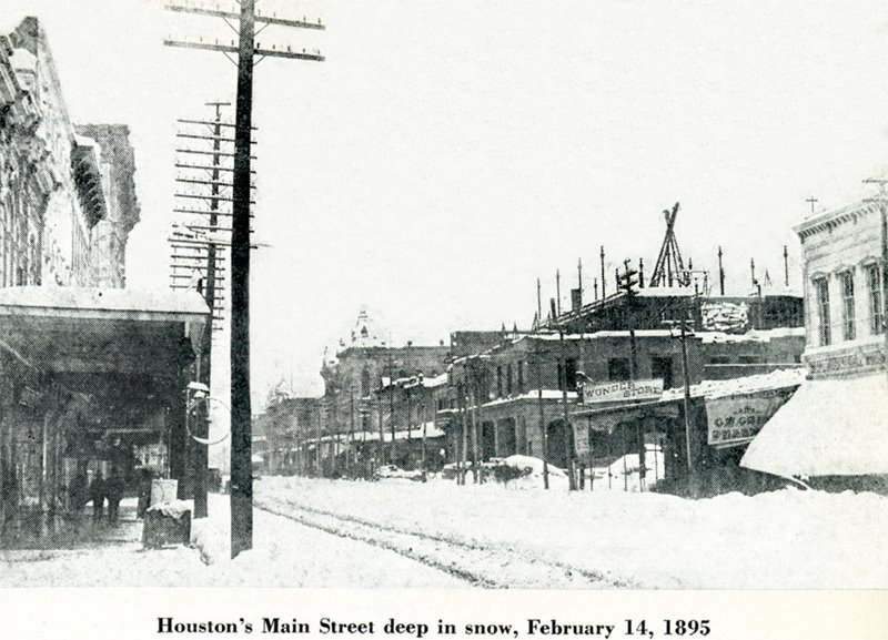
Yes, the 1895 outbreak wasn't as severe as 1899. What was so memorable about 1895 was the tremendous snowfall that happened across the deep south. There are several write ups about the storm. Essentially, it was a 2004 type setup but probably a little slower moving and a bit further north. If my memory serves me correctly, the Texas 24-hr snowfall record is actually held in Beaumont at 30 inches. But I will double check to be sure. Here is Main Street, Downtown Houston, TX the day after the storm.
Correction: The 24-hr snow record was set in 1956 in Plainview, TX at 24 inches. The only reason Beaumont doesn't hold the record is because the 30+ inches was never verified. However, there are MULTIPLE reports of 30 inches stretching into southwest Louisiana.
djmike wrote:I just found out about the MAJOR arctic blast that hit Houston/SE Texas in 1895. I'd love to see those forecast's and maps from way back when. 20" of snow for Houston/Beaumont? Low of 6-11 degrees? WOW! Many rivers and lakes were frozen solid and people were ice skating across the Sabine river to Louisiana...WOW.
Anyone know of a good site that explains what happened or has weather maps or anything from this time period on this subject?
Sorry, I know it's off topic...
February 1895 had temperatures into the teens in Houston. February 1899 had back to back single digit temperatures, which is very rare. Both had snow, especially 1895. Those freezes had a huge impact on North America and Europe.
djmike wrote:I just found out about the MAJOR arctic blast that hit Houston/SE Texas in 1895. I'd love to see those forecast's and maps from way back when. 20" of snow for Houston/Beaumont? Low of 6-11 degrees? WOW! Many rivers and lakes were frozen solid and people were ice skating across the Sabine river to Louisiana...WOW.
Anyone know of a good site that explains what happened or has weather maps or anything from this time period on this subject?
Sorry, I know it's off topic...
NOAA Central Library
U.S. Daily Weather Maps Project
For daily maps from 1871-1968 & weekly maps from April 15, 1968-
Alright. Who stole wxman57's 'password'...the long range NAM suggests our potential weather trouble maker is SE of the Aleutians...We'll see what the globals offer tonight...
Attachments
Carla/Alicia/Jerry(In The Eye)/Michelle/Charley/Ivan/Dennis/Katrina/Rita/Wilma/Humberto/Ike/Harvey
Member: National Weather Association
Facebook.com/Weather Infinity
Twitter @WeatherInfinity
The over night guidance has come better agreement and now suggest that very potent storm system will cross the region as a deep mid latitude trough develops with a organized southern stream upper low approaching next Wednesday, the 25th. HGX is suggesting that this storm complex has the look of what we saw on January 9th when very heavy rains/severe weather affected SE TX. Once again there will be a boundary stalled very close the Central/SE TX that could serve as a focal point for heavy rainfall and hints of a Coastal wave/low developing early next week as the upper low approaches. Stay tuned as it is appearing we are heading toward yet another very active period.
Looking ahead, as Andrew mentioned, there are growing signals of a significant 'cool down' early February. More on that as we move forward...
Carla/Alicia/Jerry(In The Eye)/Michelle/Charley/Ivan/Dennis/Katrina/Rita/Wilma/Humberto/Ike/Harvey
Member: National Weather Association
Facebook.com/Weather Infinity
Twitter @WeatherInfinity
GFS appears to be having all kinds of problems with next week's weather system. Euro/Canadian move the upper trof/front through Wednesday afternoon/evening. GFS holds the system back until late Friday. Since it can't seem to handle the pattern over the next 5-7 days, I wouldn't trust it in the long range. Euro, Canadian and GFS don't match up well at 240 hrs. GFS is still indicating a weaker ridge over the Gulf of AK at 300+ hrs and a shot of Canadian/Arctic air down the Plains in the last few panels. But it delays the cold air and the high in the States is only 1033mb now. I wouldn't trust it as far as I can throw it.
But since there IS some cold air in Canada, we'll have to watch for something that might nudge it southward after next week.
Warm and humid air mass returning to the region after one cool day yesterday.
Surface high moving eastward in the progressive upper level flow will result in southerly surface winds bring higher dewpoints back into the region. Offshore buoys this morning show mid to upper 60 degree dewpoints poised to make a return by the weekend and with near shore/bay water temperatures in the upper 50’s to low 60’s sea fog seems a good bet starting tonight and continuing through the weekend. As moist air moves over the colder waters and dewpoints exceed water temperatures by 2-3 degrees expect a dense bank of sea fog to develop from Matagorda Bay to coastal Louisiana. Winds from the S to SSW are not in an overly favorable direction for an extended period of time for the higher dewpoint air to chill to saturation an east to ESE wind would be more favorable. Thus expect a narrow, but thick bank of sea fog to form near the coast and over the bays and linger through much of the weekend. Visibilities will vary greatly near the coast over the next 2-4 days as the fog moves inland at times with high visibilities falling rapidly to less than .50 of a mile in the fog bank. Sea fog will advance inland starting each evening likely reaching US 59 by 8-10pm and then HWY 105 by 2-3am. Fog will linger into the mid to late morning hours each day for lifting and breaking into a scattered low level deck. Along the coast many locations may stay socked in all day, especially around Galveston Bay eastward across Bolivar into Jefferson County.
Otherwise temperatures will be very warm for mid January with highs running in the mid to upper 70’s and lows from the mid to upper 60’s by the weekend. Overnight lows will be averaging 15-20 degrees above normal and daytime highs 10-15 degrees above normal. Dry air above the very moist surface layer will keep rain chances on the low side through Monday. Could be a weak frontal intrusion into at least the northern sections of the area Sunday, but for now will not put much faith in this providing much of a cool down.
Next potential significant weather maker appears to be shaping up for the middle of next week with the models having some difficulty as they have had much of this winter season on resolving the timing, track, and intensity of the next upper level trough. Given the poor consistency of the models and the fact that the event is still about 6 days away, will defer to later time periods for more in depth discussion on this possible event. First feeling is that the drier and warmer pattern following more typical La Nina winter patterns may eventually work into what otherwise appears to be another possible heavy rainfall/severe weather event. Minus the Jan 9 event it has become increasing dry again across the state as La Nina conditions have taken a bigger stand a worrisome trend given the historical drought still in place.
Carla/Alicia/Jerry(In The Eye)/Michelle/Charley/Ivan/Dennis/Katrina/Rita/Wilma/Humberto/Ike/Harvey
Member: National Weather Association
Facebook.com/Weather Infinity
Twitter @WeatherInfinity
wxman57 wrote:GFS appears to be having all kinds of problems with next week's weather system. Euro/Canadian move the upper trof/front through Wednesday afternoon/evening. GFS holds the system back until late Friday. Since it can't seem to handle the pattern over the next 5-7 days, I wouldn't trust it in the long range. Euro, Canadian and GFS don't match up well at 240 hrs. GFS is still indicating a weaker ridge over the Gulf of AK at 300+ hrs and a shot of Canadian/Arctic air down the Plains in the last few panels. But it delays the cold air and the high in the States is only 1033mb now. I wouldn't trust it as far as I can throw it.
But since there IS some cold air in Canada, we'll have to watch for something that might nudge it southward after next week.
I just looked at the over night ensembles. What they do suggest is snow cover building across Canada down into the Northern Plains with intrusions of snow events into the Central Plains with the active northern stream. That said, there still remains a lot of spread regarding the AO/PNA regime. It does appear via all the ensemble data that a -EPO will return and a +WPO will develop as well.
Carla/Alicia/Jerry(In The Eye)/Michelle/Charley/Ivan/Dennis/Katrina/Rita/Wilma/Humberto/Ike/Harvey
Member: National Weather Association
Facebook.com/Weather Infinity
Twitter @WeatherInfinity
Interesting blog post this morning from Chronicle science writer Eric Berger. He quotes ImpactWeather's Fred Schmude who says winter *may* make a real appearance in early February. Read on ...
Portastorm wrote:Interesting blog post this morning from Chronicle science writer Eric Berger. He quotes ImpactWeather's Fred Schmude who says winter *may* make a real appearance in early February. Read on ...