
March 2026
-
DoctorMu

- Posts: 8016
- Joined: Sun Jun 28, 2015 11:58 am
- Location: College Station
- Contact:
That line developing near Wichita Falls bears watching as it continues to lengthen and migrates SE. Hope Don is secure.
-
tireman4

- Global Moderator

- Posts: 7123
- Joined: Wed Feb 03, 2010 9:24 pm
- Location: Humble, Texas
- Contact:
-
tireman4
- Global Moderator
- Posts: 7123
- Joined: Wed Feb 03, 2010 9:24 pm
- Location: Humble, Texas
- Contact:
From Jeff Lindner on Facebook
3-7-26 645am
Widespread showers and thunderstorms will move into and develop across the region this afternoon into tonight as a slow moving cold front stalls over the area.
A few of the severe may become severe with large hail and damaging winds. This will be especially true for any discrete cells that could form this afternoon ahead of the front.
Heavy rainfall of 1-2 inches is also possible. Front looks to stall between I-10 and the coast into Sunday morning where repeated cell training could yield rainfall amounts upwards of 4 inches. Given dry grounds no significant flooding is expected.
Timing of activity is a bit tough as not sure if/when storms will develop ahead of the front…if so could be as early as midday with more likely into the evening and overnight hours.
-
DoctorMu
- Posts: 8016
- Joined: Sun Jun 28, 2015 11:58 am
- Location: College Station
- Contact:
As expected, the showers are degrading to more streamer types. Maybe the second wave?
Mesos are mostly Hold or Sell south of Hwy 1*5.
Late Tuesday/Wednesday FROPA remains more of a Buy for me still on rain.

Mesos are mostly Hold or Sell south of Hwy 1*5.
Late Tuesday/Wednesday FROPA remains more of a Buy for me still on rain.
- Attachments
-
- namconus_apcpn_us_12.png
- (119.94 KiB) Not downloaded yet
-
Cromagnum
- Posts: 3065
- Joined: Thu Feb 03, 2011 10:42 pm
- Location: Georgetown
- Contact:
We had all these warnings about severe weather and hail today, but it barely even rained. We'll see how the Houston area does later.
-
DoctorMu
- Posts: 8016
- Joined: Sun Jun 28, 2015 11:58 am
- Location: College Station
- Contact:
Less that a 1/10 of an inch so far from the weak streamer showers. Maybe a line forms later around Hwy 1*5. We'll see.
The only strong line of showers is from Greenville, MS to Nashville.
-
don

- Posts: 3148
- Joined: Wed Feb 03, 2010 3:33 pm
- Location: Wichita Falls
- Contact:
Tuesday is looking more and more interesting. 
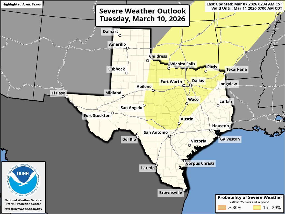

Day 4-8 Convective Outlook
NWS Storm Prediction Center Norman OK
0234 AM CST Sat Mar 07 2026
Valid 101200Z - 151200Z
...DISCUSSION...
...Days 4-5/Tue-Wed...
An active pattern with severe thunderstorm potential is expected
Tuesday and Wednesday from the southern Plains to the Mid/Lower MS
and OH Valleys. Medium range guidance is in fairly good agreement
during this time. Starting on Tuesday, an upper low over northern
Mexico will shift east/northeast, becoming an open wave as it begins
to merge with a northern stream upper trough developing southeast
across the northern/central Plains through early Wednesday. A belt
of strong southwesterly deep-layer flow will overspread a large warm
sector on Tuesday. Lee cyclogenesis is forecast across the
central/southern High Plains, along with a second surface low
developing over IA as the northern stream upper trough approaches.
This setup will allow for a sharpening dryline/Pacific front across
the southern Plains, while a cold front develops southeast into the
MO/Mid-MS Valley overnight. Strong ascent should focus thunderstorm
development across the warm sector ahead of these surface boundaries
within a strongly sheared environment, and potentially widespread
severe thunderstorm activity is possible.
-
DoctorMu
- Posts: 8016
- Joined: Sun Jun 28, 2015 11:58 am
- Location: College Station
- Contact:
Yeah - Tuesday into Wednesday could be interesting, even in CLL. It depends how far northward the Mexican low ejects.
For now, SETX continues to redefine “broken line of showers.”
For now, SETX continues to redefine “broken line of showers.”
-
tireman4
- Global Moderator
- Posts: 7123
- Joined: Wed Feb 03, 2010 9:24 pm
- Location: Humble, Texas
- Contact:
Jeff Lindner on Facebook
3-7-26 300pm
Front slowly moving into the area with uptick in storm coverage and intensity. So far no severe weather, and think the threat remains isolated into the evening hours.
Much needed rain falling across areas NW of the metro area
3-7-26 300pm
Front slowly moving into the area with uptick in storm coverage and intensity. So far no severe weather, and think the threat remains isolated into the evening hours.
Much needed rain falling across areas NW of the metro area
- Attachments
-
- FB_IMG_1772917596644.jpg
- (337.31 KiB) Not downloaded yet
-
MH5
- Posts: 65
- Joined: Mon Jun 22, 2020 2:20 pm
- Location: Timbergrove
- Contact:
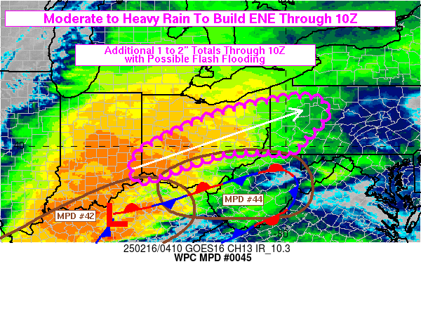
Let's see how this afternoon and evening develops, but looks like WPC thinks we could get a good soaking.. Nothing but blips off to the north so far
-
Stratton20
- Posts: 5815
- Joined: Tue Feb 09, 2021 11:35 pm
- Location: College Station, Texas
- Contact:
Its laughable, the line is breaking up right on my door step, its literally going around me, just sad at this point, but also predictable
-
tireman4
- Global Moderator
- Posts: 7123
- Joined: Wed Feb 03, 2010 9:24 pm
- Location: Humble, Texas
- Contact:
Radar
- Attachments
-
- KHGX_loop.gif (699.87 KiB) Viewed 1613 times
-
suprdav2
- Posts: 141
- Joined: Thu Feb 04, 2010 5:39 pm
- Location: Cypress, TX
- Contact:
Getting pretty good downpours and lightning here in Cypress
-
DoctorMu
- Posts: 8016
- Joined: Sun Jun 28, 2015 11:58 am
- Location: College Station
- Contact:
There's some action near the Woodlands. The show is over up here. We got lucky with a cell that dumped a little over half an inch. It's something in the expected range. Not a complete bust.
-
Brazoriatx979
- Posts: 545
- Joined: Tue Nov 26, 2024 10:10 am
- Location: Angleton
- Contact:
So nothing on the south side im guesing?
-
suprdav2
- Posts: 141
- Joined: Thu Feb 04, 2010 5:39 pm
- Location: Cypress, TX
- Contact:
And now pea sized hail
-
Stratton20
- Posts: 5815
- Joined: Tue Feb 09, 2021 11:35 pm
- Location: College Station, Texas
- Contact:
This line is going to be a big nothing burger for most areas south of i-10, most of the activity is north of houston, just embarrassing
-
tireman4
- Global Moderator
- Posts: 7123
- Joined: Wed Feb 03, 2010 9:24 pm
- Location: Humble, Texas
- Contact:
Lots of noise in the neighborhood in Humble.....from Jeff Lindner on Facebook
3-7-26 540pm
Strong storms with very heavy rainfall, gusty winds, small hail and frequent lightning moving eastward.
A few locations have recorded 1 inch of rain in 15 minutes so some street flooding is likely with those type of rates
3-7-26 540pm
Strong storms with very heavy rainfall, gusty winds, small hail and frequent lightning moving eastward.
A few locations have recorded 1 inch of rain in 15 minutes so some street flooding is likely with those type of rates
- Attachments
-
- FB_IMG_1772927912968.jpg
- (379.84 KiB) Not downloaded yet
-
tireman4
- Global Moderator
- Posts: 7123
- Joined: Wed Feb 03, 2010 9:24 pm
- Location: Humble, Texas
- Contact:
Still raining in Humble. Boy, we needed it
-
suprdav2
- Posts: 141
- Joined: Thu Feb 04, 2010 5:39 pm
- Location: Cypress, TX
- Contact:
Got almost 2.5" of much needed rain. And washed some pollen away!