
Crazy
Tropical Discussion 2025
-
Rip76

- Posts: 2126
- Joined: Mon Feb 15, 2010 12:38 am
- Location: The Woodlands
- Contact:
-
sambucol

- Posts: 1244
- Joined: Wed Feb 03, 2010 5:43 pm
- Location: Mont Belvieu
- Contact:
The one coming off Africa has my attention at this point.
-
snowman65

- Posts: 1415
- Joined: Thu Feb 04, 2010 6:39 am
- Location: Orange, Tx
- Contact:
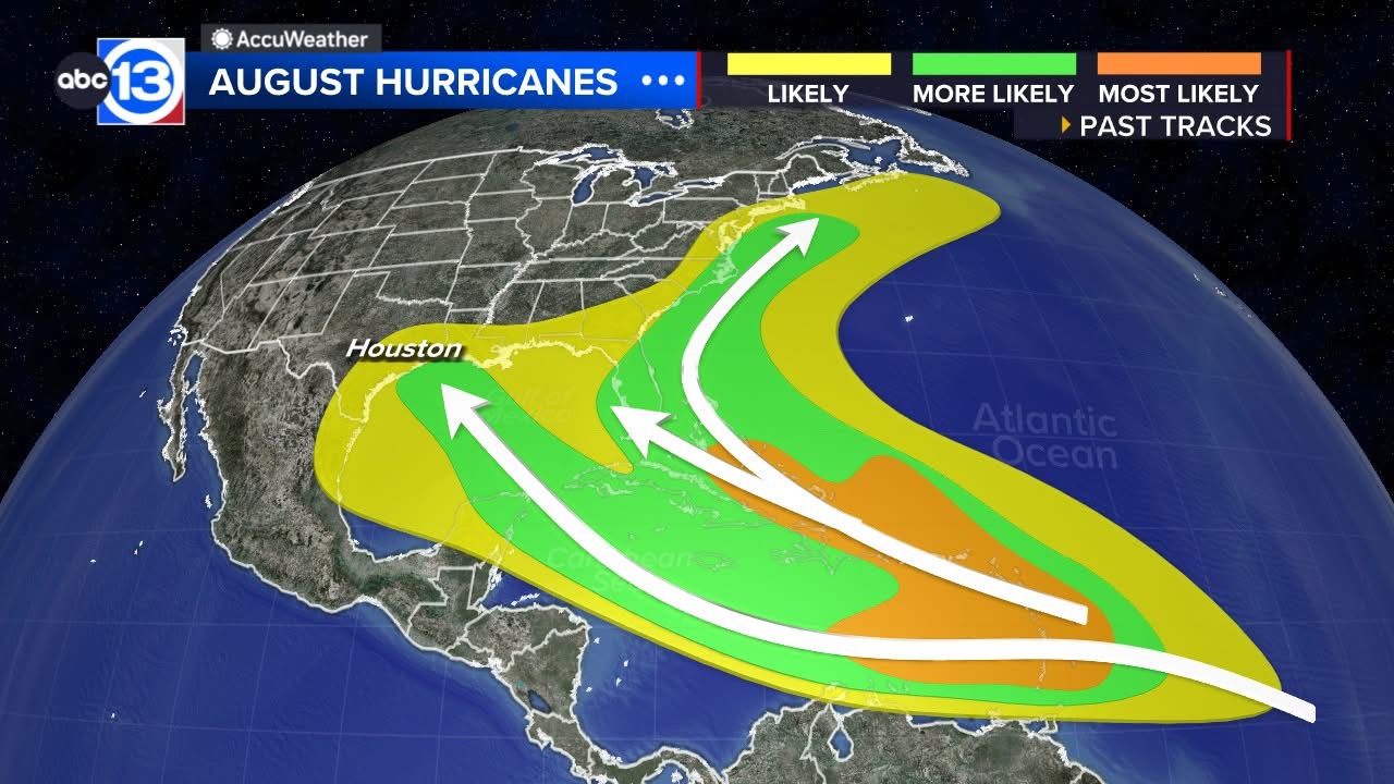
hmmm.. what up with this?
- Attachments
-
- Screenshot_20250817_094913_Chrome.jpg
- (908.71 KiB) Downloaded 8930 times
-
Pas_Bon
- Posts: 948
- Joined: Tue Sep 11, 2018 7:58 am
- Location: League City, TX
- Contact:
-
Stratton20
- Posts: 5814
- Joined: Tue Feb 09, 2021 11:35 pm
- Location: College Station, Texas
- Contact:
Lol folks over in storm2k are already writing our new lemonade wave off already, saying its going to recurve and not get into the gulf, I just dont get why people keep on saying stuff like that when we dont even have a developed system yet
-
sambucol
- Posts: 1244
- Joined: Wed Feb 03, 2010 5:43 pm
- Location: Mont Belvieu
- Contact:
Yep. But they do. It’s wise to write nothing off at this point.Stratton20 wrote: ↑Sun Aug 17, 2025 2:51 pm Lol folks over in storm2k are already writing our new lemonade wave off already, saying its going to recurve and not get into the gulf, I just dont get why people keep on saying stuff like that when we dont even have a developed system yet
-
Cpv17
- Posts: 7091
- Joined: Fri Aug 31, 2018 1:58 pm
- Location: El Campo/Wharton
- Contact:
We have about 5 weeks left of hurricane season for our area. I’m already losing interest in this next system. Time is starting to run out. Maybe we make it unscathed this year.
-
Stratton20
- Posts: 5814
- Joined: Tue Feb 09, 2021 11:35 pm
- Location: College Station, Texas
- Contact:
Cpv17 way too early to write off this system yet since nothing has formed and so much can change with the steering pattern being 10-12 days out, also 5 weeks left is a lot of time, this comment might not age well lol
-
DoctorMu

- Posts: 8016
- Joined: Sun Jun 28, 2015 11:58 am
- Location: College Station
- Contact:
It depends. That would take a cooling FROPA usually to turn the easterlies to westerlies. We've been in an easterly mode for awhile. If there's one thing that Texas weather knows how to do, it's getting stuck in a pattern.
Also, those 5 weeks or so are the peak.
-
Cpv17
- Posts: 7091
- Joined: Fri Aug 31, 2018 1:58 pm
- Location: El Campo/Wharton
- Contact:
Yeah, our season usually ends around the third week of September.DoctorMu wrote: ↑Sun Aug 17, 2025 5:47 pmIt depends. That would take a cooling FROPA usually to turn the easterlies to westerlies. We've been in an easterly mode for awhile. If there's one thing that Texas weather knows how to do, it's getting stuck in a pattern.
Also, those 5 weeks or so are the peak.
-
Cpv17
- Posts: 7091
- Joined: Fri Aug 31, 2018 1:58 pm
- Location: El Campo/Wharton
- Contact:
I was just talking about this next system lol I know 5 weeks left is a good while, especially when peak season is nearing. I’m just not currently as interested in this next system anymore as I once was. Very little ensemble support for anything in the Gulf.Stratton20 wrote: ↑Sun Aug 17, 2025 5:46 pm Cpv17 way too early to write off this system yet since nothing has formed and so much can change with the steering pattern being 10-12 days out, also 5 weeks left is a lot of time, this comment might not age well lol
-
Cpv17
- Posts: 7091
- Joined: Fri Aug 31, 2018 1:58 pm
- Location: El Campo/Wharton
- Contact:
We now have an orange for future 99L.
If it goes into the Caribbean and passes south of Puerto Rico, watch out Gulf coast. Most ensembles right now have it N of there though.
If it goes into the Caribbean and passes south of Puerto Rico, watch out Gulf coast. Most ensembles right now have it N of there though.
-
Cpv17
- Posts: 7091
- Joined: Fri Aug 31, 2018 1:58 pm
- Location: El Campo/Wharton
- Contact:
Of course every storm is different, but in general, this is how it works:
-
Ptarmigan

- Statistical Specialist

- Posts: 4519
- Joined: Wed Feb 03, 2010 7:20 pm
- Contact:
I would be also concerned of storms that form closer to land.
-
tireman4

- Global Moderator

- Posts: 7123
- Joined: Wed Feb 03, 2010 9:24 pm
- Location: Humble, Texas
- Contact:
In brief: Hurricane Erin will continue to impact the Turks and Caicos and southeast Bahamas today. It remains on course to head out to sea, but it's likely to cause significant impacts in the Outer Banks and widespread coastal flooding, beach erosion, and rip currents along the East Coast. Meanwhile, the next wave behind Erin is too early on to worry about, though it will be worth watching this week.
Can I just interject for a minute before we get into today's post? I must be a glutton for punishment, as my "new tabs" in Microsoft Edge show up with completely absurd news headlines. Though this time of year, it becomes more entertainment than anything. For example, according to the Irish Star:
Completely absurd headlines
Let's simply ignore the fact that the storms that will "batter Florida" are of the typical summertime variety, completely unrelated to Erin. Much to everyone's relief, I did read the article, and I still don't know what the "the worst" is that the experts fear. European tabloids are a contact sport, so I'd expect nothing less, but anyway, it's little things like this that justify The Eyewall's existence.
Hurricane Erin
Alright, onto the serious matter at hand, which is Hurricane Erin.
(NOAA/NHC)
Erin is back up to category 4 intensity this morning, with maximum sustained winds of 130 mph. It sits just north of the Turks and Caicos Islands. Erin has continued to grow in size since yesterday. The tropical storm-force wind field extends out 230 miles now. Hurricane-force winds have more than doubled in size, now extending out 80 miles from the center. This places Erin in the 80th percentile of major hurricanes in terms of size. In plain language: Bigger than usual.
A buoy about 150 miles northeast of Erin has been reporting wind gusts of 50 mph or better. (NOAA)
Erin remains a very formidable and growing hurricane. Tropical storm conditions will continue today in the southeast Bahamas and Turks and Caicos Islands, where Tropical Storm Warnings remain posted. A Tropical Storm Watch is now posted in the Central Bahamas.
Hurricane Erin emerges from nighttime this morning. (Weathernerds.org)
Erin is likely beginning another period of intensification this morning that may continue into this evening. After that, Erin will likely begin to feel some impacts of wind shear in the area that will slowly erode at its intensity. Erin should remain a category 3 or stronger hurricane through Wednesday, however.
For the southeastern Bahamas, Turks and Caicos, and Hispaniola, squally weather will continue today and tonight. By tomorrow, Erin should finally begin to move away, allowing conditions to improve some.
Beyond the Bahamas, Erin's track forecast has continued to nudge slightly westward, though not as much as it had this weekend. Erin will remain off the Southeast coast and split the difference between the Outer Banks and Bermuda on its way off to the north and eventually northeast.
Forecast maximum wind gusts on the North Carolina coast and Outer Banks midweek as Erin passes. (NWS Morehead City)
As Erin passes the Outer Banks, tropical storm-force wind gusts will be likely, perhaps approaching 50 mph just offshore. While those wind gusts will be a bit of a nuisance, they aren't anything too terrible for this area. However, the waves and rip currents will be a big problem. Based on the latest forecasts, this will be a prolonged event for the area with several days of difficult, if not impossible travel along NC-12 for Hatteras and Ocracoke Islands. Heed the advice of local officials in these areas.
Higher than normal tides, beach erosion, and powerful waves will create a very challenging situation on the Outer Banks this week. (NWS Morehead City)
Conditions should be at their worst late tomorrow into early Thursday before slowly easing up. Rip currents and rough surf will be a developing issue up and down the entire East Coast this week. Rip current statements are in place from West Palm Beach northward already. Basically, swimming won't be advisable, as even the strongest and best swimmers can't always overcome strong rip currents.
(NWS Mount Holly/Philadelphia)
Tidal flooding will also be an issue up and down the East Coast, with coastal flood advisories or statements posted as far north as Long Island.
Bottom line: Hurricane Erin will directly impact the Turks and Caicos Islands and Southeast Bahamas today. As Erin passes offshore, rip currents, rough surf, beach erosion, and tidal flooding will be a concern from as far south as Florida into the Carolinas into New England.
Eventually, some of these wave issues will make it to Atlantic Canada as well toward the weekend.
Next wave up
The next tropical disturbance is a nascent wave west of the Cabo Verde Islands.
The next tropical wave will make an attempt to organize later this week as it comes west across the Atlantic. (Weathernerds.org)
We have a ways to go here with this one, but I suspect we have an invest area out of this wave by tomorrow. The math on this is pretty simple, but deriving the equation is still very challenging. We know that a weaker tropical wave would probably continue west or west-northwest toward the Caribbean. Basically, if this doesn't do much in the way of developing, it will probably continue to sneak westward. Alternatively, if it develops quickly as it comes across, or at the speed of Erin's early organization, it would probably turn northwest and north and follow Erin out to sea. By the time we get to the weekend, we will see if this thing is farther south, closer to the islands, or more out into the open Atlantic, as most AI modeling seems to favor.
By the weekend, the next wave will be somewhere between the Caribbean and the open Atlantic, with a wide possibility of potential outcomes. AI modeling is skewed more to the north and east, while traditional ensembles are all over the map. (Google Weather Lab)
We have a long way to go with this one, but it's not currently worth worrying about. Just check in daily for updates. We'll keep you posted.
- Attachments
-
- Screenshot 2025-08-18 082834.png (198.03 KiB) Viewed 17172 times
-
- Screenshot 2025-08-18 083409.png (45.77 KiB) Viewed 17172 times
-
- Screenshot 2025-08-18 083434.png (239.51 KiB) Viewed 17172 times
-
- Screenshot 2025-08-18 083506.png (267.28 KiB) Viewed 17172 times
-
- Screenshot 2025-08-18 083532.png (267.28 KiB) Viewed 17172 times
-
- Screenshot 2025-08-18 083601.png (279.66 KiB) Viewed 17172 times
-
- Screenshot 2025-08-18 083629.png (203.04 KiB) Viewed 17172 times
-
- Screenshot 2025-08-18 083650.png (253.63 KiB) Viewed 17172 times
-
- Screenshot 2025-08-18 083717.png (89.63 KiB) Viewed 17172 times
-
tireman4
- Global Moderator
- Posts: 7123
- Joined: Wed Feb 03, 2010 9:24 pm
- Location: Humble, Texas
- Contact:
Erin
- Attachments
-
- Screenshot 2025-08-18 095507.jpg (77.11 KiB) Viewed 17150 times
-
tireman4
- Global Moderator
- Posts: 7123
- Joined: Wed Feb 03, 2010 9:24 pm
- Location: Humble, Texas
- Contact:
000
WTNT35 KNHC 181447
TCPAT5
BULLETIN
Hurricane Erin Advisory Number 29
NWS National Hurricane Center Miami FL AL052025
1100 AM EDT Mon Aug 18 2025
...ERIN STRENGTHENS...
...EXPECTED TO GROW EVEN LARGER...
SUMMARY OF 1100 AM EDT...1500 UTC...INFORMATION
-----------------------------------------------
LOCATION...23.1N 70.8W
ABOUT 110 MI...180 KM N OF GRAND TURK ISLAND
ABOUT 880 MI...1420 KM SSE OF CAPE HATTERAS NORTH CAROLINA
MAXIMUM SUSTAINED WINDS...140 MPH...220 KM/H
PRESENT MOVEMENT...WNW OR 300 DEGREES AT 10 MPH...17 KM/H
MINIMUM CENTRAL PRESSURE...935 MB...27.61 INCHES
WATCHES AND WARNINGS
--------------------
CHANGES WITH THIS ADVISORY:
None.
SUMMARY OF WATCHES AND WARNINGS IN EFFECT:
A Tropical Storm Warning is in effect for...
* Turks and Caicos Islands
* Southeast Bahamas
A Tropical Storm Watch is in effect for...
* Central Bahamas
A Tropical Storm Warning means that tropical storm conditions are
expected somewhere within the warning area.
A Tropical Storm Watch means that tropical storm conditions are
possible within the watch area, in this case within 12 to 24 hours.
Interests in the northwestern Bahamas, the North Carolina Outer
Banks, and Bermuda should monitor the progress of Erin.
For storm information specific to your area, please monitor
products issued by your national meteorological service.
DISCUSSION AND OUTLOOK
----------------------
At 1100 AM EDT (1500 UTC), the center of Hurricane Erin was located
near latitude 23.1 North, longitude 70.8 West. Erin is moving toward
the west-northwest near 10 mph (17 km/h). A turn to the northwest
is expected later today, followed by a turn to the north and on
Tuesday. On the forecast track, the core of Erin is expected to
pass to the east of the southeastern Bahamas today and move between
Bermuda and the east coast of the United States by the middle of the
week.
Maximum sustained winds have increased to near 140 mph (220 km/h)
with higher gusts. Erin is a category 4 hurricane on the
Saffir-Simpson Hurricane Wind Scale. Some additional strengthening
is expected today. Erin will remain a dangerous major hurricane
through the middle of this week.
Hurricane-force winds extend outward up to 80 miles (130 km) from
the center and tropical-storm-force winds extend outward up to 230
miles (370 km).
The minimum central pressure estimated from NOAA and Air
Force Reserve Hurricane Hunter observations is 935 mb (27.61
inches).
HAZARDS AFFECTING LAND
----------------------
Key messages for Erin can be found in the Tropical Cyclone
Discussion under AWIPS header MIATCDAT5 and WMO header WTNT45 KNHC.
RAINFALL: Outer bands of Erin will produce localized areas of heavy
rainfall across portions of Hispaniola through today and through
Tuesday for the Turks and Caicos and the Bahamas east from San
Salvador Island. Additional rainfall of 2 to 4 inches, with
locally higher amounts to 6 inches, are forecast.
For a complete depiction of forecast rainfall and flash flooding
associated with Erin, please see the National Weather Service Storm
Total Rainfall Graphic, available at
hurricanes.gov/graphics_at5.shtml?rainqpf
For a complete depiction of forecast rainfall and flash flooding
associated with Erin, please see the National Weather Service Storm
Total Rainfall Graphic, available at
hurricanes.gov/graphics_at5.shtml?rainqpf
WIND: Tropical storm conditions are expected today across the Turks
and Caicos Islands and the southeast Bahamas. Tropical storm
conditions are possible in portions of the central Bahamas late
today through Tuesday.
SURF: Swells generated by Erin will affect the Bahamas, Bermuda,
the east coast of the United States, and Atlantic Canada during the
next several days. These rough ocean conditions will likely cause
life-threatening surf and rip currents. Please consult products
from your local weather forecast office for more information.
A depiction of rip current risk for the United States can be found
at: hurricanes.gov/graphics_at5.shtml?ripCurrents
STORM SURGE: Minor coastal flooding is possible in areas of
onshore winds in the Turks and Caicos Islands and the southeast
Bahamas. Near the coast, the surge will be accompanied by large
waves.
NEXT ADVISORY
-------------
Next intermediate advisory at 200 PM EDT.
Next complete advisory at 500 PM EDT.
$$
Forecaster Pasch/Roberts
-
tireman4
- Global Moderator
- Posts: 7123
- Joined: Wed Feb 03, 2010 9:24 pm
- Location: Humble, Texas
- Contact:
000
ABNT20 KNHC 181131
TWOAT
Tropical Weather Outlook
NWS National Hurricane Center Miami FL
800 AM EDT Mon Aug 18 2025
For the North Atlantic...Caribbean Sea and the Gulf of America:
Active Systems:
The National Hurricane Center is issuing advisories on Hurricane
Erin, located a little over 100 miles north-northeast of Grand Turk
Island.
Tropical Atlantic:
A tropical wave located over the eastern tropical Atlantic is
producing disorganized showers and thunderstorms. Environmental
conditions appear conducive for gradual development of this system,
and a tropical depression could form during the latter part of the
week. This system should move westward to west-northwestward at
about 20 mph across the central tropical Atlantic and approach the
vicinity of the Leeward Islands toward the end of the week.
* Formation chance through 48 hours...low...near 0 percent.
* Formation chance through 7 days...medium...50 percent.
$$
Forecaster Roberts
-
tireman4
- Global Moderator
- Posts: 7123
- Joined: Wed Feb 03, 2010 9:24 pm
- Location: Humble, Texas
- Contact:
Bob Harlem at S2K
- Attachments
-
- Bob Harlem.png
- (570.4 KiB) Downloaded 8553 times
-
tireman4
- Global Moderator
- Posts: 7123
- Joined: Wed Feb 03, 2010 9:24 pm
- Location: Humble, Texas
- Contact:
000
WTNT35 KNHC 181749
TCPAT5
BULLETIN
Hurricane Erin Intermediate Advisory Number 29A
NWS National Hurricane Center Miami FL AL052025
200 PM EDT Mon Aug 18 2025
...ERIN LIKELY TO BECOME EVEN LARGER OVER THE COMING DAYS...
SUMMARY OF 200 PM EDT...1800 UTC...INFORMATION
----------------------------------------------
LOCATION...23.5N 71.1W
ABOUT 140 MI...220 KM N OF GRAND TURK ISLAND
ABOUT 850 MI...1370 KM SSE OF CAPE HATTERAS NORTH CAROLINA
MAXIMUM SUSTAINED WINDS...140 MPH...220 KM/H
PRESENT MOVEMENT...WNW OR 300 DEGREES AT 10 MPH...17 KM/H
MINIMUM CENTRAL PRESSURE...937 MB...27.67 INCHES
WATCHES AND WARNINGS
--------------------
CHANGES WITH THIS ADVISORY:
None.
SUMMARY OF WATCHES AND WARNINGS IN EFFECT:
A Tropical Storm Warning is in effect for...
* Turks and Caicos Islands
* Southeast Bahamas
A Tropical Storm Watch is in effect for...
* Central Bahamas
A Tropical Storm Warning means that tropical storm conditions are
expected somewhere within the warning area.
A Tropical Storm Watch means that tropical storm conditions are
possible within the watch area, in this case within 12 to 24 hours.
Interests in the northwestern Bahamas, the North Carolina Outer
Banks, and Bermuda should monitor the progress of Erin.
For storm information specific to your area, please monitor
products issued by your national meteorological service.
DISCUSSION AND OUTLOOK
----------------------
At 200 PM EDT (1800 UTC), the center of Hurricane Erin was located
near latitude 23.5 North, longitude 71.1 West. Erin is moving toward
the west-northwest near 10 mph (17 km/h). A turn to the northwest
is expected later today, followed by a turn to the north on
Tuesday. On the forecast track, the core of Erin is expected to
pass to the east of the southeastern Bahamas today and move between
Bermuda and the east coast of the United States by the middle of
the week.
Maximum sustained winds are near 140 mph (220 km/h) with higher
gusts. Erin is a category 4 hurricane on the Saffir-Simpson
Hurricane Wind Scale. Some additional strengthening is possible
today. Erin is likely to remain a dangerous major hurricane
through the middle of this week.
Hurricane-force winds extend outward up to 80 miles (130 km) from
the center and tropical-storm-force winds extend outward up to 230
miles (370 km).
The estimated minimum central pressure is 937 mb (27.67 inches).
HAZARDS AFFECTING LAND
----------------------
Key messages for Erin can be found in the Tropical Cyclone
Discussion under AWIPS header MIATCDAT5 and WMO header WTNT45 KNHC.
RAINFALL: Outer bands of Erin will produce localized areas of heavy
rainfall across portions of Hispaniola through today and through
Tuesday for the Turks and Caicos and the Bahamas east from San
Salvador Island. Additional rainfall of 2 to 4 inches, with
locally higher amounts to 6 inches, are forecast.
For a complete depiction of forecast rainfall and flash flooding
associated with Erin, please see the National Weather Service Storm
Total Rainfall Graphic, available at
hurricanes.gov/graphics_at5.shtml?rainqpf
For a complete depiction of forecast rainfall and flash flooding
associated with Erin, please see the National Weather Service Storm
Total Rainfall Graphic, available at
hurricanes.gov/graphics_at5.shtml?rainqpf
WIND: Tropical storm conditions are expected today across the Turks
and Caicos Islands and the southeast Bahamas. Tropical storm
conditions are possible in portions of the central Bahamas late
today through Tuesday.
SURF: Swells generated by Erin will affect the Bahamas, Bermuda,
the east coast of the United States, and Atlantic Canada during the
next several days. These rough ocean conditions will likely cause
life-threatening surf and rip currents. Please consult products
from your local weather forecast office for more information.
A depiction of rip current risk for the United States can be found
at: hurricanes.gov/graphics_at5.shtml?ripCurrents
STORM SURGE: Minor coastal flooding is possible in areas of
onshore winds in the Turks and Caicos Islands and the southeast
Bahamas. Near the coast, the surge will be accompanied by large
waves.
NEXT ADVISORY
-------------
Next complete advisory at 500 PM EDT.
$$
Forecaster Pasch