
July 2025
-
srainhoutx

- Site Admin

- Posts: 19700
- Joined: Tue Feb 02, 2010 2:32 pm
- Location: Maggie Valley, NC
- Contact:
We are following closely here in Western North Carolina. It brings back so many bad memories of late last September as Helene impacted this Region. I recall the 1987 flood event for Kerr County. I am so devastated that so many young people have been impacted. How many times have warm cored remnant low of dying tropical systems brought devastating impacts in Texas and particularly the Hill Country?
Carla/Alicia/Jerry(In The Eye)/Michelle/Charley/Ivan/Dennis/Katrina/Rita/Wilma/Humberto/Ike/Harvey
Member: National Weather Association
Facebook.com/Weather Infinity
Twitter @WeatherInfinity
Member: National Weather Association
Facebook.com/Weather Infinity
Twitter @WeatherInfinity
-
Ptarmigan

- Statistical Specialist

- Posts: 4536
- Joined: Wed Feb 03, 2010 7:20 pm
- Contact:
I know hurricane remnants and warm core low pressures have caused heavy rain and flooding. Most of these flood events happen at night, usually after midnight.srainhoutx wrote: ↑Fri Jul 04, 2025 8:52 pm We are following closely here in Western North Carolina. It brings back so many bad memories of late last September as Helene impacted this Region. I recall the 1987 flood event for Kerr County. I am so devastated that so many young people have been impacted. How many times have warm cored remnant low of dying tropical systems brought devastating impacts in Texas and particularly the Hill Country?
Central Texas Flooding, Including Hill Country
June 1899-Tropical Storm 1
September 1921-Hurricane 2
September 1932-Warm Core Low Pressure?
September 1936-Tropical Storm 14
June 1954-Hurricane Alice (Deep South Texas Event)
September 1967-Hurricane Beulah (Deep South Texas Event)
August 1978-Tropical Storm Amelia
July 2002-Warm Core Low Pressure
September 2010-Tropical Storm Hermine
July 2025-Tropical Storm Barry
https://www.weather.gov/sjt/events-1936 ... d%20houses.
https://www.weather.gov/media/lch/event ... istory.pdf
https://cdn.ymaws.com/www.tfma.org/reso ... ellano.pdf
https://pubs.usgs.gov/wsp/0488/report.pdf
https://pubs.usgs.gov/wsp/0816/report.pdf
https://pubs.usgs.gov/of/2003/ofr03-193 ... patton.htm
https://dailytimes.com/history/a-remind ... ae569.html
-
TexasBreeze
- Posts: 1029
- Joined: Sun Sep 26, 2010 4:46 pm
- Location: NW Houston, TX
- Contact:
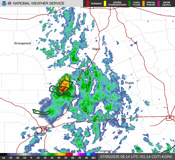
That cell to the northwest of Austin may be the beginning of tonight's activity? It is a slow moving and strong storm.
-
Cpv17
- Posts: 7109
- Joined: Fri Aug 31, 2018 1:58 pm
- Location: El Campo/Wharton
- Contact:
I think that’s possible, but the mesos aren’t really showing much happening tonight.TexasBreeze wrote: ↑Fri Jul 04, 2025 11:34 pm That cell to the northwest of Austin may be the beginning of tonight's activity? It is a slow moving and strong storm.
-
tireman4

- Global Moderator

- Posts: 7161
- Joined: Wed Feb 03, 2010 9:24 pm
- Location: Humble, Texas
- Contact:
Today's Forecast ( although the moisture from the West is slowly matriculating eastward)
- Attachments
-
- KEWX_loop-3.gif (868.12 KiB) Viewed 5182 times
-
- hgx.png (42.3 KiB) Viewed 5198 times
-
- 3.png
- (1.7 MiB) Downloaded 1653 times
-
tireman4
- Global Moderator
- Posts: 7161
- Joined: Wed Feb 03, 2010 9:24 pm
- Location: Humble, Texas
- Contact:
WPC Update
- Attachments
-
- GvFZUFaXMAEVOAH.jpeg (54.6 KiB) Viewed 5172 times
-
Cromagnum
- Posts: 3076
- Joined: Thu Feb 03, 2011 10:42 pm
- Location: Georgetown
- Contact:
Warm core event? 16 inches of rain fell in that spot overnight.Cpv17 wrote: ↑Fri Jul 04, 2025 11:42 pmI think that’s possible, but the mesos aren’t really showing much happening tonight.TexasBreeze wrote: ↑Fri Jul 04, 2025 11:34 pm That cell to the northwest of Austin may be the beginning of tonight's activity? It is a slow moving and strong storm.
-
Cpv17
- Posts: 7109
- Joined: Fri Aug 31, 2018 1:58 pm
- Location: El Campo/Wharton
- Contact:
That’s why I said it’s possible. Mesos didn’t have that happening when I looked around 10-11pm last night though. And that’s why I said yesterday that I would expect it to blow up again overnight if it’s a warm core event.Cromagnum wrote: ↑Sat Jul 05, 2025 9:01 amWarm core event? 16 inches of rain fell in that spot overnight.Cpv17 wrote: ↑Fri Jul 04, 2025 11:42 pmI think that’s possible, but the mesos aren’t really showing much happening tonight.TexasBreeze wrote: ↑Fri Jul 04, 2025 11:34 pm That cell to the northwest of Austin may be the beginning of tonight's activity? It is a slow moving and strong storm.
-
don

- Posts: 3148
- Joined: Wed Feb 03, 2010 3:33 pm
- Location: Wichita Falls
- Contact:
This is a "classic" core rain event from a warm core low. Big droughts love to end in floods down here. A very dangerous situation.My heart goes out to all those impacted and those lost or still missing.
-
Stratton20
- Posts: 5870
- Joined: Tue Feb 09, 2021 11:35 pm
- Location: College Station, Texas
- Contact:
Id be fine with not seeing anymore rain the rest of the month, just absolutely devastating for central texas folks, one of the worst flooding disasters in many years, I wouldnt mind a big heat dome setting up shop over the state, get that rain out of texas!
-
Cpv17
- Posts: 7109
- Joined: Fri Aug 31, 2018 1:58 pm
- Location: El Campo/Wharton
- Contact:
Most areas in Texas haven’t even seen much. Just the Hill Country and some parts of CTX.Stratton20 wrote: ↑Sat Jul 05, 2025 12:05 pm Id be fine with not seeing anymore rain the rest of the month, just absolutely devastating for central texas folks, one of the worst flooding disasters in many years, I wouldnt mind a big heat dome setting up shop over the state, get that rain out of texas!
-
MontgomeryCoWx

- Posts: 2753
- Joined: Wed Dec 14, 2011 4:31 pm
- Location: Weimar, TX
- Contact:
Unnecessariy overreaction. We need a lot more in CoCo. Yeah, I hope the Hill Country dries out. You can have bothStratton20 wrote: ↑Sat Jul 05, 2025 12:05 pm Id be fine with not seeing anymore rain the rest of the month, just absolutely devastating for central texas folks, one of the worst flooding disasters in many years, I wouldnt mind a big heat dome setting up shop over the state, get that rain out of texas!
Team #NeverSummer
-
Stratton20
- Posts: 5870
- Joined: Tue Feb 09, 2021 11:35 pm
- Location: College Station, Texas
- Contact:
Just my opinion , ive seen probably close to a foot and a half of rain over the last 1-2 months, cant even mow the lawn because the grass is still soggy, mosquitoes have been about as bad as it can get, i personally wouldn’t mind a couple weeks of dry weather
-
tireman4
- Global Moderator
- Posts: 7161
- Joined: Wed Feb 03, 2010 9:24 pm
- Location: Humble, Texas
- Contact:
Jeff Lindner
- Attachments
-
- FB_IMG_1751739270690.jpg
- (54.6 KiB) Downloaded 1473 times
-
DoctorMu

- Posts: 8089
- Joined: Sun Jun 28, 2015 11:58 am
- Location: College Station
- Contact:
1994 EPAC moisture from Rosa crushed us in SETX. We had 18 inches of rain in 18 hours, filling the backyard with water. I had to knockdown the fence to let water out.srainhoutx wrote: ↑Fri Jul 04, 2025 8:52 pm We are following closely here in Western North Carolina. It brings back so many bad memories of late last September as Helene impacted this Region. I recall the 1987 flood event for Kerr County. I am so devastated that so many young people have been impacted. How many times have warm cored remnant low of dying tropical systems brought devastating impacts in Texas and particularly the Hill Country?
A cell just hit here. It is coming down.
-
DoctorMu
- Posts: 8089
- Joined: Sun Jun 28, 2015 11:58 am
- Location: College Station
- Contact:
Flash flood warnings all over the Austin and San Antonio area.
That low *barely* moved east overnight. Incredible flooding. Even with the Hill Country dam and lake systems in place.
That low *barely* moved east overnight. Incredible flooding. Even with the Hill Country dam and lake systems in place.
-
DoctorMu
- Posts: 8089
- Joined: Sun Jun 28, 2015 11:58 am
- Location: College Station
- Contact:
You have to be careful what you wish for. We had 50 inches of rain last year through Beryl. Then it stopped raining through early December. And one of our hottest early and mid Falls. The late drought killed a lot of backyard grass and bushes. The trees fortunately managed to make it.MontgomeryCoWx wrote: ↑Sat Jul 05, 2025 12:18 pmUnnecessariy overreaction. We need a lot more in CoCo. Yeah, I hope the Hill Country dries out. You can have bothStratton20 wrote: ↑Sat Jul 05, 2025 12:05 pm Id be fine with not seeing anymore rain the rest of the month, just absolutely devastating for central texas folks, one of the worst flooding disasters in many years, I wouldnt mind a big heat dome setting up shop over the state, get that rain out of texas!
-
DoctorMu
- Posts: 8089
- Joined: Sun Jun 28, 2015 11:58 am
- Location: College Station
- Contact:
NWS really appears to be struggling with the forecast. NWS has a 40% chance of rain. We're 60% beyond that - looks like rain all afternoon. Problems with sufficient staffing? Warm core low trickiness?
Area Forecast Discussion
National Weather Service Houston/Galveston TX
1238 PM CDT Sat Jul 5 2025
.KEY MESSAGES...
Issued at 1237 PM CDT Sat Jul 5 2025
- Scattered showers with a few thunderstorms will continue to
today, mostly west of I-45.
- The next best chance for rain and storms returns Monday and
Tuesday with the arrival of a disturbance from the east.
- Temperatures are forecast to trend upward towards the second
half of the week. But some uncertainty exists with the forecast
beyond Wednesday.
&&
.DISCUSSION...
Issued at 1136 AM CDT Sat Jul 5 2025
The quasi-stationary mid-level disturbance that has brought very
heavy rainfall to portions of Central Texas continues to have an
effect on our local atmosphere today. Scattered showers and
isolated thunderstorms have already developed across our western
counties, producing locally heavy downpours in the Brazos Valley.
Shower and thunderstorm coverage is expected to expand eastward as
daytime heating provides added instability. Not everyone will
receive rain. But some communities are likely to experience heavy
downpours along with some thunder and lighting. Best chance of
showers and thunderstorms will be west of I-45. But isolated
activity to the east of I-45 is possible as well. These showers
and storms are expected to decrease in coverage as we lose daytime
heating this evening. The aforementioned system is drifting
slowly southward and is expected to be far enough away from the
area to not enhance atmospheric lift by Sunday. In addition, lower
PWATs are expected to filter into the area from the east.
Therefore, the chance / coverage of showers and thunderstorms is
expected to be lower. That being said, day time heating coupled
with the sea breeze and sufficient moisture could still spark off
isolated showers and thunderstorms.
Our attention will turn east as we finally get rid of the current
system over Central Texas. Middle and upper level water vapor
imagery coupled with the current 500MB RAP analysis show a clear
mid/upper trough over the eastern Gulf. This trough will drift
westward over the next couple of days, influencing the SE Texas
atmosphere by Monday and Tuesday. The added lift on top of the
typically high July PWATs would tend to enhance the convective
initiation potential from the sea breeze / bay breeze as well as
other mesoscale processes that interact with the heating of the
day. Model guidance isn`t very consistent regarding rainfall
coverage. But a mid/upper low moving into Texas from the Gulf is
usually, at a minimum, an enhancer of the summertime diurnal
convective cycle. The best chance of showers and thunderstorms on
Monday and Tuesday is across our southern and eastern counties.
Beyond Tuesday, computer models continue to insist on a hotter and
less rainy pattern. Increasingly robust and suppressive ridging is
pretty normal as we head deeper into July. Our forecast for
Wednesday-Friday features hotter temperatures and lower PoPs. But
we are keeping a daily risk of showers and thunderstorms through
the end of the week. This is in part due to the fact that long
term guidance has had a recent dry bias. In addition, there are
already some signals in the guidance showing how the forecast
could become wetter later in the wake. Despite the general
increase in ridging, global models are hinting at a potential
weakness in the ridge sneaking its way southwest from the Midwest
to the Arklatex region on Thursday and Friday. Current
Thursday/Friday PoPs are low. But those PoPs will have to increase
if the trough can extend a little farther south and west. And
even if it doesn`t, enhanced convection to our north and east can
sometimes have a mesoscale ripple effect that can turn a dry
forecast into a wet one.
Temperature wise, we expect highs to average in the low/mid 90s
through Wednesday, then mid/upper 90s by Thursday and Friday. But
those hotter temperatures will be dependent on whether or not
ridging continues to build or not. The humidity will remain quite
fierce. So peak daily heat index values are likely to remain in
the triple digits. Drink your water y`all!
&&
-
DoctorMu
- Posts: 8089
- Joined: Sun Jun 28, 2015 11:58 am
- Location: College Station
- Contact:
Euro and Euro-AI see cooler and cloudier/some rain forecast over the next 14 days compared with scorching GFS. CMC is in the middle. GFS and NWS have had a rough year in forecasting. Fingers crossed the Euro is onto something.
-
Cpv17
- Posts: 7109
- Joined: Fri Aug 31, 2018 1:58 pm
- Location: El Campo/Wharton
- Contact:
Mesos are pretty much useless right now. This is a very tricky forecast.