
Do we have anything to look forward to
December-Wet/Stormy New Years Eve Ahead
-
txflagwaver

- Posts: 411
- Joined: Wed Feb 03, 2010 2:37 pm
- Location: Seabrook/Kemah
- Contact:
Well...we know Thanksgiving is going to be a bust as far as cold weather goes.
Do we have anything to look forward to Are we going to have Winter
Do we have anything to look forward to
-
srainhoutx

- Site Admin

- Posts: 19700
- Joined: Tue Feb 02, 2010 2:32 pm
- Location: Maggie Valley, NC
- Contact:
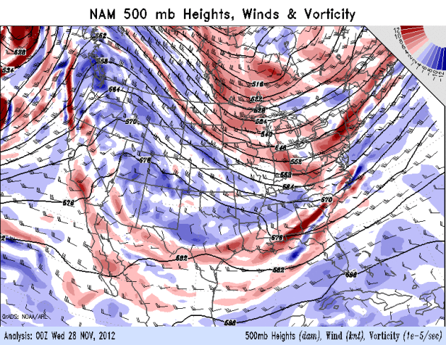
There are 'hints' of a big pattern change showing up via the long range guidance and the 12Z Euro is beginning to sniff out that pattern change as we head toward the last week of November/early December. There is a lot of chatter concerning a fairly significant cold snap around the first week of December. As mentioned in the November thread, a cross polar flow and significant increase in snow cover in our source regions of NW Canada and Siberia with a splitting Polar Vortex dropping S into Canada could bring that building cold air S into the Lower 48 into areas E of the Rockies. That said the zonal split flow of late does appear to be on its last leg once we get beyond Thanksgiving. We will see.
- Attachments
-
-
Carla/Alicia/Jerry(In The Eye)/Michelle/Charley/Ivan/Dennis/Katrina/Rita/Wilma/Humberto/Ike/Harvey
Member: National Weather Association
Facebook.com/Weather Infinity
Twitter @WeatherInfinity
Member: National Weather Association
Facebook.com/Weather Infinity
Twitter @WeatherInfinity
-
srainhoutx
- Site Admin
- Posts: 19700
- Joined: Tue Feb 02, 2010 2:32 pm
- Location: Maggie Valley, NC
- Contact:
While this is still way out in the 12Z GFS Operational la la land, it does give a hint of some potential near first week of December. We will see.
Carla/Alicia/Jerry(In The Eye)/Michelle/Charley/Ivan/Dennis/Katrina/Rita/Wilma/Humberto/Ike/Harvey
Member: National Weather Association
Facebook.com/Weather Infinity
Twitter @WeatherInfinity
Member: National Weather Association
Facebook.com/Weather Infinity
Twitter @WeatherInfinity
-
srainhoutx
- Site Admin
- Posts: 19700
- Joined: Tue Feb 02, 2010 2:32 pm
- Location: Maggie Valley, NC
- Contact:
Just so everyone has something to dream about when it's warm on Thangiving Day... 

- Attachments
-
Carla/Alicia/Jerry(In The Eye)/Michelle/Charley/Ivan/Dennis/Katrina/Rita/Wilma/Humberto/Ike/Harvey
Member: National Weather Association
Facebook.com/Weather Infinity
Twitter @WeatherInfinity
Member: National Weather Association
Facebook.com/Weather Infinity
Twitter @WeatherInfinity
-
srainhoutx
- Site Admin
- Posts: 19700
- Joined: Tue Feb 02, 2010 2:32 pm
- Location: Maggie Valley, NC
- Contact:
After several day of flip flopping via all the operational guidance and the cold air staying put across Canada, some changes are still brewing as we look to December. The Pacific has not been cooperating, but a more favorable pattern for the cold weather lovers appear to be in the works. It is very common for the GFS and the Euro to become 'confused' and send mixed signals. Some of the pattern 'drivers' this year are already beginning to develop. We are seeing some warming of the stratosphere across the Polar Regions and the polar vortex will likely split. Of course we do not know exactly where the polar vortex will set up shop over Canada after that split, but there are strong indications of a tanking NAO or Greenland Blocking ridge of high pressure that may move E toward the Davis Straights. Also a more favorable MJO appears to be shaping up next week which in time tends to develop a +PNA ridge in the NE Pacific. If we see that active MJO progress E, then the sub tropic jet becomes more active as increased convection migrates toward the Western Mexican Coast. The very long range operations GFS has been hinting of this pattern so that will be something to watch in the coming week. We have to remember that climo suggests our first freeze usually happens near the 8th of December. Hopefully we will begin to see some storminess develop to our W and increase the moisture across the Lone Star State in the weeks ahead. Fingers crossed that with some luck and a good pattern we won't have to wait too much longer for the chatter to pick up and we'll move beyond this rather quiet/boring weather stretch we have been in since September.
- Attachments
-
Carla/Alicia/Jerry(In The Eye)/Michelle/Charley/Ivan/Dennis/Katrina/Rita/Wilma/Humberto/Ike/Harvey
Member: National Weather Association
Facebook.com/Weather Infinity
Twitter @WeatherInfinity
Member: National Weather Association
Facebook.com/Weather Infinity
Twitter @WeatherInfinity
-
wxman57

- Global Moderator

- Posts: 2621
- Joined: Thu Feb 04, 2010 5:34 am
- Location: Southwest Houston (Westbury)
- Contact:
The first week or so of December is looking pretty good as far as I can see - no evidence of any extreme cold in our area, though the models are indicating building cold in western Canada.
-
srainhoutx
- Site Admin
- Posts: 19700
- Joined: Tue Feb 02, 2010 2:32 pm
- Location: Maggie Valley, NC
- Contact:
Nice storm brewing across the Plains the first week of December via the 12Z GFS output. Also noting a +PNA developing that continues to build and a very deep Central US trough showing up in the long range as well. Interesting to see the GFS trending 'wetter' over that past couple of days.
Carla/Alicia/Jerry(In The Eye)/Michelle/Charley/Ivan/Dennis/Katrina/Rita/Wilma/Humberto/Ike/Harvey
Member: National Weather Association
Facebook.com/Weather Infinity
Twitter @WeatherInfinity
Member: National Weather Association
Facebook.com/Weather Infinity
Twitter @WeatherInfinity
-
srainhoutx
- Site Admin
- Posts: 19700
- Joined: Tue Feb 02, 2010 2:32 pm
- Location: Maggie Valley, NC
- Contact:
The first week or so of December is looking a bit warmish but there are some fairly good hints that the zonal flow and the flood of moisture over the Pacific will be ending. The long range GFS has been sniffing a Pacific Ridge building and a rather impressive dome of Arctic High Pressure (near 1050+) developing near the Arctic. Perhaps a piece of that cold Arctic air will break off and head S during the second week of December near the 12th, +/- a couple of days. We will see.
- Attachments
-
Carla/Alicia/Jerry(In The Eye)/Michelle/Charley/Ivan/Dennis/Katrina/Rita/Wilma/Humberto/Ike/Harvey
Member: National Weather Association
Facebook.com/Weather Infinity
Twitter @WeatherInfinity
Member: National Weather Association
Facebook.com/Weather Infinity
Twitter @WeatherInfinity
-
Belmer

- Global Moderator
- Posts: 745
- Joined: Thu Jan 06, 2011 7:29 pm
- Location: Dallas, TX
- Contact:
I just can't trust it, Srain! I will take it three days at a time, not more than that. Models seemed to go crazy on cold air for the end of November to early part of December and now reality is that highs will be in the mid to upper 70s, even approaching 80s by the first of next week. Now we will have to wait till mid December to possibly get our shot of cold air? Nope. Just not buying it.
This could be because Joe Bastardi had to speak up in October saying, "November will be the coldest month across the U.S. in quite some time". Well that obviously didn't happen. Last week he mentioned on twitter that, "Hope everyone is ready for a very cold month of December across the mid and eastern US".
Of course, take those quotes how you want. They weren't word for word like that. But pretty darn close. I need to stop listening to that man!
Blake
Boomer Sooner
Boomer Sooner
-
srainhoutx
- Site Admin
- Posts: 19700
- Joined: Tue Feb 02, 2010 2:32 pm
- Location: Maggie Valley, NC
- Contact:
Belmer wrote:I just can't trust it, Srain! I will take it three days at a time, not more than that. Models seemed to go crazy on cold air for the end of November to early part of December and now reality is that highs will be in the mid to upper 70s, even approaching 80s by the first of next week. Now we will have to wait till mid December to possibly get our shot of cold air? Nope. Just not buying it.
This could be because Joe Bastardi had to speak up in October saying, "November will be the coldest month across the U.S. in quite some time". Well that obviously didn't happen. Last week he mentioned on twitter that, "Hope everyone is ready for a very cold month of December across the mid and eastern US".
Of course, take those quotes how you want. They weren't word for word like that. But pretty darn close. I need to stop listening to that man!
That's a wise approach. As we have seen this year alone, many a forecaster has eaten a lot of 'crow' whether it is was long range forecasting of cold/wintry weather/rain/tropics/...etc...
- Attachments
-
Carla/Alicia/Jerry(In The Eye)/Michelle/Charley/Ivan/Dennis/Katrina/Rita/Wilma/Humberto/Ike/Harvey
Member: National Weather Association
Facebook.com/Weather Infinity
Twitter @WeatherInfinity
Member: National Weather Association
Facebook.com/Weather Infinity
Twitter @WeatherInfinity
-
unome
- Posts: 3062
- Joined: Fri Feb 12, 2010 6:11 pm
From WeatherNation blog: http://blog.weathernationtv.com/2012/11 ... ationwide/#
just a bit of it:
First Week of December Will Feel Like October, Nationwide
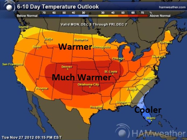
December On Hold. The 6-10 day temperature trends show temperatures well above average across most of the USA, thanks to a persistent wind flow from the Pacific – Canadian air temporarily bottled up in Canada. Map above: NOAA CPC and Ham Weather.
Zonal Flow. Typical for late September or mid-October, a (persistent – vigorous) west to east wind flow from the Pacific is a bit more unusual heading into the first week of December. The NOAA animation above shows 500 mb winds (18,000 feet) thru Saturday.
NAEFS Guidance. Experimental long-range guidance for December 5 – 11 shows a continuing block, keeping Alaska bitter, with mild Pacific winds pumping 40s, 50s and 60s into the Lower 48 states.
just a bit of it:
First Week of December Will Feel Like October, Nationwide
December On Hold. The 6-10 day temperature trends show temperatures well above average across most of the USA, thanks to a persistent wind flow from the Pacific – Canadian air temporarily bottled up in Canada. Map above: NOAA CPC and Ham Weather.
Zonal Flow. Typical for late September or mid-October, a (persistent – vigorous) west to east wind flow from the Pacific is a bit more unusual heading into the first week of December. The NOAA animation above shows 500 mb winds (18,000 feet) thru Saturday.
NAEFS Guidance. Experimental long-range guidance for December 5 – 11 shows a continuing block, keeping Alaska bitter, with mild Pacific winds pumping 40s, 50s and 60s into the Lower 48 states.
-
srainhoutx
- Site Admin
- Posts: 19700
- Joined: Tue Feb 02, 2010 2:32 pm
- Location: Maggie Valley, NC
- Contact:
Enjoy this upcoming pattern while it lasts. Big changes are brewing for mid December time range and it could bring moisture with it as well. The longer range guidance suggests an active storm track dipping very far S with building snow cover across the Rockies and all the Plains. It appears the sub tropical jet may become involved as well as moisture surges over some very chilly air at the surface just to our N near the 10th - 12th +/- a couple of days. I suspect that A_Z complaining will turn to Mister Heat Miser wxman57 shivering before all is said and done...
Carla/Alicia/Jerry(In The Eye)/Michelle/Charley/Ivan/Dennis/Katrina/Rita/Wilma/Humberto/Ike/Harvey
Member: National Weather Association
Facebook.com/Weather Infinity
Twitter @WeatherInfinity
Member: National Weather Association
Facebook.com/Weather Infinity
Twitter @WeatherInfinity
-
srainhoutx
- Site Admin
- Posts: 19700
- Joined: Tue Feb 02, 2010 2:32 pm
- Location: Maggie Valley, NC
- Contact:
Another issue we may have to watch is all that moisture streaming inland from the W Coast and attending storm system. The HPC is already making mention of that in their Extended Range Discussion this morning for next Tuesday/Wednesday for our part of the world as well as the SPC...
PRELIMINARY EXTENDED FORECAST DISCUSSION
NWS HYDROMETEOROLOGICAL PREDICTION CENTER COLLEGE PARK MD
331 AM EST WED NOV 28 2012
VALID 12Z SUN DEC 02 2012 - 12Z WED DEC 05 2012
==============================================================
= VERY WET PATTERN FOR NORTHERN CALIFORNIA WINDS DOWN SUNDAY =
= RENEWED HEAVY PRECIPITATION FOR THE NORTHWEST NEXT TUE/WED =
==============================================================
GENERAL FLOW PATTERN/MODEL PREFERENCE
=====================================
THE GENERAL FLOW PATTERN IS CONTROLLED BY A QUASI-STATIONARY POLAR
VORTEX OVER NUNAVUT AND A POSITIVE MID-LEVEL HEIGHT ANOMALY ACROSS
EASTERN SIBERIA AND THE BERING SEA. RENEWED TROUGHING ACROSS THE
EASTERN PACIFIC COMBINED WITH THE POLAR VORTEX ACROSS NORTHERN
CANADA ESCORTS AN AMPLIFIED LONGWAVE TROUGH THROUGH THE WESTERN
AND CENTRAL UNITED STATES WITH TIME. THE GUIDANCE IS IN
EXCEPTIONALLY GOOD AGREEMENT, INCLUDING THE GEFS/ECMWF ENSEMBLE
MEANS. AS SUCH, THE PRESSURES WERE BASED ON A 40/30/30 BLEND OF
THE 00Z UKMET/00Z GFS/00Z ECMWF THROUGH MONDAY BEFORE SWITCHING TO
A 50/50 BLEND OF THE 00Z GFS/00Z ECMWF SOLUTIONS. THIS BLEND
MAINTAINED GOOD CONTINUITY.
WEATHER IMPACTS
===============
HEAVY RAINS, HIGH ELEVATION SNOWS, AND WINDY CONDITIONS ARE
EXPECTED TO REIGN SUPREME ACROSS OREGON AND NORTHERN CALIFORNIA
INTO SUNDAY BEFORE LONGWAVE TROUGHING MOVES INLAND, WHICH LOWERS
THE STRENGTH OF THE ONSHORE FLOW AND DRIES UP THE ATMOSPHERIC
RIVER OF MOISTURE INTO THE REGION. STORM TOTAL AREAL AVERAGE
LIQUID EQUIVALENT (LEQ) AMOUNTS OF 10-15 INCHES ARE STILL
ANTICIPATED ACROSS NORTHERN CALIFORNIA, WITH LOCAL AMOUNTS OF OVER
20 INCHES POSSIBLE, WITH VERY HEAVY SNOWS RESTRICTED TO THE
HIGHEST ELEVATIONS. THESE RAINS WILL DO MORE THAN END THE
MODERATE DROUGHT ACROSS NORTHERN CALIFORNIA AND REFILL AREA
RESERVOIRS. THESE TYPE OF PRECIPITATION TOTALS ACROSS THE RUGGED
TERRAIN OF THE REGION COULD LEAD TO MUDSLIDES AND LANDSLIDES.
LESSER, THOUGH STILL SIGNIFICANT, PRECIPITATION TOTALS ARE
EXPECTED ACROSS THE NORTHERN CONTINENTAL DIVIDE AND PACIFIC
NORTHWEST AS WELL. SEE THE HPC QPF GRAPHICS ONLINE FOR A
BREAKDOWN OF THE PRECIPITATION EXPECTED OVER THE NEXT FIVE DAYS
ACROSS THE WEST. SEE PRODUCTS FROM NATIONAL WEATHER SERVICE
OFFICES ACROSS THE WEST FOR WATCHES AND WARNINGS ISSUED FOR THIS
WELL-ADVERTISED SYSTEM DURING THE SHORT RANGE PERIOD.
ONCE THE TROUGH EMERGES INTO THE PLAINS, MODERATE TO HEAVY RAINS
ARE EXPECTED TO SPREAD FROM THE WESTERN GULF COAST INTO THE
MID-MISSISSIPPI VALLEY, DEEP SOUTH, AND MID-SOUTH FROM TUESDAY
THROUGH WEDNESDAY. WHETHER OR NOT HEAVY RAINS MAKE IT INTO THE
GREAT LAKES TUESDAY HAS BECOME A QUESTION MARK, AND IS HIGHLY
DEPENDENT UPON WHETHER OR NOT ORGANIZED CONVECTION HANGS ON LONGER
ACROSS THE GULF COAST WHICH WOULD CUT OFF INFLOW INTO PLACES
FARTHER NORTHEAST (SEEN IN THE ECMWF BUT NOT THE GFS SOLUTION).
STAY TUNED.
AS RENEWED TROUGHING MOVES SLOWLY EASTWARD THROUGH THE EASTERN
PACIFIC, A NEW ROUND OF HEAVY RAINS IS EXPECTED ACROSS THE PACIFIC
NORTHWEST AND NORTHERN CONTINENTAL DIVIDE TUESDAY THROUGH
WEDNESDAY. THE SOUTHWEST AND CENTRAL HIGH PLAINS APPEAR TO BE
HIGH AND DRY THROUGH THE PERIOD, PROTECTED BY PERSISTENT RIDGING
AND DOWNSLOPE FLOW RESPECTIVELY.
ROTH
SPC:
DAY 4-8 CONVECTIVE OUTLOOK
NWS STORM PREDICTION CENTER NORMAN OK
0358 AM CST WED NOV 28 2012
VALID 011200Z - 061200Z
...DISCUSSION...
A QUIESCENT PATTERN FOR SEVERE POTENTIAL WILL PERSIST INTO THIS
WEEKEND OWING TO THE LACK OF SUFFICIENT BUOYANCY IN THE CONUS. EARLY
NEXT WEEK...GUIDANCE HAS TRENDED TOWARD INCREASED CONSISTENCY WITH A
MODERATELY-AMPLIFIED AND PROGRESSIVE UPPER-LEVEL TROUGH MOVING INTO
THE CNTRL CONUS AROUND D6/MON. LOW-LEVEL MOISTURE RETURN FROM THE
WRN GULF APPEARS MODEST BUT SUFFICIENT FOR TSTM DEVELOPMENT ALONG A
COLD FRONT SWEEPING E/SEWD FROM THE MID-MS VALLEY TO THE SRN PLAINS.
ATTM...IT APPEARS STRONGER FLOW AND FORCING SHOULD BE DIVORCED FROM
THE COMPARATIVELY GREATER POTENTIAL BUOYANCY CLOSER TO THE COAST. AS
SUCH...SOME RELATIVE INCREASE IN SEVERE POTENTIAL IS APPARENT...BUT
STILL WELL BELOW THE AOA 30 PERCENT THRESHOLD FOR HIGHLIGHTING AN
AREA.
..GRAMS.. 11/28/2012
- Attachments
-
-
Carla/Alicia/Jerry(In The Eye)/Michelle/Charley/Ivan/Dennis/Katrina/Rita/Wilma/Humberto/Ike/Harvey
Member: National Weather Association
Facebook.com/Weather Infinity
Twitter @WeatherInfinity
Member: National Weather Association
Facebook.com/Weather Infinity
Twitter @WeatherInfinity
-
srainhoutx
- Site Admin
- Posts: 19700
- Joined: Tue Feb 02, 2010 2:32 pm
- Location: Maggie Valley, NC
- Contact:
For the cold weather lover the trends are encouraging once we get beyond the next week or so. The 06Z GFS is most impressive in building the cold in our source regions and snow cover appears likely to build across the Rockies and the Plains. The cold weather is coming. Let's just hope we don't get more than we bargain for.
- Attachments
-
Carla/Alicia/Jerry(In The Eye)/Michelle/Charley/Ivan/Dennis/Katrina/Rita/Wilma/Humberto/Ike/Harvey
Member: National Weather Association
Facebook.com/Weather Infinity
Twitter @WeatherInfinity
Member: National Weather Association
Facebook.com/Weather Infinity
Twitter @WeatherInfinity
-
MontgomeryCoWx

- Posts: 2748
- Joined: Wed Dec 14, 2011 4:31 pm
- Location: Weimar, TX
- Contact:
Giddy... LOVE THE COLD!
Team #NeverSummer
-
Portastorm

- Posts: 800
- Joined: Wed Feb 03, 2010 3:04 pm
- Location: Southwest Austin/Oak Hill, TX
- Contact:
Increasing number of signs pointing to colder and wetter for us in south central and southeast Texas? What's not to like?! 
-
srainhoutx
- Site Admin
- Posts: 19700
- Joined: Tue Feb 02, 2010 2:32 pm
- Location: Maggie Valley, NC
- Contact:
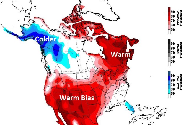
The long range 12Z Euro suggest once we get beyond the first week or so of December, changes are in the works. The Gulf of Alaska low begins to retrograde W and a +PNA begins to develop. Also that model suggests an Arctic plunge begins to enter the N/Central Plains. Nice to see some agreement now in the longer range operational guidance...for a change...
- Attachments
-
Carla/Alicia/Jerry(In The Eye)/Michelle/Charley/Ivan/Dennis/Katrina/Rita/Wilma/Humberto/Ike/Harvey
Member: National Weather Association
Facebook.com/Weather Infinity
Twitter @WeatherInfinity
Member: National Weather Association
Facebook.com/Weather Infinity
Twitter @WeatherInfinity
-
srainhoutx
- Site Admin
- Posts: 19700
- Joined: Tue Feb 02, 2010 2:32 pm
- Location: Maggie Valley, NC
- Contact:
Morning e-mail from Jeff:
Little hope for meaningful rainfall for at least the next 7 days and possibly well into mid December. Additionally, cold air will stay bottled up in Canada with this fast paced zonal flow in place across the US blocking any cold air intrusions.
Zonal flow aloft (west to east) is pushing the cool high pressure from the Monday night frontal passage eastward this morning with weak onshore winds starting to return to the area. This will be the last cold morning for several days as a strong storm system moving into the NW US coast and then into Canada will keep an onshore flow in place from today through at least Tuesday…possibly longer. Will see morning lows warm from the 40’s today to the 50’s on Friday and then the 60’s after Friday into next week. Afternoon highs will be downright balmy for early December in the upper 70’s and low 80’s under increasingly humid conditions. Temperatures will be running a solid 10 degrees above climate averages.
In the rainfall department…it would appear that drought has taken a foothold on the region as the weather system on Monday night was unable to produce good rainfall and the area will sink deeper into already moderate to severe drought. While a couple of weak disturbances will pass over the region in the WSW flow tonight and Friday, the quality and depth of moisture return off the western Gulf is poor and expect that only a few isolated showers may develop in the Matagorda Bay to College Station area. Not expecting much more than maybe a .10 of an inch in this region. With onshore winds in place for several days I cannot rule out a rogue showers or two at really any time over the weekend into early next week…but rainfall if any will be on the light side and highly isolated…consider yourself lucky if you see some! Skies will become partly to mostly cloudy today and this will linger through much of the coming period with some potential for dense morning fog on both Friday and Saturday mornings.
Next cold front was slated to move into the area and off the coast around Tuesday of next week, but nearly every forecast model has really backed off on the push of this front southward as the main energy heads more NE into Canada and the push of cold air and surface high pressure down the plains much weaker. Frontal boundary may limp into the region and stall which might support cooling of temperature to about 5 degrees above normal, but no big cool down looks in store for the region through next week. Rain chances have all but dried up with this front with energy displaced well to our N and NE over the Great Lakes and pesky SSW to SW mid level flow bringing the dreaded capping inversion over the area helping to limit convective growth. I suppose we could see a few showers along the stalling boundary…but widespread rainfall is not expected.
The US and TX is stuck in this pattern which is bringing warmth and dryness to much of the nation driven strongly by the large Pacific storm system off the NW US coast in the Gulf of Alaska. Extended range models keep toying with the idea of some much colder air making a southward plunge toward the middle of the month, but they continue to push the onset of the upper air buckling and changing of this zonal flow aloft back in time which brings significant doubt when and if it will happen.
Climate:
Most locations will end the month of November with less than an inch of rainfall. This follows an extremely dry October where rainfall was only about 25-35% of normal across the area. KBDI values continue to increase with the threat for wildfires rising. Brazoria County has issued a burn ban and I suspect a few more counties will be heading in that direction in December as vegetation health declines under dry conditions.
Carla/Alicia/Jerry(In The Eye)/Michelle/Charley/Ivan/Dennis/Katrina/Rita/Wilma/Humberto/Ike/Harvey
Member: National Weather Association
Facebook.com/Weather Infinity
Twitter @WeatherInfinity
Member: National Weather Association
Facebook.com/Weather Infinity
Twitter @WeatherInfinity
-
wxman57
- Global Moderator
- Posts: 2621
- Joined: Thu Feb 04, 2010 5:34 am
- Location: Southwest Houston (Westbury)
- Contact:
You left off my favorite part of Jeff's morning email, the subject - "Dry and Warm". Maybe like the Arizona desert?
-
srainhoutx
- Site Admin
- Posts: 19700
- Joined: Tue Feb 02, 2010 2:32 pm
- Location: Maggie Valley, NC
- Contact:
While we may be warm and dry here in Texas/Louisiana, the main weather headline for the US will likely be out West in Northern California/Pacific NW where a multi event flooding rainfall/higher elevation snow pattern is underway and will continue into next week...
PRELIMINARY EXTENDED FORECAST DISCUSSION
NWS HYDROMETEOROLOGICAL PREDICTION CENTER COLLEGE PARK MD
324 AM EST THU NOV 29 2012
VALID 12Z MON DEC 03 2012 - 12Z THU DEC 06 2012
...ANOTHER ONSLAUGHT OF HEAVY PRECIPITATION FOR THE
NORTHWEST/NORTHERN CALIFORNIA EARLY TO MID NEXT WEEK...
GENERAL FLOW PATTERN/MODEL PREFERENCES
======================================
TWIN POLAR VORTICES NEAR SOUTHERN ALASKA AND OVER NUNAVUT/THE
CANADIAN ARCHIPELAGO THROUGH THE MEDIUM RANGE PERIOD SHOULD KEEP
THE FLOW PATTERN PROGRESSIVE ACROSS THE MID-LATITUDES OF THE
EASTERN PACIFIC AND NORTH AMERICA THIS PERIOD. THE BIG QUESTION
IS HOW PROGRESSIVE. WITH THE INITIAL LONGWAVE TROUGH MOVING
THROUGH NORTH AMERICA, THE 00Z GFS IS THE QUICKEST TO THE MOVE IT
EASTWARD WHILE THE 00Z UKMET IS THE SLOWEST/MOST SOUTHWEST. ALL
IN ALL, THE 00Z ECMWF KEPT THE BEST CONTINUITY FROM DAY-TO-DAY,
AND IS CLOSEST TO THE ENSEMBLE MEAN SOLUTIONS LATE IN THE PERIOD.
A COMPROMISE OF THE 00Z GFS/00Z ECMWF WAS REASONABLE THROUGH
TUESDAY BEFORE SWITCHING TO A 00Z ECMWF/00Z GEFS MEAN SOLUTION FOR
THIS SYSTEM FOR MID NEXT WEEK.
TROUGHING MOVING FROM THE EASTERN PACIFIC INTO THE NORTHWEST ALSO
SHOWS SOME PROGRESSION ISSUES. WHILE OVERALL THE 00Z GFS IS
SLOWER AND A BETTER FIT TO THE ENSEMBLE MEANS, THE NORTHERN PIECE
OF ENERGY AT THE APEX OF THIS TROUGH IS MORE PROGRESSIVE IN THE
GFS SCENARIO, WHICH ULTIMATELY LEADS TO A MORE PROGRESSIVE SURFACE
SYSTEM AND FRONT OVER THE NORTHERN HIGH PLAINS. THE 00Z GEFS MEAN
SHOWS A BIT MORE DEFINITION THAN THE ECMWF ENSEMBLE MEAN SOLUTION
DOES, SO THOUGHT IT MORE USABLE. A COMPROMISE OF THE 00Z
ECMWF/00Z GEFS MEAN APPEARS BEST HERE, THOUGH DID INCORPORATE SOME
IDEAS THAT A SLOWED DOWN 00Z GFS WOULD HAVE PROVIDED.
WEATHER IMPACTS
===============
SUNDAY IS THE LAST DAY OF THE FIRST ROUND OF VERY HEAVY
PRECIPITATION AND WIND FOR NORTHERN CALIFORNIA/OREGON BEFORE THE
LONGWAVE TROUGH MOVES EASTWARD, SPREADING LESSER PRECIPITATION
THROUGH THE INTERMOUNTAIN WEST/CENTRAL ROCKIES MONDAY. AS THE
SYSTEM EMERGES INTO THE PLAINS, A MOISTURE TAP SETS UP FROM THE
GULF OF MEXICO, SPREADING MODERATE TO HEAVY RAINS FROM EASTERN
TEXAS INTO THE MID-MISSISSIPPI VALLEY AND MID-SOUTH MONDAY NIGHT
INTO TUESDAY, CENTRAL APPALACHIANS TUESDAY, WITH LIGHTER
PRECIPITATION FOR THE GREAT LAKES AND NORTHEAST TUESDAY INTO
WEDNESDAY.
MEANWHILE, HEAVY PRECIPITATION FOCUSES UPON THE PACIFIC NORTHWEST
INTO NORTHERN CALIFORNIA ONCE AGAIN FROM LATE MONDAY INTO THURSDAY
BEFORE PROGRESSING ACROSS THE NORTHERN CONTINENTAL DIVIDE AND
CENTRAL ROCKIES WEDNESDAY INTO NEXT THURSDAY. WITH THIS ROUND OF
PRECIPITATION, 2-4 INCHES AREAL AVERAGE LIQUID EQUIVALENT
PRECIPITATION (WITH LOCAL AMOUNTS NEXT 6 INCHES) FALLING IN THE
FORM OF VALLEY RAINS AND MOUNTAIN SNOWS IS EXPECTED, WHICH COULD
EXACERBATE ISSUES CAUSED BY THE MUCH HEAVIER PRECIPITATION
EXPECTED BETWEEN NOW AND SUNDAY. STAY TUNED.
ROTH
Here are some pictures I took back in January 2008 of the Northern California Region. One of the biggest concerns is the flooding aspect from this event. Certainly the region has been in a multi year drought and the lakes and reservoirs will benefit. The other issue may well be the flood potential for the Sacramento River Basin/Sacramento Valley near Redding.
Carla/Alicia/Jerry(In The Eye)/Michelle/Charley/Ivan/Dennis/Katrina/Rita/Wilma/Humberto/Ike/Harvey
Member: National Weather Association
Facebook.com/Weather Infinity
Twitter @WeatherInfinity
Member: National Weather Association
Facebook.com/Weather Infinity
Twitter @WeatherInfinity