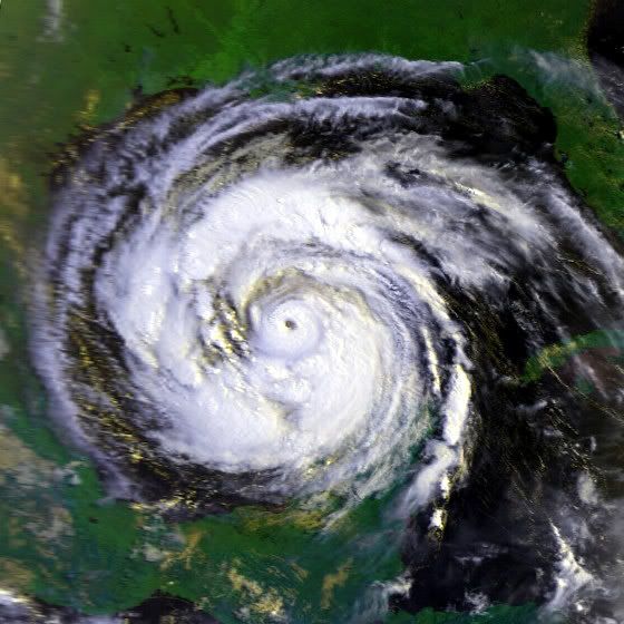
Strongest Hurricane To Hit Houston/Galveston

Tropical Weather Discussions and Analysis
Post Reply
User avatar
Ptarmigan
Statistical Specialist
Posts: 4034
Joined: Wed Feb 03, 2010 7:20 pm
Contact:

Since hurricane season is looming, one has to wonder what it the strongest winds to be ever felt. As for major hurricane force sustained winds in Houston, that is probably unlikely to happen as WXMan57 points out because we are further inland.

http://z.khou.com/forums/viewtopic.php? ... icane#1061

As for major hurricane force wind gusts, that has happened before. Here are the strongest hurricanes to hit the Houston area. Keep in mind that Houston was largely not developed and populated at the time. This is based on Best Track from 1870-2010.

Great Galveston Hurricane-125 Knots
July 1909 Hurricane-105 Knots
1915 Galveston Hurricane-115 Knots
Freeport Hurricane of 1932-125 Knots
October 1949 Hurricane-115 Knots
September 1941 Hurricane-100 Knots (It was re-analyzed recently)
Alicia-100 Knots

The Great Galveston Hurricane made landfall as a Category 4 with 145 mph winds. I recall reading that Houston mostly recorded tropical storm to hurricane force winds, no reports of major hurricane force winds. Houston was not heavily populated at the time, which means less weather stations and co-ops.
http://web.archive.org/web/200707112023 ... /1900s.htm
For some reason, the Houston NWS deleted the SE Texas Hurricane climatology section. :?

Houston recorded 80 mph winds from the 1915 Hurricane. Once again, major hurricane force winds likely happened and Houston was not heavily populated at the time, which means less weather stations and co-ops.
http://web.archive.org/web/200503102249 ... /1910s.htm

Houston recorded 60 mph from the 1932 Freeport Hurricane. It was a small hurricane that did 30-40 mile swath of damage.
http://web.archive.org/web/200503102302 ... /1930s.htm

Houston recorded 77 mph winds in the September 1941 hurricane. Once again, major hurricane force winds likely happened, as it was a large hurricane.
http://news.google.com/newspapers?id=bK ... 09,5353456
http://www.wunderground.com/hurricane/at1941.asp
http://web.archive.org/web/200503102306 ... /1940s.htm

Houston recorded 90 mph winds in the October 1949 hurricane. However, major hurricane force winds were very likely, but went unrecorded due to not many weather stations at the time because Houston was not developed as it is today.
http://drgeorgepc.com/Hurricane1949Galveston.html
http://web.archive.org/web/200503102306 ... /1940s.htm

Houston mostly received strong tropical storm to hurricane force winds from Alicia.
http://www.aoml.noaa.gov/hrd/Storm_page ... nd_mph.pdf
http://web.archive.org/web/200610092057 ... /1980s.htm

Major hurricanes that have made landfall mainly occurred when Houston was less populated than it was today. It is very likely major hurricane force winds were felt in Houston in those hurricanes, but there were not as many weather stations to record them unlike today.
Last edited by Ptarmigan on Wed Apr 07, 2010 6:30 pm, edited 1 time in total.
User avatar
Ptarmigan
Statistical Specialist
Posts: 4034
Joined: Wed Feb 03, 2010 7:20 pm
Contact:

Ed Mahmoud wrote:How are those ordered? By likely strongest winds in HOU? The wind speeds next to them, that was maximum storm windspeed at landfall?


I thought Galveston was a low end Cat 4.


But I could be wrong...
Chronological order. I agree that the Galveston 1900 Hurricane was a Category 4 and did some edits.
User avatar
Paul
Posts: 535
Joined: Wed Feb 03, 2010 11:46 pm
Location: Pearland
Contact:

Nice work PT....Its been a long time since Houston has seen a major hurricane with inland hurricane winds...I good upper Cat 3 would do the trick and anything above that...Would have to be a Surfside hit moving NW through Brazoria into Harris. That would put us in the right front quad.....never been in a right quad...I was in the west eyewall of Ike for about 6hours. Nothing to sneeze about.
TexasMetBlake
Pro Met
Pro Met
Posts: 839
Joined: Wed Feb 03, 2010 7:03 pm
Location: Spring/Woodlands
Contact:

I completely disagree. Houston is WELL within reach of major hurricane force winds given the trajectory and forward motion is favorable. There are numerous hurricanes that have hit in years past that has pushed powerful winds well inland. Case in point...Hurricane Hugo in 1989. Wind damage was reported in Charlotte, NC--200 miles inland. Hurricane Rita also brought hurricane force winds WELL inland. There is an unofficial wind reading on Lake LIvingston of 137 mph. Grant it, it may have been at an elevated spot on the dam with little obstruction, but still. Hurricane Katrina brought damage all the way to Tennessee. I know what the Spring/Woodlands area looked like after Ike and it was a total MESS and Ike was a Cat. 1 when it passed overhead. Downtown Houston is only 47 miles inland by way of mile markers and even closer to the water as the crow flies.

There is a formula that takes all this into account but can not find it. But for every so many miles inland, a hurricane loses a certain percentage of velocity thanks to friction. However if you or anybody else is trying to tell me that a hurricane with 165 mph sustained winds and a 900 ish pressure hits the west end of Galveston pushing WNW at 12mph won't cause winds of over 115 mph IN HOUSTON is living in a state of delusion. Hurricane Ike isn't the third most costly hurricane in history just because it wiped out the boliver peninsula and caused damage in Galveston. The fourth largest city in the country sits just beyond the horizon. That's why Ike ranks so high. Of course, that's just my opinion.
User avatar
Ptarmigan
Statistical Specialist
Posts: 4034
Joined: Wed Feb 03, 2010 7:20 pm
Contact:

Candy Cane wrote:I completely disagree. Houston is WELL within reach of major hurricane force winds given the trajectory and forward motion is favorable. There are numerous hurricanes that have hit in years past that has pushed powerful winds well inland. Case in point...Hurricane Hugo in 1989. Wind damage was reported in Charlotte, NC--200 miles inland. Hurricane Rita also brought hurricane force winds WELL inland. There is an unofficial wind reading on Lake LIvingston of 137 mph. Grant it, it may have been at an elevated spot on the dam with little obstruction, but still. Hurricane Katrina brought damage all the way to Tennessee. I know what the Spring/Woodlands area looked like after Ike and it was a total MESS and Ike was a Cat. 1 when it passed overhead. Downtown Houston is only 47 miles inland by way of mile markers and even closer to the water as the crow flies.

There is a formula that takes all this into account but can not find it. But for every so many miles inland, a hurricane loses a certain percentage of velocity thanks to friction. However if you or anybody else is trying to tell me that a hurricane with 165 mph sustained winds and a 900 ish pressure hits the west end of Galveston pushing WNW at 12mph won't cause winds of over 115 mph IN HOUSTON is living in a state of delusion. Hurricane Ike isn't the third most costly hurricane in history just because it wiped out the boliver peninsula and caused damage in Galveston. The fourth largest city in the country sits just beyond the horizon. That's why Ike ranks so high. Of course, that's just my opinion.
No argument from me. Quite frankly, if we get a major hurricane over us, people are going to be in a major shock of their life. :o I think all those records I showed from past major hurricanes were before the wind gauge went out. I am wind gauge back than were weaker than today's wind gauge. Also Houston is more populated and if a major hurricane was to hit, especially a large one, it will be catastrophic. I remember Hurricane Gilbert being really large over the Gulf of Mexico and was forecasted to hit Southeast Texas.
TexasMetBlake
Pro Met
Pro Met
Posts: 839
Joined: Wed Feb 03, 2010 7:03 pm
Location: Spring/Woodlands
Contact:

Ptarmigan wrote:
Candy Cane wrote:I completely disagree. Houston is WELL within reach of major hurricane force winds given the trajectory and forward motion is favorable. There are numerous hurricanes that have hit in years past that has pushed powerful winds well inland. Case in point...Hurricane Hugo in 1989. Wind damage was reported in Charlotte, NC--200 miles inland. Hurricane Rita also brought hurricane force winds WELL inland. There is an unofficial wind reading on Lake LIvingston of 137 mph. Grant it, it may have been at an elevated spot on the dam with little obstruction, but still. Hurricane Katrina brought damage all the way to Tennessee. I know what the Spring/Woodlands area looked like after Ike and it was a total MESS and Ike was a Cat. 1 when it passed overhead. Downtown Houston is only 47 miles inland by way of mile markers and even closer to the water as the crow flies.

There is a formula that takes all this into account but can not find it. But for every so many miles inland, a hurricane loses a certain percentage of velocity thanks to friction. However if you or anybody else is trying to tell me that a hurricane with 165 mph sustained winds and a 900 ish pressure hits the west end of Galveston pushing WNW at 12mph won't cause winds of over 115 mph IN HOUSTON is living in a state of delusion. Hurricane Ike isn't the third most costly hurricane in history just because it wiped out the boliver peninsula and caused damage in Galveston. The fourth largest city in the country sits just beyond the horizon. That's why Ike ranks so high. Of course, that's just my opinion.
No argument from me. Quite frankly, if we get a major hurricane over us, people are going to be in a major shock of their life. :o I think all those records I showed from past major hurricanes were before the wind gauge went out. I am wind gauge back than were weaker than today's wind gauge. Also Houston is more populated and if a major hurricane was to hit, especially a large one, it will be catastrophic. I remember Hurricane Gilbert being really large over the Gulf of Mexico and was forecasted to hit Southeast Texas.
It's funny to go back and look at the "cone of uncertainty" for Hurricane Gilbert. It went from western Louisiana all the way to Tampico. LOL! My how the times have changed.
User avatar
Ptarmigan
Statistical Specialist
Posts: 4034
Joined: Wed Feb 03, 2010 7:20 pm
Contact:

Candy Cane wrote: It's funny to go back and look at the "cone of uncertainty" for Hurricane Gilbert. It went from western Louisiana all the way to Tampico. LOL! My how the times have changed.
I remember Hurricane Gilbert causing a huge scare. It was the biggest scare prior to Rita in 2005. Gilbert was the most intense and one of the largest hurricanes. Think about it if Gilbert actually hit our area. It would be very catastrophic. It would probably be one of the most costliest hurricane ever. :o
TexasMetBlake
Pro Met
Pro Met
Posts: 839
Joined: Wed Feb 03, 2010 7:03 pm
Location: Spring/Woodlands
Contact:

Ptarmigan wrote:
Candy Cane wrote: It's funny to go back and look at the "cone of uncertainty" for Hurricane Gilbert. It went from western Louisiana all the way to Tampico. LOL! My how the times have changed.
I remember Hurricane Gilbert causing a huge scare. It was the biggest scare prior to Rita in 2005. Gilbert was the most intense and one of the largest hurricanes. Think about it if Gilbert actually hit our area. It would be very catastrophic. It would probably be one of the most costliest hurricane ever. :o
Without a doubt! The damage would total WAY over a hundred billion and the death toll could potentially be huge!
User avatar
Paul
Posts: 535
Joined: Wed Feb 03, 2010 11:46 pm
Location: Pearland
Contact:

that ridge never broke down as Gilbert got into the GOM after crossing the Yucatan. Alot of models were showing this at the time. It held strong and sent him into MX. I remember my Mom showing me a airline weather model that was scary even when I was a kid....She work for Continental at the time...
User avatar
srainhoutx
Site Admin
Site Admin
Posts: 19622
Joined: Tue Feb 02, 2010 2:32 pm
Location: Maggie Valley, NC
Contact:

Another concern at the time was this monster in 1980 since we are reminiscing. Raised a lot of eyebrows after the experience of TD Claudette a year earlier.

Image
Carla/Alicia/Jerry(In The Eye)/Michelle/Charley/Ivan/Dennis/Katrina/Rita/Wilma/Humberto/Ike/Harvey

Member: National Weather Association
Facebook.com/Weather Infinity
Twitter @WeatherInfinity
TexasMetBlake
Pro Met
Pro Met
Posts: 839
Joined: Wed Feb 03, 2010 7:03 pm
Location: Spring/Woodlands
Contact:

Outside of the dry air, man, when I think of what a hurricane should look like, I think of Allen. To me, it is the text book, quintessential example. Wilma at its peak also comes to mind.
TexasMetBlake
Pro Met
Pro Met
Posts: 839
Joined: Wed Feb 03, 2010 7:03 pm
Location: Spring/Woodlands
Contact:

Here's John Hope on Gilbert. He shows the track at the end.

http://www.youtube.com/watch?v=GY-boNkNC2g
User avatar
Ptarmigan
Statistical Specialist
Posts: 4034
Joined: Wed Feb 03, 2010 7:20 pm
Contact:

Hurricane Allen. Had Hurricane Allen hit as a Category 5 as it almost did and a populated area, it would be catastrophic. Allen was also a large hurricane.
Post Reply
  • Information
  • Who is online

    Users browsing this forum: No registered users and 7 guests