
August 2017: Looking Back at Harvey 5 Year Later
-
mcheer23
- Global Moderator

- Posts: 606
- Joined: Fri Jan 11, 2013 11:15 am
- Location: Missouri City/ Sugar Land
- Contact:
UKMET Cat 3 Galveston
-
Scott747
- Posts: 1648
- Joined: Tue Feb 23, 2010 9:56 am
- Location: Freeport/Surfside Beach
- Contact:
No. Nothing scheduled till early Wednesday. Data should be in the 12z runs if i have my timing down.TexasBreeze wrote: Were there any upper air flight missions run today for the models?
-
Rip76

- Posts: 2133
- Joined: Mon Feb 15, 2010 12:38 am
- Location: The Woodlands
- Contact:
You go take a swim at the hotel pool, and come back to this?
-
mcheer23
- Global Moderator
- Posts: 606
- Joined: Fri Jan 11, 2013 11:15 am
- Location: Missouri City/ Sugar Land
- Contact:
CMC basically copies the 12z EURO and completely floods SE TX
-
DoctorMu

- Posts: 8048
- Joined: Sun Jun 28, 2015 11:58 am
- Location: College Station
- Contact:
GFS looking brutal per rainfall and location in the 0Z run. 


-
Rip76
- Posts: 2133
- Joined: Mon Feb 15, 2010 12:38 am
- Location: The Woodlands
- Contact:
I'm still thinking this is a Tex/Mex.
It just seems so tough to be pulled that far north.
It just seems so tough to be pulled that far north.
-
stormlover
- Posts: 439
- Joined: Wed Dec 04, 2013 10:21 am
- Location: Lumberton TX
- Contact:
Go look at matt lanza twitter, it has happen plenty of times
-
DoctorMu
- Posts: 8048
- Joined: Sun Jun 28, 2015 11:58 am
- Location: College Station
- Contact:
Canadian 0z has Harvey wafting up the Texas coast and swamping the entire HGX and Corpus areas.

-
Scott747
- Posts: 1648
- Joined: Tue Feb 23, 2010 9:56 am
- Location: Freeport/Surfside Beach
- Contact:
I think at the minimum the nhc should have something of a hook putting parts of the lower Texas coast in the 5 day graph. Also with the continuing trend its about time to not only inject interests along the northern Mexican coast to begin monitoring the remnants of Harvey, but for at least the lower and middle Texas coastal residents to do the same.
*edit*
For the 1am update
*edit*
For the 1am update
-
Scott747
- Posts: 1648
- Joined: Tue Feb 23, 2010 9:56 am
- Location: Freeport/Surfside Beach
- Contact:
Well the wording didn't change. But that was one hell of a shift with the graphical outlook...
-
DoctorMu
- Posts: 8048
- Joined: Sun Jun 28, 2015 11:58 am
- Location: College Station
- Contact:
0Z Euro run coming in. At 72 hrs similar to last run so far.
-
DoctorMu
- Posts: 8048
- Joined: Sun Jun 28, 2015 11:58 am
- Location: College Station
- Contact:
[120] and [144] around Corpus
GEFS ensemble models:
https://twitter.com/RaleighWx/status/899811128737492992
About 10 in of rain in HGX
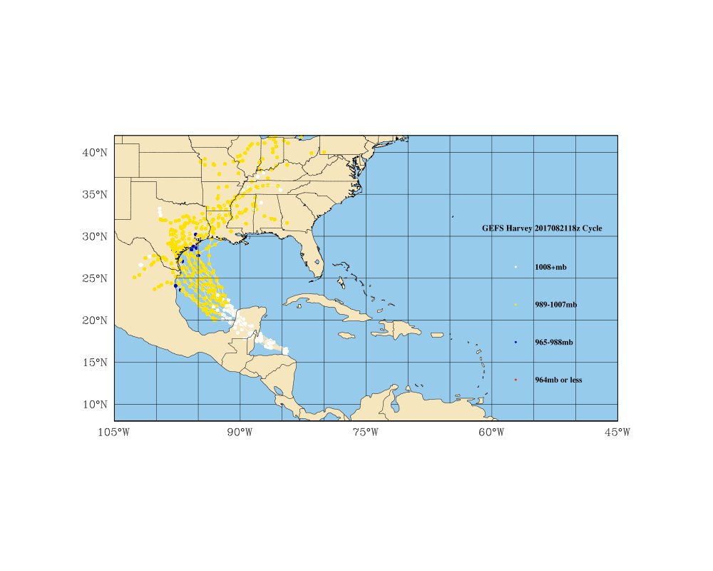
GEFS ensemble models:
https://twitter.com/RaleighWx/status/899811128737492992
About 10 in of rain in HGX
-
DoctorMu
- Posts: 8048
- Joined: Sun Jun 28, 2015 11:58 am
- Location: College Station
- Contact:
There's a lot of time, and change is the most likely outcome, but...
[168] hr hugging the coast around Matagorda Bay.

and into Louisiana at [192] Quite similar to the 12z Monday run.
NAVGEM with another similar run at 0z.

[168] hr hugging the coast around Matagorda Bay.
and into Louisiana at [192] Quite similar to the 12z Monday run.
NAVGEM with another similar run at 0z.
-
srainhoutx

- Site Admin

- Posts: 19700
- Joined: Tue Feb 02, 2010 2:32 pm
- Location: Maggie Valley, NC
- Contact:
I see the overnight guidance (both deterministic and ensembles) continue to shift toward a more Texas event. Time to start paying very close attention and begin those early preparations such as checking your food and water supplies and replenish if needed.
My concern regarding a possible inland flood event lasting several days has increased overnight regardless of where Harvey makes its landfall whether it is a moderate to strong Tropical Storm or weak Hurricane. The very slow movement after nearing the Texas Coast is rather worrisome.
Today is the day to let family, friends, neighbors and colleagues that may not be so weather savvy know of the potential ahead for Thursday throughout the coming weekend and possibly into next Monday.
- Attachments
-
-
-
Carla/Alicia/Jerry(In The Eye)/Michelle/Charley/Ivan/Dennis/Katrina/Rita/Wilma/Humberto/Ike/Harvey
Member: National Weather Association
Facebook.com/Weather Infinity
Twitter @WeatherInfinity
Member: National Weather Association
Facebook.com/Weather Infinity
Twitter @WeatherInfinity
-
Scott747
- Posts: 1648
- Joined: Tue Feb 23, 2010 9:56 am
- Location: Freeport/Surfside Beach
- Contact:
6z gfs is a major coming in around Sargent and rapidly deepening up to landfall. Then slowly moves n and then ne.
-
Andrew
- Site Admin
- Posts: 3508
- Joined: Wed Feb 03, 2010 9:46 pm
- Location: North-West Houston
- Contact:
About as worse case as you could get. Will be interesting to see if the trend continues eastward as models detect higher influence from the weakness.Scott747 wrote:6z gfs is a major coming in around Sargent and rapidly deepening up to landfall. Then slowly moves n and then ne.
For Your Infinite Source For All Things Weather Visit Our Facebook
-
srainhoutx
- Site Admin
- Posts: 19700
- Joined: Tue Feb 02, 2010 2:32 pm
- Location: Maggie Valley, NC
- Contact:
Ugh...Scott747 wrote:6z gfs is a major coming in around Sargent and rapidly deepening up to landfall. Then slowly moves n and then ne.
- Attachments
-
-
Carla/Alicia/Jerry(In The Eye)/Michelle/Charley/Ivan/Dennis/Katrina/Rita/Wilma/Humberto/Ike/Harvey
Member: National Weather Association
Facebook.com/Weather Infinity
Twitter @WeatherInfinity
Member: National Weather Association
Facebook.com/Weather Infinity
Twitter @WeatherInfinity
-
Scott747
- Posts: 1648
- Joined: Tue Feb 23, 2010 9:56 am
- Location: Freeport/Surfside Beach
- Contact:
Yeah its about 15 to 30 miles away from being what ive always considered the worst case scenario with the suggested track. A major heading up 288 and slowing down after landfall.Andrew wrote:About as worse case as you could get. Will be interesting to see if the trend continues eastward as models detect higher influence from the weakness.Scott747 wrote:6z gfs is a major coming in around Sargent and rapidly deepening up to landfall. Then slowly moves n and then ne.
And before we send anyone into a panic.... These are still just potential scenarios and for now is nothing more than that. I can promise you as the day progesses and if the modeling continues to suggest anything remotely like they are now... There is plenty of time to take precautions.
-
Karen
- Posts: 85
- Joined: Thu Feb 04, 2010 6:58 am
- Location: League City, Texas
- Contact:
When is this expected to come ashore I dont understand all of the numbers you guys post. Thank you for all of the fantastic information you post.
-
TexasBreeze
- Posts: 1026
- Joined: Sun Sep 26, 2010 4:46 pm
- Location: NW Houston, TX
- Contact:
Friday thru Saturday on that model. Maybe a shot at LA if it continues east shifts each run?? That is assuming a strong hurricane. A weaker system would probably go more west.