
April 2025
-
jasons2k

- Posts: 6196
- Joined: Thu Feb 04, 2010 12:54 pm
- Location: Imperial Oaks
- Contact:
Got a nice .78” here.
-
Cpv17
- Posts: 7094
- Joined: Fri Aug 31, 2018 1:58 pm
- Location: El Campo/Wharton
- Contact:
Nothing here. Surprise surprise.Stratton20 wrote: ↑Thu Apr 24, 2025 9:04 pm And just as i figured, that line fell apart right on my door step
-
Pas_Bon
- Posts: 954
- Joined: Tue Sep 11, 2018 7:58 am
- Location: League City, TX
- Contact:
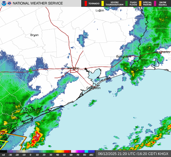
Serious question…..why do most of these lines of storms seem to break apart south of the metro area lately? This has been a pretty common theme for the past few years that I can recall. What is causing it? We got some rain in League City, but it always seems to break apart as it rolls down.
Of course, it always also seems to build back near Beaumont and into Louisiana.
Of course, it always also seems to build back near Beaumont and into Louisiana.
-
swell
- Posts: 4
- Joined: Mon Sep 16, 2019 6:54 pm
- Contact:
In general, atmosphere tends to be more stable there this time of year due to cooler water temps. Yesterday's system was also losing daytime heating as tracked south in the evening and was also displaced a good distance from its parent vort lobe and upper level diffluence. Combination of the above tends to allow for lowering instability with both time and distance... thereby weakening.Pas_Bon wrote: ↑Fri Apr 25, 2025 1:15 am Serious question…..why do most of these lines of storms seem to break apart south of the metro area lately? This has been a pretty common theme for the past few years that I can recall. What is causing it? We got some rain in League City, but it always seems to break apart as it rolls down.
Of course, it always also seems to build back near Beaumont and into Louisiana.
-
tireman4

- Global Moderator

- Posts: 7140
- Joined: Wed Feb 03, 2010 9:24 pm
- Location: Humble, Texas
- Contact:
485
FXUS64 KHGX 251155
AFDHGX
Area Forecast Discussion
National Weather Service Houston/Galveston TX
655 AM CDT Fri Apr 25 2025
...New AVIATION...
.SYNOPSIS...
Issued at 304 AM CDT Fri Apr 25 2025
We come to the end of an active weather week, and today gives us
one more chance for some isolated to scattered showers and storms,
before fair weather and a little warmer temperatures prevail for
the weekend.
- The best potential for showers and storms looks to focus
northwest of Houston in the afternoon. However, some potential
for light showers begins near the coast this morning before
shifting more inland for the afternoon.
- This weekend, as rain chances exit, warmer weather steps in.
Look for highs to drift into the upper half of the 80s for all
but the Gulf coast, and some hot spots will look to crack 90
degrees.
- The next stretch with rain and storms will come in the middle to
latter part of next week as another front bogs down in the
region. Stay with us into the new week for the latest forecast
information.
&&
.SHORT TERM...
(Today through Saturday Night)
Issued at 304 AM CDT Fri Apr 25 2025
So, we`re all agreed that when remembering my discussion last
night, we will definitely recall me talking about storms to our
north deforming the flow sufficiently to induce a right turn and a
push through Southeast Texas. And we`re definitely *not* going to
recall me saying that it was plausible but unlikely and I expected
it to truck more eastward by us, right? Awesome, great. Forecast
went awesome!
After the afternoon/evening`s MCS rolling through, things have
begun to settle into a more typical nocturnal pattern for this
time of year, with some low stratus beginning to crop up over
SETX, along with some patches of fog here and there, surely
boosted by moisture from the earlier rain. Those clouds should
lift and scatter through the morning, perhaps with some quick,
light coastal showers. And in the afternoon, we`ll have a warm
afternoon (lower half of the 80s highs) with isolated to scattered
showers and storms. However, ridging will be building its way into
the area, especially later this afternoon into the evening, which
will likely tamp down just how much convective activity we can
look forward to.
Tonight, no surprise as low level onshore flow keeps right on
trucking, is a return of some stratus overnight into tomorrow
morning, with some patches of fog here and there. And would you be
shocked to learn that those clouds will lift and scatter through
the morning into mid-day? But in the afternoon, we finally should
break the daily pattern of rain and storms. Ridging by tomorrow
afternoon will have built in enough that, while another shortwave
trough does move through the region, it will be shoved up to
around/north of the Red River. Instead, we get to hang out under a
partly cloudy sky, which should allow temps to drift more into the
upper half of the 80s than the lower half.
&&
.LONG TERM...
(Sunday through Thursday)
Issued at 304 AM CDT Fri Apr 25 2025
Sunday continues to feature benign weather with a broad upper level
ridge spanning across the Plains with an upper level closed low over
the Desert Southwest. This ridging aloft should keep rain chances
sparse through Monday. Warm and humid conditions can be expected
throughout this timeframe with highs in the 80s, reaching the 90
degree mark in some spots.
The aforementioned closed low will transition to an elongated upper
level/shortwave trough as pushes eastward towards the Plains early
next week. Rain chances rise through Tuesday as this systems draws
closer to SE Texas, supplying additional shortave energy/impulses.
Model guidance still suggests that this system will drape a slow-
moving cold front/quasi-stationary boundary over portions of
Oklahoma/the ArkLaTex area by Wednesday, serving as a focus for
shower/storms and possibly some higher rainfall totals as the trough
continues eastward. Current guidance suggests that this boundary
should push southward through the later half of next week, most
likely around Friday. Still, it`s presence in the vicinity should
bring some rounds of showers/storms over the second half of the work
week.
&&
.AVIATION...
(12Z TAF Issuance)
Issued at 655 AM CDT Fri Apr 25 2025
A mix of conditions across the area, mostly LIFR with low stratus
and localized patches of dense fog. However, some sites are at
IFR, MVFR, and even a few VFR (like GLS!). Through the morning,
fog dissipates and clouds scatter with area returning to VFR along
with southeast winds of 5 to 10 kts. Light coastal showers are
possible, but not enough potential for a mention in the TAFs,
which should shift inland into the afternoon, along with even a
small amount of lightning. But because today`s activity will be
more isolated than previous days, only have enough confidence for
a PROB30 -SHRA from SGR northward. Stronger wording can be added
if impact for a particular terminal becomes apparent.
&&
.MARINE...
Issued at 304 AM CDT Fri Apr 25 2025
Onshore winds of 10 to 15 knots as seas of 3 to 5 feet can be
expected up through the beginning of next week. Isolated showers and
thunderstorms will be possible daily, moreso through Friday with
sparse to near-zero rain chances over the weekend. Persistent
onshore winds will also bring a higher risk of rip currents along
Gulf-facing beaches.
&&
.PRELIMINARY POINT TEMPS/POPS...
College Station (CLL) 85 67 86 68 / 30 20 0 0
Houston (IAH) 85 69 85 70 / 20 0 0 0
Galveston (GLS) 81 73 80 73 / 10 0 0 0
&&
.HGX WATCHES/WARNINGS/ADVISORIES...
TX...None.
GM...None.
&&
$$
SHORT TERM...Luchs
LONG TERM....03
AVIATION...Luchs
MARINE...03
-
DoctorMu

- Posts: 8048
- Joined: Sun Jun 28, 2015 11:58 am
- Location: College Station
- Contact:
Yesterday - the sun set. The diurnal effect was strong. There was some dry air in the mid levels. The air was likely more stable with less shear.Pas_Bon wrote: ↑Fri Apr 25, 2025 1:15 am Serious question…..why do most of these lines of storms seem to break apart south of the metro area lately? This has been a pretty common theme for the past few years that I can recall. What is causing it? We got some rain in League City, but it always seems to break apart as it rolls down.
Of course, it always also seems to build back near Beaumont and into Louisiana.
-
Stratton20
- Posts: 5827
- Joined: Tue Feb 09, 2021 11:35 pm
- Location: College Station, Texas
- Contact:
Watching the first week of april closely for a potential flooding setup , starting to get hints in the models of a cut off low setting up shop somewhere in the desert sw
-
Cpv17
- Posts: 7094
- Joined: Fri Aug 31, 2018 1:58 pm
- Location: El Campo/Wharton
- Contact:
GFS is crickets around here man.Stratton20 wrote: ↑Fri Apr 25, 2025 1:02 pm Watching the first week of april closely for a potential flooding setup , starting to get hints in the models of a cut off low setting up shop somewhere in the desert sw
-
DoctorMu
- Posts: 8048
- Joined: Sun Jun 28, 2015 11:58 am
- Location: College Station
- Contact:
0.95 inches IMFY. Survive and advance to May 1!
Next week also looks like that line east of San Angelo to east of Wichita Falls will see the most severe weather + rain. A diminishing gradient on the Euro SE of Waco and especially south of Hwy 1*5.
As next week moves on toward the weekend. I'd guess that seabreeze showers will provide a decent chance of rain for Houston.
Speaking of the Seabreeze, there are some SB showers real time, migrating Northerly toward Navasota. Hopefully, it lasts until over B/CS.
-
Stratton20
- Posts: 5827
- Joined: Tue Feb 09, 2021 11:35 pm
- Location: College Station, Texas
- Contact:
Moderate ( level 2/3) risk of heavy rainfall in the 3-9th of may time frame, CPC is buying into the Euros idea of a slow moving cut off low setting up shop in west texas
-
DoctorMu
- Posts: 8048
- Joined: Sun Jun 28, 2015 11:58 am
- Location: College Station
- Contact:
Gotta be honest. Looks like the usual ULL ejection NE into OK, KS, and MO. We could see some rain, but expect a gradient from Waco to the coast.
- Attachments
-
- ecmwf_apcpn_us_57.png
- (150.03 KiB) Downloaded 6464 times
-
- ecmwf_z500a_us_48.png
- (123.03 KiB) Downloaded 6464 times
-
- ecmwf_mslp_pcpn_frzn_us_47.png
- (180.2 KiB) Downloaded 6464 times
-
Cpv17
- Posts: 7094
- Joined: Fri Aug 31, 2018 1:58 pm
- Location: El Campo/Wharton
- Contact:
It honestly doesn’t look like too much around here except for the very far western areas.Stratton20 wrote: ↑Fri Apr 25, 2025 2:21 pm Moderate ( level 2/3) risk of heavy rainfall in the 3-9th of may time frame, CPC is buying into the Euros idea of a slow moving cut off low setting up shop in west texas
-
Stratton20
- Posts: 5827
- Joined: Tue Feb 09, 2021 11:35 pm
- Location: College Station, Texas
- Contact:
Cpv17 it will probably change being 12 days out or so, think they are putting that risk out early because of pattern recognition, one thing to watch for is a -NAO setting up, that could slow down any storm system from ejecting out of the state too quickly if that comes to fruition
-
DoctorMu
- Posts: 8048
- Joined: Sun Jun 28, 2015 11:58 am
- Location: College Station
- Contact:
Don will report on the action.Stratton20 wrote: ↑Fri Apr 25, 2025 2:21 pm Moderate ( level 2/3) risk of heavy rainfall in the 3-9th of may time frame, CPC is buying into the Euros idea of a slow moving cut off low setting up shop in west texas
-
DoctorMu
- Posts: 8048
- Joined: Sun Jun 28, 2015 11:58 am
- Location: College Station
- Contact:
That dang cell is sitting about 3 miles north of mi casa. It's trying to back build, but is being stymied. lolDoctorMu wrote: ↑Fri Apr 25, 2025 2:02 pm 0.95 inches IMFY. Survive and advance to May 1!
Next week also looks like that line east of San Angelo to east of Wichita Falls will see the most severe weather + rain. A diminishing gradient on the Euro SE of Waco and especially south of Hwy 1*5.
As next week moves on toward the weekend. I'd guess that seabreeze showers will provide a decent chance of rain for Houston.
Speaking of the Seabreeze, there are some SB showers real time, migrating Northerly toward Navasota. Hopefully, it lasts until over B/CS.
-
tireman4
- Global Moderator
- Posts: 7140
- Joined: Wed Feb 03, 2010 9:24 pm
- Location: Humble, Texas
- Contact:
Today
- Attachments
-
- small1-1.png (338.87 KiB) Viewed 17864 times
-
- small2-1.png (306.29 KiB) Viewed 17865 times
-
don

- Posts: 3148
- Joined: Wed Feb 03, 2010 3:33 pm
- Location: Wichita Falls
- Contact:
We're getting a training MCS this morning...
- Attachments
-
- download (3).png (672.29 KiB) Viewed 17862 times
-
Stratton20
- Posts: 5827
- Joined: Tue Feb 09, 2021 11:35 pm
- Location: College Station, Texas
- Contact:
Don could probably explain this better than me, but models are starting to show a very interesting yet slightly concerning setup as we begin May. Cut off low gets trapped somewhere in the deep south , potentially setting up shop over texas, the low is a slow mover because of - NAO blocking stopping it from moving, this idea is starting to consistently show up in models now, as Jasons2k pointed out, some of our biggest flood events in may have happened from cut off lows, this pattern definitely warrants attention for sure
- Attachments
-
- IMG_3666.png
- (688.23 KiB) Downloaded 6419 times
-
- IMG_3665.png
- (728.22 KiB) Downloaded 6419 times
-
- IMG_3664.png
- (754.61 KiB) Downloaded 6419 times
-
tireman4
- Global Moderator
- Posts: 7140
- Joined: Wed Feb 03, 2010 9:24 pm
- Location: Humble, Texas
- Contact:
Week Ahead
- Attachments
-
- small1-2.png (242.97 KiB) Viewed 17830 times
-
DoctorMu
- Posts: 8048
- Joined: Sun Jun 28, 2015 11:58 am
- Location: College Station
- Contact:
The low continues to eject NE for late in the week. So, there's a chance, but I'd expect a gradient. Streamer showers and the seabreeze will be our best chance of rain in the latter half of the week. The projected path is easily seen here on the Euro:
- Attachments
-
- ecmwf_apcpn_us_45.png
- (145.37 KiB) Downloaded 6384 times