July 2025

General Weather Discussions and Analysis
Post Reply
User avatar
Rip76
Posts: 2030
Joined: Mon Feb 15, 2010 12:38 am
Location: The Woodlands
Contact:

TxLady wrote: Tue Jul 08, 2025 3:08 pm These daily Thunderstorms remind me so much of the early 1970's, growing up in South Houston. Our local swimming pool opened every day at 1:00 pm. It was staffed by our High School Football coach and lifeguards were the Football players. Every dang day, there would come a storm at around 2:00-3:00 pm. Of course, if there's even a hint of lightning or a dark suggestive cloud anywhere near the neighborhood...the pool opening would be delayed or cancelled. My sister and I were in Junior High/Early High School. Any day without swimming pool = no interaction with cute Football players! :)

Same thing with the summers in Texas City in the early 80’s. Almost a daily occurrence at the city swimming pool. 3pm like clockwork, dark clouds would roll in, it would get windy and then it would rain for about 30 min.
Then, sunny again.
User avatar
DoctorMu
Posts: 7219
Joined: Sun Jun 28, 2015 11:58 am
Location: College Station
Contact:

Rip76 wrote: Wed Jul 09, 2025 5:19 pm
TxLady wrote: Tue Jul 08, 2025 3:08 pm These daily Thunderstorms remind me so much of the early 1970's, growing up in South Houston. Our local swimming pool opened every day at 1:00 pm. It was staffed by our High School Football coach and lifeguards were the Football players. Every dang day, there would come a storm at around 2:00-3:00 pm. Of course, if there's even a hint of lightning or a dark suggestive cloud anywhere near the neighborhood...the pool opening would be delayed or cancelled. My sister and I were in Junior High/Early High School. Any day without swimming pool = no interaction with cute Football players! :)

Same thing with the summers in Texas City in the early 80’s. Almost a daily occurrence at the city swimming pool. 3pm like clockwork, dark clouds would roll in, it would get windy and then it would rain for about 30 min.
Then, sunny again.
The pools in NC would just reopen again after the near daily storm blew through.
User avatar
Ptarmigan
Statistical Specialist
Posts: 4321
Joined: Wed Feb 03, 2010 7:20 pm
Contact:

DoctorMu wrote: Wed Jul 09, 2025 12:16 pm
Ptarmigan wrote: Tue Jul 08, 2025 9:09 pm
DoctorMu wrote: Tue Jul 08, 2025 1:35 pm Never, never underestimate warm core storms, especially at night. That's why old salt Mets are an incredibly invaluable resource. They've seen these systems, whether Atlantic or EPAC or Gulf, thwart the models and young buck Mets.

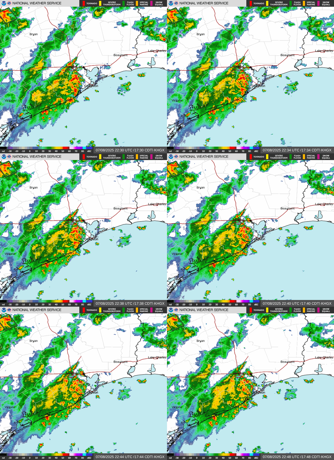
OK, we have the Louisiana wave in SETX and drying radar in the Hill Country at last.

I'm glad to see the NWS forecast leaning heavily with the Euro. College Station has a reasonable shot of rain every day heading into mid July - a rare commodity. And I'm here for that.

Image
Exactly. Core rains are notoriously difficult to forecast. Core rains are not just a Texas problem. I have seen with Hurricane Camille in Virginia and Super Typhoon Nina in China.
Yes - Helene and a litany of Atlantic Coast hurricanes when moving north into the Appalachian Mountains.
Them too. I read that Camille may have dumped up to 46 inches of rain or higher. Super Typhoon Nina caused the Banqiao Dam to fail and claimed over 100,000 lives. Nina dumped up over 64 inches of rain on Banqiao Dam.

Erosional and Depositional Aspects of Hurricane Camille in Virginia, 1969
https://pubs.usgs.gov/pp/0804/report.pdf

Typhoon Nina and the August 1975 Flood over Central China
https://journals.ametsoc.org/view/journ ... 0152_1.xml
User avatar
tireman4
Global Moderator
Global Moderator
Posts: 6292
Joined: Wed Feb 03, 2010 9:24 pm
Location: Humble, Texas
Contact:

598
FXUS64 KHGX 101138
AFDHGX

Area Forecast Discussion
National Weather Service Houston/Galveston TX
638 AM CDT Thu Jul 10 2025

...New AVIATION...

.KEY MESSAGES...
Issued at 117 PM CDT Wed Jul 9 2025

- Scattered to widespread showers and thunderstorms can be
expected each day through the upcoming weekend.

- Isolated strong thunderstorms will result in gusty winds and
periods of heavy rainfall and could lead to ponding of water
along roadways, as well as minor flooding over poor drainage and
low lying areas.

- Daily high temperatures will continue to be at or just below
seasonal temperatures through the weekend. Regardless, it is
summer in Southeast TX and technically still hot. Make sure to
take breaks if spending time or working outside and stay
hydrated.

&&

.DISCUSSION...
Issued at 1056 PM CDT Wed Jul 9 2025

No significant changes were made to the forecast for this
issuance.

We will likely continue to see daily chances for showers and
thunderstorms during the next several days. This is mainly in
response to Southeast TX being wedged between a high pressure
systems situated over SW CONUS and another high pressure system
situated over the eastern Gulf, allowing for weaknesses to pass
overhead from time to time. The weather pattern will generally be
a "rinse and repeat" with passing showers possible over the waters
and coastal locations during the early to mid morning hours,
followed by stronger and more extensive development of showers and
thunderstorms further inland during the mid morning to late
afternoon hours as diurnal heating and instability increases. The
PWs on Thursday are expected to stay in the 1.8" to 2.0" range,
which could result in pocket of moderate to heavy rain with
rainfall rates of 2-3" per hour in some locations. This could lead
to ponding of water along roadways, as well as minor flooding in
areas of poor drainage. The heavy downpours may occur during the
afternoon commute, thus, make sure to check the radar and traffic
conditions before you depart to your destination. Remember, never
cross flooded roads.

Moisture is expected decrease on Friday, as drier air moves into
the region and could lead to lower PoPs. Regardless, we can at
least expect isolated showers and thunderstorms during the daytime
hours. For the upcoming weekend, our rain chances look to
increase again as an upper level trough moves across the Southern
Plains and PWs rise back to 1.8" to 2.0" which may result in
scattered to widespread showers and thunderstorms. A similar
weather pattern can be expected on Sunday. Please be mindful of
how the weekend weather can affect your travel. Also, if you or
your family are planning to spend time or work outdoors or visit
our local beaches, keep in mind that lightning can strike many
miles away from the storm. When thunder roars, head indoors.

One good thing about the rain and cloud coverage, is that it`s
keeping our high temperatures at or just below seasonal norms.
Thus, we are expected our highs to remain mostly in the lower 90s
through the weekend. From Monday into Tuesday, however, we may see
a gradual decrease in shower and thunderstorm activity as another
pocket of drier air passes through. This could lead to higher
temperatures, which some spots possibly seeing highs in the upper
90s. As for our low temperatures, expect them to be between the
mid to upper 70s inland and the upper 70s to lower 80s for the
coastal locations.

Cotto

&&

.AVIATION...
(12Z TAF Issuance)
Issued at 632 AM CDT Thu Jul 10 2025

Widely scattered shra may impact our northern terminals (CLL,
UTS) this morning. Spotty shra offshore expected to move towards
the coast as the morning progresses. By late morning and early
afternoon, isolated to scattered shra/tsra expected to develop
in the vicinity of the sea breeze. Not much model agreement
regarding coverage with some suggesting scattered activity while
others calling for more isolated shra/tsra. Prevailing SW wind
develops this morning, then veers to the S and potentially SE this
afternoon. May have MVFR cigs tomorrow morning in the Brazos
Valley. For now, CLL TAF shows lower end VFR for tomorrow morning.


&&

.MARINE...
Issued at 1056 PM CDT Wed Jul 9 2025

Light to occasionally moderate onshore winds and 2 to 4 foot seas
will prevail for the next several days. Periods of showers and
thunderstorms are anticipated each day. We can expect to see
showers and thunderstorms developing along the Gulf waters and
coastal locations during the morning to early afternoon hours,
followed by less activity during the mid afternoon to evening
hours as storms move further inland. However, a strong storm or
two cannot be discarded during that timeframe, in particular over
the bays. Stronger storms could lead to strong gusty winds and
outflow boundaries and could elevate seas at times.

Along the Gulf facing beaches, persistent onshore flow will
result in a moderate risk of rip currents. High risk of rip
currents could occur at times. Please follow the beach flag
conditions, and always swim near a lifeguard.

Cotto

&&

.PRELIMINARY POINT TEMPS/POPS...
College Station (CLL) 92 75 92 75 / 20 10 10 0
Houston (IAH) 93 77 92 78 / 40 10 30 10
Galveston (GLS) 91 83 91 84 / 40 10 30 20

&&

.HGX WATCHES/WARNINGS/ADVISORIES...
TX...None.
GM...None.
&&

$$

DISCUSSION...Cotto
AVIATION...Self
MARINE...Cotto
User avatar
DoctorMu
Posts: 7219
Joined: Sun Jun 28, 2015 11:58 am
Location: College Station
Contact:

Camille took a right turn in Kentucky and savaged the Appalachians and Blue Ridge mountains in Virginia. Cat 5 storm energy/warm core + mountains and rocky soil = major flooding.
User avatar
tireman4
Global Moderator
Global Moderator
Posts: 6292
Joined: Wed Feb 03, 2010 9:24 pm
Location: Humble, Texas
Contact:

694
FXUS64 KHGX 101814
AFDHGX

Area Forecast Discussion
National Weather Service Houston/Galveston TX
114 PM CDT Thu Jul 10 2025

...New KEY MESSAGES, DISCUSSION, MARINE...

.KEY MESSAGES...
Issued at 111 PM CDT Thu Jul 10 2025

-Isolated to scattered showers and storms are expected this
afternoon, mainly east of I-45. The best rain and storm chances
return this weekend.

- A daily risk of showers and storms continues in the next 7 days,
though coverage is expected to be less as we head into the upcoming
week.

- Daily high temperatures will continue to be at or just below
seasonal temperatures through the weekend, before gradually
warming up next week. Remember to keep practicing heat safety!
Make sure to take breaks if spending time or working outside and
stay hydrated.


&&

.DISCUSSION...
Issued at 111 PM CDT Thu Jul 10 2025

A notable shift in the weather pattern this afternoon compared to
yesterday. A drier airmass has filtered in from the northwest,
leading to a significant drop in rain and storm chances. This drier
influence is evident across areas west of I-45, where skies have
become less active and mostly sunny. Taking a look at the latest
Blended TPW satellite, a corridor of higher PWs is still persisting
in areas roughly east of I-45, with values at or above 2.0 inches.
This pocket of higher moisture combined with the peak of daytime
heating will provide enough fuel to support isolated to scattered
convection through sunset. Will continue with 15 to 30% of PoPs
mainly east of I-45, including the greater Houston area through
early this evening.

Southeast Texas remains sandwiched between two areas of high
pressure aloft. Adding to this set up, a surface high pressure
remains anchored across the eastern/central Gulf, maintaining a
steady supply of warm and humid southerly flow across the region.
This pattern will maintain largely similar weather conditions each
day, with a daily risk of isolated to scattered showers and storms
and warm conditions. Friday is expected to be similar to today
(Thursday) with the best rain/storm chances developing across the
coastal counties and over the Gulf waters. Remember, continuous
southerly and humid flow can enhance moisture convergence and
trigger showers and storms, mainly during the afternoon heating.

A slightly more active pattern is expected this weekend, with an
uptick in moisture, and rain and storm chances. Increasing moisture
advection from the Gulf and the development of some trough weakness
aloft will be enough to spark showers and thunderstorms throughout
the day.

Beyond the weekend, the long-range forecast indicates a shift
towards hotter conditions and slightly lower precipitation
chances. The ridge to our east is projected to strengthen and
shift westward, directly influencing Southeast TX. So, ridging
aloft usually means hot conditions. In fact, temperatures are
expected to be near the 90th percentile of climatology based on
NAEFS and GEFS (mostly after Tuesday). Overall, expect highs
mainly in the mid to upper 90s, with heat indices close to
advisory levels. In terms of precipitation, while more stable air
will move in, persistent southerly surface flow will keep low-
level moisture and convergence across parts of the region,
particularly in the afternoons. 15 to 30% of PoPs are progged each
day.

JM

&&

.AVIATION...
(12Z TAF Issuance)
Issued at 632 AM CDT Thu Jul 10 2025

Widely scattered shra may impact our northern terminals (CLL,
UTS) this morning. Spotty shra offshore expected to move towards
the coast as the morning progresses. By late morning and early
afternoon, isolated to scattered shra/tsra expected to develop
in the vicinity of the sea breeze. Not much model agreement
regarding coverage with some suggesting scattered activity while
others calling for more isolated shra/tsra. Prevailing SW wind
develops this morning, then veers to the S and potentially SE this
afternoon. May have MVFR cigs tomorrow morning in the Brazos
Valley. For now, CLL TAF shows lower end VFR for tomorrow morning.

&&

.MARINE...
Issued at 111 PM CDT Thu Jul 10 2025

Surface high pressure remains strong across the central Gulf. This
pattern will continue to bring south to southwest light to moderate
winds and seas around 2 to 4 ft across the Upper TX coast over the
next several days. A daily risk of isolated to scattered showers and
thunderstorms is also expected. Most of this activity will occur in
the mornings offshore and along the coast and bays (further inland)
after midday. Gusty winds can be expected around any storms. This
weather pattern is expected to continue over the next 7 days.

JM

&&

.PRELIMINARY POINT TEMPS/POPS...
College Station (CLL) 74 92 75 90 / 10 10 0 60
Houston (IAH) 76 92 77 91 / 20 30 10 70
Galveston (GLS) 83 90 83 90 / 20 20 30 70

&&

.HGX WATCHES/WARNINGS/ADVISORIES...
TX...None.
GM...None.
&&

$$

DISCUSSION...JM
AVIATION...Self
MARINE...JM
Post Reply
  • Information
  • Who is online

    Users browsing this forum: Ahrefs [Bot], Bing [Bot] and 5 guests