
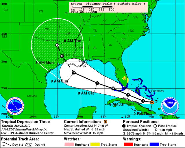
email from Jeff Lindner thursday afternoon:
Tropical depression forms in the SE Bahamas.
A threat to TX/LA coasts late this weekend.
A Tropical Storm Warning is issued for the coast of FL from Golden Beach to Key West on the E coast and from Bonita Beach southward on the west coast.
Discussion:
The tropical wave being followed (97L) the past several days has developed a well defined surface circulation and deep convection and it upgraded to a tropical depression over the SE Bahama Islands. Visible satellite images show a well defined center exposed on the W and SW side of the deeper convection in a classic upper level shear pattern. The upper level low NW of the system is hampering development at the moment and this system should move WNW in tandem with the TD.
Track:
Global forecast models are in fairly tight agreement on a general WNW track into the eastern Gulf of Mexico and then into the central and NW Gulf of Mexico over the next 72-96 hours. General track reasoning supports this track as the system is embedded south of a intensifying ridge of high pressure over the SE US which will guide the system mainly WNW to landfall. On this track the storm will approach the SE TX/SW LA coast late Sunday night/early Monday morning. On this track adverse conditions will impact the entire oil spill area.
Intensity:
Forecast models are not aggressive with the development of this system as the large upper level low to its west will continue to impart shear of the tropical cyclone. NHC brings the storm to 50mph over the central Gulf of Mexico and all forecast models keep it at or below 60mph until landfall. Should upper level shear over the system weaken, then additional intensification would be possible, but this is not currently forecast.
Impacts:
Will take a detailed look at impacts Friday morning. Right now at least an increase in rain chances and coastal winds is likely…but worst of the weather may end up NE/E of our region with any kind of sheared tropical threat moving just ENE of our region. Current landfall location is reasonable within 60 miles either side of the TX/LA border with most of the weather aimed to the east of the center.
Tropical Depression Bonnie forms 5:15 PM 7/22/2010
-
ticka1
- Posts: 1265
- Joined: Wed Feb 03, 2010 3:02 pm
- Location: Baytown/Mont Belvieu
- Contact:
-
singlemom

- Posts: 119
- Joined: Thu Feb 04, 2010 10:11 pm
- Location: Spring, Texas
- Contact:
And the 2:00 models flip flops it back to Louisiana......I wish it would make up it's mind....
-
ticka1
- Posts: 1265
- Joined: Wed Feb 03, 2010 3:02 pm
- Location: Baytown/Mont Belvieu
- Contact:
Its not even in the GOM - we will see this time and time again. What you want to see is trend in model runs...the same location for 3-4 runs - then the models have a better idea. If not even in the GOM.....sit back and watch.singlemom wrote:And the 2:00 models flip flops it back to Louisiana......I wish it would make up it's mind....
-
Scott747
- Posts: 1648
- Joined: Tue Feb 23, 2010 9:56 am
- Location: Freeport/Surfside Beach
- Contact:
We're going to see some adjustments with the center reforming . The current recon mission will give us a better indication of position and heading for the short-term.
-
tireman4

- Global Moderator

- Posts: 7123
- Joined: Wed Feb 03, 2010 9:24 pm
- Location: Humble, Texas
- Contact:
ticka1 wrote:Its not even in the GOM - we will see this time and time again. What you want to see is trend in model runs...the same location for 3-4 runs - then the models have a better idea. If not even in the GOM.....sit back and watch.singlemom wrote:And the 2:00 models flip flops it back to Louisiana......I wish it would make up it's mind....
Remember Ike. Ticka had that thing coming over my house and danged if it did. ( For those newbies, we had a contest as to where Ike would cross..LOL. I was not trying to throw Ticka under the bus). I remember tracks going down to Brownsville then slowly coming back the the Houston area.
-
Andrew
- Site Admin

- Posts: 3508
- Joined: Wed Feb 03, 2010 9:46 pm
- Location: North-West Houston
- Contact:
Scott747 wrote:We're going to see some adjustments with the center reforming . The current recon mission will give us a better indication of position and heading for the short-term.
Yea but long-term it won't make much of a difference because the ridge will dictate where it goes. The only way I see this relocation impacting the long term is if it make landfall in Florida and dramatically weakens it sending it even farther to the west....
For Your Infinite Source For All Things Weather Visit Our Facebook
-
MRG93415
- Posts: 123
- Joined: Fri Apr 23, 2010 3:36 pm
- Location: Cypress, TX
- Contact:
tireman4 wrote:ticka1 wrote:Its not even in the GOM - we will see this time and time again. What you want to see is trend in model runs...the same location for 3-4 runs - then the models have a better idea. If not even in the GOM.....sit back and watch.singlemom wrote:And the 2:00 models flip flops it back to Louisiana......I wish it would make up it's mind....
Remember Ike. Ticka had that thing coming over my house and danged if it did. ( For those newbies, we had a contest as to where Ike would cross..LOL. I was not trying to throw Ticka under the bus). I remember tracks going down to Brownsville then slowly coming back the the Houston area.
LOL, I remember that...Boy this board was going crazy that week....
-
Scott747
- Posts: 1648
- Joined: Tue Feb 23, 2010 9:56 am
- Location: Freeport/Surfside Beach
- Contact:
I think we might see a mild adjustment with the long term track with the upcoming package.Andrew wrote:Scott747 wrote:We're going to see some adjustments with the center reforming . The current recon mission will give us a better indication of position and heading for the short-term.
Yea but long-term it won't make much of a difference because the ridge will dictate where it goes. The only way I see this relocation impacting the long term is if it make landfall in Florida and dramatically weakens it sending it even farther to the west....
For those interested when looking at the NHC cone make sure and use the 'track on' option to give a little more detail on the idea of a exact path. As they always say though don't get to fixated on the exact center projections.
-
gocuse22

- Posts: 134
- Joined: Thu Feb 04, 2010 3:50 pm
- Contact:
I think models will keep trending north....
-
tireman4
- Global Moderator
- Posts: 7123
- Joined: Wed Feb 03, 2010 9:24 pm
- Location: Humble, Texas
- Contact:
But, I am an amateur, and this is unofficial, and nobody can sue Belo, or the EasternWx forum, or KHOU-TV 11, or Lucy Nolen, who is a babe but I can't say it or Mrs. Mahmoud might club me to death with a package of frozen chicken in my sleep. Amateur, unofficial, any rebroadcast, transmission or use without the express written consent of the National Football League and its broadcast partners is strictly prohibited.
Huh? Ed are you ok?
Huh? Ed are you ok?
-
srainhoutx

- Site Admin
- Posts: 19700
- Joined: Tue Feb 02, 2010 2:32 pm
- Location: Maggie Valley, NC
- Contact:
Checking in. Any RECON data worth noting?
Carla/Alicia/Jerry(In The Eye)/Michelle/Charley/Ivan/Dennis/Katrina/Rita/Wilma/Humberto/Ike/Harvey
Member: National Weather Association
Facebook.com/Weather Infinity
Twitter @WeatherInfinity
Member: National Weather Association
Facebook.com/Weather Infinity
Twitter @WeatherInfinity
-
Andrew
- Site Admin
- Posts: 3508
- Joined: Wed Feb 03, 2010 9:46 pm
- Location: North-West Houston
- Contact:
tireman4 wrote:But, I am an amateur, and this is unofficial, and nobody can sue Belo, or the EasternWx forum, or KHOU-TV 11, or Lucy Nolen, who is a babe but I can't say it or Mrs. Mahmoud might club me to death with a package of frozen chicken in my sleep. Amateur, unofficial, any rebroadcast, transmission or use without the express written consent of the National Football League and its broadcast partners is strictly prohibited.
Huh? Ed are you ok?
Ed has always been um.... different....
I still think your too far to the east there Ed. You underestimate the intensity of this ridge and that will determine the landfall. The relocation now shouldn't have too much impact on the final landfall.
For Your Infinite Source For All Things Weather Visit Our Facebook
-
redfish1
- Posts: 73
- Joined: Sat Jun 19, 2010 9:44 am
- Location: port arthur, tx
- Contact:
i agree i think the original track is what is going to pan outAndrew wrote:tireman4 wrote:But, I am an amateur, and this is unofficial, and nobody can sue Belo, or the EasternWx forum, or KHOU-TV 11, or Lucy Nolen, who is a babe but I can't say it or Mrs. Mahmoud might club me to death with a package of frozen chicken in my sleep. Amateur, unofficial, any rebroadcast, transmission or use without the express written consent of the National Football League and its broadcast partners is strictly prohibited.
Huh? Ed are you ok?
Ed has always been um.... different....
I still think your too far to the east there Ed. You underestimate the intensity of this ridge and that will determine the landfall. The relocation now shouldn't have too much impact on the final landfall.
-
tireman4
- Global Moderator
- Posts: 7123
- Joined: Wed Feb 03, 2010 9:24 pm
- Location: Humble, Texas
- Contact:
I know Andrew, but this was... for Ed...even odd. LOLAndrew wrote:tireman4 wrote:But, I am an amateur, and this is unofficial, and nobody can sue Belo, or the EasternWx forum, or KHOU-TV 11, or Lucy Nolen, who is a babe but I can't say it or Mrs. Mahmoud might club me to death with a package of frozen chicken in my sleep. Amateur, unofficial, any rebroadcast, transmission or use without the express written consent of the National Football League and its broadcast partners is strictly prohibited.
Huh? Ed are you ok?
Ed has always been um.... different....
I still think your too far to the east there Ed. You underestimate the intensity of this ridge and that will determine the landfall. The relocation now shouldn't have too much impact on the final landfall.
-
srainhoutx
- Site Admin
- Posts: 19700
- Joined: Tue Feb 02, 2010 2:32 pm
- Location: Maggie Valley, NC
- Contact:
Vortex Message...
Product: Air Force Vortex Message (URNT12 KNHC)
Transmitted: 22nd day of the month at 19:43Z
Aircraft: Air Force Aircraft (Last 3 digits of the tail number are 306)
Mission Purpose: Investigate second suspect area (flight in the North Atlantic basin)
Mission Number: 2
Observation Number: 14
A. Time of Center Fix: 22nd day of the month at 19:20:30Z
B. Center Fix Coordinates: 22°25'N 75°07'W (22.4167N 75.1167W)
B. Center Fix Location: 171 miles (276 km) to the NNE (16°) from Santiago de Cuba, Cuba.
C. Minimum Height at Standard Level: Not Available
D. Estimated (by SFMR or visually) Maximum Surface Wind: 29kts (~ 33.4mph)
E. Location of the Estimated Maximum Surface Wind: 22 nautical miles (25 statute miles) to the WNW (296°) of center fix
F. Maximum Flight Level Wind Inbound: From 24° at 33kts (From the NNE at ~ 38.0mph)
G. Location of Maximum Flight Level Wind Inbound: 24 nautical miles (28 statute miles) to the WNW (297°) of center fix
H. Minimum Sea Level Pressure: 1006mb (29.71 inHg) - Extrapolated
I. Maximum Flight Level Temp & Pressure Altitude Outside Eye: 24°C (75°F) at a pressure alt. of 183m (600ft)
J. Maximum Flight Level Temp & Pressure Altitude Inside Eye: 25°C (77°F) at a pressure alt. of 217m (712ft)
K. Dewpoint Temp (collected at same location as temp inside eye): 21°C (70°F)
K. Sea Surface Temp (collected at same location as temp inside eye): Not Available
L. Eye Character: Not Available
M. Eye Shape: Not Available
N. Fix Determined By: Penetration, Radar, Wind, Pressure and Temperature
N. Fix Levels (sfc and flt lvl centers are within 5nm of each other): Surface and 1,500 feet
O. Navigation Fix Accuracy: 0.03 nautical miles
O. Meteorological Accuracy: 0 nautical miles
Remarks Section:
Maximum Flight Level Wind: 33kts (~ 38.0mph) in the northwest quadrant at 19:12:20Z
Sea Level Pressure Extrapolation From: Below 1,500 feet
Carla/Alicia/Jerry(In The Eye)/Michelle/Charley/Ivan/Dennis/Katrina/Rita/Wilma/Humberto/Ike/Harvey
Member: National Weather Association
Facebook.com/Weather Infinity
Twitter @WeatherInfinity
Member: National Weather Association
Facebook.com/Weather Infinity
Twitter @WeatherInfinity
-
Andrew
- Site Admin
- Posts: 3508
- Joined: Wed Feb 03, 2010 9:46 pm
- Location: North-West Houston
- Contact:
Ed Mahmoud wrote:I'm ok. Just posting the amateur and unofficial disclaimer.
But this smells like Pass Christian as a 50 mph +/- storm, give or take, and I had a Summer job in Laurel, MS once, and have been to the beach in Biloxi.
AFM analyzed the ridge and plotted it on a map:
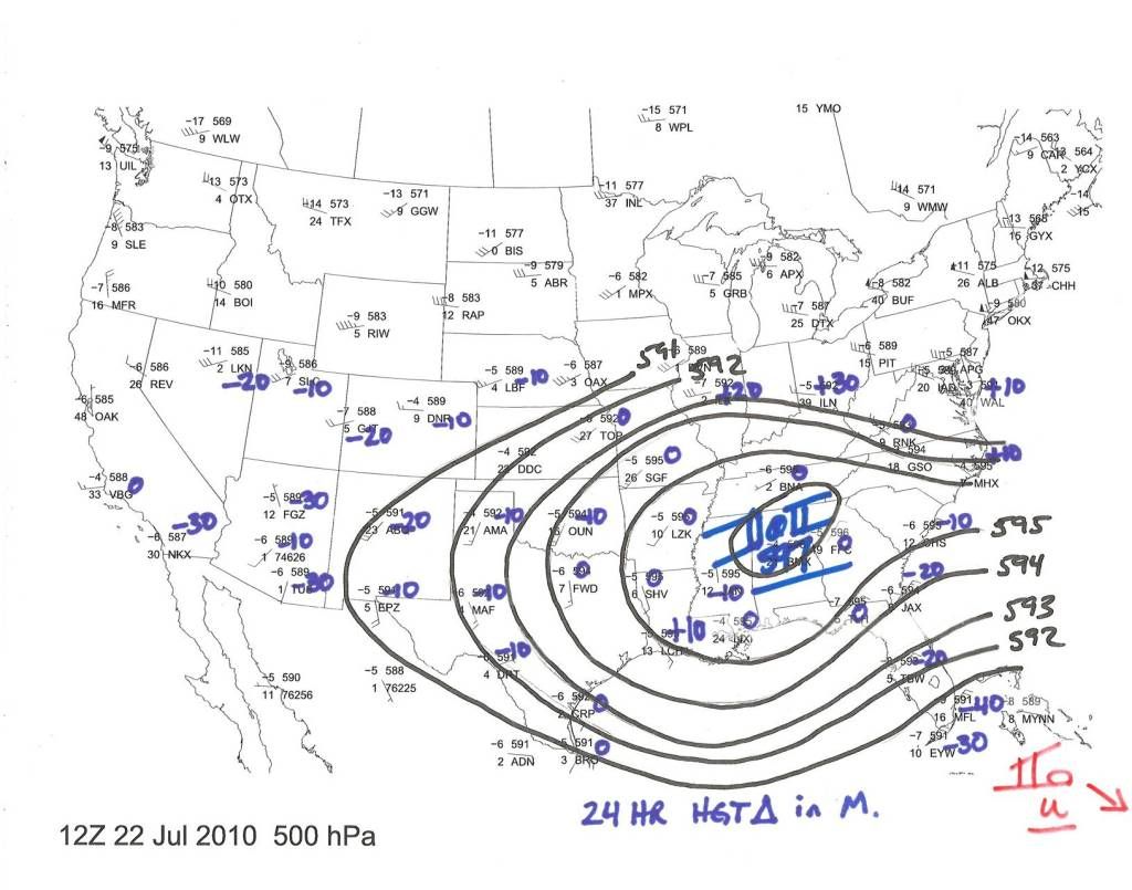
That is a pretty decent ridge and a pass that far east just doesn't look possible.
For Your Infinite Source For All Things Weather Visit Our Facebook
-
Mr. T

- Posts: 992
- Joined: Wed Feb 03, 2010 4:22 pm
- Location: Kingwood
- Contact:
Yeah, a big lol for anyone saying this is going to MS
-
jasons2k

- Posts: 6192
- Joined: Thu Feb 04, 2010 12:54 pm
- Location: Imperial Oaks
- Contact:
I don't trust the eastward shift in the models. I've been harping on the "western" solution for the last two days (in other corners) and I'm sticking to it. I think the ridge will just be too strong to allow this to go that far east.
-
sambucol

- Posts: 1244
- Joined: Wed Feb 03, 2010 5:43 pm
- Location: Mont Belvieu
- Contact:
Andrew wrote:tireman4 wrote:I agree, but I would still take a watch and see attitude. I think ( to quote Dan and Wxman57) we should just go over our hurricane preparedness lists and make sure everything is ready.
Yes I read wxman's post and was a little shocked on the bluntness of it.
What did they say? Thanks!
-
Scott747
- Posts: 1648
- Joined: Tue Feb 23, 2010 9:56 am
- Location: Freeport/Surfside Beach
- Contact:
That's quite a potent ridge. Falls inline with what Avila touched on in the disco.Mr. T wrote:Yeah, a big lol for anyone saying this is going to MS