April 2021
-
jasons2k

- Posts: 6181
- Joined: Thu Feb 04, 2010 12:54 pm
- Location: Imperial Oaks
- Contact:
Satellite shows a period of sun coming-up for the next few hours - that should heat things up for later today. I think there may be a bit more instability than expected with the sun coming out.
-
JDsGN
- Posts: 174
- Joined: Tue May 23, 2017 10:25 pm
- Location: Cypress TX
- Contact:
Our good friend Captain Cap will keep it in check have no fear! Haha hope we get some showers blossoming this afternoon
-
DoctorMu

- Posts: 7973
- Joined: Sun Jun 28, 2015 11:58 am
- Location: College Station
- Contact:
This afternoon should be interesting. However, the air outside looks a lot more stable than yesterday. No sun out. I'm calling bust...for today at least. We'll see.
-
DoctorMu
- Posts: 7973
- Joined: Sun Jun 28, 2015 11:58 am
- Location: College Station
- Contact:
Moderate CAPE, lowish shear. IF we get anything it should be a light, moderate rain today.
A lot of dry, mid level air over the Hill Country today on GOES.
https://www.star.nesdis.noaa.gov/GOES/s ... &length=24
We'll see what daytime heating brings. If anything looks favorable it's actually SOUTH of HWY Unmentionable.
A lot of dry, mid level air over the Hill Country today on GOES.
https://www.star.nesdis.noaa.gov/GOES/s ... &length=24
We'll see what daytime heating brings. If anything looks favorable it's actually SOUTH of HWY Unmentionable.
-
Cromagnum
- Posts: 3065
- Joined: Thu Feb 03, 2011 10:42 pm
- Location: Georgetown
- Contact:
Is that the 2 or 3 number unmentionable highway? LOLDoctorMu wrote: ↑Thu Apr 29, 2021 10:45 am Moderate CAPE, lowish shear. IF we get anything it should be a light, moderate rain today.
A lot of dry, mid level air over the Hill Country today on GOES.
https://www.star.nesdis.noaa.gov/GOES/s ... &length=24
We'll see what daytime heating brings. If anything looks favorable it's actually SOUTH of HWY Unmentionable.
-
don

- Posts: 3148
- Joined: Wed Feb 03, 2010 3:33 pm
- Location: Wichita Falls
- Contact:
Not expecting any significant rain today, widespread rain wont start till after midnight tonight and continuing tomorrow.GFS is still painting some very high rainfall totals.
- Attachments
-
-
DoctorMu
- Posts: 7973
- Joined: Sun Jun 28, 2015 11:58 am
- Location: College Station
- Contact:
3Cromagnum wrote: ↑Thu Apr 29, 2021 11:13 amIs that the 2 or 3 number unmentionable highway? LOLDoctorMu wrote: ↑Thu Apr 29, 2021 10:45 am Moderate CAPE, lowish shear. IF we get anything it should be a light, moderate rain today.
A lot of dry, mid level air over the Hill Country today on GOES.
https://www.star.nesdis.noaa.gov/GOES/s ... &length=24
We'll see what daytime heating brings. If anything looks favorable it's actually SOUTH of HWY Unmentionable.
-
DoctorMu
- Posts: 7973
- Joined: Sun Jun 28, 2015 11:58 am
- Location: College Station
- Contact:
-
Cpv17
- Posts: 7067
- Joined: Fri Aug 31, 2018 1:58 pm
- Location: El Campo/Wharton
- Contact:
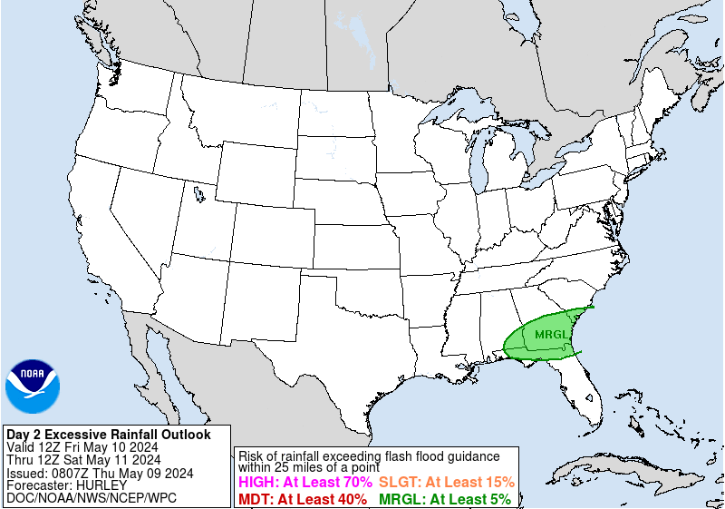
I think the WPC will upgrade the excessive rainfall forecast to either slight or moderate for a good part of southeast TX in their next update. Based on the latest run of models I’m seeing potential for 4+” for a large part of the area. Pw’s will be around 2” and at times could be exceeding that. We will be getting a large batch of unstable moist air from the western Caribbean/Gulf of Mexico.
-
DoctorMu
- Posts: 7973
- Joined: Sun Jun 28, 2015 11:58 am
- Location: College Station
- Contact:
Maybe so. It's looks pretty dry to me at the moment, with just a hair of a swirl over the western CaribbeanCpv17 wrote: ↑Thu Apr 29, 2021 1:17 pm I think the WPC will upgrade the excessive rainfall forecast to either slight or moderate for a good part of southeast TX in their next update. Based on the latest run of models I’m seeing potential for 4+” for a large part of the area. Pw’s will be around 2” and at times could be exceeding that. We will be getting a large batch of unstable moist air from the western Caribbean/Gulf of Mexico.
https://www.star.nesdis.noaa.gov/GOES/s ... &length=24
https://www.star.nesdis.noaa.gov/GOES/c ... &length=24
The low over SE New Mexico is more likely the potential wellspring of showers tonight and tomorrow.
-
DoctorMu
- Posts: 7973
- Joined: Sun Jun 28, 2015 11:58 am
- Location: College Station
- Contact:
There's a pearl thread of moisture trying to sneak into the Brazos Valley along a weak front.
https://www.star.nesdis.noaa.gov/GOES/s ... &length=24
https://www.star.nesdis.noaa.gov/GOES/s ... &length=24
-
DoctorMu
- Posts: 7973
- Joined: Sun Jun 28, 2015 11:58 am
- Location: College Station
- Contact:
Area Forecast Discussion
National Weather Service Houston/Galveston TX
1223 PM CDT Thu Apr 29 2021
.AVIATION...
A weak cold front is still well to the north of SE TX and it is
very slowly moving southward. The front will reach KCLL between
23-00z and there should be a broken line of shra/tsra. Additional
showers will develop south of the front and feed into the line.
Timing things is going to be a work in progress and leaned toward
a HRRR/TT WRF blend. Fcst soundings show some weak capping in the
850-700 mb layer both today and again on Friday yet some of the
CAMs show potential for very heavy rain.
Jet dynamics show a splitting jet structure tomorrow so have leaned toward some of the
more aggressive models. MVFR ceilings are expected this afternoon
with a mix of MVFR and IFR tonight into Friday. Could get some
patchy sea fog near KGLS as well. 43
-
Cpv17
- Posts: 7067
- Joined: Fri Aug 31, 2018 1:58 pm
- Location: El Campo/Wharton
- Contact:
Yeah that low will be tapping into a lot of moisture coming from the Gulf. The WPC mentioned that in their last excessive rainfall discussion.DoctorMu wrote: ↑Thu Apr 29, 2021 2:26 pmMaybe so. It's looks pretty dry to me at the moment, with just a hair of a swirl over the western CaribbeanCpv17 wrote: ↑Thu Apr 29, 2021 1:17 pm I think the WPC will upgrade the excessive rainfall forecast to either slight or moderate for a good part of southeast TX in their next update. Based on the latest run of models I’m seeing potential for 4+” for a large part of the area. Pw’s will be around 2” and at times could be exceeding that. We will be getting a large batch of unstable moist air from the western Caribbean/Gulf of Mexico.
https://www.star.nesdis.noaa.gov/GOES/s ... &length=24
https://www.star.nesdis.noaa.gov/GOES/c ... &length=24
The low over SE New Mexico is more likely the potential wellspring of showers tonight and tomorrow.
-
don
- Posts: 3148
- Joined: Wed Feb 03, 2010 3:33 pm
- Location: Wichita Falls
- Contact:
I agree, i would be surprised if they didn't upgrade to at least a slight risk with this afternoons update.I'm a little afraid some people could get caught off guard tomorrow if the higher qpf amounts verify. WPC showing widespread amounts of 3-4 inches now.Cpv17 wrote: ↑Thu Apr 29, 2021 1:17 pm I think the WPC will upgrade the excessive rainfall forecast to either slight or moderate for a good part of southeast TX in their next update. Based on the latest run of models I’m seeing potential for 4+” for a large part of the area. Pw’s will be around 2” and at times could be exceeding that. We will be getting a large batch of unstable moist air from the western Caribbean/Gulf of Mexico.
- Attachments
-
-
jasons2k
- Posts: 6181
- Joined: Thu Feb 04, 2010 12:54 pm
- Location: Imperial Oaks
- Contact:
I welcome the rain but after this system I will be OK with a break. Any rainy days at this point delays my pool construction!
-
jasons2k
- Posts: 6181
- Joined: Thu Feb 04, 2010 12:54 pm
- Location: Imperial Oaks
- Contact:
Couple of boundaries working to the NE....
- Attachments
-
-
DoctorMu
- Posts: 7973
- Joined: Sun Jun 28, 2015 11:58 am
- Location: College Station
- Contact:
-
DoctorMu
- Posts: 7973
- Joined: Sun Jun 28, 2015 11:58 am
- Location: College Station
- Contact:
-
Cpv17
- Posts: 7067
- Joined: Fri Aug 31, 2018 1:58 pm
- Location: El Campo/Wharton
- Contact:
The WPC upgraded our region to the slight risk in their latest update: