April 2021
-
Cpv17
- Posts: 7002
- Joined: Fri Aug 31, 2018 1:58 pm
- Location: El Campo/Wharton
- Contact:
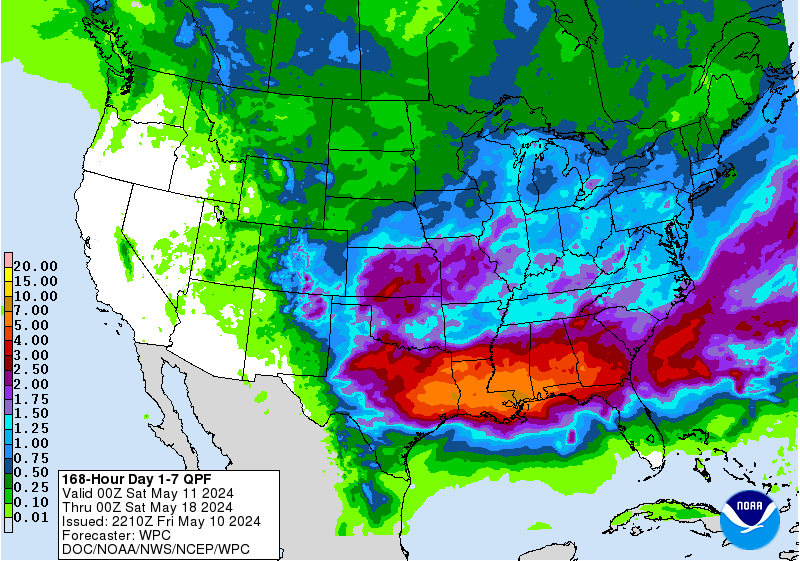
Basically all of the models at 12z show a significant system coming into the state this coming week but most of the rain stays along the the I-35 corridor and into the hill country. Shows about 1” for SE Texas.
-
unome
- Posts: 3062
- Joined: Fri Feb 12, 2010 6:11 pm
just a reminder to get off the pitty party if you didn't get enough rain & get out & stock up on suplies if you can while the tax holiday is still in effect - stay safe y'all...
https://twitter.com/ReadyHarris/status/ ... 5274022915
Emergency Preparation Supplies Sales Tax Holiday starts TODAY! Use this time to stock your emergency kits and get #Ready4Anything. See more here: http://bit.ly/2JinDiq
#ReadyRoundtheClock
https://twitter.com/ReadyHarris/status/ ... 5274022915
Emergency Preparation Supplies Sales Tax Holiday starts TODAY! Use this time to stock your emergency kits and get #Ready4Anything. See more here: http://bit.ly/2JinDiq
#ReadyRoundtheClock
- DoctorMu
- Posts: 7887
- Joined: Sun Jun 28, 2015 11:58 am
- Location: College Station
- Contact:
-
Cpv17
- Posts: 7002
- Joined: Fri Aug 31, 2018 1:58 pm
- Location: El Campo/Wharton
- Contact:
Well guys, at least we were treated to a beautiful weekend. We’ll all get some rain eventually and in my personal experience after all the crazy weather we’ve had the past few years, it’ll
probably come in the form of a flood. Seems like every dry period around here lately seems to end in a flood. My guess is something in the second half of May or early June.
probably come in the form of a flood. Seems like every dry period around here lately seems to end in a flood. My guess is something in the second half of May or early June.
-
TXWeatherMan
- Posts: 154
- Joined: Wed Oct 10, 2018 1:21 am
- Location: Lake Conroe, TX
- Contact:
Probably an early season disorganized tropical systemCpv17 wrote: ↑Sun Apr 25, 2021 7:22 pm Well guys, at least we were treated to a beautiful weekend. We’ll all get some rain eventually and in my personal experience after all the crazy weather we’ve had the past few years, it’ll
probably come in the form of a flood. Seems like every dry period around here lately seems to end in a flood. My guess is something in the second half of May or early June.
-
Cpv17
- Posts: 7002
- Joined: Fri Aug 31, 2018 1:58 pm
- Location: El Campo/Wharton
- Contact:
This looks pretty good. Guess we’ll see.


-
Cromagnum
- Posts: 3060
- Joined: Thu Feb 03, 2011 10:42 pm
- Location: Georgetown
- Contact:
I see the freeze did absolutely nothing to the bugs. Love bugs are all over the highway, and both junebugs and sod webworms are out in force already to destroy lawns.
-
Cromagnum
- Posts: 3060
- Joined: Thu Feb 03, 2011 10:42 pm
- Location: Georgetown
- Contact:
-
Cpv17
- Posts: 7002
- Joined: Fri Aug 31, 2018 1:58 pm
- Location: El Campo/Wharton
- Contact:
-
weatherguy425
- Pro Met

- Posts: 830
- Joined: Wed Feb 03, 2010 7:45 pm
- Location: Atlanta, Georgia
- Contact:
Y’all may miss the heftier rain... but check the dates on that graphic.
- djmike
- Posts: 1856
- Joined: Fri Jan 07, 2011 12:19 pm
- Location: BEAUMONT, TX
- Contact:
Also for a minute I thought man thats a complete 180 in one update. Anyway, they will probably fix it shortly.
Mike
Beaumont, TX
(IH-10 & College Street)
Beaumont, TX
(IH-10 & College Street)
- djmike
- Posts: 1856
- Joined: Fri Jan 07, 2011 12:19 pm
- Location: BEAUMONT, TX
- Contact:
Its been changed and were back to <0.25”.
Oh its gonna be a looooong summer.
Oh its gonna be a looooong summer.
Mike
Beaumont, TX
(IH-10 & College Street)
Beaumont, TX
(IH-10 & College Street)
- don
- Posts: 3147
- Joined: Wed Feb 03, 2010 3:33 pm
- Location: Wichita Falls
- Contact:
-
JDsGN
- Posts: 173
- Joined: Tue May 23, 2017 10:25 pm
- Location: Cypress TX
- Contact:
I'm going to put my money on the GFS... Prove me wrong upper level low!
-
Cpv17
- Posts: 7002
- Joined: Fri Aug 31, 2018 1:58 pm
- Location: El Campo/Wharton
- Contact:
Another Euro vs GFS battle lol go Euro!! At least this time 
-
Cromagnum
- Posts: 3060
- Joined: Thu Feb 03, 2011 10:42 pm
- Location: Georgetown
- Contact:
Yikes. If the models differ that much for rain I don't look forward to cane season models.
- don
- Posts: 3147
- Joined: Wed Feb 03, 2010 3:33 pm
- Location: Wichita Falls
- Contact:
The GFS has caved towards the EURO.All of the global models are now showing the cutoff low slowly moving across the state.Still have to iron out qpf amounts though which are very hard to pinpoint with these setups.As a lot of it is driven by mesoscale features with this kind of setup.But a good trend overnight non the less.
-
Cpv17
- Posts: 7002
- Joined: Fri Aug 31, 2018 1:58 pm
- Location: El Campo/Wharton
- Contact:
There’s still a lot of difference between the Euro and GFS in regards to qpf amounts.don wrote: ↑Wed Apr 28, 2021 7:48 am The GFS has caved towards the EURO.All of the global models are now showing the cutoff low slowly moving across the state.Still have to iron out qpf amounts though which are very hard to pinpoint with these setups.As a lot of it is driven by mesoscale features with this kind of setup.But a good trend overnight non the less.
- don
- Posts: 3147
- Joined: Wed Feb 03, 2010 3:33 pm
- Location: Wichita Falls
- Contact:
Yep, the WPC's discussion this morning has a good summary on why there's a difference in general qpf amounts over the area.The potential is there for some to get excessive rainfall with this setup, but its nearly impossible to pinpoint this far out where those locations may be due to the mesocale driven nature of the setup.Cpv17 wrote: ↑Wed Apr 28, 2021 8:24 amThere’s still a lot of difference between the Euro and GFS in regards to qpf amounts.don wrote: ↑Wed Apr 28, 2021 7:48 am The GFS has caved towards the EURO.All of the global models are now showing the cutoff low slowly moving across the state.Still have to iron out qpf amounts though which are very hard to pinpoint with these setups.As a lot of it is driven by mesoscale features with this kind of setup.But a good trend overnight non the less.
Excessive Rainfall Discussion
NWS Weather Prediction Center College Park MD
400 AM EDT Wed Apr 28 2021
Day 3
Valid 12Z Fri Apr 30 2021 - 12Z Sat May 01 2021
...THERE IS A MARGINAL RISK OF EXCESSIVE RAINFALL FROM PARTS OF
SOUTHERN/EASTERN TEXAS INTO LOUISIANA...
The upper level low over northern Mexico/southern High Plains
should remain rather stationary over the region during the day 3
period/Friday while a surface boundary is draped along the Gulf
Coast and back into far south Texas. Anomalous moisture will be
advected east of the upper low pooling along the boundary to fuel
numerous showers and thunderstorms capable of producing locally
heavy rainfall. The latest 00z guidance shows some differences in
frontal placement, especially across far eastern/coastal Texas
with some potential the heaviest QPF stays offshore completely.
Just given the overall setup favorable for locally heavy to
excessive rains, a marginal risk was drawn across southern/eastern
Texas into northern and central Louisiana but the model
uncertainty precludes the inclusion of anything more than just a
marginal at this time.
Santorelli
-
Cromagnum
- Posts: 3060
- Joined: Thu Feb 03, 2011 10:42 pm
- Location: Georgetown
- Contact:
"Points South of I-10" need to be the target this time.