February Weather Discussion. Wild Winter Storms?
-
randybpt
- Posts: 114
- Joined: Thu Feb 04, 2010 11:20 am
- Contact:
Next week we should have a couple light freezes. Looks like a dry northwesterly flow sets up next week. After that some models show a cross polar flow, still uncertain if this will come true even if it does climatology starting to be against us for true artic air this far south.
- srainhoutx
- Site Admin

- Posts: 19700
- Joined: Tue Feb 02, 2010 2:32 pm
- Location: Maggie Valley, NC
- Contact:
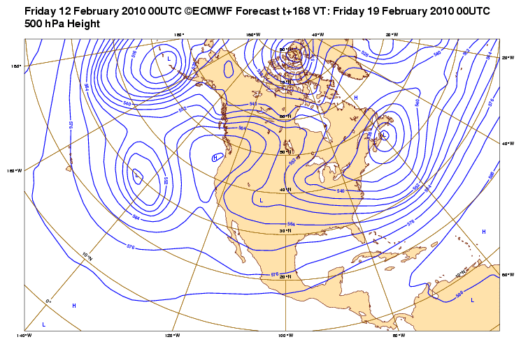
Looks like more interesting wintry weather may be ahead for TX later next week. AO, NOA, (severely negative) and a rather robust +PNA ridge is suggested by the OP as more strongly suggested via the ensembles. A very strong late winter Arctic front will pass through TX Sunday/Monday ushering some very chilly temps. There are strong suggestions that a cross Polar flow will become established later next week. The GFS has suggested a 1082mb Arctic High building which is extremely unusual. We shall see, but the ECMWF suggests a rather strong storm will dive into the region near Thursday/Friday next week with some very chilly air and more wintry precip for TX.

Carla/Alicia/Jerry(In The Eye)/Michelle/Charley/Ivan/Dennis/Katrina/Rita/Wilma/Humberto/Ike/Harvey
Member: National Weather Association
Facebook.com/Weather Infinity
Twitter @WeatherInfinity
Member: National Weather Association
Facebook.com/Weather Infinity
Twitter @WeatherInfinity
- srainhoutx
- Site Admin

- Posts: 19700
- Joined: Tue Feb 02, 2010 2:32 pm
- Location: Maggie Valley, NC
- Contact:
Randy started this Topic first, so we will let this one cover the next "threat". 
Carla/Alicia/Jerry(In The Eye)/Michelle/Charley/Ivan/Dennis/Katrina/Rita/Wilma/Humberto/Ike/Harvey
Member: National Weather Association
Facebook.com/Weather Infinity
Twitter @WeatherInfinity
Member: National Weather Association
Facebook.com/Weather Infinity
Twitter @WeatherInfinity
- srainhoutx
- Site Admin

- Posts: 19700
- Joined: Tue Feb 02, 2010 2:32 pm
- Location: Maggie Valley, NC
- Contact:
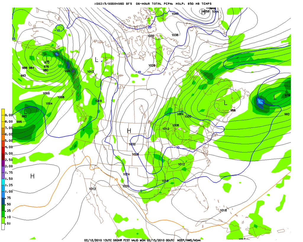
12Z GFS at 60 Hours...notice the 1058mb High in the Upper right of the chart... 

Carla/Alicia/Jerry(In The Eye)/Michelle/Charley/Ivan/Dennis/Katrina/Rita/Wilma/Humberto/Ike/Harvey
Member: National Weather Association
Facebook.com/Weather Infinity
Twitter @WeatherInfinity
Member: National Weather Association
Facebook.com/Weather Infinity
Twitter @WeatherInfinity
- snowman65
- Posts: 1415
- Joined: Thu Feb 04, 2010 6:39 am
- Location: Orange, Tx
- Contact:
[quote="srainhoutx"]12Z GFS at 60 Hours...notice the 1058mb High in the Upper right of the chart... 
What does that mean for us WAY down here?
What does that mean for us WAY down here?
Last edited by snowman65 on Fri Feb 12, 2010 10:18 am, edited 1 time in total.
- srainhoutx
- Site Admin

- Posts: 19700
- Joined: Tue Feb 02, 2010 2:32 pm
- Location: Maggie Valley, NC
- Contact:
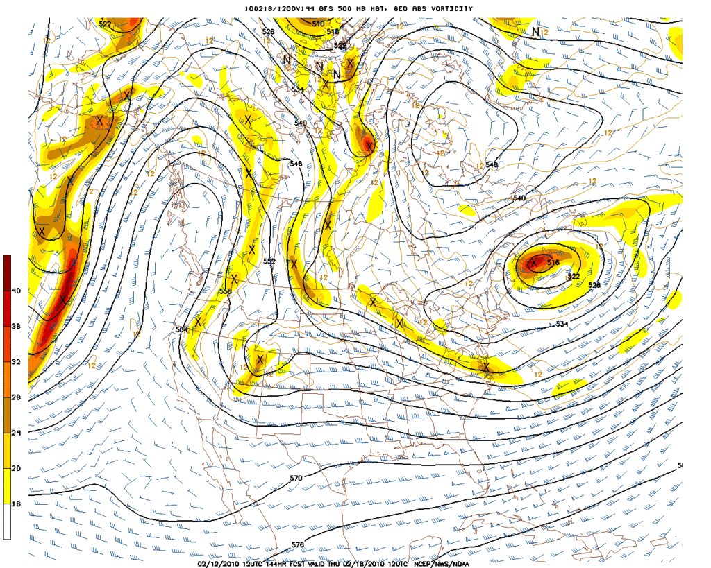
This is from a clipper type system digging very deep around the PV. We will need to see what the later runs show for a 'bigger' storm that has been progged around the 20th +/- a couple of days. Hopefully this will be the last big push of colder air this season, but I would not bet the farm on that just yet with what the ensembles are suggesting.
Carla/Alicia/Jerry(In The Eye)/Michelle/Charley/Ivan/Dennis/Katrina/Rita/Wilma/Humberto/Ike/Harvey
Member: National Weather Association
Facebook.com/Weather Infinity
Twitter @WeatherInfinity
Member: National Weather Association
Facebook.com/Weather Infinity
Twitter @WeatherInfinity
- srainhoutx
- Site Admin

- Posts: 19700
- Joined: Tue Feb 02, 2010 2:32 pm
- Location: Maggie Valley, NC
- Contact:
Carla/Alicia/Jerry(In The Eye)/Michelle/Charley/Ivan/Dennis/Katrina/Rita/Wilma/Humberto/Ike/Harvey
Member: National Weather Association
Facebook.com/Weather Infinity
Twitter @WeatherInfinity
Member: National Weather Association
Facebook.com/Weather Infinity
Twitter @WeatherInfinity
- srainhoutx
- Site Admin

- Posts: 19700
- Joined: Tue Feb 02, 2010 2:32 pm
- Location: Maggie Valley, NC
- Contact:
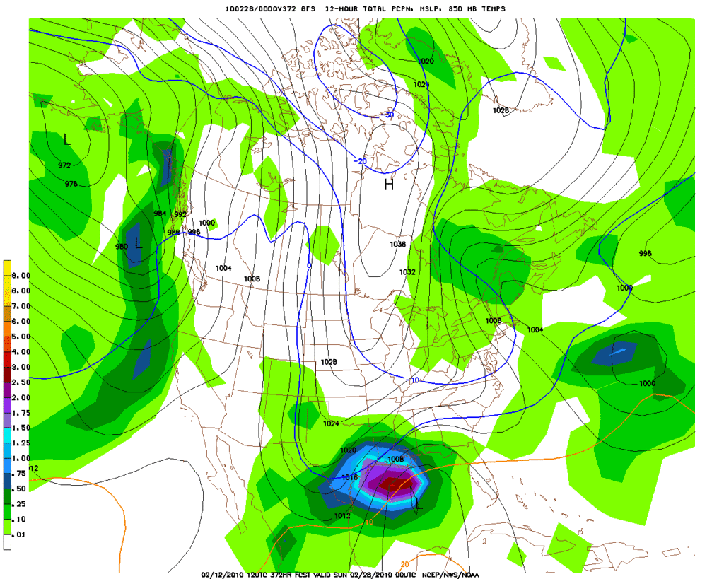
La La Land...

Carla/Alicia/Jerry(In The Eye)/Michelle/Charley/Ivan/Dennis/Katrina/Rita/Wilma/Humberto/Ike/Harvey
Member: National Weather Association
Facebook.com/Weather Infinity
Twitter @WeatherInfinity
Member: National Weather Association
Facebook.com/Weather Infinity
Twitter @WeatherInfinity
-
TexasMetBlake
- Pro Met

- Posts: 839
- Joined: Wed Feb 03, 2010 7:03 pm
- Location: Spring/Woodlands
- Contact:
Whoa...1082 mb???? That's like biblical. Are you referring to the block over Greenland and if so, what hour?srainhoutx wrote:Looks like more interesting wintry weather may be ahead for TX later next week. AO, NOA, (severely negative) and a rather robust +PNA ridge is suggested by the OP as more strongly suggested via the ensembles. A very strong late winter Arctic front will pass through TX Sunday/Monday ushering some very chilly temps. There are strong suggestions that a cross Polar flow will become established later next week. The GFS has suggested a 1082mb Arctic High building which is extremely unusual. We shall see, but the ECMWF suggests a rather strong storm will dive into the region near Thursday/Friday next week with some very chilly air and more wintry precip for TX.
- srainhoutx
- Site Admin

- Posts: 19700
- Joined: Tue Feb 02, 2010 2:32 pm
- Location: Maggie Valley, NC
- Contact:
Yesterday 18Z NAM @ hour 66...time sensitive...
http://www.nco.ncep.noaa.gov/pmb/nwprod ... p_066l.gif
http://www.nco.ncep.noaa.gov/pmb/nwprod ... p_066l.gif
Carla/Alicia/Jerry(In The Eye)/Michelle/Charley/Ivan/Dennis/Katrina/Rita/Wilma/Humberto/Ike/Harvey
Member: National Weather Association
Facebook.com/Weather Infinity
Twitter @WeatherInfinity
Member: National Weather Association
Facebook.com/Weather Infinity
Twitter @WeatherInfinity
-
TexasMetBlake
- Pro Met

- Posts: 839
- Joined: Wed Feb 03, 2010 7:03 pm
- Location: Spring/Woodlands
- Contact:
True story. Sorry, I've been working very long and late hours so I'm only catching glimpses and pieces of what's going on here. I apologize for asking dumb questions.srainhoutx wrote:Yesterday 18Z NAM @ hour 66...time sensitive...
http://www.nco.ncep.noaa.gov/pmb/nwprod ... p_066l.gif
- Ptarmigan
- Statistical Specialist

- Posts: 4502
- Joined: Wed Feb 03, 2010 7:20 pm
- Contact:
This could be much colder for us than this one.
-
ticka1
- Posts: 1265
- Joined: Wed Feb 03, 2010 3:02 pm
- Location: Baytown/Mont Belvieu
- Contact:
Any precipation with it?
- srainhoutx
- Site Admin

- Posts: 19700
- Joined: Tue Feb 02, 2010 2:32 pm
- Location: Maggie Valley, NC
- Contact:
ECMWF suggests moisture a week from today(Thursday/Friday) with yet another STJ disturbance. The interesting aspect is the Euro keeps sending shot after reinforcing shot of colder air S. A bit concerned we will not see too much air mass modification either. Snow cover is rather extensive across the CONUS now.
Carla/Alicia/Jerry(In The Eye)/Michelle/Charley/Ivan/Dennis/Katrina/Rita/Wilma/Humberto/Ike/Harvey
Member: National Weather Association
Facebook.com/Weather Infinity
Twitter @WeatherInfinity
Member: National Weather Association
Facebook.com/Weather Infinity
Twitter @WeatherInfinity
- wxman57
- Global Moderator

- Posts: 2621
- Joined: Thu Feb 04, 2010 5:34 am
- Location: Southwest Houston (Westbury)
- Contact:
Yes, interesting 12Z Euro forecasting another West Gulf Low developing next Fri/Sat with even colder air across Texas at the surface and aloft. And then colder and still stormy beyond then. So our snow chances aren't over by a long shot.
Austin will probably miss the snow, though...
Austin will probably miss the snow, though...
- Portastorm
- Posts: 800
- Joined: Wed Feb 03, 2010 3:04 pm
- Location: Southwest Austin/Oak Hill, TX
- Contact:
Listen you ... I may have to take back that International Meteorological Organization "Forecaster of the Year" nomination form I wrote up about you, Wxman57!wxman57 wrote:Yes, interesting 12Z Euro forecasting another West Gulf Low developing next Fri/Sat with even colder air across Texas at the surface and aloft. And then colder and still stormy beyond then. So our snow chances aren't over by a long shot.
Austin will probably miss the snow, though...
Meanwhile, maybe you can explain this wording from my local NWSFO in New Braunfels: A WEAK COLD FRONT WILL SAG
INTO THE REGION ON SUNDAY.
Weak front? Every other NWSFO in the state calls it a strong front with strong movement. WTH??!!
- srainhoutx
- Site Admin

- Posts: 19700
- Joined: Tue Feb 02, 2010 2:32 pm
- Location: Maggie Valley, NC
- Contact:
You left out the "good part" of the AFD Portastorm.Portastorm wrote:Listen you ... I may have to take back that International Meteorological Organization "Forecaster of the Year" nomination form I wrote up about you, Wxman57!wxman57 wrote:Yes, interesting 12Z Euro forecasting another West Gulf Low developing next Fri/Sat with even colder air across Texas at the surface and aloft. And then colder and still stormy beyond then. So our snow chances aren't over by a long shot.
Austin will probably miss the snow, though...
Meanwhile, maybe you can explain this wording from my local NWSFO in New Braunfels: A WEAK COLD FRONT WILL SAG
INTO THE REGION ON SUNDAY.
Weak front? Every other NWSFO in the state calls it a strong front with strong movement. WTH??!!
Carla/Alicia/Jerry(In The Eye)/Michelle/Charley/Ivan/Dennis/Katrina/Rita/Wilma/Humberto/Ike/Harvey
Member: National Weather Association
Facebook.com/Weather Infinity
Twitter @WeatherInfinity
Member: National Weather Association
Facebook.com/Weather Infinity
Twitter @WeatherInfinity
- Portastorm
- Posts: 800
- Joined: Wed Feb 03, 2010 3:04 pm
- Location: Southwest Austin/Oak Hill, TX
- Contact:
You mean the part about "gradual warming trend through the end of the week"?
Seriously, what are they looking at? It's just baffling to me how clueless this AFD really is. Wow.
Seriously, what are they looking at? It's just baffling to me how clueless this AFD really is. Wow.
- srainhoutx
- Site Admin

- Posts: 19700
- Joined: Tue Feb 02, 2010 2:32 pm
- Location: Maggie Valley, NC
- Contact:
THE EXTENDED 6-8 DAY FORECAST GETS UNCERTAIN ONCE AGAIN. THE 12ZPortastorm wrote:You mean the part about "gradual warming trend through the end of the week"?
Seriously, what are they looking at? It's just baffling to me how clueless this AFD really is. Wow.
GFS LOOKS VERY ODD...AS IT BREAKS APART AN UPPER TROUGH OVER THE
CONUS INTO 3-4 SEPARATE UPPER LOWS. THE ECMWF IS PREFERRED...AS
IT MAINTAINS CONTINUITY WITH PREVIOUS MODEL FORECASTS. INDICATIONS
ARE THAT LARGE SCALE RIDGING WILL DEVELOP OVER WESTERN CANADA AND
A DEEP TROUGH WILL FORM OVER THE CENTRAL CONTINENT. THIS WILL BE A
FAVORABLE PATTERN FOR CANADIAN AIR TO ENTER THE REGION BEGINNING
WITH A COLD FRONT THURSDAY. ECMWF SUGGESTS A POTENTIAL FOR WINTRY
WEATHER ONCE AGAIN THURSDAY AND FRIDAY. WILL MAINTAIN LOW POPS FOR
LIQUID PRECIP AND TEMPS IN THE 30S-40S UNTIL MORE MODEL RUNS ADD
CREDIT TO THIS SOLUTION. AND FINALLY...BY DAY 10-11...ANOTHER
ARCTIC OUTBREAK MAY OCCUR AS POLAR VORTEX/1055MB HIGH BEGINS TO
DROP SOUTH INTO CANADA. THIS WILL BE SOMETHING TO WATCH IN THE
COMING DAYS.
At least they mentioned it!
Carla/Alicia/Jerry(In The Eye)/Michelle/Charley/Ivan/Dennis/Katrina/Rita/Wilma/Humberto/Ike/Harvey
Member: National Weather Association
Facebook.com/Weather Infinity
Twitter @WeatherInfinity
Member: National Weather Association
Facebook.com/Weather Infinity
Twitter @WeatherInfinity
- Portastorm
- Posts: 800
- Joined: Wed Feb 03, 2010 3:04 pm
- Location: Southwest Austin/Oak Hill, TX
- Contact:
No srain, the clueless reference was to the AFD out of Austin/San Antonio. You have quoted the AFD out of Fort Worth which I thought was actually a good read!