
August 2020:
-
djmike

- Posts: 1875
- Joined: Fri Jan 07, 2011 12:19 pm
- Location: BEAUMONT, TX
- Contact:
He is correct. It says 11pm now. So yea. No change. Timw for some rest. Atleast try.
Mike
Beaumont, TX
(IH-10 & College Street)
Beaumont, TX
(IH-10 & College Street)
-
Stormlover2020
- Posts: 565
- Joined: Mon Jun 01, 2020 6:04 pm
- Contact:
They change the track
-
Stormlover2020
- Posts: 565
- Joined: Mon Jun 01, 2020 6:04 pm
- Contact:
The NHC track forecast is
slightly to the left of the previous one, trending toward the
latest consensus aids.
slightly to the left of the previous one, trending toward the
latest consensus aids.
-
Kingwood36
- Posts: 1592
- Joined: Sat Dec 29, 2018 10:29 am
- Location: Freeport
- Contact:
Hell I dont know lol if it isnt the right map its my bad...sorry guys
-
Scott747
- Posts: 1648
- Joined: Tue Feb 23, 2010 9:56 am
- Location: Freeport/Surfside Beach
- Contact:
We're gonna find out real quick if there may be more shifts in the track to the w. There should have been enough data ingested that will show if the ridge is building further to the w.
-
txbear
- Posts: 249
- Joined: Wed Oct 31, 2018 12:54 pm
- Contact:
All good. Frankly it’s shifted so much it’d be right at least one time a day.
No change of the western edge of the cone or where the watches/warnings are.
No change of the western edge of the cone or where the watches/warnings are.
-
Rip76

- Posts: 2126
- Joined: Mon Feb 15, 2010 12:38 am
- Location: The Woodlands
- Contact:
-
djmike
- Posts: 1875
- Joined: Fri Jan 07, 2011 12:19 pm
- Location: BEAUMONT, TX
- Contact:
Question: if I remember right, doesnt NHC update tracks more often when storms nears landfall. Like every 3 hours? Or am I imagining this. (I know not right now, but as it gets closer to land?) TIA
Mike
Beaumont, TX
(IH-10 & College Street)
Beaumont, TX
(IH-10 & College Street)
-
Scott747
- Posts: 1648
- Joined: Tue Feb 23, 2010 9:56 am
- Location: Freeport/Surfside Beach
- Contact:
ICON is a little further w.
-
Txrunner82
- Posts: 5
- Joined: Sat Dec 01, 2018 1:32 pm
- Contact:
I live in El Jardin in Seabrook. Basically end of Toddville rd. What should I do? Evac or hunker? Just moved to El Jardin so very worried about time frame now.
-
Scott747
- Posts: 1648
- Joined: Tue Feb 23, 2010 9:56 am
- Location: Freeport/Surfside Beach
- Contact:
There was a key update in the latest advisory.
Additional hurricane watches may be needed further down the Texas coast if the forecast shifts.
Additional hurricane watches may be needed further down the Texas coast if the forecast shifts.
-
Cromagnum
- Posts: 3065
- Joined: Thu Feb 03, 2011 10:42 pm
- Location: Georgetown
- Contact:
They said that at 4 PM too
-
Scott747
- Posts: 1648
- Joined: Tue Feb 23, 2010 9:56 am
- Location: Freeport/Surfside Beach
- Contact:
You're right. Missed that earlier...
-
tireman4

- Global Moderator

- Posts: 7123
- Joined: Wed Feb 03, 2010 9:24 pm
- Location: Humble, Texas
- Contact:
Hang on folks. The mystery and intrigue continues. Will the NHC move the track at the 1 am or the 5 am? Stay tuned.
-
Cromagnum
- Posts: 3065
- Joined: Thu Feb 03, 2011 10:42 pm
- Location: Georgetown
- Contact:
-
don

- Posts: 3148
- Joined: Wed Feb 03, 2010 3:33 pm
- Location: Wichita Falls
- Contact:
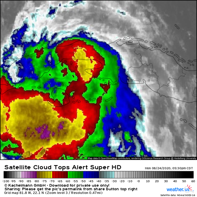
Looks like the center has reformed to the south.
- Attachments
-
-
srainhoutx

- Site Admin

- Posts: 19700
- Joined: Tue Feb 02, 2010 2:32 pm
- Location: Maggie Valley, NC
- Contact:
AF RECON may have just found the center right off the Western tip of Cuba. Extrapolated 995mb. Looks almost due W of an early center pass when the first arrved.
Carla/Alicia/Jerry(In The Eye)/Michelle/Charley/Ivan/Dennis/Katrina/Rita/Wilma/Humberto/Ike/Harvey
Member: National Weather Association
Facebook.com/Weather Infinity
Twitter @WeatherInfinity
Member: National Weather Association
Facebook.com/Weather Infinity
Twitter @WeatherInfinity
-
Texaspirate11

- Posts: 1278
- Joined: Tue Dec 31, 2013 12:24 am
- Contact:
i live near you and we are both in a voluntary evacuation area. Todville Road is historically known for flooding really badly.Txrunner82 wrote: ↑Mon Aug 24, 2020 10:32 pm I live in El Jardin in Seabrook. Basically end of Toddville rd. What should I do? Evac or hunker? Just moved to El Jardin so very worried about time frame now.
I'd consider it if Laura goes more West for sure
Just because you're disabled, you don't have to be a victim
Be Weather Aware & Prepared!
Barbara Jordan Winner in Media
Disability Integration Consultant
Be Weather Aware & Prepared!
Barbara Jordan Winner in Media
Disability Integration Consultant
-
Waded
- Posts: 81
- Joined: Wed Aug 23, 2017 12:32 pm
- Contact:
https://twitter.com/JackSillin/status/1 ... 9412859906
"For the fourth time in three days, #Laura is interacting with land this evening and has a strong mid-level center located at the northern edge of a persistent band of deep convection just south of the center.
In each other instance, this interaction produced a WSW shift in track"
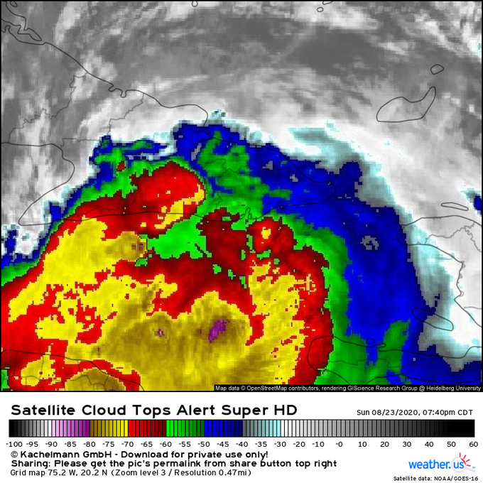
"For the fourth time in three days, #Laura is interacting with land this evening and has a strong mid-level center located at the northern edge of a persistent band of deep convection just south of the center.
In each other instance, this interaction produced a WSW shift in track"
-
dp6
- Posts: 116
- Joined: Sun May 24, 2020 5:32 pm
- Contact:
Storm surge map for Harris County:Txrunner82 wrote: ↑Mon Aug 24, 2020 10:32 pm I live in El Jardin in Seabrook. Basically end of Toddville rd. What should I do? Evac or hunker? Just moved to El Jardin so very worried about time frame now.
https://maps.redcross.org/website/maps/ ... _surge.pdf
Several mets on various forums have suggested Laura could reach Cat. 4. At least 1 has hinted at Cat. 5, though others have explained how factors make that unlikely in their view.
I could be wrong, but seem to recall that the average error for the official track is almost 100 miles this far out. Which could mean a real risk for Houston. If Laura's landfall is west of High Island (perhaps all the way to Matagorda or further west, depending on storm size and strength) it could pile a lot of water into Galveston Bay and against and over Seabrook. The worst case scenario is a very strong hurricane hitting west of Galveston, because of the direction of the winds that push the storm surge.
The saying is run from the waves, shelter from the winds.