
Late tonight is a start.
October: Chilly Halloween Outlook
-
DoctorMu

- Posts: 8034
- Joined: Sun Jun 28, 2015 11:58 am
- Location: College Station
- Contact:
-
Cpv17
- Posts: 7091
- Joined: Fri Aug 31, 2018 1:58 pm
- Location: El Campo/Wharton
- Contact:
Today could be the last of the upper 80’s/low 90’s till April.
-
Katdaddy

- Global Moderator

- Posts: 2521
- Joined: Thu Feb 04, 2010 8:18 am
- Location: League City, Tx
- Contact:
The cold front is moving into NW portions of SE TX early this morning with a line of thunderstorms. Additional showers and thunderstorms are developing across central portions of SE TX. Numerous showers and thunderstorms with very heavy rain remain offshore of the TX Coast. The line of thunderstorms will be moving through Houston during the morning commute. Temps will drop and skies will begin clearing later this morning and this afternoon. Lots of sun with highs in the 70s and lows in the 50s Tuesday and Wednesday before rain and thunderstorms arrive Thursday and Friday.
- Attachments
-
-
Cromagnum
- Posts: 3065
- Joined: Thu Feb 03, 2011 10:42 pm
- Location: Georgetown
- Contact:
Please do not screw up my morning flight...
-
Cromagnum
- Posts: 3065
- Joined: Thu Feb 03, 2011 10:42 pm
- Location: Georgetown
- Contact:
Dont like that echo south of Iowa Colony.

-
jasons2k

- Posts: 6194
- Joined: Thu Feb 04, 2010 12:54 pm
- Location: Imperial Oaks
- Contact:
The tornado up in Dallas was pretty bad. One of our longtime members on Storm2k took a direct hit. Prayers for those up in the Dallas area.
1.08” at my place.
1.08” at my place.
-
snowman65

- Posts: 1415
- Joined: Thu Feb 04, 2010 6:39 am
- Location: Orange, Tx
- Contact:
Is it possible for someone to show on a map, the path of the Dallas tornado last night? My son lives in Irving. I'm trying to find out how close this was to him...Thanks!
-
Texaspirate11

- Posts: 1278
- Joined: Tue Dec 31, 2013 12:24 am
- Contact:
Here is an article on the devastation of the tornado that hit Dallas yesterday.
Had a friend up there who said it was the worst she remembers.
https://www.msn.com/en-us/weather/topst ... spartanntp
Had a friend up there who said it was the worst she remembers.
https://www.msn.com/en-us/weather/topst ... spartanntp
Just because you're disabled, you don't have to be a victim
Be Weather Aware & Prepared!
Barbara Jordan Winner in Media
Disability Integration Consultant
Be Weather Aware & Prepared!
Barbara Jordan Winner in Media
Disability Integration Consultant
-
jasons2k
- Posts: 6194
- Joined: Thu Feb 04, 2010 12:54 pm
- Location: Imperial Oaks
- Contact:
Full coverage on Dallasnews.com
-
DoctorMu
- Posts: 8034
- Joined: Sun Jun 28, 2015 11:58 am
- Location: College Station
- Contact:
Chamber of Commerce weather today through Thursday.
Showers Thursday night and Friday before another cold front and a Chamber of Commerce weekend. It's been a long wait - so enjoy!
Showers Thursday night and Friday before another cold front and a Chamber of Commerce weekend. It's been a long wait - so enjoy!
-
jasons2k
- Posts: 6194
- Joined: Thu Feb 04, 2010 12:54 pm
- Location: Imperial Oaks
- Contact:
South Padre Island got rocked too. They are only allowing residents and business owners to cross the causeway and they may be without power for several days.
-
Katdaddy
- Global Moderator
- Posts: 2521
- Joined: Thu Feb 04, 2010 8:18 am
- Location: League City, Tx
- Contact:
Our Upper TX Coast weather ended peacefully with an Astro sunset but feel for our Dallas friends.
- Attachments
-
-
srainhoutx

- Site Admin

- Posts: 19700
- Joined: Tue Feb 02, 2010 2:32 pm
- Location: Maggie Valley, NC
- Contact:
We will need to monitor the late week forecast rather carefully. I'm not sure of the last time I have seen so much disagreement with the models at the 72 hour range. The GFS and NAM suggest a progressive upper trough and the attending cold front will sweep across Texas Thursday and exit the Coast Friday morning leaving us with a beautiful Fall weekend. On the other hand, The ECMWF and the Canadian develop a closed cut off upper low over New Mexico at the base of the upper trough and pump up a Coastal low/trough and rounds of thunderstorms and heavy rainfall that extend into Saturday. Hopefully we will get a better idea today of what the late week sensible may be.
- Attachments
-
-
Carla/Alicia/Jerry(In The Eye)/Michelle/Charley/Ivan/Dennis/Katrina/Rita/Wilma/Humberto/Ike/Harvey
Member: National Weather Association
Facebook.com/Weather Infinity
Twitter @WeatherInfinity
Member: National Weather Association
Facebook.com/Weather Infinity
Twitter @WeatherInfinity
-
snowman65
- Posts: 1415
- Joined: Thu Feb 04, 2010 6:39 am
- Location: Orange, Tx
- Contact:
Which one follows your "gut" feeling? The GFS has been pretty consistent the last several runs blowing it through Friday morning.srainhoutx wrote: ↑Tue Oct 22, 2019 8:23 am We will need to monitor the late week forecast rather carefully. I'm not sure of the last time I have seen so much disagreement with the models at the 72 hour range. The GFS and NAM suggest a progressive upper trough and the attending cold front will sweep across Texas Thursday and exit the Coast Friday morning leaving us with a beautiful Fall weekend. On the other hand, The ECMWF and the Canadian develop a closed cut off upper low over New Mexico at the base of the upper trough and pump up a Coastal low/trough and rounds of thunderstorms and heavy rainfall that extend into Saturday. Hopefully we will get a better idea today of what the late week sensible may be.
-
srainhoutx
- Site Admin
- Posts: 19700
- Joined: Tue Feb 02, 2010 2:32 pm
- Location: Maggie Valley, NC
- Contact:
Progressive seems to fit the pattern we have seen this Fall, but it is not unusual to see cut off upper lows develop across the Desert SW this time of year. Personally I am hoping for a progressive pattern so we have a nice calm Fall weekend.
Carla/Alicia/Jerry(In The Eye)/Michelle/Charley/Ivan/Dennis/Katrina/Rita/Wilma/Humberto/Ike/Harvey
Member: National Weather Association
Facebook.com/Weather Infinity
Twitter @WeatherInfinity
Member: National Weather Association
Facebook.com/Weather Infinity
Twitter @WeatherInfinity
-
tireman4

- Global Moderator
- Posts: 7132
- Joined: Wed Feb 03, 2010 9:24 pm
- Location: Humble, Texas
- Contact:
000
FXUS64 KHGX 221451
AFDHGX
Area Forecast Discussion
National Weather Service Houston/Galveston TX
951 AM CDT Tue Oct 22 2019
.UPDATE...
Only change for the morning update was to extend the Small Craft
Advisory in the offshore waters into this afternoon based on
latest observations. Everything else looks good. 47
&&
.PRELIMINARY POINT TEMPS/POPS...
College Station (CLL) 79 53 82 58 79 / 0 0 0 0 30
Houston (IAH) 80 54 80 60 78 / 0 0 0 0 30
Galveston (GLS) 78 67 79 70 78 / 0 0 0 10 30
&&
.HGX WATCHES/WARNINGS/ADVISORIES...
TX...NONE.
GM...SMALL CRAFT SHOULD EXERCISE CAUTION until 10 AM CDT this morning
for the following zones: Galveston Bay...Matagorda Bay.
Small Craft Advisory until 10 AM CDT this morning for the
following zones: Coastal waters from Freeport to Matagorda
Ship Channel TX out 20 NM...Coastal waters from High Island
to Freeport TX out 20 NM.
SMALL CRAFT SHOULD EXERCISE CAUTION until 4 PM CDT this
afternoon for the following zones: Coastal waters from
Freeport to Matagorda Ship Channel TX out 20 NM...Coastal
waters from High Island to Freeport TX out 20 NM.
Small Craft Advisory until 4 PM CDT this afternoon for the
following zones: Waters from Freeport to Matagorda Ship
Channel TX from 20 to 60 NM...Waters from High Island to
Freeport TX from 20 to 60 NM.
&&
-
Cpv17
- Posts: 7091
- Joined: Fri Aug 31, 2018 1:58 pm
- Location: El Campo/Wharton
- Contact:
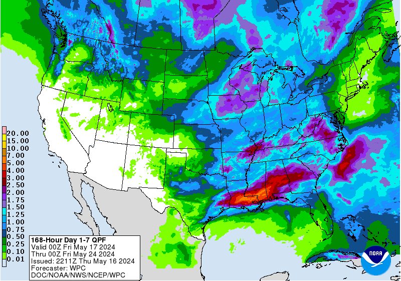
The latest WPC forecast has 3-5” for most of southeast TX over the next week!!
-
srainhoutx
- Site Admin
- Posts: 19700
- Joined: Tue Feb 02, 2010 2:32 pm
- Location: Maggie Valley, NC
- Contact:
Wednesday morning weather briefing from Jeff:
A strong storm system will effect TX the end of this week.
Cool high pressure will shift toward the east over the next 24 hours allowing Gulf moisture to make a return to the area ahead of a strong upper level storm system that will develop over the southern plains on Friday. While there has been very significant model differences in the handling of this feature over the last few days, models have started to trend toward a compromise situation and highlight Friday as the big weather day with this event. Moisture will return on Thursday and may start to see showers and thunderstorms develop and move inland from the Gulf of Mexico late in the day.
Thursday night/Friday:
A weak coastal low will develop and begin to move NE along the TX coast allowing deep tropical moisture to surge into the region. The fastest NAM and GFS model solutions move a strong cold front across the area Friday morning with showers and thunderstorms ending before noon while the ECMWF has the front Friday evening and the CMC on Saturday morning. The NAM and GFS are the drier models as they blast the front through quickly and end rainfall by noon Friday while the ECMWF and certainly the CMC are wettest with their delayed frontal passage. The models are starting to hone in on Friday being the day of the frontal passage, but it could be early or late in the day. The later the frontal passage the greater the rainfall amounts with the ECMWF showing widespread 2-3 inches over the coastal areas of SE TX on Friday as the coastal low gets close to the coast and is able to linger the longest while the GFS is showing maybe .50 of an inch.
What actually happens likely lies into between these two models camps with a cold front likely Friday afternoon with heavy rains in the morning into the afternoon hours on Friday. Should the CMC be correct, heavy rainfall would continue Friday night and into Saturday morning.
Additionally these strong cold fronts with decent cold air tend to move faster than the global model guidance suggests many times and the NAM may have the better handle on the situation which shows the fastest frontal passage and rain ending Friday morning.
Rainfall amounts of 1-2 inches will be possible over the region and WPC has place a good portion of SE TX in a slight risk for excessive rainfall on Friday. Some minor flooding (street) will be possible during the morning commute on Friday. Some strong storms will also be possible especially near the coast with the track of the surface coastal low.
Tropics:
A tropical disturbance over central America will move into the SW Gulf of Mexico on Thursday where conditions may be favorable for a brief tropical system to forms. NHC current gives the system a 20% chance of development before a strong cold front moves off the TX coast Friday or Saturday. Some of the moisture associated with this feature may get drawn NNE along the TX coast ahead of the Friday cold front helping to enhance rainfall amounts.
- Attachments
-
Carla/Alicia/Jerry(In The Eye)/Michelle/Charley/Ivan/Dennis/Katrina/Rita/Wilma/Humberto/Ike/Harvey
Member: National Weather Association
Facebook.com/Weather Infinity
Twitter @WeatherInfinity
Member: National Weather Association
Facebook.com/Weather Infinity
Twitter @WeatherInfinity
-
snowman65
- Posts: 1415
- Joined: Thu Feb 04, 2010 6:39 am
- Location: Orange, Tx
- Contact:
I need everyones collective energy to push the front through as early and as dry as possible...I have plans!!!
-
srainhoutx
- Site Admin
- Posts: 19700
- Joined: Tue Feb 02, 2010 2:32 pm
- Location: Maggie Valley, NC
- Contact:
Looking ahead to Halloween, there are some suggestions that some stormy weather and possibly the coldest air of the Fall Season arrives as October ends. I am closely following the extended guidance. We need to get a trailer load to Haywood County early in November and the movers on their way somewhere around the 10th.
- Attachments
-
Carla/Alicia/Jerry(In The Eye)/Michelle/Charley/Ivan/Dennis/Katrina/Rita/Wilma/Humberto/Ike/Harvey
Member: National Weather Association
Facebook.com/Weather Infinity
Twitter @WeatherInfinity
Member: National Weather Association
Facebook.com/Weather Infinity
Twitter @WeatherInfinity