
https://www.tropicaltidbits.com/analysi ... 1412&fh=72
Icon model has 15 plus inches of rain
September 2019 - Warm End of September
-
stormlover
- Posts: 439
- Joined: Wed Dec 04, 2013 10:21 am
- Location: Lumberton TX
- Contact:
-
srainhoutx

- Site Admin

- Posts: 19700
- Joined: Tue Feb 02, 2010 2:32 pm
- Location: Maggie Valley, NC
- Contact:
Hurricane Hunter missions for the Gulf disturbance have been tasked with the first mission scheduled for tomorrow afternoon/evening...
Code: Select all
WEATHER RECONNAISSANCE FLIGHTS
CARCAH, NATIONAL HURRICANE CENTER, MIAMI, FL.
1115 AM EDT SAT 14 SEPTEMBER 2019
SUBJECT: TROPICAL CYCLONE PLAN OF THE DAY (TCPOD)
         VALID 15/1100Z TO 16/1100Z SEPTEMBER 2019
         TCPOD NUMBER.....19-109

I.  ATLANTIC REQUIREMENTS
    1. TROPICAL STORM HUMBERTO
       FLIGHT ONE - NOAA 42          FLIGHT TWO - TEAL 72
       A. 15/2230Z                   A. 15/2330Z
       B. NOAA2 0909A HUMBERTO       B. AFXXX 1009A HUMBERTO
       C. 15/2100Z                   C. 15/2115Z
       D. 29.4N 78.0W                D. 29.5N 78.0W
       E. 15/2200Z TO 16/0300Z       E. 15/2300Z TO 16/0230Z
       F. SFC TO 15,000 FT           F. SFC TO 15,000 FT

       FLIGHT THREE - TEAL 73
       A. 16/1130Z
       B. AFXXX 1109A HUMBERTO
       C. 16/0900Z
       D. 30.0N 77.0W
       E. 16/1100Z TO 16/1430Z
       F. SFC TO 10,000 FT

    2. SUSPECT AREA (WESTERN GULF OF MEXICO)
       FLIGHT ONE - TEAL 74          FLIGHT TWO - TEAL 75
       A. 15/2000Z                   A. 16/1130Z,1730Z
       B. AFXXX 01DDA INVEST         B. AFXXX 0210A CYCLONE
       C. 15/1830Z                   C. 16/0945Z
       D. 25.0N 94.5W                D. 26.0N 96.0W
       E. 15/1930Z TO 15/2330Z       E. 16/1100Z TO 16/1730Z
       F. SFC TO 10,000 FT           F. SFC TO 10,000 FT

    3. OUTLOOK FOR SUCCEEDING DAY:
       A. CONTINUE 12-HRLY FIXES INTO HUMBERTO WHILE SYSTEM
          REMAINS A THREAT.
       B. CONTINUE 6-HRLY FIXES INTO SUSPECT AREA IN WESTERN
          GULF OF MEXICO IF SYSTEM DEVELOPS AND IS A THREAT.

    4. REMARK: THE MISSION TASKED ON TCPOD 19-108 INTO THE
       SUSPECT AREA EAST OF THE WINDWARD ISLANDS WAS
       CANCELED BY NHC AT 14/0800Z.

II. PACIFIC REQUIREMENTS
    1. NEGATIVE RECONNAISSANCE REQUIREMENTS.
    2. OUTLOOK FOR SUCCEEDING DAY.....NEGATIVE.

$$
WJM
Carla/Alicia/Jerry(In The Eye)/Michelle/Charley/Ivan/Dennis/Katrina/Rita/Wilma/Humberto/Ike/Harvey
Member: National Weather Association
Facebook.com/Weather Infinity
Twitter @WeatherInfinity
Member: National Weather Association
Facebook.com/Weather Infinity
Twitter @WeatherInfinity
-
sambucol

- Posts: 1244
- Joined: Wed Feb 03, 2010 5:43 pm
- Location: Mont Belvieu
- Contact:
When will the rain start in our area?
-
Rip76

- Posts: 2129
- Joined: Mon Feb 15, 2010 12:38 am
- Location: The Woodlands
- Contact:
-
Cromagnum
- Posts: 3065
- Joined: Thu Feb 03, 2011 10:42 pm
- Location: Georgetown
- Contact:
Hoping for lots of rain and soon lots of cold. This hot BS has worn out it's welcome.
-
Cpv17
- Posts: 7091
- Joined: Fri Aug 31, 2018 1:58 pm
- Location: El Campo/Wharton
- Contact:
I’ll pass on that model. Only has me getting two inches lol the flooding rain threat is there though. Some of the models are coming onboard with 5+ inches over a widespread area.stormlover wrote: ↑Sat Sep 14, 2019 11:19 am https://www.tropicaltidbits.com/analysi ... 1412&fh=72
Icon model has 15 plus inches of rain
-
DoctorMu

- Posts: 8030
- Joined: Sun Jun 28, 2015 11:58 am
- Location: College Station
- Contact:
About 50% chance Wed and Thursday now in CLL. Highs in the upper 80s. Fingers crossed.jasons wrote: ↑Sat Sep 14, 2019 8:45 am Looks like your initial 40% was pretty spot-on
I just want rain (but not flooding). I’m only asking the weather gods the thread a needle for us lol
Stout band out in the Gulf this morning on our local radar. The NWS has increased our rain chances for next week, topping out at 60% on Wednesday.
-
DoctorMu
- Posts: 8030
- Joined: Sun Jun 28, 2015 11:58 am
- Location: College Station
- Contact:
We've had 2.9 in of rain since June 30.
Some are doing even worse.
Some are doing even worse.
-
srainhoutx
- Site Admin
- Posts: 19700
- Joined: Tue Feb 02, 2010 2:32 pm
- Location: Maggie Valley, NC
- Contact:
The afternoon Updated WPC Quantitative Precipitation Forecast suggests the best chances of rain begin Monday afternoon/evening continuing into Tuesday. The Wednesday/Thursday timeframe looks to bring increasing chance of rain even into the Hill Country. The highest concentration of rainfall over the 5 day period is focused along the Middle Texas Coast.
Carla/Alicia/Jerry(In The Eye)/Michelle/Charley/Ivan/Dennis/Katrina/Rita/Wilma/Humberto/Ike/Harvey
Member: National Weather Association
Facebook.com/Weather Infinity
Twitter @WeatherInfinity
Member: National Weather Association
Facebook.com/Weather Infinity
Twitter @WeatherInfinity
-
Cpv17
- Posts: 7091
- Joined: Fri Aug 31, 2018 1:58 pm
- Location: El Campo/Wharton
- Contact:
The 12z Euro came in weaker than the 0z run. Way less rainfall than the 0z run. Basically has nothing north of 10.
-
DoctorMu
- Posts: 8030
- Joined: Sun Jun 28, 2015 11:58 am
- Location: College Station
- Contact:
Canadian brings the rain mostly west of Houston, from Victoria through CLL. Individual models, not surprisingly still struggling. However, GEFS and GEPS Ensembles are also wildly different. ICON as mentioned is a coastal deluge.
It's a crapshoot currently, at the edge of the 5 day forecast. We'll see.

-
Cpv17
- Posts: 7091
- Joined: Fri Aug 31, 2018 1:58 pm
- Location: El Campo/Wharton
- Contact:
I wouldn’t get your hopes up.DoctorMu wrote: ↑Sat Sep 14, 2019 2:36 pmCanadian brings the rain mostly west of Houston, from Victoria through CLL. Individual models, not surprisingly still struggling. However, GEFS and GEPS Ensembles are also wildly different. ICON as mentioned is a coastal deluge.
It's a crapshoot currently, at the edge of the 5 day forecast. We'll see.
-
cperk
- Posts: 857
- Joined: Sun Aug 19, 2012 12:09 pm
- Location: Richmond
- Contact:
-
Cpv17
- Posts: 7091
- Joined: Fri Aug 31, 2018 1:58 pm
- Location: El Campo/Wharton
- Contact:
-
srainhoutx
- Site Admin
- Posts: 19700
- Joined: Tue Feb 02, 2010 2:32 pm
- Location: Maggie Valley, NC
- Contact:
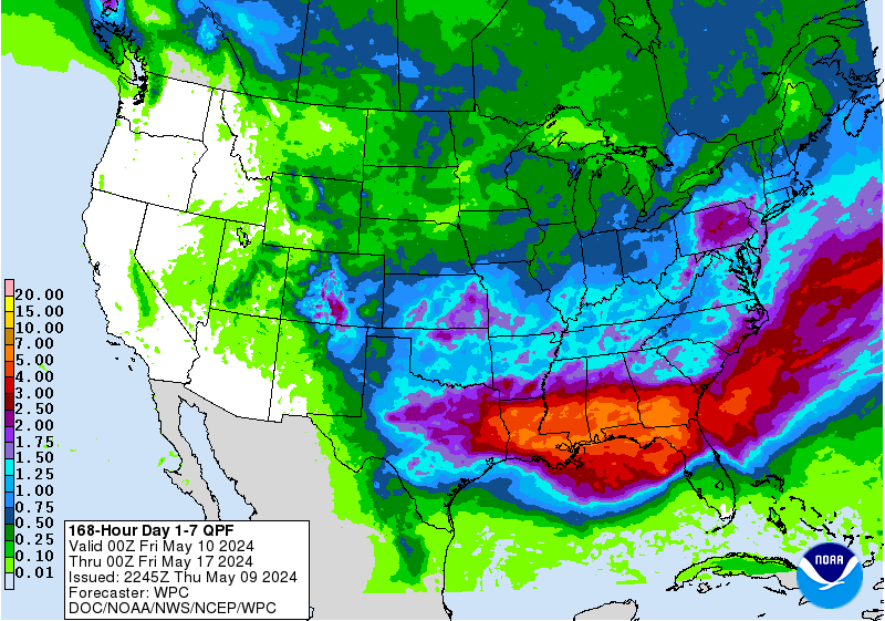
The WPC QPF graphics just Updated. Here is the totals for 7 Days.
- Attachments
-
Carla/Alicia/Jerry(In The Eye)/Michelle/Charley/Ivan/Dennis/Katrina/Rita/Wilma/Humberto/Ike/Harvey
Member: National Weather Association
Facebook.com/Weather Infinity
Twitter @WeatherInfinity
Member: National Weather Association
Facebook.com/Weather Infinity
Twitter @WeatherInfinity
-
Cpv17
- Posts: 7091
- Joined: Fri Aug 31, 2018 1:58 pm
- Location: El Campo/Wharton
- Contact:
I’ll take it. I like how the bigger totals are aimed more towards me sw of Houston lol
-
jasons2k

- Posts: 6193
- Joined: Thu Feb 04, 2010 12:54 pm
- Location: Imperial Oaks
- Contact:
Deep thoughts by Jack Handey:
Seems like when these systems impact Louisiana/MS/AL, there is still a lot of rain well north and east of the center. And when systems come in the Middle or Lower Texas coast, the moisture just hugs the center or stays just offshore. I don’t get it. It’s not like we have some physical barrier over SE Texas that would stop the rain, but it stops anyway.
Seems like when these systems impact Louisiana/MS/AL, there is still a lot of rain well north and east of the center. And when systems come in the Middle or Lower Texas coast, the moisture just hugs the center or stays just offshore. I don’t get it. It’s not like we have some physical barrier over SE Texas that would stop the rain, but it stops anyway.
-
djmike

- Posts: 1876
- Joined: Fri Jan 07, 2011 12:19 pm
- Location: BEAUMONT, TX
- Contact:
Yup. Its usually N/NE thats has copious amounts of rain and possible flooding with tropical systems, but the ones that near TX, heck this barely gives me any rain here in Beaumont. I have not had a drop in 3 weeks! My grass is crunchy, plants are withering and its starting to look like 2011 here all over again. Hope this system becomes a low end depression and comes on shore near Galveston. That would suffice Hou/Bmnt with plenty of refreshing moisture.
Mike
Beaumont, TX
(IH-10 & College Street)
Beaumont, TX
(IH-10 & College Street)
-
869MB
- Posts: 206
- Joined: Fri Oct 30, 2015 8:44 am
- Location: Katy, TX
- Contact:
I think he summed it up perfectly. I've noticed the same thing over the years. Whenever it comes to SE Texas, it's always something...Either a sharp offshore coastal trough develops, thus bottling up all the moisture offshore...Or a short wave moving across the state just in the nick time of time to shunt all of the moisture to the east and southeast of the region into Louisiana or the Gulf...Or a tropical wave moving toward the area that wraps up into an organized system taking all of the moisture into Louisiana...Or a stout area of high pressure that builds in from the north and shunts all of the moisture into South Texas and Mexico...Pick one, I've seen all of these scenarios over the years.jasons wrote: ↑Sat Sep 14, 2019 4:22 pm Deep thoughts by Jack Handey:
Seems like when these systems impact Louisiana/MS/AL, there is still a lot of rain well north and east of the center. And when systems come in the Middle or Lower Texas coast, the moisture just hugs the center or stays just offshore. I don’t get it. It’s not like we have some physical barrier over SE Texas that would stop the rain, but it stops anyway.
However, maybe this system will be different for our area. We shall see.
-
stormlover
- Posts: 439
- Joined: Wed Dec 04, 2013 10:21 am
- Location: Lumberton TX
- Contact:
Will know more by tomorrow night, models been going back and forth