
Hurricane Allen was a large hurricane on top of it. I have seen satellite images. I can see why it caused quite a scare on the level of Gilbert and Rita.869MB wrote: ↑Sun Sep 01, 2019 5:02 pmAnd STILL trails 1980 Hurricane Allen with respect to highest sustained winds recorded within the Atlantic Ocean basin. This should make everyone respect Hurricane Allen even more. A truly remarkable hurricane in itself.Ptarmigan wrote: ↑Sun Sep 01, 2019 4:23 pmhttps://www.nhc.noaa.gov/text/refresh/M ... 2055.shtmlCode: Select all
054
WTNT35 KNHC 012055
TCPAT5

BULLETIN
Hurricane Dorian Advisory Number  34
NWS National Hurricane Center Miami FL       AL052019
500 PM EDT Sun Sep 01 2019

...EYE OF CATASTROPHIC HURRICANE DORIAN CRAWLING OVER THE ABACOS
ISLANDS IN THE BAHAMAS...
...DORIAN'S FURY NOW AIMING TOWARD GRAND BAHAMA...


SUMMARY OF 500 PM EDT...2100 UTC...INFORMATION
----------------------------------------------
LOCATION...26.6N 77.3W
ABOUT 95 MI...150 KM E OF FREEPORT GRAND BAHAMA ISLAND
ABOUT 175 MI...280 KM E OF WEST PALM BEACH FLORIDA
MAXIMUM SUSTAINED WINDS...185 MPH...295 KM/H
PRESENT MOVEMENT...W OR 270 DEGREES AT 5 MPH...7 KM/H
MINIMUM CENTRAL PRESSURE...910 MB...26.88 INCHES


WATCHES AND WARNINGS
--------------------
CHANGES WITH THIS ADVISORY:

A Storm Surge Warning has been issued from Lantana to the
Volusia/Brevard County Line.

A Storm Surge Watch has been issued from the Volusia/Brevard County
Line to the Flagler/Volusia County Line.

A Hurricane Warning has been issued from Jupiter Inlet to the
Volusia/Brevard County Line.

A Hurricane Watch has been issued from the Volusia/Brevard County
Line to the Flagler/Volusia County Line

SUMMARY OF WATCHES AND WARNINGS IN EFFECT:

A Storm Surge Warning is in effect for...
* Lantana to the Volusia/Brevard County Line

A Storm Surge Watch is in effect for...
* North of Deerfield Beach to Lantana
* Volusia/Brevard County Line to the Flagler/Volusia County Line

A Hurricane Warning is in effect for...
* Northwestern Bahamas excluding Andros Island
* Jupiter Inlet to the Volusia/Brevard County Line

A Hurricane Watch is in effect for...
* Andros Island
* North of Deerfield Beach to Jupiter Inlet
* Volusia/Brevard County Line to the Flagler/Volusia County Line

A Tropical Storm Warning is in effect for...
* North of Deerfield Beach to Jupiter Inlet

A Tropical Storm Watch is in effect for...
* North of Golden Beach to Deerfield Beach
* Lake Okeechobee

A Storm Surge Warning means there is a danger of life-threatening
inundation, from rising water moving inland from the coastline,
during the next 36 hours in the indicated locations. For a
depiction of areas at risk, please see the National Weather
Service Storm Surge Watch/Warning Graphic, available at
hurricanes.gov.  This is a life-threatening situation.  Persons
located within these areas should take all necessary actions to
protect life and property from rising water and the potential for
other dangerous conditions.  Promptly follow evacuation and other
instructions from local officials.

A Storm Surge Watch means there is a possibility of life-
threatening inundation, from rising water moving inland from the
coastline, in the indicated locations during the next 48 hours.

A Hurricane Warning means that hurricane conditions are expected
somewhere within the warning area. Preparations to protect life and
property should be rushed to completion.

A Hurricane Watch means that hurricane conditions are possible
within the watch area.  A watch is typically issued 48 hours
before the anticipated first occurrence of tropical-storm-force
winds, conditions that make outside preparations difficult or
dangerous.

A Tropical Storm Warning means that tropical storm conditions are
expected within the warning area within 36 hours.

A Tropical Storm Watch means that tropical storm conditions are
possible within the watch area, generally within 48 hours.

Interests elsewhere along the east coast of Florida should continue
to monitor the progress of Dorian, as additional watches or
warnings may be required later today.

For storm information specific to your area in the United
States, including possible inland watches and warnings, please
monitor products issued by your local National Weather Service
forecast office. For storm information specific to your area
outside of the United States, please monitor products issued by
your national meteorological service.


DISCUSSION AND OUTLOOK
----------------------
At 500 PM EDT (2100 UTC), the distinct eye of Hurricane Dorian was
located near latitude 26.6 North, longitude 77.3 West. Dorian is
moving toward the west near 5 mph (7 km/h). A slower westward
to west-northwestward motions should continue for the next day or
two, followed by a gradual turn toward the northwest.  On this
track, the core of extremely dangerous Hurricane Dorian will
continue to pound Great Abaco this evening and move near or
over Grand Bahama Island tonight and Monday. The hurricane will
move dangerously close to the Florida east coast late Monday through
Tuesday night.

Maximum sustained winds are near 185 mph (295 km/h) with higher
gusts.  Dorian is a category 5 hurricane on the Saffir-Simpson
Hurricane Wind Scale.  Some fluctuations in intensity are likely,
and Dorian is expected to remain a catastrophic hurricane during the
next few days.

Hurricane-force winds extend outward up to 45 miles (75 km) from the
center and tropical-storm-force winds extend outward up to 140 miles
(220 km).

The last minimum central pressure measured by an Air Force
reconnaissance plane a couple of hours ago was 910 mb (26.88
inches).


HAZARDS AFFECTING LAND
----------------------
WIND:  Catastrophic hurricane conditions are occurring in the Abacos
Islands and will spread across Grand Bahama Island tonight. Do not
venture out into the eye, as winds will suddenly increase as the eye
passes.

Hurricane conditions are expected within the hurricane warning area
in Florida by late Monday or Tuesday.

Tropical storm conditions are expected within the tropical storm
warning area on Monday and Tuesday and are possible in the tropical
storm watch area by Monday night.

STORM SURGE:  A life-threatening storm surge will raise water levels
by as much as 18 to 23 feet above normal tide levels in areas of
onshore winds on the Abaco Islands and Grand Bahama Island.  Near
the coast, the surge will be accompanied by large and destructive
waves.

The combination of a dangerous storm surge and the tide will cause
normally dry areas near the coast to be flooded by rising waters
moving inland from the shoreline. The water could reach the
following heights above ground somewhere in the indicated
areas if the peak surge occurs at the time of high tide...

Volusia/Brevard County Line to Jupiter Inlet FL...4 to 7 ft
North of Deerfield Beach to Jupiter Inlet FL...2 to 4 ft

The surge will be accompanied by large and destructive waves.
Surge-related flooding depends on the how close the center of
Dorian comes to the Florida east coast, and can vary greatly over
short distances.  For information specific to your area, please see
products issued by your local National Weather Service forecast
office.

RAINFALL:  Dorian is expected to produce the following rainfall
totals through late this week:

Northwestern Bahamas...12 to 24 inches, isolated 30 inches.
Coastal Carolinas...5 to 10 inches, isolated 15 inches.
The Atlantic Coast from the Florida peninsula through Georgia...3 to
6 inches, isolated 9 inches.
Southeastern Virginia...2 to 4 inches, isolated 6 inches.
Central Bahamas...2 to 4 inches, isolated 6 inches.

This rainfall may cause life-threatening flash floods.

SURF:  Large swells are already affecting east-facing shores of the
Bahamas, the Florida east coast, and will spread northward along the
southeastern United States coast during the next few days.  These
swells are likely to cause life-threatening surf and rip current
conditions.  Please consult products from your local weather office.


NEXT ADVISORY
-------------
Next intermediate advisory at 800 PM EDT.
Next complete advisory at 1100 PM EDT.

$$
Forecaster Avila
Hurricane Dorian now has 185 mph winds!

September 2019 - Warm End of September
-
Ptarmigan

- Statistical Specialist

- Posts: 4505
- Joined: Wed Feb 03, 2010 7:20 pm
- Contact:
-
869MB
- Posts: 206
- Joined: Fri Oct 30, 2015 8:44 am
- Location: Katy, TX
- Contact:
And the first Atlantic hurricane on record to achieve Category 5 status on three separate occasions (2004 Hurricane Ivan would later be the second one).Ptarmigan wrote: ↑Sun Sep 01, 2019 5:30 pmHurricane Allen was a large hurricane on top of it. I have seen satellite images. I can see why it caused quite a scare on the level of Gilbert and Rita.869MB wrote: ↑Sun Sep 01, 2019 5:02 pmAnd STILL trails 1980 Hurricane Allen with respect to highest sustained winds recorded within the Atlantic Ocean basin. This should make everyone respect Hurricane Allen even more. A truly remarkable hurricane in itself.Ptarmigan wrote: ↑Sun Sep 01, 2019 4:23 pmhttps://www.nhc.noaa.gov/text/refresh/M ... 2055.shtmlCode: Select all
054
WTNT35 KNHC 012055
TCPAT5

BULLETIN
Hurricane Dorian Advisory Number  34
NWS National Hurricane Center Miami FL       AL052019
500 PM EDT Sun Sep 01 2019

...EYE OF CATASTROPHIC HURRICANE DORIAN CRAWLING OVER THE ABACOS
ISLANDS IN THE BAHAMAS...
...DORIAN'S FURY NOW AIMING TOWARD GRAND BAHAMA...


SUMMARY OF 500 PM EDT...2100 UTC...INFORMATION
----------------------------------------------
LOCATION...26.6N 77.3W
ABOUT 95 MI...150 KM E OF FREEPORT GRAND BAHAMA ISLAND
ABOUT 175 MI...280 KM E OF WEST PALM BEACH FLORIDA
MAXIMUM SUSTAINED WINDS...185 MPH...295 KM/H
PRESENT MOVEMENT...W OR 270 DEGREES AT 5 MPH...7 KM/H
MINIMUM CENTRAL PRESSURE...910 MB...26.88 INCHES


WATCHES AND WARNINGS
--------------------
CHANGES WITH THIS ADVISORY:

A Storm Surge Warning has been issued from Lantana to the
Volusia/Brevard County Line.

A Storm Surge Watch has been issued from the Volusia/Brevard County
Line to the Flagler/Volusia County Line.

A Hurricane Warning has been issued from Jupiter Inlet to the
Volusia/Brevard County Line.

A Hurricane Watch has been issued from the Volusia/Brevard County
Line to the Flagler/Volusia County Line

SUMMARY OF WATCHES AND WARNINGS IN EFFECT:

A Storm Surge Warning is in effect for...
* Lantana to the Volusia/Brevard County Line

A Storm Surge Watch is in effect for...
* North of Deerfield Beach to Lantana
* Volusia/Brevard County Line to the Flagler/Volusia County Line

A Hurricane Warning is in effect for...
* Northwestern Bahamas excluding Andros Island
* Jupiter Inlet to the Volusia/Brevard County Line

A Hurricane Watch is in effect for...
* Andros Island
* North of Deerfield Beach to Jupiter Inlet
* Volusia/Brevard County Line to the Flagler/Volusia County Line

A Tropical Storm Warning is in effect for...
* North of Deerfield Beach to Jupiter Inlet

A Tropical Storm Watch is in effect for...
* North of Golden Beach to Deerfield Beach
* Lake Okeechobee

A Storm Surge Warning means there is a danger of life-threatening
inundation, from rising water moving inland from the coastline,
during the next 36 hours in the indicated locations. For a
depiction of areas at risk, please see the National Weather
Service Storm Surge Watch/Warning Graphic, available at
hurricanes.gov.  This is a life-threatening situation.  Persons
located within these areas should take all necessary actions to
protect life and property from rising water and the potential for
other dangerous conditions.  Promptly follow evacuation and other
instructions from local officials.

A Storm Surge Watch means there is a possibility of life-
threatening inundation, from rising water moving inland from the
coastline, in the indicated locations during the next 48 hours.

A Hurricane Warning means that hurricane conditions are expected
somewhere within the warning area. Preparations to protect life and
property should be rushed to completion.

A Hurricane Watch means that hurricane conditions are possible
within the watch area.  A watch is typically issued 48 hours
before the anticipated first occurrence of tropical-storm-force
winds, conditions that make outside preparations difficult or
dangerous.

A Tropical Storm Warning means that tropical storm conditions are
expected within the warning area within 36 hours.

A Tropical Storm Watch means that tropical storm conditions are
possible within the watch area, generally within 48 hours.

Interests elsewhere along the east coast of Florida should continue
to monitor the progress of Dorian, as additional watches or
warnings may be required later today.

For storm information specific to your area in the United
States, including possible inland watches and warnings, please
monitor products issued by your local National Weather Service
forecast office. For storm information specific to your area
outside of the United States, please monitor products issued by
your national meteorological service.


DISCUSSION AND OUTLOOK
----------------------
At 500 PM EDT (2100 UTC), the distinct eye of Hurricane Dorian was
located near latitude 26.6 North, longitude 77.3 West. Dorian is
moving toward the west near 5 mph (7 km/h). A slower westward
to west-northwestward motions should continue for the next day or
two, followed by a gradual turn toward the northwest.  On this
track, the core of extremely dangerous Hurricane Dorian will
continue to pound Great Abaco this evening and move near or
over Grand Bahama Island tonight and Monday. The hurricane will
move dangerously close to the Florida east coast late Monday through
Tuesday night.

Maximum sustained winds are near 185 mph (295 km/h) with higher
gusts.  Dorian is a category 5 hurricane on the Saffir-Simpson
Hurricane Wind Scale.  Some fluctuations in intensity are likely,
and Dorian is expected to remain a catastrophic hurricane during the
next few days.

Hurricane-force winds extend outward up to 45 miles (75 km) from the
center and tropical-storm-force winds extend outward up to 140 miles
(220 km).

The last minimum central pressure measured by an Air Force
reconnaissance plane a couple of hours ago was 910 mb (26.88
inches).


HAZARDS AFFECTING LAND
----------------------
WIND:  Catastrophic hurricane conditions are occurring in the Abacos
Islands and will spread across Grand Bahama Island tonight. Do not
venture out into the eye, as winds will suddenly increase as the eye
passes.

Hurricane conditions are expected within the hurricane warning area
in Florida by late Monday or Tuesday.

Tropical storm conditions are expected within the tropical storm
warning area on Monday and Tuesday and are possible in the tropical
storm watch area by Monday night.

STORM SURGE:  A life-threatening storm surge will raise water levels
by as much as 18 to 23 feet above normal tide levels in areas of
onshore winds on the Abaco Islands and Grand Bahama Island.  Near
the coast, the surge will be accompanied by large and destructive
waves.

The combination of a dangerous storm surge and the tide will cause
normally dry areas near the coast to be flooded by rising waters
moving inland from the shoreline. The water could reach the
following heights above ground somewhere in the indicated
areas if the peak surge occurs at the time of high tide...

Volusia/Brevard County Line to Jupiter Inlet FL...4 to 7 ft
North of Deerfield Beach to Jupiter Inlet FL...2 to 4 ft

The surge will be accompanied by large and destructive waves.
Surge-related flooding depends on the how close the center of
Dorian comes to the Florida east coast, and can vary greatly over
short distances.  For information specific to your area, please see
products issued by your local National Weather Service forecast
office.

RAINFALL:  Dorian is expected to produce the following rainfall
totals through late this week:

Northwestern Bahamas...12 to 24 inches, isolated 30 inches.
Coastal Carolinas...5 to 10 inches, isolated 15 inches.
The Atlantic Coast from the Florida peninsula through Georgia...3 to
6 inches, isolated 9 inches.
Southeastern Virginia...2 to 4 inches, isolated 6 inches.
Central Bahamas...2 to 4 inches, isolated 6 inches.

This rainfall may cause life-threatening flash floods.

SURF:  Large swells are already affecting east-facing shores of the
Bahamas, the Florida east coast, and will spread northward along the
southeastern United States coast during the next few days.  These
swells are likely to cause life-threatening surf and rip current
conditions.  Please consult products from your local weather office.


NEXT ADVISORY
-------------
Next intermediate advisory at 800 PM EDT.
Next complete advisory at 1100 PM EDT.

$$
Forecaster Avila
Hurricane Dorian now has 185 mph winds!
-
Texaspirate11

- Posts: 1278
- Joined: Tue Dec 31, 2013 12:24 am
- Contact:
Horrific pictures out of Abacos.
Just because you're disabled, you don't have to be a victim
Be Weather Aware & Prepared!
Barbara Jordan Winner in Media
Disability Integration Consultant
Be Weather Aware & Prepared!
Barbara Jordan Winner in Media
Disability Integration Consultant
-
srainhoutx

- Site Admin

- Posts: 19700
- Joined: Tue Feb 02, 2010 2:32 pm
- Location: Maggie Valley, NC
- Contact:
Our friend and 53rd Meteorologist Garrett Black posted this on his Twitter feed from this morning as Dorian was nearing Abaco.
- Attachments
-
Carla/Alicia/Jerry(In The Eye)/Michelle/Charley/Ivan/Dennis/Katrina/Rita/Wilma/Humberto/Ike/Harvey
Member: National Weather Association
Facebook.com/Weather Infinity
Twitter @WeatherInfinity
Member: National Weather Association
Facebook.com/Weather Infinity
Twitter @WeatherInfinity
-
Scott747
- Posts: 1647
- Joined: Tue Feb 23, 2010 9:56 am
- Location: Freeport/Surfside Beach
- Contact:
After working with Josh for over a decade now and, I think I have a decent amount of knowledge about damage , destruction etc....Cpv17 wrote: ↑Sun Sep 01, 2019 1:51 pmI’m surprised the damage isn’t worse than that. Homes are still intact for the most part.Rip76 wrote: ↑Sun Sep 01, 2019 1:43 pm Wow, heartbreaking
https://mobile.twitter.com/julmisjames/ ... 5718568960
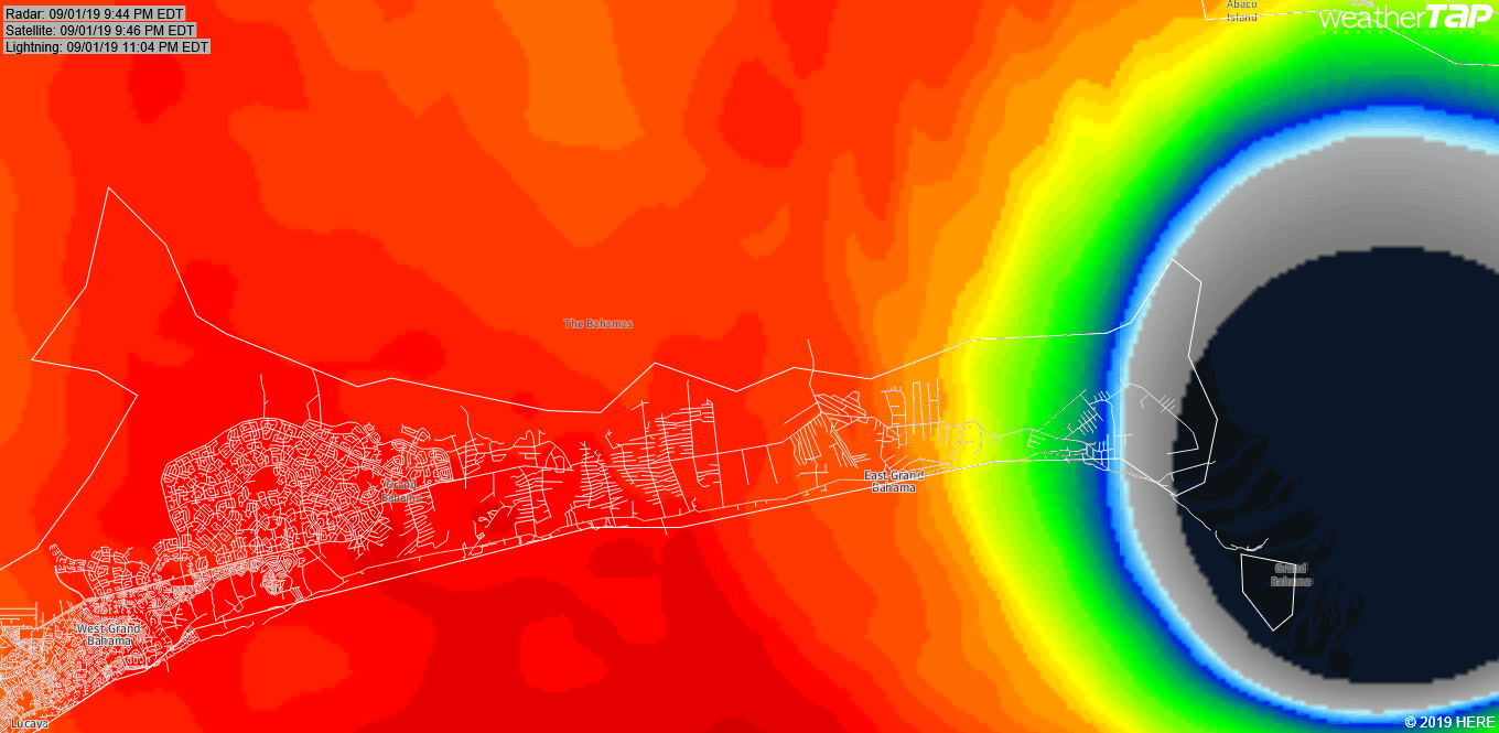
I have to say some of the destruction I'm seeing in the early imagery is about as bad as I've ever seen. The frightening thing is this is footage from the first half of the storm. To think that so many structures are in this kind of weakened state before the backside hits is sobering. And keep in mind this will be a backside that was slowing as it's coming through.
Imagery in the next few days will be nuclear....
-
DoctorMu

- Posts: 7925
- Joined: Sun Jun 28, 2015 11:58 am
- Location: College Station
- Contact:
Indeed, the eyewall and bads become farther from the center. Florida remains in grave danger.srainhoutx wrote: ↑Sun Sep 01, 2019 5:00 pm Tricky 12 to 24 hours ahead as Dorian under goes a eyewall replacement cycle. Typically the wind field expands and the cyclone may grow larger. With Dorian just 160 miles from the Florida Coast and the Gulf Stream ahead, I'm not sure all is clear for those along the East Coast of Florida.
-
Scott747
- Posts: 1647
- Joined: Tue Feb 23, 2010 9:56 am
- Location: Freeport/Surfside Beach
- Contact:
And for those wondering...
Josh was in an elevated part of the island and should have been safe from the surge. Winds at that speed however are a different ballgame but I think he will be fine.
I do have concerns for a fellow chaser (Jim Edds) that was on elbow cay directly to the e of Josh. Good news is that I've started seeing some reports coming from that area.
-
Ptarmigan
- Statistical Specialist
- Posts: 4505
- Joined: Wed Feb 03, 2010 7:20 pm
- Contact:

WSW motion with Dorian.
-
davidiowx
- Posts: 1190
- Joined: Thu Jan 23, 2014 2:39 pm
- Location: Richmond, TX
- Contact:
Amazing picture srain. I’ve seen some images out of Abacos and that’s just heartbreaking. Prayers for everyone that’s already been affected and everyone else in this historically strong storms path.
Having said that, what a beautiful, scary and humbling presentation by Mother Nature.
Having said that, what a beautiful, scary and humbling presentation by Mother Nature.
-
unome
- Posts: 3062
- Joined: Fri Feb 12, 2010 6:11 pm
thank you for that post, Scott !Scott747 wrote: ↑Sun Sep 01, 2019 8:00 pm And for those wondering...
Josh was in an elevated part of the island and should have been safe from the surge. Winds at that speed however are a different ballgame but I think he will be fine.
I do have concerns for a fellow chaser (Jim Edds) that was on elbow cay directly to the e of Josh. Good news is that I've started seeing some reports coming from that area.
-
Kingwood36
- Posts: 1592
- Joined: Sat Dec 29, 2018 10:29 am
- Location: Freeport
- Contact:
A little off topic but i hope wxman57 is eating some crow..ive been follwing him on 2k for a while before dorian became the beast he is now..i find wxman57 a bit cocky and arrogant at times and he was constantly saying dorian would be nothing blah blah..even when ppl would post stuff saying it "could" become something he would shut them down if his word is the gospel.just goes to show he isnt always right as he would want people to believe. Rant over
-
unome
- Posts: 3062
- Joined: Fri Feb 12, 2010 6:11 pm
-
Cpv17
- Posts: 7036
- Joined: Fri Aug 31, 2018 1:58 pm
- Location: El Campo/Wharton
- Contact:
Yeah I remember him saying when Dorian was just a wave that it would get killed off in the Caribbean.Kingwood36 wrote: ↑Sun Sep 01, 2019 8:33 pm A little off topic but i hope wxman57 is eating some crow..ive been follwing him on 2k for a while before dorian became the beast he is now..i find wxman57 a bit cocky and arrogant at times and he was constantly saying dorian would be nothing blah blah..even when ppl would post stuff saying it "could" become something he would shut them down if his word is the gospel.just goes to show he isnt always right as he would want people to believe. Rant over
-
Ptarmigan
- Statistical Specialist
- Posts: 4505
- Joined: Wed Feb 03, 2010 7:20 pm
- Contact:
Settlement Point, GBI, Bahamas
https://www.ndbc.noaa.gov/station_page. ... tion=spgf1
Pressure is dropping west of Freeport.
https://www.ndbc.noaa.gov/station_page. ... tion=spgf1
Pressure is dropping west of Freeport.
-
DoctorMu
- Posts: 7925
- Joined: Sun Jun 28, 2015 11:58 am
- Location: College Station
- Contact:
UKmet predicted the WSW jog..
We're seeing a potentially expanding windfield as well.
https://twitter.com/SteveWAFB/status/11 ... 95296?s=20
-
DoctorMu
- Posts: 7925
- Joined: Sun Jun 28, 2015 11:58 am
- Location: College Station
- Contact:
-
Andrew
- Site Admin
- Posts: 3508
- Joined: Wed Feb 03, 2010 9:46 pm
- Location: North-West Houston
- Contact:
Based on radar and satellite I still see a 5-6mph average movement over the last couple of hours. Now it is time to watch how far west this gets and how much weakening occurs.
For Your Infinite Source For All Things Weather Visit Our Facebook
-
Ptarmigan
- Statistical Specialist
- Posts: 4505
- Joined: Wed Feb 03, 2010 7:20 pm
- Contact:
It is going to be a very long night.
-
srainhoutx
- Site Admin
- Posts: 19700
- Joined: Tue Feb 02, 2010 2:32 pm
- Location: Maggie Valley, NC
- Contact:
Just a little Tropical Activity to monitor this Labor Day. Some rain for S Texas and Mexico regarding the Central Gulf disturbance.
- Attachments
-
Carla/Alicia/Jerry(In The Eye)/Michelle/Charley/Ivan/Dennis/Katrina/Rita/Wilma/Humberto/Ike/Harvey
Member: National Weather Association
Facebook.com/Weather Infinity
Twitter @WeatherInfinity
Member: National Weather Association
Facebook.com/Weather Infinity
Twitter @WeatherInfinity
-
unome
- Posts: 3062
- Joined: Fri Feb 12, 2010 6:11 pm
-
- Information
-
Who is online
Users browsing this forum: Bing [Bot], Google [Bot], Hou68, tireman4 and 20 guests