Hurricane Alex. 40 Miles NNE of La Pesca. 100 MPH/948MB

Tropical Weather Discussions and Analysis
Scott747
Posts: 1489
Joined: Tue Feb 23, 2010 9:56 am
Location: Freeport/Surfside Beach
Contact:

Andrew wrote:
Scott747 wrote:
Andrew wrote:Reports are coming in that the cone moved east.
N a bit up the coast...
Haha more or less what I meant. What I still don't understand is why Mexico has a hurricane warning so far south. I wonder if they believe it will go farther south then NHC believes.
Depending on the movement of Alex hurricane force winds could still be generated along those areas, even S of the eventual landfall point.

Also the watches/warnings are issued by the Mexican government and not directly by the NHC.
Andrew
Site Admin
Site Admin
Posts: 3446
Joined: Wed Feb 03, 2010 9:46 pm
Location: North-West Houston
Contact:

Scott747 wrote:
Andrew wrote:
Scott747 wrote:Reports are coming in that the cone moved east.
N a bit up the coast...
Haha more or less what I meant. What I still don't understand is why Mexico has a hurricane warning so far south. I wonder if they believe it will go farther south then NHC believes.
Depending on the movement of Alex hurricane force winds could still be generated along those areas, even S of the eventual landfall point.

Also the watches/warnings are issued by the Mexican government and not directly by the NHC.[/quote]

Yes I know Mexico issues the warnings but overall even if it went in west it would be on the drier side... Hmm just something interesting I saw.
For Your Infinite Source For All Things Weather Visit Our Facebook
Stormrider
Posts: 109
Joined: Wed Feb 03, 2010 11:50 pm
Contact:

Alex isn't reading the models. Sounds like a "bears watch" to me.

Another coffee drinking night. ;)
User avatar
Ptarmigan
Statistical Specialist
Posts: 4052
Joined: Wed Feb 03, 2010 7:20 pm
Contact:

The central pressure for Alex is quite low. The last time I saw something like this was with Wilma. Alex's circulation is quite large.

The satellite presentation kinda reminds me of Wilma. Do I expect Alex to be like Wilma. No.
Last edited by Ptarmigan on Mon Jun 28, 2010 10:26 pm, edited 1 time in total.
Scott747
Posts: 1489
Joined: Tue Feb 23, 2010 9:56 am
Location: Freeport/Surfside Beach
Contact:

biggerbyte wrote:It's because the thinking among many pros is that Mexico is the target. Some get hung up on models and can't see what is right in front of their eyes..


If I'm being honest. No offense to anyone.
You constantly put down the use of modeling to generate a forecast. It's only another tool that the NHC uses and they constantly blend them together with other real time data to try and make the best forecast available.

Let me ask you this.

Would you rather them discontinue the use of all models and have a seven day cone that covers about 1k miles?
User avatar
Mr. T
Posts: 992
Joined: Wed Feb 03, 2010 4:22 pm
Location: Kingwood
Contact:

As Alex continues its northward trek tonight, it'll be interesting to see when exactly it begins its bend westward
biggerbyte
Posts: 1142
Joined: Thu Feb 04, 2010 12:15 am
Location: Porter, Texas. (Montgomery County)
Contact:

Mr. T wrote:As Alex continues its northward trek tonight, it'll be interesting to see when exactly it begins its bend westward
Ditto! How far north will he go.. I sure would hate to see a major hurricane come in across Galveston from the east.
User avatar
desiredwxgd
Posts: 125
Joined: Wed Feb 03, 2010 6:30 pm
Location: TX/LA/Southern New England
Contact:

Scott747 wrote:
biggerbyte wrote:It's because the thinking among many pros is that Mexico is the target. Some get hung up on models and can't see what is right in front of their eyes..


If I'm being honest. No offense to anyone.
You constantly put down the use of modeling to generate a forecast. It's only another tool that the NHC uses and they constantly blend them together with other real time data to try and make the best forecast available.

Let me ask you this.

Would you rather them discontinue the use of all models and have a seven day cone that covers about 1k miles?
Play nice everyone. One shouldn't get to hung up on models just as we always say don't focus on the center of the "cone". Models are a great visual aid for the every "day-to-day" person. Models are only as good as the person who developed them and as good as the person who programs the info. And the most important thing to remember is that the weather around you, me, us, and around a storm is a constant state of change. Like I always say, “the only thing about weather that is predictable is its unpredictability”.
JMS
SR. ENSC.
Andrew
Site Admin
Site Admin
Posts: 3446
Joined: Wed Feb 03, 2010 9:46 pm
Location: North-West Houston
Contact:

biggerbyte wrote:
Mr. T wrote:As Alex continues its northward trek tonight, it'll be interesting to see when exactly it begins its bend westward
Ditto! How far north will he go.. I sure would hate to see a major hurricane come in across Galveston from the east.
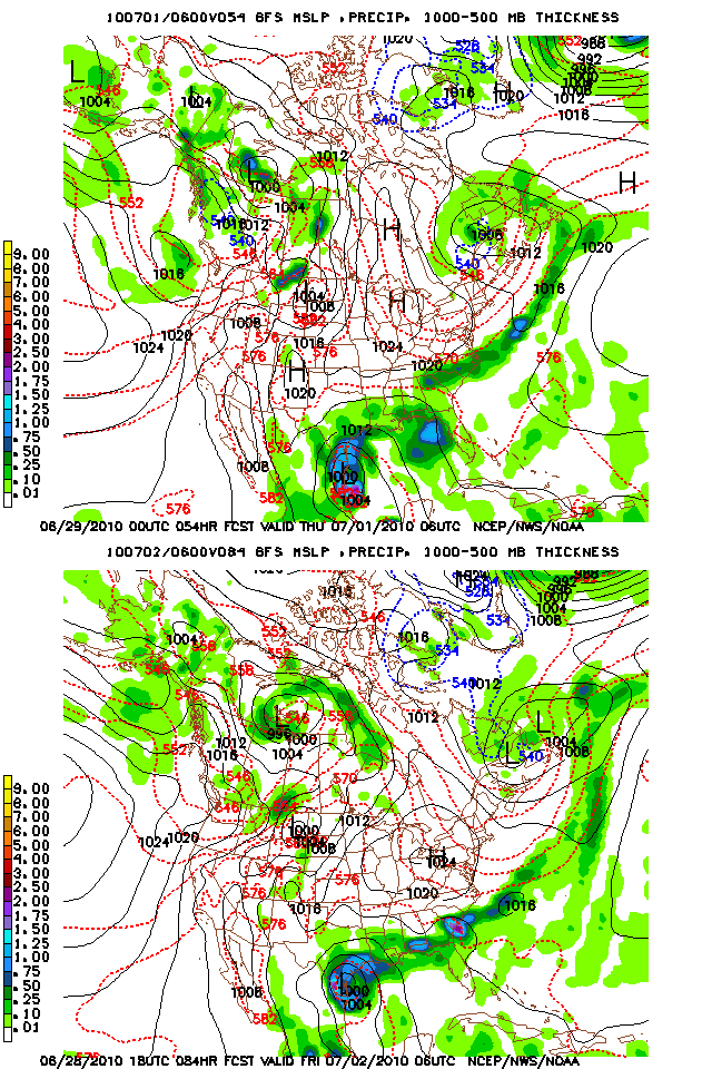
Operational gfs has it run north for 6 more hours and then take a 90 degree turn to the west.
For Your Infinite Source For All Things Weather Visit Our Facebook
biggerbyte
Posts: 1142
Joined: Thu Feb 04, 2010 12:15 am
Location: Porter, Texas. (Montgomery County)
Contact:

Scott747 wrote:
biggerbyte wrote:It's because the thinking among many pros is that Mexico is the target. Some get hung up on models and can't see what is right in front of their eyes..


If I'm being honest. No offense to anyone.
You constantly put down the use of modeling to generate a forecast. It's only another tool that the NHC uses and they constantly blend them together with other real time data to try and make the best forecast available.

Let me ask you this.

Would you rather them discontinue the use of all models and have a seven day cone that covers about 1k miles?
lol

Scott, I said nothing about the NHC, nor any person in particular. My statements refer to fanatics who do nothing but read models and rely on them exclusively to forecast. They see nothing else, even when it is obvious that the models are wrong. These people are out there, and they pose a danger towards the safety of the general public.


It is what it is. Now this is twice that you have poked at me today. I keep asking myself why you keep missing the obvious in
my posts... <<<<SMACK>>>>

Let's move on, shall we? At the very least, it is an opinion. :)

BB
Andrew
Site Admin
Site Admin
Posts: 3446
Joined: Wed Feb 03, 2010 9:46 pm
Location: North-West Houston
Contact:

Parallel GFS starts out with a NW run from the beginning

Image
For Your Infinite Source For All Things Weather Visit Our Facebook
User avatar
Mr. T
Posts: 992
Joined: Wed Feb 03, 2010 4:22 pm
Location: Kingwood
Contact:

Both the parallel GFS and OP GFS are going to be south of the previous landfall.

Looks like the OP GFS may be going into Mexico, or the TX/MX border
Scott747
Posts: 1489
Joined: Tue Feb 23, 2010 9:56 am
Location: Freeport/Surfside Beach
Contact:

biggerbyte wrote:
Scott747 wrote:
biggerbyte wrote:It's because the thinking among many pros is that Mexico is the target. Some get hung up on models and can't see what is right in front of their eyes..


If I'm being honest. No offense to anyone.
You constantly put down the use of modeling to generate a forecast. It's only another tool that the NHC uses and they constantly blend them together with other real time data to try and make the best forecast available.

Let me ask you this.

Would you rather them discontinue the use of all models and have a seven day cone that covers about 1k miles?
lol

Scott, I said nothing about the NHC, nor any person in particular. My statements refer to fanatics who do nothing but read models and rely on them exclusively to forecast. They see nothing else, even when it is obvious that the models are wrong. These people are out there, and they pose a danger towards the safety of the general public.


It is what it is. Now this is twice that you have poked at me today. I keep asking myself why you keep missing the obvious in
my posts... <<<<SMACK>>>>

Let's move on, shall we? At the very least, it is an opinion. :)

BB
It was easy to assume since your comment was right after Andrew musing why the forecast track was so far S. ;)

Agreed. Time to move on.
Andrew
Site Admin
Site Admin
Posts: 3446
Joined: Wed Feb 03, 2010 9:46 pm
Location: North-West Houston
Contact:

At this point in time I look at the models and I think what are the chances this will actually happen? At this point I don't know what to think. Operational seems to unreasonable to have that quick of a turn west. Parallel has it starting out on a NW track and is more reasonable (if it happens).
For Your Infinite Source For All Things Weather Visit Our Facebook
User avatar
Mr. T
Posts: 992
Joined: Wed Feb 03, 2010 4:22 pm
Location: Kingwood
Contact:

Big shift south on this run... Mexico he goes
sleetstorm
Posts: 651
Joined: Thu Feb 04, 2010 12:33 pm
Contact:

Tropical showers and thundestorms have nearly beleaguered Tropical Storm Alex's center of circulation.
User avatar
Mr. T
Posts: 992
Joined: Wed Feb 03, 2010 4:22 pm
Location: Kingwood
Contact:

0z landfall point vs. 18z landfall point:

Image
User avatar
Mr. T
Posts: 992
Joined: Wed Feb 03, 2010 4:22 pm
Location: Kingwood
Contact:

And, this is with the "extra data" inserted into the runs tonight. 0z parallel run is very similar

Methinks the odds of a Mexcian landfall just went way up

I think it is important to note that even if Alex were to make landfall so far to the south, we can still expect heavy rains around SE TX this upcoming week as an coastal trough situation sets up on the northern side of Alex's broad circulation. Flooding will definitely become a concern.
vci_guy2003
Posts: 203
Joined: Mon Jun 28, 2010 4:04 am
Contact:

Have all the models shifted south? Any northern outliers?
Snowman
Posts: 191
Joined: Sun Jun 27, 2010 11:25 pm
Location: Mountain View, CA
Contact:

yea we will see once this storm stops moving NORTH....
Post Reply
  • Information
  • Who is online

    Users browsing this forum: No registered users and 0 guests