Of the models that are hinting at a more westwardly movement in a few days resulting in landfall close to the border, what if anything do they indicate about a post-landfall track? I have heard some concerns expressed about potentially significant flooding from this system in the Houston area, even if the initial landfall were to take place closer to Brownsville... Thanks as always for everyone's input and guidance. This board is by far the most informative source for weather news in our region.
Scott747 wrote:18z para GFS has it just off the coast below the border at hr 96. Hints at a westward heading.
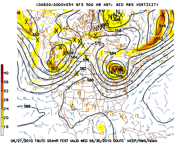
Very similar to the 6z run, showing a TX/MX border landfall. A little faster, though...
Correct. Given that the parallel has stayed consistent along with the operational coming back down the coast somewhat we may have seen a end to the n trend of the models.
Paul wrote:while we wait for the new model runs....wasnt Claudette coming up from the BOC and we kept thinking it should turn around CC but ended up around Matagorda? I dont remember things to well...
Paul, I seem to remember the same thing about Claudette. I have a better memory of Humberto, where the anticipated landfall shifted from Brownsville to Galveston in the course of a day. By the time it made landfall at Beaumont/Port Arthur, it was a minimal Cat 1.
I remember Claudette in 2003. I remember it forcasted to hit in Mexico to South Texas. It ended up in Matagorda Bay.
txsnowmaker wrote:Of the models that are hinting at a more westwardly movement in a few days resulting in landfall close to the border, what if anything do they indicate about a post-landfall track? I have heard some concerns expressed about potentially significant flooding from this system in the Houston area, even if the initial landfall were to take place closer to Brownsville... Thanks as always for everyone's input and guidance. This board is by far the most informative source for weather news in our region.
That is a great question. QPF forecast issued earlier today from the HPC was showing an area of 3-5 inches possible inland in SE TX. Of course higher totals along coastal Counties. Needless to say we will need to watch this part of the forecast carefully over the next couple of days. Many will remember TS Erin in 2007 and the amount of heavy rainfall on the SE side of town as it went inland just N of Port Aransas.
Carla/Alicia/Jerry(In The Eye)/Michelle/Charley/Ivan/Dennis/Katrina/Rita/Wilma/Humberto/Ike/Harvey
Member: National Weather Association
Facebook.com/Weather Infinity
Twitter @WeatherInfinity
I am not sure if it was Dolly or Erin but the first 3 or 4 streets in my neighborhood had serious water damage from the storm that parked over us for what seemed like forever during the afternoon. I know school had not begun yet I just don't remember which storm it was...
Scott747 wrote:18z para GFS has it just off the coast below the border at hr 96. Hints at a westward heading.
Very similar to the 6z run, showing a TX/MX border landfall. A little faster, though...
Correct. Given that the parallel has stayed consistent along with the operational coming back down the coast somewhat we may have seen a end to the n trend of the models.
I have been a EURO hugger for some time....after reading this you have to weigh in the other models now....no choice...
read what Stacey Stewart said about it in the 09Z discussion.
As far as the Euro is concerned...one only has to read my posts to understand that I am as big a EURO pimp as the next guy...but what none of us EURO pimps want to seem to talk about is this FACT: The EURO runs have consistently moved the 500 mb feature inland but maintained a sfc feature near the coast. The 12Z run moves the 500Mb low inland south of BRO but keeps the sfc low right at the coast for 4 days...
And that just aint right. Something is NOT right with what it is seeing.


