

Hurricane Alex. 40 Miles NNE of La Pesca. 100 MPH/948MB
-
srainhoutx

- Site Admin

- Posts: 19700
- Joined: Tue Feb 02, 2010 2:32 pm
- Location: Maggie Valley, NC
- Contact:
Still looking interesting just SE of Jamaica this morning. We shall see what today brings.
Carla/Alicia/Jerry(In The Eye)/Michelle/Charley/Ivan/Dennis/Katrina/Rita/Wilma/Humberto/Ike/Harvey
Member: National Weather Association
Facebook.com/Weather Infinity
Twitter @WeatherInfinity
Member: National Weather Association
Facebook.com/Weather Infinity
Twitter @WeatherInfinity
-
wxman57

- Global Moderator

- Posts: 2621
- Joined: Thu Feb 04, 2010 5:34 am
- Location: Southwest Houston (Westbury)
- Contact:
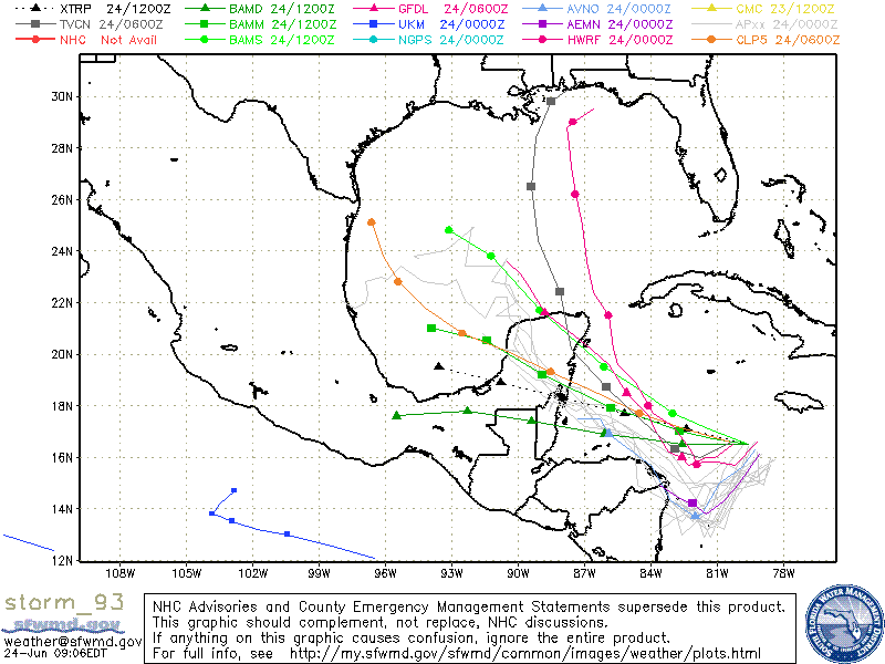
I wouldn't watch where the models were initialized, I'd look SE of Jamaica. That's a 2nd wave coming in from the east. We tracked it from Africa. It's the one that looks like the development threat. I can see the wave that became 93L way out west along 84W now. It's not developing. Late last week, models were actually developing this 2nd wave when it reached the central Caribbean, not the forerunner. NHC will keep the 93L designation, though. No need to confuse everyone (I hope).
Of course, this means that I would pay little attention to where the models move 93L now, as they'll probably be adjusted well to the east later today or tomorrow.
Of course, this means that I would pay little attention to where the models move 93L now, as they'll probably be adjusted well to the east later today or tomorrow.
-
srainhoutx
- Site Admin
- Posts: 19700
- Joined: Tue Feb 02, 2010 2:32 pm
- Location: Maggie Valley, NC
- Contact:
That would explain the multiple low pressure centers we have seen from various model output over the past few days. Thanks for the update wxman57. We know you are busy. 
Carla/Alicia/Jerry(In The Eye)/Michelle/Charley/Ivan/Dennis/Katrina/Rita/Wilma/Humberto/Ike/Harvey
Member: National Weather Association
Facebook.com/Weather Infinity
Twitter @WeatherInfinity
Member: National Weather Association
Facebook.com/Weather Infinity
Twitter @WeatherInfinity
-
srainhoutx
- Site Admin
- Posts: 19700
- Joined: Tue Feb 02, 2010 2:32 pm
- Location: Maggie Valley, NC
- Contact:


Carla/Alicia/Jerry(In The Eye)/Michelle/Charley/Ivan/Dennis/Katrina/Rita/Wilma/Humberto/Ike/Harvey
Member: National Weather Association
Facebook.com/Weather Infinity
Twitter @WeatherInfinity
Member: National Weather Association
Facebook.com/Weather Infinity
Twitter @WeatherInfinity
-
Portastorm

- Posts: 800
- Joined: Wed Feb 03, 2010 3:04 pm
- Location: Southwest Austin/Oak Hill, TX
- Contact:
Wxman57, I am always grateful for your virtual dose of meteorological reality. After spending several days on our "local" forum here along with S2K ... and reading a gazillion predictions by amateurs ... you have this unique way of patting us on the shoulder, in a non condescending way, and saying "uh no ... you're not right. Here is the situation."
As for me and my house ... I will focus SE of Jamaica for any development!
As for me and my house ... I will focus SE of Jamaica for any development!
-
srainhoutx
- Site Admin
- Posts: 19700
- Joined: Tue Feb 02, 2010 2:32 pm
- Location: Maggie Valley, NC
- Contact:
Code: Select all
WHXX01 KWBC 241303
CHGHUR
TROPICAL CYCLONE GUIDANCE MESSAGE
NWS TPC/NATIONAL HURRICANE CENTER MIAMI FL
1303 UTC THU JUN 24 2010

DISCLAIMER...NUMERICAL MODELS ARE SUBJECT TO LARGE ERRORS.
PLEASE REFER TO NHC OFFICIAL FORECASTS FOR TROPICAL CYCLONE
AND SUBTROPICAL CYCLONE INFORMATION.

ATLANTIC OBJECTIVE AIDS FOR

DISTURBANCE INVEST (AL932010) 20100624 1200 UTC

...00 HRS... ...12 HRS... ...24 HRS. .. ...36 HRS...
100624 1200 100625 0000 100625 1200 100626 0000

LAT LON LAT LON LAT LON LAT LON
BAMS 16.5N 79.6W 17.1N 81.4W 17.7N 83.0W 18.6N 84.5W
BAMD 16.5N 79.6W 16.5N 81.1W 16.5N 82.6W 16.7N 84.3W
BAMM 16.5N 79.6W 16.7N 81.2W 17.0N 82.7W 17.5N 84.2W
LBAR 16.5N 79.6W 16.9N 81.4W 17.7N 83.5W 18.8N 85.8W
SHIP 25KTS 29KTS 36KTS 45KTS
DSHP 25KTS 29KTS 36KTS 45KTS

...48 HRS... ...72 HRS... ...96 HRS. .. ..120 HRS...
100626 1200 100627 1200 100628 1200 100629 1200

LAT LON LAT LON LAT LON LAT LON
BAMS 19.5N 86.1W 21.7N 89.0W 23.8N 91.2W 24.8N 93.1W
BAMD 16.9N 86.1W 17.4N 89.4W 17.8N 92.3W 17.6N 95.5W
BAMM 17.9N 85.8W 19.2N 88.9W 20.5N 91.4W 21.0N 93.9W
LBAR 20.0N 88.0W 22.6N 91.5W 25.6N 93.1W 28.1N 94.1W
SHIP 54KTS 70KTS 80KTS 84KTS
DSHP 54KTS 41KTS 37KTS 40KTS

...INITIAL CONDITIONS...
LATCUR = 16.5N LONCUR = 79.6W DIRCUR = 285DEG SPDCUR = 8KT
LATM12 = 16.2N LONM12 = 78.2W DIRM12 = 281DEG SPDM12 = 5KT
LATM24 = 15.9N LONM24 = 76.8W
WNDCUR = 25KT RMAXWD = 75NM WNDM12 = 25KT
CENPRS = 1008MB OUTPRS = 1011MB OUTRAD = 180NM SDEPTH = S
RD34NE = 0NM RD34SE = 0NM RD34SW = 0NM RD34NW = 0NM
Carla/Alicia/Jerry(In The Eye)/Michelle/Charley/Ivan/Dennis/Katrina/Rita/Wilma/Humberto/Ike/Harvey
Member: National Weather Association
Facebook.com/Weather Infinity
Twitter @WeatherInfinity
Member: National Weather Association
Facebook.com/Weather Infinity
Twitter @WeatherInfinity
-
srainhoutx
- Site Admin
- Posts: 19700
- Joined: Tue Feb 02, 2010 2:32 pm
- Location: Maggie Valley, NC
- Contact:
HPC thoughts this morning...
...GULF OF MEXICO...
THE BEST CLUSTERING OF MODEL/ENSEMBLE SOLNS HAS ADJUSTED SOUTHWEST
FROM THIS TIME YESTERDAY WITH THE TRACK OF TROPICAL LOW PRESSURE
AREA FORECAST TO REACH THE WESTERN HALF OF THE GULF OF MEXICO.
THE 00Z CANADIAN IS NORTHEAST OF NEARLY ALL THE 00Z MULTI-MODEL
ENSEMBLE GUIDANCE AND COULD NOT BE USED NEAR THE GULF COAST. AS A
SURPRISE...THE 06Z GFS PARALLEL STUBBORNLY RECURVES THIS SYSTEM TO
THE NORTHEAST GULF COAST. A BLEND OF CLIMATOLOGY FOR LATE
JUNE/EARLY JULY AND THE ENSEMBLE GUIDANCE /WHICH HAS TRENDED AWAY
FROM THIS IDEA/ HAS LOWERED THE CHANCES FOR THIS OCCURRENCE TO
AROUND 15 PERCENT...SO THIS SOLUTION IS CONSIDERED A LOW
PROBABILITY ALTERNATIVE SCENARIO. BY THE LATTER HALF OF THE
PERIOD A COMPROMISE WAS MADE BETWEEN THE LAST COUPLE SHIFTS OF
PRESSURES IN REGARDS TO THIS SYSTEMS TRACK WHICH REMAINS A BIT
SOUTHWEST OF THE COORDINATED 23/16Z HPC/NHC POINTS YET CLOSE TO
THE 22/16Z COORDINATED POINTS AND BRINGS THE SYSTEM TOWARDS THE
US/MEXICAN BORDER LATE NEXT WEEK. EITHER WAY...RAINFALL IS
EXPECTED TO BE FOCUSED TO THE NORTHEAST OF THIS SYSTEM NEAR THE
FRONTAL ZONE DRAPED NEAR THE NORTHERN GULF COAST.
Carla/Alicia/Jerry(In The Eye)/Michelle/Charley/Ivan/Dennis/Katrina/Rita/Wilma/Humberto/Ike/Harvey
Member: National Weather Association
Facebook.com/Weather Infinity
Twitter @WeatherInfinity
Member: National Weather Association
Facebook.com/Weather Infinity
Twitter @WeatherInfinity

-
srainhoutx
- Site Admin
- Posts: 19700
- Joined: Tue Feb 02, 2010 2:32 pm
- Location: Maggie Valley, NC
- Contact:
CARCAH has tasked the next two missions. Obviously there is still interest in this disturbance and that is likely to not change in the days ahead.
000
NOUS42 KNHC 241445
WEATHER RECONNAISSANCE FLIGHTS
CARCAH, NATIONAL HURRICANE CENTER, MIAMI, FL.
1045 AM EDT THU 24 JUNE 2010
SUBJECT: TROPICAL CYCLONE PLAN OF THE DAY (TCPOD)
VALID 25/1100Z TO 26/1100Z JUNE 2010
TCPOD NUMBER.....10-024
I. ATLANTIC REQUIREMENTS
1. SUSPECT AREA (WESTERN CARIBBEAN)
FLIGHT ONE - TEAL 70
A. 25/1800Z
B. AFXXX 01AAA INVEST
C. 25/1430Z
D. 17.5N 83.0W
E. 25/1730Z TO 25/2200Z
F. SFC TO 10,000 FT
FLIGHT TWO - TEAL 71
A. 26/0600Z
B. AFXXX 0201A CYCLONE
C. 26/0200Z
D. 18.0N 84.5W
E. 26/0500Z TO 26/0900Z
F. SFC TO 10,000 FT
2. SUCCEEDING DAY OUTLOOK: BEGIN 6-HRLY FIXES
AT 26/1800Z IF SYSTEM DEVELOPS.
3. REMARKS: TASKING FOR 24/1800Z AND 25/0600Z
CANCELED BY NHC AT 24/1135Z.
II. PACIFIC REQUIREMENTS
1. NEGATIVE RECONNAISSANCE REQUIREMENTS.
2. OUTLOOK FOR SUCCEEDING DAY.....NEGATIVE.
JWP
Carla/Alicia/Jerry(In The Eye)/Michelle/Charley/Ivan/Dennis/Katrina/Rita/Wilma/Humberto/Ike/Harvey
Member: National Weather Association
Facebook.com/Weather Infinity
Twitter @WeatherInfinity
Member: National Weather Association
Facebook.com/Weather Infinity
Twitter @WeatherInfinity
-
Hardcoreweather
TCFA ISSUED
WTNT21 KNGU 241500
SUBJ/TROPICAL CYCLONE FORMATION ALERT 241430Z JUN 10//
RMKS/1. FORMATION OF A TROPICAL CYCLONE IS POSSIBLE WITHIN 100NM
EITHER SIDE OF A LINE FROM 16.5N 79.6W TO 17.7N 83.8W WITHIN THE
NEXT 24 HOURS. AVAILABLE DATA DOES NOT JUSTIFY ISSUANCE OF NUMBERED
TROPICAL CYCLONE WARNINGS AT THIS TIME.
2. A LOW PRESSURE CENTER LOCATED NEAR 16.5N 79.6W IS CURRENTLY MOVING
WEST-NORTHWESTWARD AT APPROXIMATELY 10 KTS. AT 24/1200Z INFRARED
SATELLITE IMAGERY INDICATED AN AREA OF CONVECTION THAT HAS PERSISTED
FOR THE PAST 12 HOURS. THIS SYSTEM IS CURRENTLY MOVING INTO AN AREA OF
RELATIVELY LOWER WIND SHEAR, UPPER LEVEL ANTI-CYCLONIC OUTFLOW AND IS
TRACKING TOWARDS WARMER SEA SURFACE TEMPERATURES OF 83 TO 86 DEGREES
FAHRENHEIT, HELPING TO ENHANCE THE DEVELOPMENT OF THIS TROPICAL FEATURE.
3. THIS ALERT WILL BE REISSUED, UPGRADED TO A WARNING OR ALLOWED TO EXPIRE
BY 251500Z JUN 2010.//

-
srainhoutx
- Site Admin
- Posts: 19700
- Joined: Tue Feb 02, 2010 2:32 pm
- Location: Maggie Valley, NC
- Contact:


Carla/Alicia/Jerry(In The Eye)/Michelle/Charley/Ivan/Dennis/Katrina/Rita/Wilma/Humberto/Ike/Harvey
Member: National Weather Association
Facebook.com/Weather Infinity
Twitter @WeatherInfinity
Member: National Weather Association
Facebook.com/Weather Infinity
Twitter @WeatherInfinity
-
srainhoutx
- Site Admin
- Posts: 19700
- Joined: Tue Feb 02, 2010 2:32 pm
- Location: Maggie Valley, NC
- Contact:
 [/quote]
Carla/Alicia/Jerry(In The Eye)/Michelle/Charley/Ivan/Dennis/Katrina/Rita/Wilma/Humberto/Ike/Harvey
Member: National Weather Association
Facebook.com/Weather Infinity
Twitter @WeatherInfinity
Member: National Weather Association
Facebook.com/Weather Infinity
Twitter @WeatherInfinity
-
sleetstorm
- Posts: 651
- Joined: Thu Feb 04, 2010 12:33 pm
- Contact:
What is that large swirl of clouds x-number of miles east-northeast of Honduras and Guatmala?
-
srainhoutx
- Site Admin
- Posts: 19700
- Joined: Tue Feb 02, 2010 2:32 pm
- Location: Maggie Valley, NC
- Contact:
That is another wave behind 93L that the GFS is also sniffing out for possible development. We shall see.sleetstorm wrote:What is that large swirl of clouds x-number of miles east-northeast of Honduras and Guatmala?
Carla/Alicia/Jerry(In The Eye)/Michelle/Charley/Ivan/Dennis/Katrina/Rita/Wilma/Humberto/Ike/Harvey
Member: National Weather Association
Facebook.com/Weather Infinity
Twitter @WeatherInfinity
Member: National Weather Association
Facebook.com/Weather Infinity
Twitter @WeatherInfinity
-
srainhoutx
- Site Admin
- Posts: 19700
- Joined: Tue Feb 02, 2010 2:32 pm
- Location: Maggie Valley, NC
- Contact:
Code: Select all
WHXX01 KWBC 241743
CHGHUR
TROPICAL CYCLONE GUIDANCE MESSAGE
NWS TPC/NATIONAL HURRICANE CENTER MIAMI FL
1743 UTC THU JUN 24 2010

DISCLAIMER...NUMERICAL MODELS ARE SUBJECT TO LARGE ERRORS.
PLEASE REFER TO NHC OFFICIAL FORECASTS FOR TROPICAL CYCLONE
AND SUBTROPICAL CYCLONE INFORMATION.

ATLANTIC OBJECTIVE AIDS FOR

DISTURBANCE INVEST (AL932010) 20100624 1800 UTC

        ...00 HRS...   ...12 HRS...   ...24 HRS. ..   ...36 HRS...
        100624  1800   100625  0600   100625  1800   100626  0600

         LAT    LON     LAT    LON     LAT    LON     LAT    LON
BAMS    16.5N  81.5W   16.6N  83.2W   17.3N  84.5W   17.9N  85.9W
BAMD    16.5N  81.5W   16.3N  82.9W   16.4N  84.5W   16.6N  86.1W
BAMM    16.5N  81.5W   16.5N  83.0W   17.0N  84.4W   17.5N  85.7W
LBAR    16.5N  81.5W   16.8N  83.5W   17.5N  85.8W   18.6N  88.2W
SHIP        25KTS          27KTS          32KTS          40KTS
DSHP        25KTS          27KTS          32KTS          40KTS

        ...48 HRS...   ...72 HRS...   ...96 HRS. ..   ..120 HRS...
        100626  1800   100627  1800   100628  1800   100629  1800

         LAT    LON     LAT    LON     LAT    LON     LAT    LON
BAMS    19.1N  87.3W   21.8N  89.5W   24.4N  91.3W   25.5N  92.8W
BAMD    16.8N  87.8W   17.4N  90.8W   17.9N  93.6W   17.9N  97.2W
BAMM    18.2N  87.2W   20.0N  89.8W   21.7N  91.8W   22.5N  93.9W
LBAR    19.7N  90.6W   22.4N  94.1W   25.4N  95.8W   27.8N  96.7W
SHIP        50KTS          66KTS          73KTS          75KTS
DSHP        50KTS          30KTS          37KTS          39KTS

         ...INITIAL CONDITIONS...
LATCUR =  16.5N LONCUR =  81.5W DIRCUR = 280DEG SPDCUR =  10KT
LATM12 =  16.4N LONM12 =  79.3W DIRM12 = 278DEG SPDM12 =  11KT
LATM24 =  16.1N LONM24 =  77.7W
WNDCUR =   25KT RMAXWD =   75NM WNDM12 =   25KT
CENPRS = 1008MB OUTPRS = 1011MB OUTRAD =  180NM SDEPTH =   S
RD34NE =    0NM RD34SE =    0NM RD34SW =    0NM RD34NW =   0NM

Carla/Alicia/Jerry(In The Eye)/Michelle/Charley/Ivan/Dennis/Katrina/Rita/Wilma/Humberto/Ike/Harvey
Member: National Weather Association
Facebook.com/Weather Infinity
Twitter @WeatherInfinity
Member: National Weather Association
Facebook.com/Weather Infinity
Twitter @WeatherInfinity
-
Mr. T

- Posts: 992
- Joined: Wed Feb 03, 2010 4:22 pm
- Location: Kingwood
- Contact:
Man, the GFDL and HWRF are pure garbage with their track. If they keep developing 93L so quickly, they will continue to be way too far east and north with their tracks... A stronger storm moves more poleward, which is why these models have been to the right.
In order for the GFDL or HWRF to even come close to verifying, 93L would have to turn NW now... Just looking at visible satellite, the naked swirl of 93L continues its course westward.
When looking at the 12z Euro, it seems to have initialized the best, showing a westward course into the Yucatan, and then beginning to turn to the north once this system finally begins to get its act together in the GOM.
Speaking of which, the 12z Euro shows landfall north of Brownsville
-
Portastorm
- Posts: 800
- Joined: Wed Feb 03, 2010 3:04 pm
- Location: Southwest Austin/Oak Hill, TX
- Contact:
Isn't this the second run in a row of the Euro which depicts a near Brownsville landfall?Mr. T wrote:Man, the GFDL and HWRF are pure garbage with their track. If they keep developing 93L so quickly, they will continue to be way too far east and north with their tracks... A stronger storm moves more poleward, which is why these models have been to the right.
In order for the GFDL or HWRF to even come close to verifying, 93L would have to turn NW now... Just looking at visible satellite, the naked swirl of 93L continues its course westward.
When looking at the 12z Euro, it seems to have initialized the best, showing a westward course into the Yucatan, and then beginning to turn to the north once this system finally begins to get its act together in the GOM.
Speaking of which, the 12z Euro shows landfall north of Brownsville
-
Mr. T
- Posts: 992
- Joined: Wed Feb 03, 2010 4:22 pm
- Location: Kingwood
- Contact:
The Euro has really liked the idea for a S TX or N MX landfall, save for a few wobbles here and there. The main reason for this is likely the model's continued forecast for 93L to not have much development until it enters the GOM, allowing it to stay on a southerly course. From what we've seen of 93L the past few days and what it looks like right now, the Euro is probably right. For whatever reason, the tropical models seem to think the environment around 93L is a lot better than it actually is.Portastorm wrote: Isn't this the second run in a row of the Euro which depicts a near Brownsville landfall?
Last edited by Mr. T on Thu Jun 24, 2010 1:59 pm, edited 1 time in total.


