
August 2017: Looking Back at Harvey 5 Year Later
-
srainhoutx

- Site Admin

- Posts: 19700
- Joined: Tue Feb 02, 2010 2:32 pm
- Location: Maggie Valley, NC
- Contact:
NOAA G-IV will depart Tampa shortly. Here are their drop points all around the Gulf for the Mission.
- Attachments
-
- 08222017 GIV Harrvey untitled.png (60.15 KiB) Viewed 7680 times
Carla/Alicia/Jerry(In The Eye)/Michelle/Charley/Ivan/Dennis/Katrina/Rita/Wilma/Humberto/Ike/Harvey
Member: National Weather Association
Facebook.com/Weather Infinity
Twitter @WeatherInfinity
Member: National Weather Association
Facebook.com/Weather Infinity
Twitter @WeatherInfinity
-
brooksgarner

- Global Moderator

- Posts: 226
- Joined: Tue Jun 04, 2013 3:06 pm
- Location: Houston, TX
- Contact:
No center of circulation/closed-low, so no center to initialized model forecasts on. GOES-16 vis loop suggests it's centered over the northwest Yucatan Peninsula, south of Merida, Mexico... But it could easily re-center north of the Peninsula, or the TUTT low could inhibit development with wind shear, delaying any spin-up... or not. Time will tell, future-18z model runs aside.
Broadcast Met
http://BrooksGarner.com
http://twitter.com/BrooksWeather
http://BrooksGarner.com
http://twitter.com/BrooksWeather
- '17 Harvey
- '12 Sandy (P3 Orion)
- '91 Bob
- '85 Gloria
-
brooksgarner
- Global Moderator
- Posts: 226
- Joined: Tue Jun 04, 2013 3:06 pm
- Location: Houston, TX
- Contact:
Thanks Steve! Looks like NOAA-49 - Gonzo! - departs this evening around 00zsrainhoutx wrote:NOAA G-IV will depart Tampa shortly. Here are their drop points all around the Gulf for the Mission.
I. ATLANTIC REQUIREMENTS
1. REMNANTS OF TROPICAL DEPRESSION HARVEY
FLIGHT ONE -- NOAA 49 FLIGHT TWO -- TEAL 71
A. 23/0000Z A. 23/1200Z
B NOAA9 0609A HARVEY B. AFXXX 0709A HARVEY
C. 22/1730Z C. 23/0900Z
D. NA D. 20.0N 92.0W
E. NA E. 23/1130Z TO 23/1430Z
F. 41,000 TO 45,000 FT F. SFC TO 10,000 FT
Broadcast Met
http://BrooksGarner.com
http://twitter.com/BrooksWeather
http://BrooksGarner.com
http://twitter.com/BrooksWeather
- '17 Harvey
- '12 Sandy (P3 Orion)
- '91 Bob
- '85 Gloria
-
srainhoutx
- Site Admin
- Posts: 19700
- Joined: Tue Feb 02, 2010 2:32 pm
- Location: Maggie Valley, NC
- Contact:
Uh...this is Steve...brooksgarner wrote:Thanks Jeff!srainhoutx wrote:NOAA G-IV will depart Tampa shortly. Here are their drop points all around the Gulf for the Mission.
Carla/Alicia/Jerry(In The Eye)/Michelle/Charley/Ivan/Dennis/Katrina/Rita/Wilma/Humberto/Ike/Harvey
Member: National Weather Association
Facebook.com/Weather Infinity
Twitter @WeatherInfinity
Member: National Weather Association
Facebook.com/Weather Infinity
Twitter @WeatherInfinity
-
tireman4

- Global Moderator
- Posts: 7141
- Joined: Wed Feb 03, 2010 9:24 pm
- Location: Humble, Texas
- Contact:
His nickname is Jeff to his friends...srainhoutx wrote:Uh...this is Steve...brooksgarner wrote:Thanks Jeff!srainhoutx wrote:NOAA G-IV will depart Tampa shortly. Here are their drop points all around the Gulf for the Mission.
-
brooksgarner
- Global Moderator
- Posts: 226
- Joined: Tue Jun 04, 2013 3:06 pm
- Location: Houston, TX
- Contact:
Multi-tasking! Sorry, Mr. Ayers! -BGsrainhoutx wrote:Uh...this is Steve...brooksgarner wrote:Thanks Jeff!srainhoutx wrote:NOAA G-IV will depart Tampa shortly. Here are their drop points all around the Gulf for the Mission.
Broadcast Met
http://BrooksGarner.com
http://twitter.com/BrooksWeather
http://BrooksGarner.com
http://twitter.com/BrooksWeather
- '17 Harvey
- '12 Sandy (P3 Orion)
- '91 Bob
- '85 Gloria
-
srainhoutx
- Site Admin
- Posts: 19700
- Joined: Tue Feb 02, 2010 2:32 pm
- Location: Maggie Valley, NC
- Contact:
brooksgarner wrote:Thanks Steve! Looks like NOAA-49 - Gonzo! - departs this evening around 00zsrainhoutx wrote:NOAA G-IV will depart Tampa shortly. Here are their drop points all around the Gulf for the Mission.
I. ATLANTIC REQUIREMENTS
1. REMNANTS OF TROPICAL DEPRESSION HARVEY
FLIGHT ONE -- NOAA 49 FLIGHT TWO -- TEAL 71
A. 23/0000Z A. 23/1200Z
B NOAA9 0609A HARVEY B. AFXXX 0709A HARVEY
C. 22/1730Z C. 23/0900Z
D. NA D. 20.0N 92.0W
E. NA E. 23/1130Z TO 23/1430Z
F. 41,000 TO 45,000 FT F. SFC TO 10,000 FT
NOAA’s G-IV Hurricane Hunter Jet will fly around the remnants of Harvey
August 22, 2017 · by noaahrd
The G-IV jet is getting ready for a flight in the Gulf of Mexico. It will fly around the remnants of Harvey. The take off time is set for 1730 UTC (1:30PM ET) out of the Lakeland Linder Regional Airport in Lakeland, FL. The jet will also sample the mid- to upper-trough over the northern Gulf. Below is the flight track. The dots on the flight track denote the dropwindsonde launch locations.
https://noaahrd.wordpress.com/2017/08/2 ... of-harvey/
Carla/Alicia/Jerry(In The Eye)/Michelle/Charley/Ivan/Dennis/Katrina/Rita/Wilma/Humberto/Ike/Harvey
Member: National Weather Association
Facebook.com/Weather Infinity
Twitter @WeatherInfinity
Member: National Weather Association
Facebook.com/Weather Infinity
Twitter @WeatherInfinity
-
brooksgarner
- Global Moderator
- Posts: 226
- Joined: Tue Jun 04, 2013 3:06 pm
- Location: Houston, TX
- Contact:
Thanks! (I got to ride on that jet a number of years ago... "Gonzo", and was impressed at the vast instrumentation in that thing. Hard-edge computer racks and lots of science!) It flies high and fast.
Broadcast Met
http://BrooksGarner.com
http://twitter.com/BrooksWeather
http://BrooksGarner.com
http://twitter.com/BrooksWeather
- '17 Harvey
- '12 Sandy (P3 Orion)
- '91 Bob
- '85 Gloria
-
tireman4
- Global Moderator
- Posts: 7141
- Joined: Wed Feb 03, 2010 9:24 pm
- Location: Humble, Texas
- Contact:
000
FXUS64 KHGX 221501
AFDHGX
Area Forecast Discussion
National Weather Service Houston/Galveston TX
1001 AM CDT Tue Aug 22 2017
.UPDATE...
2 inch satellite derived pws surrounding Southeast Texas...with
the region still under the relatively drier 1.6 to 1.7 inch
air mass. Higher moisture residing over the Sabine River Valley
and into the extreme northwestern Gulf is slowly creeping
westward into our far southeastern CWA this morning. Radar shows
this as early day Gulf convection is firing off of Cameron Parish.
Today looking very similar to yesterday in the way the cumulus
field is developing...a slightly earlier start to the cloud deck
with highest rain chances (30%) focused along the nearshore waters
into the coastal and second tier counties. Mid to upper 90s will
equate to heat indices in the 100 to 106 F range this afternoon...
closer to 106 F along the coast where dew points will only mix
out into the middle 70s.
Monitoring the tropical wave over the northern Yucatan peninsula
that is forecast to be over the southern Bay of Campeche this
time tomorrow. Obviously...since the remnants of Harvey are a very
disorganized wave over land...current confidence is very low on
this system`s eventual track. Once this wave does get into the bay
and evolves into closed off low is when the deterministic models
will have a better fix (initiation point) to ultimately increase
confidence in subsequent model tracks. With that being said...now
is the time to review your hurricane plan and begin thinking
about how you will enact your plan in a few days if and when a
tropical cyclone does reach the Texas coastline. Stay tuned! 31
-
unome
- Posts: 3062
- Joined: Fri Feb 12, 2010 6:11 pm
http://www.nhc.noaa.gov/text/refresh/MI ... WDAT.shtml?
parts of it
...SPECIAL FEATURES...
A tropical wave extends from 14N89W to 24N88W moving NW at 10-15 kt. The remnant circulation of Harvey continues to be analyzed as a 1010 mb low along the wave axis near 19N89W with scattered moderate convection occurring from 19N-24N between 84W-89W. Widely scattered moderate convection is elsewhere from 16N-27N between 84W-92W. The low pressure area along the wave is forecast to emerge off the coast of the Yucatan peninsula tonight with environmental conditions favorable for development across the SW Gulf of Mexico through Thursday. Largest impacts at this point will be the expected rainfall and strong convection today across the Yucatan peninsula and adjacent coastal waters through this evening.
GULF OF MEXICO...
An upper level low is centered over the western Gulf near 27N92W and continues to support isolated showers and tstms occurring primarily N of 23N between 87W-96W. Some of the convection within the southeastern periphery of this area begins to fall under the influence of a tropical wave and the remnant low of Harvey mentioned in the Special Features section above. The northern extent of the wave extends along 89W with the 1010 mb low centered across the Yucatan peninsula near 19N89W. Scattered showers and tstms are occurring S of 27N between 85W-91W in association with the wave. Otherwise...ridging to the N remains anchored across the SE CONUS with a 1019 mb high centered across the Lower Mississippi River valley. Light to moderate easterly winds prevail mainly N of 22N. This overall synoptic pattern is expected to persist until tonight when the Special Features low pressure area emerges off the coast of the Yucatan peninsula and into the SW Gulf waters where environmental conditions are favorable for development of a tropical cyclone later this week.
-
srainhoutx
- Site Admin
- Posts: 19700
- Joined: Tue Feb 02, 2010 2:32 pm
- Location: Maggie Valley, NC
- Contact:
While we wait on the ECMWF to begin in about 30 minutes, let's take a look at features upstream over North America via Water Vapor Loop Imagery. In the Gulf S of Louisiana we see that TUTT low meandering its way toward the Upper Texas Coast and that trend should continue until tomorrow when it may begin to shear out/fill in a push the Upper Ridge back West which is currently situated near El Paso on the far Eastern edge of the Western Ridge periphery. Looking up in Canada, we can see the Trough digging SE toward the NE and Mid Atlantic Region. Across the Central/Southern Plains we notice that frontal boundary organizing that was firing storms over Eastern Kansas and Missouri, but are dissipating. The combination of all of these feature will plan an important role in exactly how all this situation will evolve. Typically a stalling frontal boundary with a weakness over the Western Gulf and a Tropical System spells trouble for the Texas and Louisiana Coast and inland location. Think back to Allison 2001, Remember the hours we watch Dr. Neil, David Paul and Mario Gomez? Also remember what happens when a weak Tropical Storm in a collapsed steering flow can do just with continuous heavy rainfall? Is it possible that type of situation can happen again? Certainly. Do we absolutely know with any certainty as of 12:48 PM CDT that it will happen again? No, we don't. We see the trends and know that the possibilities are increasing that somewhere along the Texas Coast may have issues and inland flooding may end up being the biggest news maker of this event.
- Attachments
-
Carla/Alicia/Jerry(In The Eye)/Michelle/Charley/Ivan/Dennis/Katrina/Rita/Wilma/Humberto/Ike/Harvey
Member: National Weather Association
Facebook.com/Weather Infinity
Twitter @WeatherInfinity
Member: National Weather Association
Facebook.com/Weather Infinity
Twitter @WeatherInfinity
-
tireman4
- Global Moderator
- Posts: 7141
- Joined: Wed Feb 03, 2010 9:24 pm
- Location: Humble, Texas
- Contact:
Models...
-
unome
- Posts: 3062
- Joined: Fri Feb 12, 2010 6:11 pm
recon http://hurricanecity.com/recon/
Jim hosts tropicalatlantic.com's to help reduce the load on Chris' site - the Cesium mapper is awesome, with no plugin required: http://hurricanecity.com/recon/recon.cg ... ing=cesium
Jim hosts tropicalatlantic.com's to help reduce the load on Chris' site - the Cesium mapper is awesome, with no plugin required: http://hurricanecity.com/recon/recon.cg ... ing=cesium
-
tireman4
- Global Moderator
- Posts: 7141
- Joined: Wed Feb 03, 2010 9:24 pm
- Location: Humble, Texas
- Contact:
2 PM TWO up to 90%/100%
Satellite images indicate that an area of low pressure over
the Yucatan Peninsula, associated with the remnants of Harvey, has
become better defined during the day. Environmental conditions are
conducive for development when the system moves over the Bay of
Campeche tonight, and a tropical depression is expected to form over
the southwestern Gulf of Mexico on Wednesday or Thursday, and move
in the general direction of the Texas coast on Friday. Interests in
northeastern Mexico and along the Texas coast should monitor the
progress of this system, as it could produce storm surge and
tropical storm or hurricane force winds along portions of the Texas
coast, and very heavy rainfall across portions of central and
eastern Texas from Friday through the weekend. Please refer to
products from your local National Weather Service office for more
information on this system.
* Formation chance through 48 hours...high...90 percent.
* Formation chance through 5 days...high...near 100 percent.
-
Scott747
- Posts: 1648
- Joined: Tue Feb 23, 2010 9:56 am
- Location: Freeport/Surfside Beach
- Contact:
Good news is that the 12z models have backed off on intensity. Bad news is that the potential for a major flooding event remains.
Also I think the 18z guidance will be a bit off if the coc is developing further n on the yucatan.
Also I think the 18z guidance will be a bit off if the coc is developing further n on the yucatan.
-
unome
- Posts: 3062
- Joined: Fri Feb 12, 2010 6:11 pm
NHC good at updating via Twitter https://twitter.com/NHC_Atlantic
For more information on the remnants of #Harvey, follow @NWSBrownsville, @NWSCorpus, @NWSHouston, @NWSLakeCharles, and @NWSWPC
Key Messages on the remnants of #Harvey, which could bring multiple hazards to portions of the Texas coast as soon as Friday.
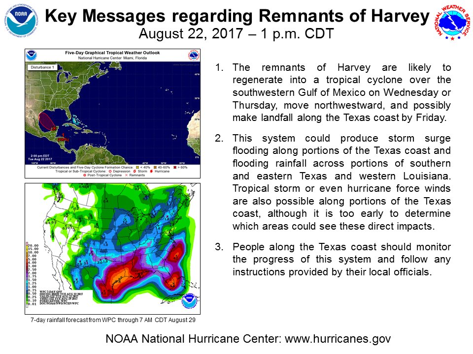
For more information on the remnants of #Harvey, follow @NWSBrownsville, @NWSCorpus, @NWSHouston, @NWSLakeCharles, and @NWSWPC
Key Messages on the remnants of #Harvey, which could bring multiple hazards to portions of the Texas coast as soon as Friday.
-
srainhoutx
- Site Admin
- Posts: 19700
- Joined: Tue Feb 02, 2010 2:32 pm
- Location: Maggie Valley, NC
- Contact:
ECMWF much weaker. Landfall looks to be near S Padre Island/King Ranch area of S Texas.
- Attachments
-
Carla/Alicia/Jerry(In The Eye)/Michelle/Charley/Ivan/Dennis/Katrina/Rita/Wilma/Humberto/Ike/Harvey
Member: National Weather Association
Facebook.com/Weather Infinity
Twitter @WeatherInfinity
Member: National Weather Association
Facebook.com/Weather Infinity
Twitter @WeatherInfinity
-
TexasBreeze
- Posts: 1026
- Joined: Sun Sep 26, 2010 4:46 pm
- Location: NW Houston, TX
- Contact:
Goes inland south TX then goes back se into the Gulf again.
-
Scott747
- Posts: 1648
- Joined: Tue Feb 23, 2010 9:56 am
- Location: Freeport/Surfside Beach
- Contact:
12z. Euro is a rain event for the ages for Texas. Still in our vicinity all the way into next Wednesday.
-
stormlover
- Posts: 439
- Joined: Wed Dec 04, 2013 10:21 am
- Location: Lumberton TX
- Contact:
Yeah would be a really bad flood event!!! That's what basically every model shows