
IF this makes it to the GOM, it will be like a runaway train with plenty of track, and plenty of fuel. What is there to stop it?
It may never develop, but it will not be because conditions are not right.
Also, I would take all of the models with a grain of salt, whether it be direction, or intensity/development.
I urge everyone to not assume anything with 93l until it has COMPLETELY taken it's last breath. With the Gulf primed like it is, it would be ultra foolish to do otherwise.
Hurricane Alex. 40 Miles NNE of La Pesca. 100 MPH/948MB
-
biggerbyte
- Posts: 1437
- Joined: Thu Feb 04, 2010 12:15 am
- Location: Porter, Texas. (Montgomery County)
- Contact:
-
Andrew
- Site Admin

- Posts: 3508
- Joined: Wed Feb 03, 2010 9:46 pm
- Location: North-West Houston
- Contact:
A 10% increase... The storm is moving into a better area for development
TWOAT
TROPICAL WEATHER OUTLOOK
NWS TPC/NATIONAL HURRICANE CENTER MIAMI FL
200 PM EDT WED JUN 23 2010
FOR THE NORTH ATLANTIC...CARIBBEAN SEA AND THE GULF OF MEXICO...
AN ELONGATED AREA OF DISTURBED WEATHER EXTENDS FROM EASTERN CUBA AND
JAMAICA EASTWARD ACROSS HISPANIOLA TO PUERTO RICO AND THE ADJACENT
WATERS OF THE NORTHERN CARIBBEAN SEA. THE RECONNAISSANCE AIRCRAFT
SCHEDULED TO INVESTIGATE THIS SYSTEM TODAY WAS CANCELED DUE TO LACK
OF ORGANIZATION OF THIS DISTURBANCE. HOWEVER...UPPER-LEVEL WINDS
STILL APPEAR CONDUCIVE FOR SOME SLOW DEVELOPMENT AS THE SYSTEM
MOVES WESTWARD OR WEST-NORTHWESTWARD AROUND 10 MPH OVER THE NEXT
DAY OR TWO. HEAVY RAINFALL COULD AFFECT PORTIONS OF JAMAICA...
CUBA...HAITI...THE DOMINICAN REPUBLIC...AND PUERTO RICO OVER THE
NEXT COUPLE OF DAYS. THERE IS A MEDIUM CHANCE...30 PERCENT...OF
THIS SYSTEM BECOMING A TROPICAL CYCLONE DURING THE NEXT 48 HOURS.
ELSEWHERE...TROPICAL CYCLONE FORMATION IS NOT EXPECTED DURING THE
NEXT 48 HOURS.
$$
FORECASTER STEWART/CANGIALOSI
For Your Infinite Source For All Things Weather Visit Our Facebook
-
Andrew
- Site Admin
- Posts: 3508
- Joined: Wed Feb 03, 2010 9:46 pm
- Location: North-West Houston
- Contact:
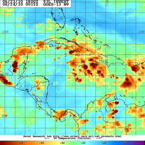
The latest microwave does show a lot better rotation but with the lack of consistent activity around the rotation, it makes it hard for anything to really develop.

http://www.ssd.noaa.gov/goes/flt/t1/flash-wv.html
http://www.ssd.noaa.gov/goes/flt/t1/flash-wv.html
For Your Infinite Source For All Things Weather Visit Our Facebook
-
srainhoutx

- Site Admin
- Posts: 19700
- Joined: Tue Feb 02, 2010 2:32 pm
- Location: Maggie Valley, NC
- Contact:
Code: Select all
WHXX01 KWBC 231929
CHGHUR
TROPICAL CYCLONE GUIDANCE MESSAGE
NWS TPC/NATIONAL HURRICANE CENTER MIAMI FL
1929 UTC WED JUN 23 2010

DISCLAIMER...NUMERICAL MODELS ARE SUBJECT TO LARGE ERRORS.
PLEASE REFER TO NHC OFFICIAL FORECASTS FOR TROPICAL CYCLONE
AND SUBTROPICAL CYCLONE INFORMATION.

ATLANTIC OBJECTIVE AIDS FOR

DISTURBANCE INVEST (AL932010) 20100623 1800 UTC

        ...00 HRS...   ...12 HRS...   ...24 HRS. ..   ...36 HRS...
        100623  1800   100624  0600   100624  1800   100625  0600

         LAT    LON     LAT    LON     LAT    LON     LAT    LON
BAMS    16.6N  78.6W   16.7N  80.7W   17.1N  82.5W   17.2N  83.9W
BAMD    16.6N  78.6W   16.6N  80.0W   16.6N  81.4W   16.6N  82.8W
BAMM    16.6N  78.6W   16.6N  80.3W   16.8N  81.8W   16.9N  83.1W
LBAR    16.6N  78.6W   17.0N  80.6W   17.5N  82.9W   18.2N  85.3W
SHIP        25KTS          28KTS          32KTS          40KTS
DSHP        25KTS          28KTS          32KTS          40KTS

        ...48 HRS...   ...72 HRS...   ...96 HRS. ..   ..120 HRS...
        100625  1800   100626  1800   100627  1800   100628  1800

         LAT    LON     LAT    LON     LAT    LON     LAT    LON
BAMS    17.7N  85.3W   19.0N  87.8W   20.6N  90.2W   21.7N  92.7W
BAMD    16.8N  84.4W   17.2N  87.6W   17.6N  90.9W   17.7N  94.2W
BAMM    17.1N  84.4W   17.9N  87.2W   18.7N  90.0W   19.1N  93.0W
LBAR    19.1N  87.7W   21.0N  91.8W   23.1N  94.1W   25.1N  94.7W
SHIP        50KTS          66KTS          78KTS          88KTS
DSHP        50KTS          66KTS          35KTS          39KTS

         ...INITIAL CONDITIONS...
LATCUR =  16.6N LONCUR =  78.6W DIRCUR = 285DEG SPDCUR =  11KT
LATM12 =  15.7N LONM12 =  76.3W DIRM12 = 281DEG SPDM12 =  11KT
LATM24 =  15.4N LONM24 =  74.0W
WNDCUR =   25KT RMAXWD =   75NM WNDM12 =   25KT
CENPRS = 1010MB OUTPRS = 1012MB OUTRAD =  120NM SDEPTH =   S
RD34NE = 0NM RD34SE = 0NM RD34SW = 0NM RD34NW = 0NM 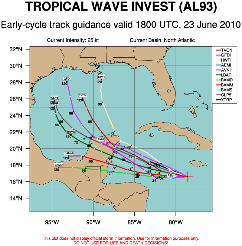
Carla/Alicia/Jerry(In The Eye)/Michelle/Charley/Ivan/Dennis/Katrina/Rita/Wilma/Humberto/Ike/Harvey
Member: National Weather Association
Facebook.com/Weather Infinity
Twitter @WeatherInfinity
Member: National Weather Association
Facebook.com/Weather Infinity
Twitter @WeatherInfinity

-
srainhoutx
- Site Admin
- Posts: 19700
- Joined: Tue Feb 02, 2010 2:32 pm
- Location: Maggie Valley, NC
- Contact:
Carla/Alicia/Jerry(In The Eye)/Michelle/Charley/Ivan/Dennis/Katrina/Rita/Wilma/Humberto/Ike/Harvey
Member: National Weather Association
Facebook.com/Weather Infinity
Twitter @WeatherInfinity
Member: National Weather Association
Facebook.com/Weather Infinity
Twitter @WeatherInfinity
-
srainhoutx
- Site Admin
- Posts: 19700
- Joined: Tue Feb 02, 2010 2:32 pm
- Location: Maggie Valley, NC
- Contact:
HPC thoughts this afternoon...
AHEAD OF THIS EVOLVING EASTERN TROUGH THE 00Z UKMET APPEARS BEST
PER MULTI-MODEL ENSEMBLE CLUSTERING IN REGARDS TO THE AREA OF LOW
PRESSURE TRACKING EASTWARD FROM THE PLAINS THROUGH THE
NORTHEAST...LYING IN BETWEEN THE 12Z UKMET AND 12Z GFS. MEANWHILE
MODELS/ENSEMBLES DEFINE AN INCREASINGLY WIDE ENVELOPE WITH A
POSSIBLE TROPICAL SYSTEM EMERGING FROM THE CARIBBEAN INTO THE GULF
OF MEXICO... WITH THE 00Z ECMWF BY FAR THE DEEPEST AS THE SYSTEM
TRACKS OVER THE GULF AND THE 00Z/12Z CANADIAN THE QUICKEST WITH
ITS PROGRESSION THROUGH THE SOUTHEAST. USING CLIMATOLOGY AND THE
00Z MULTI-MODEL ENSEMBLE GUIDANCE AS A GUIDE...THERE IS A 20-30
PERCENT CHANCE THAT IF A TROPICAL LOW/CYCLONE FORMED AND MOVED
INTO THE NORTHERN GULF OF MEXICO IN 5-6 DAYS THAT IT WOULD RECURVE
INTO THE EASTERN GULF COAST...PARTICULARLY IF THE MORE
WESTERLY/DEEPER SOLUTIONS WITH THE EASTERN TROUGH VERIFY. FOR
NOW...THIS POSSIBILITY IS CONSIDERED A LOW PROBABILITY ALTERNATIVE
SCENARIO SINCE THE GUIDANCE APPEARS TO BE GETTING LESS BULLISH
WITH ITS DEVELOPMENT BY THE DAY...AND IT CURRENTLY SHOWS NO
ORGANIZATION. THE 16Z TPC/HPC COORDINATED TRACK WAS SHIFTED A BIT
TO THE SOUTHWEST DUE TO THE BETTER-AGREED UPON RIDGING EXPECTED TO
LINGER AT 500 HPA ALONG THE GULF COAST LATE IN THE PERIOD...WHICH
MOVES THE LOW CLOSE TO THE CENTER OF THE LARGER CAMP OF ENSEMBLE
LOW CLUSTERING.
Carla/Alicia/Jerry(In The Eye)/Michelle/Charley/Ivan/Dennis/Katrina/Rita/Wilma/Humberto/Ike/Harvey
Member: National Weather Association
Facebook.com/Weather Infinity
Twitter @WeatherInfinity
Member: National Weather Association
Facebook.com/Weather Infinity
Twitter @WeatherInfinity
-
Ptarmigan

- Statistical Specialist

- Posts: 4521
- Joined: Wed Feb 03, 2010 7:20 pm
- Contact:
I think 93L will be at most a tropical storm.


-
srainhoutx
- Site Admin
- Posts: 19700
- Joined: Tue Feb 02, 2010 2:32 pm
- Location: Maggie Valley, NC
- Contact:
S of Jamaica...Hmmm...
Carla/Alicia/Jerry(In The Eye)/Michelle/Charley/Ivan/Dennis/Katrina/Rita/Wilma/Humberto/Ike/Harvey
Member: National Weather Association
Facebook.com/Weather Infinity
Twitter @WeatherInfinity
Member: National Weather Association
Facebook.com/Weather Infinity
Twitter @WeatherInfinity
-
ticka1
- Posts: 1265
- Joined: Wed Feb 03, 2010 3:02 pm
- Location: Baytown/Mont Belvieu
- Contact:
maybe just maybe srainhoutx....you know i remember why i don't like hurricane season .... either form or die. That's my motto. This lolly-gagging around is so nerve-racking!

-
srainhoutx
- Site Admin
- Posts: 19700
- Joined: Tue Feb 02, 2010 2:32 pm
- Location: Maggie Valley, NC
- Contact:
Part of life in the NW Gulf ticka1. Like it or not.
Carla/Alicia/Jerry(In The Eye)/Michelle/Charley/Ivan/Dennis/Katrina/Rita/Wilma/Humberto/Ike/Harvey
Member: National Weather Association
Facebook.com/Weather Infinity
Twitter @WeatherInfinity
Member: National Weather Association
Facebook.com/Weather Infinity
Twitter @WeatherInfinity
-
ticka1
- Posts: 1265
- Joined: Wed Feb 03, 2010 3:02 pm
- Location: Baytown/Mont Belvieu
- Contact:
The older I get the crankier I get during cane season!!!! Oh well - life as it is along the texas coast!!!!srainhoutx wrote:Part of life in the NW Gulf ticka1. Like it or not.
-
biggerbyte
- Posts: 1437
- Joined: Thu Feb 04, 2010 12:15 am
- Location: Porter, Texas. (Montgomery County)
- Contact:
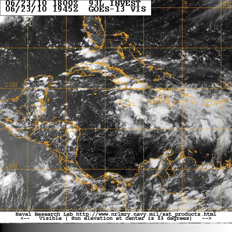
Watch the area around Jamaica, folks. Pressures are dropping, and there appears to be some circulation forming. Tonight, through the weekend could be when 93l finally wakes up.
-
wxman57

- Global Moderator

- Posts: 2621
- Joined: Thu Feb 04, 2010 5:34 am
- Location: Southwest Houston (Westbury)
- Contact:
Just in the last few hours, I'm seeing signs of organization south of Jamaica. Squalls are diminishing near the two mid-level centers to the east and concentrating south of Jamaica. Could be the beginning of something. Let's see if it continues tonight and tomorrow.
I think it has at least a 50% shot at developing. No want to be confident where it may eventually end up, though. But with that trof digging down into the Gulf next week, it could well be moving NNE or even NE when it makes landfall. That is, IF the trof picks it up. Everyone needs to pay attention to this one.
I think it has at least a 50% shot at developing. No want to be confident where it may eventually end up, though. But with that trof digging down into the Gulf next week, it could well be moving NNE or even NE when it makes landfall. That is, IF the trof picks it up. Everyone needs to pay attention to this one.
-
ticka1
- Posts: 1265
- Joined: Wed Feb 03, 2010 3:02 pm
- Location: Baytown/Mont Belvieu
- Contact:
Thank you for posting wxman57 - I know you are busy but your posts are always right on.
-
Ptarmigan
- Statistical Specialist
- Posts: 4521
- Joined: Wed Feb 03, 2010 7:20 pm
- Contact:
Hmmmmmmmmm......... Looks like it is getting better organized. We shall see.wxman57 wrote:Just in the last few hours, I'm seeing signs of organization south of Jamaica. Squalls are diminishing near the two mid-level centers to the east and concentrating south of Jamaica. Could be the beginning of something. Let's see if it continues tonight and tomorrow.
I think it has at least a 50% shot at developing. No want to be confident where it may eventually end up, though. But with that trof digging down into the Gulf next week, it could well be moving NNE or even NE when it makes landfall. That is, IF the trof picks it up. Everyone needs to pay attention to this one.

-
Paul

- Posts: 535
- Joined: Wed Feb 03, 2010 11:46 pm
- Location: Pearland
- Contact:
I think 93l has started to consolidate some tonight. With no MLC to contend with I think it might get going finally...
-
txsnowmaker
- Posts: 733
- Joined: Wed Feb 03, 2010 4:07 pm
- Location: SW Houston (Galleria area)
- Contact:
If this were to develop, how soon next week could areas along the Gulf Coast start to experience tropical conditions? Do most models still project an earliest landfall around Tuesday-Wednesday?