
April 2017 - MS 150 Forecast This Weekend
-
Rip76

- Posts: 2126
- Joined: Mon Feb 15, 2010 12:38 am
- Location: The Woodlands
- Contact:
That seems a little better for us.
-
ticka1
- Posts: 1265
- Joined: Wed Feb 03, 2010 3:02 pm
- Location: Baytown/Mont Belvieu
- Contact:
what timeframe we looking at for serious weather?
-
StormOne

- Posts: 99
- Joined: Thu May 19, 2016 9:35 pm
- Location: Lincoln, NE
- Contact:
Keep in mind that even if the threat appears to die down in the models, something different may happen. This is the type of thing where nobody will know what the weather will do until after the fact. Ingredients still look pretty impressive despite dropping a bit. Continue being weather aware and heed all watches & warnings issued tomorrow. It will be relatively hard for storms to form, but many storms that do form will likely be many discrete supercells.
Last edited by StormOne on Sat Apr 01, 2017 10:43 pm, edited 1 time in total.
A transplant from Houston to Lincoln, Nebraska.
-
sau27
- Posts: 415
- Joined: Sat Apr 24, 2010 12:04 am
- Location: Bellaire
- Contact:
If my memory is correct didn't the meso models show the storms on Wednesday dying down before or as they resched our area. With the very rare confluence of ingredients in place the models being off by a few miles could make a huge difference.
-
StormOne
- Posts: 99
- Joined: Thu May 19, 2016 9:35 pm
- Location: Lincoln, NE
- Contact:
It is really hard to pin that down. Stay aware the entire day tomorrow, let's put it that way. Maybe the mets with a degree on here can give a better answer, but I am seeing many different models say many different things right now. The possibility does exist that maybe this busts and SE TX escapes from this completely unscathed. The possibility also exists that there could be violent discrete supercells. There are models showing both of those cases and everything in between. That's why exact timing is hard to pin down. If we're going for the worst case scenario here, tornado threat would be highest in the morning but not necessarily go away throughout the day. I'm not too worried about flooding as everything should be fast moving in nature, especially if the parent line doesn't make it down to Houston. Definitely don't let your guard down, but hope for the best.ticka1 wrote:what timeframe we looking at for serious weather?
A transplant from Houston to Lincoln, Nebraska.
-
DoctorMu

- Posts: 8016
- Joined: Sun Jun 28, 2015 11:58 am
- Location: College Station
- Contact:
Yeah, I would not go to bed complacent. Lots of uncertainty in a complex forecast. Highest CAPE is to the SW and pockets of shear in Ft. Bend Co per GFS as well as the greatest shear from Hempstead and Conroe up NE to Lufkin. Waiting for the 00z GFS to complete.sau27 wrote:If my memory is correct didn't the meso models show the storms on Wednesday dying down before or as they resched our area. With the very rare confluence of ingredients in place the models being off by a few miles could make a huge difference.
Tornados have overperformed in Harris Co so far this year, so keep a wary eye. TWC asleep at the wheel as usual.
-
Rip76
- Posts: 2126
- Joined: Mon Feb 15, 2010 12:38 am
- Location: The Woodlands
- Contact:
TWC is always asleep.
-
DoctorMu
- Posts: 8016
- Joined: Sun Jun 28, 2015 11:58 am
- Location: College Station
- Contact:
Pretty much. When they got caught with their pants down during that huge ice storm in ATL, that was an embarrassing black eye. Should have been a clue to refocus on the weather. $$ talks though...Rip76 wrote:TWC is always asleep.
-
ticka1
- Posts: 1265
- Joined: Wed Feb 03, 2010 3:02 pm
- Location: Baytown/Mont Belvieu
- Contact:
Going to church and errands - hope to be home before all starts at 10:30 amStormOne wrote:It is really hard to pin that down. Stay aware the entire day tomorrow, let's put it that way. Maybe the mets with a degree on here can give a better answer, but I am seeing many different models say many different things right now. The possibility does exist that maybe this busts and SE TX escapes from this completely unscathed. The possibility also exists that there could be violent discrete supercells. There are models showing both of those cases and everything in between. That's why exact timing is hard to pin down. If we're going for the worst case scenario here, tornado threat would be highest in the morning but not necessarily go away throughout the day. I'm not too worried about flooding as everything should be fast moving in nature, especially if the parent line doesn't make it down to Houston. Definitely don't let your guard down, but hope for the best.ticka1 wrote:what timeframe we looking at for serious weather?
-
Andrew
- Site Admin

- Posts: 3508
- Joined: Wed Feb 03, 2010 9:46 pm
- Location: North-West Houston
- Contact:
Going to be interesting to see what the SPC does with the 1 day outlook. Highest ceilings still exist on the southern side of SE Texas and the global models still show development along the I-10 corridor. Looking at the soundings capping doesn't look too extreme so I wonder why little to know development occurs further south. If all the parameters come together right this definitely has a high risk potential but too many questions still exist (in my opinion) to declare one yet. I also don't think the convective allowing models still have the greatest handle on things. With that said I do believe the northern edge of the moderate risk has the best chance for seeing severe weather as it stands right now but any discrete cells that form to the south will be dangerous.
For Your Infinite Source For All Things Weather Visit Our Facebook
-
DoctorMu
- Posts: 8016
- Joined: Sun Jun 28, 2015 11:58 am
- Location: College Station
- Contact:
Latest NAM. Besides for NO of I-10 and E of I-35, concerned about SW of HOU as well. Timing and complexity make it hard to pin down when supercell may form and where...


-
Andrew
- Site Admin
- Posts: 3508
- Joined: Wed Feb 03, 2010 9:46 pm
- Location: North-West Houston
- Contact:
SPC has moved the moderate risk to the Northeast
"Day 1 Convective Outlook
NWS Storm Prediction Center Norman OK
0100 AM CDT Sun Apr 02 2017
Valid 021200Z - 031200Z
...THERE IS A MODERATE RISK OF SEVERE THUNDERSTORMS FOR EAST
TEXAS...CENTRAL AND NORTHERN LOUISIANA...AND FAR SOUTHWEST
MISSISSIPPI...
...THERE IS AN ENHANCED RISK OF SEVERE THUNDERSTORMS FOR PORTIONS OF
CENTRAL TEXAS AND MUCH OF EAST TEXAS EASTWARD INTO SOUTHERN ARKANSAS
AND CENTRAL MISSISSIPPI...
...THERE IS A SLIGHT RISK OF SEVERE THUNDERSTORMS FROM CENTRAL TEXAS
INTO THE LOWER MISSISSIPPI VALLEY...
...THERE IS A MARGINAL RISK OF SEVERE THUNDERSTORMS SURROUNDING THE
SLIGHT RISK...
...SUMMARY...
Numerous severe thunderstorms are forecast from parts of Texas
eastward into the lower Mississippi Valley today and into tonight.
A concentrated area of significant wind damage is likely near and
north of the I-20 corridor in east Texas and Louisiana. The risk
for tornadoes, a few of which may be strong/damaging, will probably
maximize near and south of I-20 in Texas and Louisiana, along with
the threat for hail.
...Synopsis...
A closed mid-level low will evolve into an open wave and move from
northern Mexico/Far West TX eastward to the ArkLaTex by early Monday
morning. A broad area of surface low pressure over the Rio Grande
Valley will consolidate and develop northeast across central TX
during the day and be near the OK/AR border at the end of the
period. A maritime warm front will advance northward across the
northwest Gulf Coast region during the day as a cold front
accelerates eastward across central TX during the afternoon and into
LA during the overnight.
...Central TX eastward into the lower MS Valley...
A multi-hazard, likely multi-scenario forecast with intrinsic
complexity/uncertainty is seemingly evident for today into tonight.
Late Saturday evening surface analysis and radar imagery show rich
low-level moisture over the TX coast with a developing thunderstorm
cluster in the middle Rio Grande Valley. Strong to severe
thunderstorms will likely be ongoing over central TX. Severe
gusts/wind damage appears to be the predominate threat with the
early-day MCS. As the surface low deepens, a concurrent strong
low-level mass response will occur and the development of a 50-kt
LLJ by mid morning is expected. Strong low-level moist advection on
the nose of the LLJ will be favorable for a continuation of early
morning storms as the LLJ's terminus shifts eastward from
east-central TX into the ArkLaTex by mid-late afternoon. A
concentrated zone of higher probability wind potential may be
realized with a potential bowing system as increasing buoyancy
(1000-3000 J/kg MUCAPE) and strong shear lead to an intense bowing
MCS moving from TX into the ArkLaTex.
Coincident with the diurnal heating cycle, free warm sector
thunderstorm initiation is likely from east TX into LA on the
northern rim of the elevated mixed layer's stronger capping
inversion (north of Interstate 10). Persistent south-to-north
oriented confluence zones in the warm sector will serve as the
genesis areas with gradual thunderstorm/supercell development as
stronger updrafts penetrate the LFC---beginning as early as the late
morning and through the afternoon. A moderate to very unstable
boundary layer (MLCAPE ranging from 2000-3000 J/kg) is forecast from
eastern parts of TX into LA. Forecast soundings show large
hodographs (200-400 m2/s2 0-1 km SRH) with strong effective shear of
at least 50-kt. It seems plausible several supercells may evolve
from this activity and pose a threat for tornadoes and large to very
large hail. A couple of strong/damaging tornadoes are possible.
The latest model guidance suggests thunderstorm coverage will be
less generally south of Interstate 10. Nonetheless, models show
isolated to widely scattered storms developing perhaps in
conjunction with stronger deep forcing for ascent.
During the evening and overnight over the lower MS Valley, storms
will likely spread into the region from the west. Increasing
moisture/buoyancy as the maritime front advances northward will
favor an organized severe storm risk continuing into the region.
Thunderstorms within the strong flow fields will conditionally
support the possibility for wind damage and tornadoes after dark."
For Your Infinite Source For All Things Weather Visit Our Facebook
-
ticka1
- Posts: 1265
- Joined: Wed Feb 03, 2010 3:02 pm
- Location: Baytown/Mont Belvieu
- Contact:
bust?
-
unome
- Posts: 3062
- Joined: Fri Feb 12, 2010 6:11 pm
wish we had access to GOES-16 lightning mapper, their satellite images are incredible
http://en.blitzortung.org/live_lightnin ... php?map=31
https://www.lightningmaps.org/blitzortu ... _maps_form
http://atmo.tamu.edu/ciams/lma/network_loop.html
http://en.blitzortung.org/live_lightnin ... php?map=31
https://www.lightningmaps.org/blitzortu ... _maps_form
http://atmo.tamu.edu/ciams/lma/network_loop.html
Last edited by unome on Sun Apr 02, 2017 6:05 am, edited 1 time in total.
-
unome
- Posts: 3062
- Joined: Fri Feb 12, 2010 6:11 pm
http://www.spc.noaa.gov/products/md/2017/md0398.html
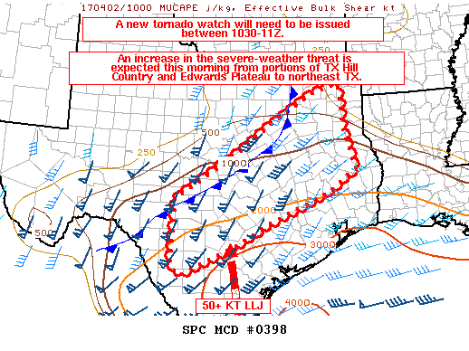
Mesoscale Discussion 0398
NWS Storm Prediction Center Norman OK
0516 AM CDT Sun Apr 02 2017
Areas affected... South-central to northeast TX
Concerning... Severe potential... Watch likely
Valid 021016Z - 021215Z
Probability of Watch Issuance...95 percent
SUMMARY... A new tornado watch will be issued by 1030-11Z for portions of south-central to northeast TX. All severe hazards will be possible through this morning into the afternoon across the discussion area.
DISCUSSION...Ongoing strong to severe storms located in central and southwest portions of WW 107 are embedded within an MCS with the likelihood for MCV formation in this complex, given an extended period of latent heat release. Meanwhile, additional cloud-top cooling per IR satellite imagery and reflectivity developing from the vicinity of KAUS to KHOU is occurring within strengthening low-level warm air advection on the north edge of the surface warm sector. A strengthening and veering low-level jet has maintained rich moisture return across south-central into central and southeast TX overnight, with ongoing destabilization expected to persist through the morning into the afternoon across the discussion area. Strengthening vertically veering winds with the approach of the mid-upper level trough into southwest and central TX will sustain strong bulk shear and increasing low-level shear to support both bowing lines and supercells. Surface-based supercells will become more probable across the northern extent of the warm sector toward midday. There will be a gradual increase in damaging winds, hail, and tornado threats through the day.
..Peters/Thompson.. 04/02/2017
ATTN... WFO... LCH... SHV... HGX... FWD... CRP... EWX... SJT...
-
unome
- Posts: 3062
- Joined: Fri Feb 12, 2010 6:11 pm
-
BlueJay
- Posts: 938
- Joined: Tue Mar 04, 2014 10:47 am
- Location: Alden Bridge-The Woodlands, Texas
- Contact:
We have some heavy rain now with lightening and a dab of thunder. Good morning!
-
DoctorMu
- Posts: 8016
- Joined: Sun Jun 28, 2015 11:58 am
- Location: College Station
- Contact:
Tornado Warning now issued for Waller!Andrew wrote:Keep an eye on the Waller cell.
Edit to add it is now tornado warned.