http://www.spc.noaa.gov/products/md/2017/md0180.html
Mesoscale Discussion 0180
NWS Storm Prediction Center Norman OK
0833 AM CST Tue Feb 14 2017
Areas affected...Portions of the Upper TX Coast and vicinity
Concerning...Tornado Watch 32...
Valid 141433Z - 141500Z
The severe weather threat for Tornado Watch 32 continues.
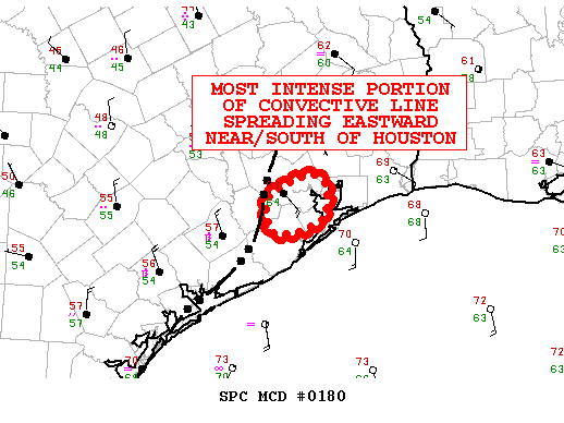
SUMMARY...The most intense segment of a quasi-linear convective
system will move through locations near and south of the Houston
area through 16Z. Damaging winds and a few tornadoes are possible.
DISCUSSION...The most prominent rear-inflow surges and flanking
mesovortices attendant to a broader squall line crossing southeast
TX will move through areas near/south of the Houston area through
16Z. The HGX VAD wind profile indicates ample low-level SRH (around
250-300 m2/s2 in the 0-1-km layer), aided by veering winds with
height. Sufficient moisture influx ahead of the line (dewpoints in
the middle 60s) will support enough buoyancy for a continued
damaging wind risk, and line-embedded circulations may pose a
tornado risk with this most intense portion of the convective
system. This could affect the Houston area and locations to the
south.
..Cohen.. 02/14/2017
ATTN...WFO...HGX...