
I think it is quite well established that dryness can come to much of the state during summer, but I never had perspective on the degree until recently.
Just take a look at Austin:
https://en.wikipedia.org/wiki/Austin,_Texas#Climate
July/August rainfall in Austin is so infrequent, that even a desert like Phoenix receives nearly as frequent rainfall (in fact, its August frequency is higher than Austin's):
https://en.wikipedia.org/wiki/Phoenix,_Arizona#Climate
Same goes for areas like Waco, Dallas, San Antonio. Even inland East Texas has the same tendency to summer dryness (albeit softened); Tyler, Texarkana, etc.
Is a "Death Ridge" a normal occurrence for these areas during summer? If so, what geographic reason is there for it (especially considering much of the region lacks super high mountains that can alter atmospheric patterns)? Is there even a geographic reason, or was it just a pure bad luck?
You have to go to SE Texas/coast to get a more regular rainfall pattern. Houston (areas not too far inland), Beaumont, and Port Arthur all have more frequent rainfall in summer than in the other seasons (with winter having the second highest frequency), and all break the Texas trend of spring/fall rainfall peaks (because all have higher average rainfall frequency in the summer compared to spring/fall). The rest of the Texas Gulf also features a summer peak (Brownsville, Corpus, etc), but just limited to August/September.
Texas Summers Are Weird
-
DoctorMu

- Posts: 8016
- Joined: Sun Jun 28, 2015 11:58 am
- Location: College Station
- Contact:
-
A.V.
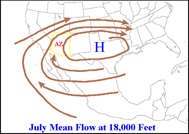
I'm not sure about that. AZ's monsoon is just the subtropical ridge moving north enough to stream moisture from the Californian Gulf, and the mean position for that ridge is at 4 Corners.
In fact, if Texas were the normal position, then the ridge would be too far east to give AZ their monsoon.
In fact, if Texas were the normal position, then the ridge would be too far east to give AZ their monsoon.
-
DoctorMu
- Posts: 8016
- Joined: Sun Jun 28, 2015 11:58 am
- Location: College Station
- Contact:
Differential heating of the Mexican desert and Pacific Ocean plays a key role but...


-
A.V.
The same ridge often associates with the Four Corners region, hence the name "Four Corner's High.

Article:
http://extension.arizona.edu/sites/exte ... az1417.pdf
From your own pics, it seems that if anywhere in Texas is affected, on average, by a regular "Death Ridge", it is the northern areas of the state (North Texas, Panhandle); the high looks to be north of the Gulf Coast/Southern Texas, which would allow easterly flow from the Gulf.
This final map is indeed quite telling; it is a late Spring rainfall/summer temp correlation map:

https://weather.com/science/weather-exp ... res-plains
The entire state is in the highest correlation zone except for 2 zones: far western Texas, and the Gulf Coast (a portion of the coast appears marked as highest, but skewed because the district includes a huge chunk of land away from the Gulf). SE Texas sticks out as a sore thumb, very low correlation (the same as the FL Panhandle).
Article:
http://extension.arizona.edu/sites/exte ... az1417.pdf
From your own pics, it seems that if anywhere in Texas is affected, on average, by a regular "Death Ridge", it is the northern areas of the state (North Texas, Panhandle); the high looks to be north of the Gulf Coast/Southern Texas, which would allow easterly flow from the Gulf.
This final map is indeed quite telling; it is a late Spring rainfall/summer temp correlation map:
https://weather.com/science/weather-exp ... res-plains
The entire state is in the highest correlation zone except for 2 zones: far western Texas, and the Gulf Coast (a portion of the coast appears marked as highest, but skewed because the district includes a huge chunk of land away from the Gulf). SE Texas sticks out as a sore thumb, very low correlation (the same as the FL Panhandle).
-
DoctorMu
- Posts: 8016
- Joined: Sun Jun 28, 2015 11:58 am
- Location: College Station
- Contact:
You've conflated a surface high with mid and upper level winds that direct the monsoon. Please observe elevations in the directing flow.
The Death Ridge is a mid to upper level event crushing popcorn showers...say NW of Cypress.
A high temp in the late Spring and summer, usually accompanies dry weather and early manifestation of a strong Death Ridge.
The Death Ridge is a mid to upper level event crushing popcorn showers...say NW of Cypress.
A high temp in the late Spring and summer, usually accompanies dry weather and early manifestation of a strong Death Ridge.
-
A.V.
Nope, I showed the mean position of the Monsoon high, and why it is called the "Four Corners High." Your posted maps of the directing flow only seem to indicate that the northern areas of the state deal with this Death Ridge on a typical basis during summer; South Texas and the coast are spared.DoctorMu wrote:You've conflated a surface high with mid and upper level winds that direct the monsoon. Please observe elevations in the directing flow.
And from the correlation map, you can tell that the entire state, except the coast and the West, deals with this Death Ridge with some levelinas of regularitt, enough that the summer temps are highly dependent on what occurs in Spring.DoctorMu wrote:The Death Ridge is a mid to upper level event crushing popcorn showers...say NW of Cypress.
A high temp in the late Spring and summer, usually accompanies dry weather and early manifestation of a strong Death Ridge.