August 2016: Rain Chances Continue.

General Weather Discussions and Analysis
unome
Posts: 3059
Joined: Fri Feb 12, 2010 6:11 pm

Portastorm wrote:Looks like a long night ahead for us in the I-35 corridor Austin/San Antonio. We're looking at the likelihood of 6-8" of rain with as much as 15" possible in isolated spots. This on already saturated ground. Very sobering language coming out of the EWX office as well as NOAA's WPC excessive rainfall desk. Hope folks pay attention and heed all warnings.
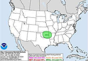
sobering excessive rainfall from WPC:

Image

...TEXAS...

growing very concerned about the ingredients in place that would support a convectively enhanced mid level vortex or mcv... and the associated very strong trend toward excessive rainfall amounts totaling 10 to 15 inches in most of the high resolution guidance. hand analysis of 500 mb reveals a height depression over south texas near del rio... associated with cyclonic curvature seen in radar loops at 19z. this feature is embedded within a plume of tropical moisture that lifted into northern mexico and south texas over the past few days and is now in a region of weak steering flow. the larger scale pattern related to a healthy northern stream trough and sub-tropical ridging along the gulf coast favors persistent upper difluence in the vicinity of the mcv... and also sustained low level inflow. this situation would appear to be ripe for a significant flash flood event... especially given the tendency for this style of event to occur in the texas hill country. therefore... it was not too surprising when the canadian gem regional... the first arriving hi-res guidance... depicted a very wet... nearly stationary mcv and likely flash flood event over the san antonio / austin area. this was followed up by very strong and similar qpf signals in the ncep hi-res windows and nssl wrf. the global models also have heavy rain... especially the ecmwf. the hi-res models and ecmwf support the notion of a 10-plus inch rainfall event occurring from this evening through early sunday. the qpf signal is organized... suggesting some breadth to the extreme rain totals... perhaps affecting multiple counties... rather than being very isolated.

based on the overwhelming model signal and history of rapid hydrologic response in this area... coordinated with texas local offices to upgrade not only to moderate risk... but also to a small high risk area centered around san antonio / austin. placement of the qpf maximum is not of extremely high confidence... but wpc forecasters using independent methods on the night and day shift came up with the same answer for location... which is supported in particular by the wrf-arw... which tends to perform well in south texas. also noted the wrf-arw and wrf-nmm qpf signal indicating nearly 150 percent of the one percent annual exceedance probability or recurrence interval rainfall. with perhaps more people outdoors / on the roads on a saturday night... felt it was prudent to upgrade to high risk to send a clearly heightened message. thanks wfo ewx... fwd... crp... hgx...and southern region for coordination.
User avatar
Katdaddy
Global Moderator
Global Moderator
Posts: 2516
Joined: Thu Feb 04, 2010 8:18 am
Location: League City, Tx
Contact:

Parameters are coming together for major flooding in and around San Antonio and Austin as well as the surrounding Hill Country tonight into Sunday evening. If you have family, friends, and co-workers in that part of state, please make sure they are weather aware. The combination of weak sagging frontal/outflow boundary, Mesoscale Convective Vortex, and mid level disturbance moving out of MX will combine with a deep tropical airmass. A warm core rain event will be possible overnight. Warm core rain events are known for very intense and high rainfall totals. The MCV can be easily seen on satellite this evening near the Austin area. The San Antonio-Austin NWS state it well in this afternoon's Area Forecast Discussion:

...Significant rainfall and flooding probable tonight through
Sunday evening...
Attachments
Screen Shot 2016-08-20 at 5.26.43 PM.png
Screen Shot 2016-08-20 at 5.26.04 PM.png
worrybug

srainhoutx wrote:Saturday afternoon briefing from Jeff:

Main question is how far east and south this organized heavy rainfall moves into SE TX. Models generally keep the heaviest rainfall near our western border into Sunday morning and this is certainly possible given the expected slow storm motions and 500-200mb ridging attempting to build over SE TX from the ESE. However as we have seen with many of these events, the meso scale (outflow boundaries) like to take over and drive convection to the east and south many times deeper into SE TX. Additionally, the deeper moisture channel will be across a larger part of SE TX on Sunday and with heating and boundaries approaching from the N and W the chances for heavy rainfall may move deeper into the region.
Do you personally believe that Houston and surrounding areas will experience the same kind of heavy rain that is predicted for Austin and San Antonio? Or are you just saying this for safety's sake?
User avatar
DoctorMu
Posts: 6513
Joined: Sun Jun 28, 2015 11:58 am
Location: College Station
Contact:

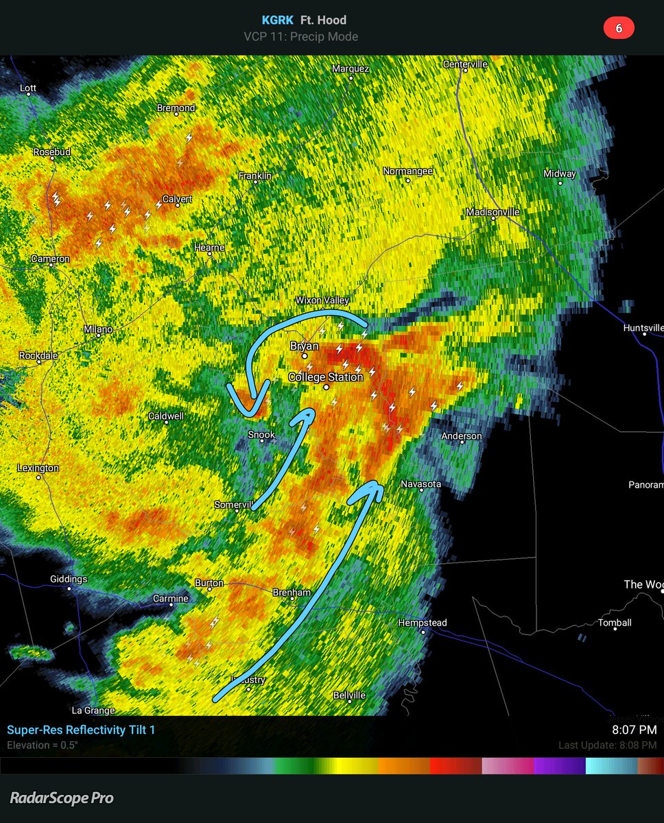
Bow echo closing in on CLL. A bit of a hook near Brenham. Rotation possible, but right now expect some straight line winds.

Also keep an eye out for potential flash flooding as the low moves ENE tonight.


Image


Image
worrybug

DoctorMu wrote:Bow echo closing in on CLL. A bit of a hook near Brenham. Rotation possible, but right now expect some straight line winds.

Also keep an eye out for potential flash flooding as the low moves ENE tonight.


Image


Image

When does this bow echo move into Houston, Doctor Mu? What kind of winds should I expect in my suburb?
User avatar
DoctorMu
Posts: 6513
Joined: Sun Jun 28, 2015 11:58 am
Location: College Station
Contact:

The bow echo is gone and we now see central circulation of the MCV (Mesoscale Convective Vortex. You can see the center approaching Brazos County. We're seeing a fair amount of lightning

Image

Houston may see a straight line of storms as the center of the MCV stays north of HOU

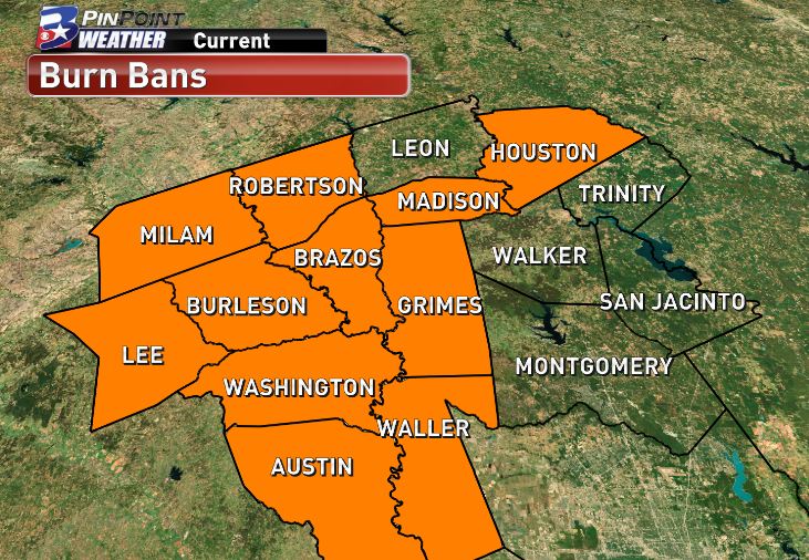
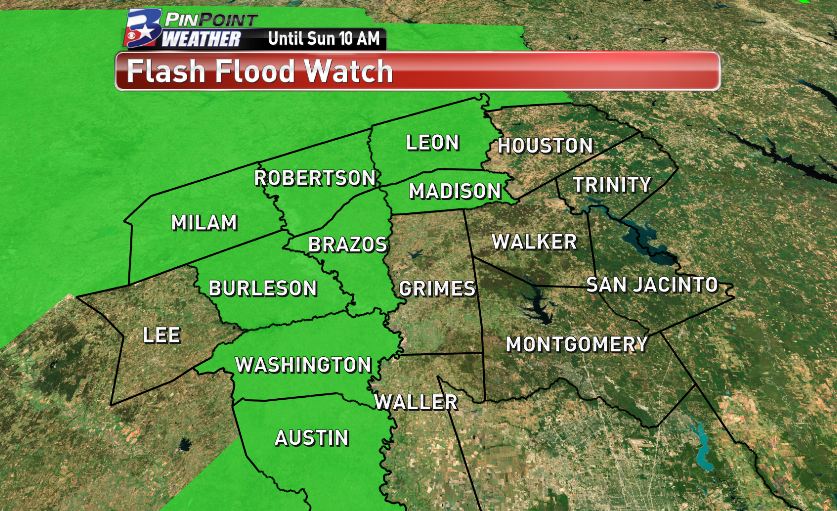
From burn ban to flash flood watch in less than 4 days. Welcome to Texas!

Image

Image
worrybug

DoctorMu wrote:The bow echo is gone and we now see central circulation of the MCV (Mesoscale Convective Vortex. You can see the center approaching Brazos County. We're seeing a fair amount of lightning

Image

Houston may see a straight line of storms as the center of the MCV stays north of HOU

From burn ban to flash flood watch in less than 4 days. Welcome to Texas!

Image

Image

Are you saying we're going to get severe storms here in a few hours, Doc?
User avatar
DoctorMu
Posts: 6513
Joined: Sun Jun 28, 2015 11:58 am
Location: College Station
Contact:

The heavy action should remain north of Harris Co, but expect rain later tonight. Flash Flood for NW counties.

http://www.goes.noaa.gov/GSSLOOPS/ecwv.html


Area Forecast Discussion
National Weather Service Houston/Galveston TX
634 PM CDT Sat Aug 20 2016

.AVIATION...
Not a lot of confidence with the 21/00Z TAFs. A northeast to southwest
oriented line of showers and thunderstorms is moving into the CLL area
early this evening with the best coverage currently in line with the
coldest cloud tops on IR satellite imagery. Cloud tops are cooling with
the activity off to the southwest, and these storms are in line to eventually
move into the CLL and UTS areas this evening.
Through tomorrow morning,
generally have VCTS/TSRA for CLL and UTS, and VCSH/-RA for locations
further to the south. During the day tomorrow, going with SHRA to the
north and TSRA to the south. There are most likely going to be lots
of amendments tonight and tomorrow as this storm system evolves. Mainly
MVFR/IFR ceilings and visibilities are anticipated to develop as storms
move into the area. 42
&&

.PREV DISCUSSION... /ISSUED /

DISCUSSION...
A series of upper level shortwave troughs will move through the
central and eastern portions of the state tonight and Sunday. With
a moisture tap off of the Pacific in the mid and upper levels, and
low-level moisture form the Gulf of Mexico, widespread showers and
thunderstorms will be possible over portions of the forecast area
both periods.

Issuing a flash flood watch for the far northern and western
counties through mid morning on Sunday: Houston, Madison, Brazos,
Burleson, Washington, Austin, and Colorado.
The main event for
heavy rainfall tonight and Sunday will most likely be west of the
CWA over the Hill Country. An MCV currently moving northeastward
across the Hill Country should bring more widespread chances for
showers and thunderstorms into the western and northern portions
of the forecast area.
Water Vapor showed another shortwave trough
moving across northern Mexico which should help trigger additional
thunderstorms later tonight. Model rainfall amounts for Southeast
Texas for tonight through Sunday range from 1 to 3 inches with
isolated higher amounts generally along and west of a line from
Crockett to College Station to Columbus. The most likely time
period for locally heavy rainfall will be this evening through mid
Sunday morning.

Good chances for rainfall continue into Monday with the corridor
of deep layer moisture finally moving away from the area by Monday
night as the mid and upper level ridge build into the state from
the east. This will in turn mean lower rain chances and warmer
temperatures during the mid and latter parts of the upcoming week.
User avatar
DoctorMu
Posts: 6513
Joined: Sun Jun 28, 2015 11:58 am
Location: College Station
Contact:

worrybug wrote:
DoctorMu wrote:

Are you saying we're going to get severe storms here in a few hours, Doc?

The MCV (rotating blob of heavy rain) should stay north of Houston. A trailing line of storms will provide rain later tonight, but NOAA does not anticipate severe weather. Navasota, College Station, Huntsville are in the path of the MCV...
worrybug

DoctorMu wrote:The heavy action should remain north of Harris Co, but expect rain later tonight. Flash Flood for NW counties.

http://www.goes.noaa.gov/GSSLOOPS/ecwv.html


Area Forecast Discussion
National Weather Service Houston/Galveston TX
634 PM CDT Sat Aug 20 2016

.AVIATION...
Not a lot of confidence with the 21/00Z TAFs. A northeast to southwest
oriented line of showers and thunderstorms is moving into the CLL area
early this evening with the best coverage currently in line with the
coldest cloud tops on IR satellite imagery. Cloud tops are cooling with
the activity off to the southwest, and these storms are in line to eventually
move into the CLL and UTS areas this evening.
Through tomorrow morning,
generally have VCTS/TSRA for CLL and UTS, and VCSH/-RA for locations
further to the south. During the day tomorrow, going with SHRA to the
north and TSRA to the south. There are most likely going to be lots
of amendments tonight and tomorrow as this storm system evolves. Mainly
MVFR/IFR ceilings and visibilities are anticipated to develop as storms
move into the area. 42
&&

.PREV DISCUSSION... /ISSUED /

DISCUSSION...
A series of upper level shortwave troughs will move through the
central and eastern portions of the state tonight and Sunday. With
a moisture tap off of the Pacific in the mid and upper levels, and
low-level moisture form the Gulf of Mexico, widespread showers and
thunderstorms will be possible over portions of the forecast area
both periods.

Issuing a flash flood watch for the far northern and western
counties through mid morning on Sunday: Houston, Madison, Brazos,
Burleson, Washington, Austin, and Colorado.
The main event for
heavy rainfall tonight and Sunday will most likely be west of the
CWA over the Hill Country. An MCV currently moving northeastward
across the Hill Country should bring more widespread chances for
showers and thunderstorms into the western and northern portions
of the forecast area.
Water Vapor showed another shortwave trough
moving across northern Mexico which should help trigger additional
thunderstorms later tonight. Model rainfall amounts for Southeast
Texas for tonight through Sunday range from 1 to 3 inches with
isolated higher amounts generally along and west of a line from
Crockett to College Station to Columbus. The most likely time
period for locally heavy rainfall will be this evening through mid
Sunday morning.

Good chances for rainfall continue into Monday with the corridor
of deep layer moisture finally moving away from the area by Monday
night as the mid and upper level ridge build into the state from
the east. This will in turn mean lower rain chances and warmer
temperatures during the mid and latter parts of the upcoming week.

Rain with serious winds and lightning, Doc?

Item: I am not in any of the areas mentioned in the AFD. I'm in southwest Houston, below I-10. Assuming that has anything to do with anything, of course.
unome
Posts: 3059
Joined: Fri Feb 12, 2010 6:11 pm

http://www.wpc.ncep.noaa.gov/metwatch/metwatch_mpd.php

Image

MESOSCALE PRECIPITATION DISCUSSION 0587
NWS WEATHER PREDICTION CENTER COLLEGE PARK MD
900 PM EDT SAT AUG 20 2016

AREAS AFFECTED...PORTIONS OF SOUTH-CENTRAL AND SOUTHEAST TX

CONCERNING...HEAVY RAINFALL...FLASH FLOODING LIKELY

VALID 210100Z - 210700Z

SUMMARY...EXTREMELY HEAVY RAINFALL WILL BE LIKELY THIS EVENING
INTO THE OVERNIGHT HOURS...WITH SIGNIFICANT AND POSSIBLY
LIFE-THREATENING FLASH FLOODING EXPECTED.

DISCUSSION...LATE-DAY VISIBLE SATELLITE IMAGERY SHOWS A VERY
WELL-DEFINED AND COMPACT MCV ACTUALLY MOVING SOMEWHAT
PROGRESSIVELY OFF TO THE EAST-NORTHEAST OUT OF THE TX HILL COUNTRY
AND TOWARD SOUTHEAST TX. HOWEVER...WHILE THE MCV IS GENERATING A
CONCENTRATED AREA OF CONVECTION WITH VERY INTENSE RAINFALL
RATES...THERE IS AN EXTENDED AXIS OF STRONG THUNDERSTORMS WITH
VERY INTENSE RAINFALL THAT HAS SET UP AROUND THE SOUTHWEST FLANK
OF THE MCV...EXTENDING FROM JUST WEST OF BRENHAM TO FAYETTE AND
THEN DOWN TO THE SOUTHERN SUBURBS OF SAN ANTONIO. THIS SW/NE
ORIENTED BAND OF CONVECTION COINCIDES WITH A WELL-DEFINED
CONVECTIVELY REINFORCED BOUNDARY THAT IS INTERCEPTING VERY MOIST
AND UNSTABLE AIR POOLING NORTH OUT OF SOUTH TX...WITH PWATS OF 2.2
TO 2.4 INCHES AND MLCAPE VALUES OF 2500 J/KG.

THE SET-UP OVERNIGHT FAVORS THE CONTINUATION OF A SW/NE ORIENTED
AXIS OF EXTREMELY HEAVY CONVECTIVE RAINFALL AS THIS SURFACE
BOUNDARY IS EXPECTED TO STALL OUT WHILE COINCIDING WITH A
RELATIVELY DIFFLUENT UPPER FLOW PATTERN AND PERSISTENTLY
MOIST/UNSTABLE BOUNDARY LAYER FOR CONVECTION TO DEVELOP AND REPEAT
OVER THE SAME AREA.

HIRES GUIDANCE GOING BACK TO 12Z/SAT...INCLUDING RUNS OF THE
ARW/NMMB AND NSSL-WRF HAVE BEEN ALL SHOWING A VERY STRONG SIGNAL
FOR EXTREME RAINFALL OVERNIGHT ACROSS PORTIONS OF THE TX HILL
COUNTRY IN PARTICULAR. HOWEVER...RECENT CONVECTIVE TRENDS VIA
SATELLITE AND RADAR SHOW THAT THE MCV HAS BECOME NOTABLY MORE
PROGRESSIVE...AND HAS ALLOWED A LOW LEVEL FOCUS FOR VERY HEAVY
RAINS A BIT FARTHER SOUTH AND EAST OF THESE EARLIER HIRES MODELS.

THE LATEST NCEP HRRR/HRRRP AND ESRL HRRR GUIDANCE SUPPORTS A
SOUTHEASTWARD SHIFT WITH A STRONG FOCUS FROM NEAR AND JUST SOUTH
OF SAN ANTONIO AND NORTHEAST TO NEAR AND JUST EAST OF FAYETTE.
ADDITIONAL RAINFALL AMOUNTS OF AS MUCH AS 4 TO 8 INCHES ARE
EXPECTED THROUGH THE EARLY MORNING HOURS IN VICINITY OF THESE
AREAS...AND WILL BE CAPABLE OF PRODUCING SIGNIFICANT AND POSSIBLY
LIFE-THREATENING FLASH FLOODING.

ADDITIONAL HEAVY RAINS THOUGH WILL REMAIN FOCUSED NEAR THE MCV OFF
TO THE NORTHEAST FOR THE NEXT FEW HOURS WHICH WILL ALSO FOCUS
FLASH FLOODING POTENTIAL FOR AREAS OF SOUTHEAST TX NORTHWEST OF
HOUSTON TX. WILL CONTINUE TO MONITOR.

ORRISON

ATTN...WFO...CRP...EWX...FWD...HGX...LCH...SHV...

ATTN...RFC...WGRFC...

LAT...LON 31629468 30959415 30339442 29729527 29049642
28409769 27889872 27849924 28109966 28509969
29099924 29729859 30249780 30739692 31199603

Á


Last Updated: 904 PM EDT SAT AUG 20 2016
worrybug

unome wrote:http://www.wpc.ncep.noaa.gov/metwatch/metwatch_mpd.php

Image

MESOSCALE PRECIPITATION DISCUSSION 0587
NWS WEATHER PREDICTION CENTER COLLEGE PARK MD
900 PM EDT SAT AUG 20 2016

AREAS AFFECTED...PORTIONS OF SOUTH-CENTRAL AND SOUTHEAST TX

CONCERNING...HEAVY RAINFALL...FLASH FLOODING LIKELY

VALID 210100Z - 210700Z

SUMMARY...EXTREMELY HEAVY RAINFALL WILL BE LIKELY THIS EVENING
INTO THE OVERNIGHT HOURS...WITH SIGNIFICANT AND POSSIBLY
LIFE-THREATENING FLASH FLOODING EXPECTED.

DISCUSSION...LATE-DAY VISIBLE SATELLITE IMAGERY SHOWS A VERY
WELL-DEFINED AND COMPACT MCV ACTUALLY MOVING SOMEWHAT
PROGRESSIVELY OFF TO THE EAST-NORTHEAST OUT OF THE TX HILL COUNTRY
AND TOWARD SOUTHEAST TX. HOWEVER...WHILE THE MCV IS GENERATING A
CONCENTRATED AREA OF CONVECTION WITH VERY INTENSE RAINFALL
RATES...THERE IS AN EXTENDED AXIS OF STRONG THUNDERSTORMS WITH
VERY INTENSE RAINFALL THAT HAS SET UP AROUND THE SOUTHWEST FLANK
OF THE MCV...EXTENDING FROM JUST WEST OF BRENHAM TO FAYETTE AND
THEN DOWN TO THE SOUTHERN SUBURBS OF SAN ANTONIO. THIS SW/NE
ORIENTED BAND OF CONVECTION COINCIDES WITH A WELL-DEFINED
CONVECTIVELY REINFORCED BOUNDARY THAT IS INTERCEPTING VERY MOIST
AND UNSTABLE AIR POOLING NORTH OUT OF SOUTH TX...WITH PWATS OF 2.2
TO 2.4 INCHES AND MLCAPE VALUES OF 2500 J/KG.

THE SET-UP OVERNIGHT FAVORS THE CONTINUATION OF A SW/NE ORIENTED
AXIS OF EXTREMELY HEAVY CONVECTIVE RAINFALL AS THIS SURFACE
BOUNDARY IS EXPECTED TO STALL OUT WHILE COINCIDING WITH A
RELATIVELY DIFFLUENT UPPER FLOW PATTERN AND PERSISTENTLY
MOIST/UNSTABLE BOUNDARY LAYER FOR CONVECTION TO DEVELOP AND REPEAT
OVER THE SAME AREA.

HIRES GUIDANCE GOING BACK TO 12Z/SAT...INCLUDING RUNS OF THE
ARW/NMMB AND NSSL-WRF HAVE BEEN ALL SHOWING A VERY STRONG SIGNAL
FOR EXTREME RAINFALL OVERNIGHT ACROSS PORTIONS OF THE TX HILL
COUNTRY IN PARTICULAR. HOWEVER...RECENT CONVECTIVE TRENDS VIA
SATELLITE AND RADAR SHOW THAT THE MCV HAS BECOME NOTABLY MORE
PROGRESSIVE...AND HAS ALLOWED A LOW LEVEL FOCUS FOR VERY HEAVY
RAINS A BIT FARTHER SOUTH AND EAST OF THESE EARLIER HIRES MODELS.

THE LATEST NCEP HRRR/HRRRP AND ESRL HRRR GUIDANCE SUPPORTS A
SOUTHEASTWARD SHIFT WITH A STRONG FOCUS FROM NEAR AND JUST SOUTH
OF SAN ANTONIO AND NORTHEAST TO NEAR AND JUST EAST OF FAYETTE.
ADDITIONAL RAINFALL AMOUNTS OF AS MUCH AS 4 TO 8 INCHES ARE
EXPECTED THROUGH THE EARLY MORNING HOURS IN VICINITY OF THESE
AREAS...AND WILL BE CAPABLE OF PRODUCING SIGNIFICANT AND POSSIBLY
LIFE-THREATENING FLASH FLOODING.

ADDITIONAL HEAVY RAINS THOUGH WILL REMAIN FOCUSED NEAR THE MCV OFF
TO THE NORTHEAST FOR THE NEXT FEW HOURS WHICH WILL ALSO FOCUS
FLASH FLOODING POTENTIAL FOR AREAS OF SOUTHEAST TX NORTHWEST OF
HOUSTON TX. WILL CONTINUE TO MONITOR.

ORRISON

ATTN...WFO...CRP...EWX...FWD...HGX...LCH...SHV...

ATTN...RFC...WGRFC...

LAT...LON 31629468 30959415 30339442 29729527 29049642
28409769 27889872 27849924 28109966 28509969
29099924 29729859 30249780 30739692 31199603

Á


Last Updated: 904 PM EDT SAT AUG 20 2016
Hey, as long as it stays out of Houston (the worst of it, anyway), that's fine with me.
unome
Posts: 3059
Joined: Fri Feb 12, 2010 6:11 pm

https://twitter.com/iembot_hgx

133
FXUS64 KHGX 210202
AFDHGX

Area Forecast Discussion
National Weather Service Houston/Galveston TX
902 PM CDT Sat Aug 20 2016

.UPDATE...
Per satellite and radar, a mesoscale convective vortex has pushed into Burleson county this evening, pushing a line of rainfall a bit further east than expected into the area. Though far more significant to the west where flash flood warnings have been issued already, IR satellite have at times shown temperatures approaching -80C and dual pol instantaneous rain rates have routinely been above 2 inches per hour, and many times have exceeded 6 inches per hour. Fortunately, the MCV to this point has been moving quickly enough that the highest observations reported to this point have been 2 inches or less. Because of its farther eastward motion, have had to bump PoPs and add Grimes County to the flash flood watch.

At this time, cloud tops have been warming over our area and cooling significantly over EWX's area, indicating that the most extreme rain rates for now are likely to be to our west. However, we now turn our attention to the forward motion of the MCV's tail, which appears to have been slowing per radar. The focus of the night now may be for training of rain along where the line stalls out, where less extreme rain rates may still cause problems when dragged out over a longer duration. Have been conservative for now in extending the watch due to the slower forward progress, but it is worth mentioning that WPC is carrying a moderate risk of excessive rainfall as far east as the northwestern corner of Harris County. Should the line fail to stall into the overnight hours, the watch may need to be extended further to the east. 25
worrybug

unome wrote:https://twitter.com/iembot_hgx

133
FXUS64 KHGX 210202
AFDHGX

Area Forecast Discussion
National Weather Service Houston/Galveston TX
902 PM CDT Sat Aug 20 2016

.UPDATE...
Per satellite and radar, a mesoscale convective vortex has pushed into Burleson county this evening, pushing a line of rainfall a bit further east than expected into the area. Though far more significant to the west where flash flood warnings have been issued already, IR satellite have at times shown temperatures approaching -80C and dual pol instantaneous rain rates have routinely been above 2 inches per hour, and many times have exceeded 6 inches per hour. Fortunately, the MCV to this point has been moving quickly enough that the highest observations reported to this point have been 2 inches or less. Because of its farther eastward motion, have had to bump PoPs and add Grimes County to the flash flood watch.

At this time, cloud tops have been warming over our area and cooling significantly over EWX's area, indicating that the most extreme rain rates for now are likely to be to our west. However, we now turn our attention to the forward motion of the MCV's tail, which appears to have been slowing per radar. The focus of the night now may be for training of rain along where the line stalls out, where less extreme rain rates may still cause problems when dragged out over a longer duration. Have been conservative for now in extending the watch due to the slower forward progress, but it is worth mentioning that WPC is carrying a moderate risk of excessive rainfall as far east as the northwestern corner of Harris County. Should the line fail to stall into the overnight hours, the watch may need to be extended further to the east. 25

Say what?
User avatar
DoctorMu
Posts: 6513
Joined: Sun Jun 28, 2015 11:58 am
Location: College Station
Contact:

unome wrote:https://twitter.com/iembot_hgx

133
FXUS64 KHGX 210202
AFDHGX

Area Forecast Discussion
National Weather Service Houston/Galveston TX
902 PM CDT Sat Aug 20 2016

.UPDATE...
Per satellite and radar, a mesoscale convective vortex has pushed into Burleson county this evening, pushing a line of rainfall a bit further east than expected into the area. Though far more significant to the west where flash flood warnings have been issued already, IR satellite have at times shown temperatures approaching -80C and dual pol instantaneous rain rates have routinely been above 2 inches per hour, and many times have exceeded 6 inches per hour. Fortunately, the MCV to this point has been moving quickly enough that the highest observations reported to this point have been 2 inches or less. Because of its farther eastward motion, have had to bump PoPs and add Grimes County to the flash flood watch.

At this time, cloud tops have been warming over our area and cooling significantly over EWX's area, indicating that the most extreme rain rates for now are likely to be to our west. However, we now turn our attention to the forward motion of the MCV's tail, which appears to have been slowing per radar. The focus of the night now may be for training of rain along where the line stalls out, where less extreme rain rates may still cause problems when dragged out over a longer duration. Have been conservative for now in extending the watch due to the slower forward progress, but it is worth mentioning that WPC is carrying a moderate risk of excessive rainfall as far east as the northwestern corner of Harris County. Should the line fail to stall into the overnight hours, the watch may need to be extended further to the east. 25

Yep - that tail may cause the greatest problem between San Antonio and Victoria, but best to keep an eye out. The MCV has moved faster than anticipated, but watch out for that Balrog Effect with the tail.


Image
Last edited by DoctorMu on Sat Aug 20, 2016 9:31 pm, edited 1 time in total.
User avatar
DoctorMu
Posts: 6513
Joined: Sun Jun 28, 2015 11:58 am
Location: College Station
Contact:

Stay dry in Burleson Co, west of CLL. Turn around. Don't drown.


FLOOD WARNING
NATIONAL WEATHER SERVICE HOUSTON/GALVESTON, TX
828 PM CDT SAT AUG 20 2016

...The National Weather Service in Houston/Galveston has issued a flood warning
for the following rivers...

Middle Yegua Creek near Dime Box affecting the following counties in Texas...
Burleson...Lee


For Middle Yegua Creek at Dime Box, Minor flooding is forecasted.

The current weather is dominated by a several rounds of showers and thunderstorms
that will lead to rises in the creek

PRECAUTIONARY/PREPAREDNESS ACTIONS...

Persons with interests along these streams should keep alert to rising water and
take all precautions to protect their property. Do not drive or walk into
flooded areas the depth and water velocity could be too great for you to cross
safely. Motorists should avoid any water covered roads and find an alternate
route. Livestock and equipment should be removed from the flood plain
immediately.

Stay tuned to NOAA Weather radio or other news sources for further updates.
worrybug

DoctorMu wrote:Stay dry in Burleson Co, west of CLL. Turn around. Don't drown.


FLOOD WARNING
NATIONAL WEATHER SERVICE HOUSTON/GALVESTON, TX
828 PM CDT SAT AUG 20 2016

...The National Weather Service in Houston/Galveston has issued a flood warning
for the following rivers...

Middle Yegua Creek near Dime Box affecting the following counties in Texas...
Burleson...Lee


For Middle Yegua Creek at Dime Box, Minor flooding is forecasted.

The current weather is dominated by a several rounds of showers and thunderstorms
that will lead to rises in the creek

PRECAUTIONARY/PREPAREDNESS ACTIONS...

Persons with interests along these streams should keep alert to rising water and
take all precautions to protect their property. Do not drive or walk into
flooded areas the depth and water velocity could be too great for you to cross
safely. Motorists should avoid any water covered roads and find an alternate
route. Livestock and equipment should be removed from the flood plain
immediately.

Stay tuned to NOAA Weather radio or other news sources for further updates.

I hope we're going to have a better morning than we do a night, Doc.
User avatar
DoctorMu
Posts: 6513
Joined: Sun Jun 28, 2015 11:58 am
Location: College Station
Contact:

Another MCV appears to have formed west of Victoria. Flash flood warnings.

Training and slowly drifting eastward. Reduced verticalthermal gradient near Houston may provide protection against severe weather.


BULLETIN - EAS ACTIVATION REQUESTED
FLASH FLOOD WARNING
NATIONAL WEATHER SERVICE AUSTIN/SAN ANTONIO TX
932 PM CDT SAT AUG 20 2016

THE NATIONAL WEATHER SERVICE IN AUSTIN SAN ANTONIO HAS EXTENDED THE

* FLASH FLOOD WARNING FOR...
WESTERN GONZALES COUNTY IN SOUTH CENTRAL TEXAS...
SOUTHEASTERN GUADALUPE COUNTY IN SOUTH CENTRAL TEXAS...
WILSON COUNTY IN SOUTH CENTRAL TEXAS...
EASTERN ATASCOSA COUNTY IN SOUTH CENTRAL TEXAS...

* UNTIL 200 AM CDT

* AT 929 PM CDT...EMERGENCY MANAGEMENT OFFICIALS REPORTED HEAVY RAIN
AND FLASH FLOODING ACROSS THE WARNED AREA. DOPPLER RADAR ESTIMATES
OVER 6 INCHES OF RAIN HAVE FALLEN NEAR SUTHERLAND
SPRINGS...STOCKDALE...AND FLORESVILLE. THIS HAS RESULTED IN
MULTIPLE ROAD CLOSURES ACROSS THE COUNTY. AN ADDITIONAL 2 TO 3
INCHES OF RAIN IS POSSIBLE OVER THE NEXT SEVERAL HOURS.

* SOME LOCATIONS THAT WILL EXPERIENCE FLOODING INCLUDE...
PLEASANTON...GONZALES...FLORESVILLE...JOURDANTON...POTH...
STOCKDALE...CHRISTINE...CAMPBELLTON...KOSCIUSKO...NIXON...
ST. HEDWIG...LA VERNIA...NEW BERLIN...PANDORA...PALMETO...
SUTHERLAND SPRINGS...WRIGHTSBORO...BELMONT...MONTHALIA AND OTTINE.

PRECAUTIONARY/PREPAREDNESS ACTIONS...

TURN AROUND...DON`T DROWN WHEN ENCOUNTERING FLOODED ROADS. MOST FLOOD
DEATHS OCCUR IN VEHICLES.


Area Forecast Discussion
National Weather Service Houston/Galveston TX
1144 PM CDT Sat Aug 20 2016

.AVIATION...
Area has weakening SHRA CLL-UTS-CXO areas late this evening, and
we are watching the progress of the SHRA/TSRA complex off to our
west and southwest. These storms could work their way eastward
late tonight and tomorrow, but unsure if there will be more SHRA
or TSRA as it moves into the area. 06Z TAFs have lots of SHRA, and
plan on adding TSRA when it looks like they will be heading this
way. With the storms will come reduced ceilings and visibilities
with mainly MVFR/IFR conditions anticipated. 42
&&

.PREV DISCUSSION... /ISSUED /

UPDATE...
Per satellite and radar, a mesoscale convective vortex has pushed
into Burleson county this evening, pushing a line of rainfall a
bit further east than expected into the area. Though far more
significant to the west where flash flood warnings have been
issued already, IR satellite have at times shown temperatures
approaching -80C and dual pol instantaneous rain rates have
routinely been above 2 inches per hour, and many times have
exceeded 6 inches per hour. Fortunately, the MCV to this point
has been moving quickly enough that the highest observations
reported to this point have been 2 inches or less. Because of its
farther eastward motion, have had to bump PoPs and add Grimes
County to the flash flood watch.

At this time, cloud tops have been warming over our area and
cooling significantly over EWX`s area, indicating that the most
extreme rain rates for now are likely to be to our west.
However,
we now turn our attention to the forward motion of the MCV`s tail,
which appears to have been slowing per radar. The focus of the
night now may be for training of rain along where the line stalls
out, where less extreme rain rates may still cause problems when
dragged out over a longer duration. Have been conservative for now
in extending the watch due to the slower forward progress, but it
is worth mentioning that WPC is carrying a moderate risk of
excessive rainfall as far east as the northwestern corner of
Harris County. Should the line fail to stall into the overnight
hours, the watch may need to be extended further to the east. 25

MARINE...
User avatar
srainhoutx
Site Admin
Site Admin
Posts: 19673
Joined: Tue Feb 02, 2010 2:32 pm
Location: Maggie Valley, NC
Contact:

mcd0588.gif
MESOSCALE PRECIPITATION DISCUSSION 0588
NWS WEATHER PREDICTION CENTER COLLEGE PARK MD
328 AM EDT SUN AUG 21 2016

AREAS AFFECTED...PORTIONS OF SOUTHERN AND SOUTHEAST TX

CONCERNING...HEAVY RAINFALL...FLASH FLOODING LIKELY

VALID 210727Z - 211300Z

SUMMARY...EXTREMELY HEAVY RAINFALL WILL LIKELY PERSIST THROUGH THE
OVERNIGHT HOURS AND INTO THE EARLY MORNING WITH SIGNIFICANT AND
POSSIBLY LIFE-THREATENING FLASH FLOODING EXPECTED TO CONTINUE.

DISCUSSION...AREA RADARS SHOW TWO WELL DEFINED MCVS MAKING THEIR
WAY ACROSS PARTS OF TX AS OF 07Z WITH THE ONE OVER EASTERN TX
REMAINING FAIRLY PROGRESSIVE. THERE WAS AN AXIS OF STORMS
PRODUCING INTENSE RAINFALL TO THE SOUTH AND SOUTHWEST OF THE
OLDEST MCV ALONG A WELL-DEFINED CONVECTIVELY REINFORCED BOUNDARY
THAT HAS BEEN INTERCEPTING VERY MOIST AND UNSTABLE AIR POOLING
NORTH OUT OF SOUTH TX...WITH PWATS OF 2.2 TO 2.4 INCHES AND MLCAPE
VALUES OF 2500 J/KG.

A SECOND MCV DEVELOPED OVER SOUTH TX AND IT APPEARS TO HAVE AIDED
ONSHORE FLOW AHEAD OF ITSELF AND HELPED ENHANCE A SECOND AREA OF
HEAVY RAINFALL TO ITS NORTH AND NORTHWEST.

THE SET-UP FOR THE REMAINDER OF THE OVERNIGHT FAVORS THE
CONTINUATION OF A SW/NE ORIENTED AREA OF EXTREMELY HEAVY
CONVECTIVE RAINFALL AS A SURFACE BOUNDARY TO THE NORTH AND WEST
BEGINS TO STALL OUT. THE UPPER LEVEL FLOW IS RELATIVELY DIVERGENT
WITH PERSISTENTLY MOIST/UNSTABLE BOUNDARY LAYER TO FOCUS AND
SUSTAIN HEAVY RAINFALL.

THE HRRR AND THE PARALLEL VERSION OF THE HRRR CONTINUE TO INDICATE
HEAVY RAINFALL AMOUNTS WHILE THE 00Z GLOBAL GUIDANCE HAS BEEN TOO
FAR TO THE NORTH. THE LATEST CONVECTIVE ALLOWING MODELS STILL
DEPICT SOME LOCATIONS RECEIVING ANOTHER 2 TO 5 INCHES FROM SAN
MARCOS TOWARDS COTULLA AND THEN TO REGION SOUTH OF LAREDO.

THIS AMOUNT OF RAINFALL WILL WORSEN ANY ONGOING FLOODING...WITH
THE POTENTIAL FOR SIGNIFICANT AND LIFE THREATENING FLOODING TO
CONTINUE INTO EARLY SUNDAY MORNING.

BANN

ATTN...WFO...BRO...CRP...EWX...FWD...HGX...SHV...
Carla/Alicia/Jerry(In The Eye)/Michelle/Charley/Ivan/Dennis/Katrina/Rita/Wilma/Humberto/Ike/Harvey

Member: National Weather Association
Facebook.com/Weather Infinity
Twitter @WeatherInfinity
Post Reply
  • Information
  • Who is online

    Users browsing this forum: Ahrefs [Bot] and 9 guests