
May 2016: Shower/Storm Chances To End May
-
StormOne

- Posts: 99
- Joined: Thu May 19, 2016 9:35 pm
- Location: Lincoln, NE
- Contact:
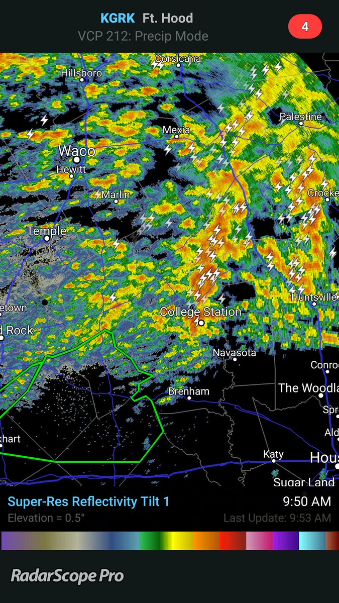
Looking like we may get a brief break after the storm that is in my turf in Eastern Harris County goes away. Development in Fort Bend county seems to be getting calmer and right now is reduced to nothing more than light showers. Should definitely not keep guard down at all today, however.
A transplant from Houston to Lincoln, Nebraska.
-
Ounce
- Posts: 470
- Joined: Sat Apr 17, 2010 10:18 pm
- Location: Houston
- Contact:
So, how much does the atmosphere being wrung out from the last 24 hours factor in to the rain, later today?
-
don

- Posts: 3148
- Joined: Wed Feb 03, 2010 3:33 pm
- Location: Wichita Falls
- Contact:
Latest HRRR show's another MCS moving through later today...
-
unome
- Posts: 3062
- Joined: Fri Feb 12, 2010 6:11 pm
https://twitter.com/femaregion6
http://www.fema.gov/news-release/2016/0 ... r-counties
FEMA Offers Advice for Texans on Lessening Storm Damage in Harris and Waller Counties
Release date: May 26, 2016
Release Number: NR026
– In Harris County, at Lowe’s in Houston and The Home Depot in Baytown; ACE Hardware in Waller (Waller County)
AUSTIN, Texas – A team of specialists from FEMA will visit Lowe’s and The Home Depot in Harris County and ACE Hardware in Waller County to offer tips and techniques to lessen the impact of disaster-related property damage.
Specialists will be available at the following locations:
Where: Lowe’s, 4645 Beechnut St., Houston, Texas 77096
Hours: 7 a.m. to 5:30 p.m. Thursday, Friday, Saturday May 26-28
7 a.m. to 5:30 p.m. Tuesday, May 31
Where: The Home Depot, 4915 Garth Rd., Baytown, Texas 77521
Hours: 7 a.m. to 5:30 p.m. Thursday, Friday, Saturday May 26-28
7 a.m. to 5:30 p.m. Tuesday, May 31
Where: Ace Hardware, 2906 Hwy. 290, Waller, Texas 77484
Hours: 7:30 a.m. to 6 p.m. Thursday, Friday May 26-27
8 a.m. to 4 p.m. Saturday, May 28
7:30 a.m. to 6 p.m. Tuesday, May 31
FEMA Mitigation specialists will be on hand to answer questions and offer home improvement tips to reduce damage in future disasters. Information is geared to both do-it-yourselfers and general contractors on topics such as storm shelters and safe rooms.
Booklets are available in English and Spanish on protecting your home from flood damage and other natural disasters. Survivors who need an accommodation to access Braille or large print can let FEMA representatives know. American Sign Language interpreters can be made available, if requested, by calling Everett Sedgwick at 202-870-4129. More information on how to strengthen homes, businesses and communities can be found at fema.gov/what-mitigation and fema.gov/texas-disaster-mitigation .
FEMA’s National Flood Insurance Program has a call center to answer policyholder questions, service claims, provide general information and offer technical assistance. To speak with a flood insurance specialist, call 800-621-3362 (FEMA), select option 2, between 8 a.m. and 6 p.m. Monday through Friday.
Texans can register online at http://www.DisasterAssistance.gov or by phone at 800-621-3362 (FEMA). Persons who are deaf, hard of hearing or have a speech disability and use a TTY may call 800-462-7585. Applicants who use 711 or Video Relay Service may also call 800-621-3362. The toll-free numbers are open from 7 a.m. to 10 p.m., seven days a week. Multilingual operators are available.
FEMA grants do not have to be repaid. FEMA assistance is nontaxable and will not affect eligibility for Social Security, Medicaid or other federal benefits.
Survivors should register even if they have insurance. FEMA cannot duplicate insurance payments, but underinsured applicants may receive help after their claims are settled.
For more information on the Texas recovery, visit the disaster webpage for the April storms at fema.gov/disaster/4269 ; or visit the Texas Division of Emergency Management website at txdps.state.tx.us/dem . Follow us on Twitter @femaregion6 .
Download the FEMA fema.gov/mobile-app to locate open shelters and disaster recovery centers, receive severe weather alerts, safety tips and much more.
-
unome
- Posts: 3062
- Joined: Fri Feb 12, 2010 6:11 pm
large gyre - high res, lrg loop: http://radar.weather.gov/Conus/full_loop.phpAndrew wrote:Starting to see more heavy rain move into the northern counties of SE Texas. Have to keep a close eye on how far west it builds.

-
Katdaddy

- Global Moderator

- Posts: 2521
- Joined: Thu Feb 04, 2010 8:18 am
- Location: League City, Tx
- Contact:
THE NATIONAL WEATHER SERVICE IN LEAGUE CITY HAS ISSUED A
* FLOOD WARNING FOR...
SOUTHEASTERN BURLESON COUNTY IN SOUTHEASTERN TEXAS...
WASHINGTON COUNTY IN SOUTHEASTERN TEXAS...
NORTHERN WALLER COUNTY IN SOUTHEASTERN TEXAS...
SOUTHERN GRIMES COUNTY IN SOUTHEASTERN TEXAS...
SOUTHEASTERN BRAZOS COUNTY IN SOUTHEASTERN TEXAS...
SOUTHWESTERN MONTGOMERY COUNTY IN SOUTHEASTERN TEXAS...
NORTHWESTERN HARRIS COUNTY IN SOUTHEASTERN TEXAS...
NORTHWESTERN AUSTIN COUNTY IN SOUTHEASTERN TEXAS...
* UNTIL 515 PM CDT FRIDAY
* AT 809 AM CDT...AREA FLOODING FROM VERY HEAVY RAINFALL TOTALING
BETWEEN 10 AND 20 INCHES THAT FELL FROM THURSDAY THROUGH EARLY
THIS MORNING CONTINUES TO SLOWLY RECEDE. ADDITIONAL SHOWER AND
THUNDERSTORM DEVELOPMENT IS STILL POSSIBLE TODAY...AND ANY
SIGNIFICANT RAIN FALLING ON ALREADY SATURATED GROUNDS WILL LIKELY
LEAD TO MORE FLOODING.
* SOME LOCATIONS THAT WILL EXPERIENCE FLOODING INCLUDE...
SOUTHERN COLLEGE STATION...BRENHAM...TOMBALL...NAVASOTA...HEMPSTEAD...
PRAIRIE VIEW...PINEHURST...THE WOODLANDS...WASHINGTON...SHELBY...WALLER...
MAGNOLIA...SOMERVILLE...PINE ISLAND...STAGECOACH...SNOOK...BURTON...
MILLICAN...ANDERSON AND TODD MISSION.
-
jasons2k

- Posts: 6192
- Joined: Thu Feb 04, 2010 12:54 pm
- Location: Imperial Oaks
- Contact:
You don't have to go far to hit the warm air. It's 68F in Conroe, but 80F at Hobby with strong south inflow...
-
djjordan

- Posts: 929
- Joined: Fri Feb 05, 2010 7:19 pm
- Location: Montgomery, Texas
- Contact:
Plenty of inflow here in Sugar Land as well with a South wind at 20 and near 80 Degrees with a Dewpoint of 74!!! Sticky!!!!!jasons wrote:You don't have to go far to hit the warm air. It's 68F in Conroe, but 80F at Hobby with strong south inflow...
~~~When Thunder Roars Go Indoors~~~
~~~Turn Around Don't Drown~~~
~~~Run From The Water, Hide From The Wind~~~
~~~Turn Around Don't Drown~~~
~~~Run From The Water, Hide From The Wind~~~
-
BlueJay
- Posts: 938
- Joined: Tue Mar 04, 2014 10:47 am
- Location: Alden Bridge-The Woodlands, Texas
- Contact:
Amazing weather coverage once again by this forum! Thanks gang!
-
unome
- Posts: 3062
- Joined: Fri Feb 12, 2010 6:11 pm
great reports on The Weather Channel (& others), probably been up all night - hope you get some rest today !
https://twitter.com/JeffLindner1/with_replies
https://twitter.com/JeffLindner1/with_replies
-
DoctorMu

- Posts: 8016
- Joined: Sun Jun 28, 2015 11:58 am
- Location: College Station
- Contact:
Yep. The sun + fuel from that slop will feed revival of potentially torrential rains today.djjordan wrote:Plenty of inflow here in Sugar Land as well with a South wind at 20 and near 80 Degrees with a Dewpoint of 74!!! Sticky!!!!!jasons wrote:You don't have to go far to hit the warm air. It's 68F in Conroe, but 80F at Hobby with strong south inflow...
-
DoctorMu
- Posts: 8016
- Joined: Sun Jun 28, 2015 11:58 am
- Location: College Station
- Contact:
8.38 inches total IMBY for the past 24 hours.Andrew wrote:Starting to see some of the same places get hit again. Bryan college station area has picked up another .30 inches.
-
DoctorMu
- Posts: 8016
- Joined: Sun Jun 28, 2015 11:58 am
- Location: College Station
- Contact:
Favorite tweet of the day:
Mack Morris @KBTXMack 35m35 minutes ago
Make it stop.
Mack Morris @KBTXMack 35m35 minutes ago
Make it stop.
-
srainhoutx

- Site Admin

- Posts: 19700
- Joined: Tue Feb 02, 2010 2:32 pm
- Location: Maggie Valley, NC
- Contact:
HGX just commented on the radar trends and the 12Z guidance. Their comment... "Ugh"
Carla/Alicia/Jerry(In The Eye)/Michelle/Charley/Ivan/Dennis/Katrina/Rita/Wilma/Humberto/Ike/Harvey
Member: National Weather Association
Facebook.com/Weather Infinity
Twitter @WeatherInfinity
Member: National Weather Association
Facebook.com/Weather Infinity
Twitter @WeatherInfinity
-
srainhoutx
- Site Admin
- Posts: 19700
- Joined: Tue Feb 02, 2010 2:32 pm
- Location: Maggie Valley, NC
- Contact:
Update from Jeff:
Radar trends becoming concerning again as strong forcing is approaching the area and showers and thunderstorms are developing over areas hard hit in the last 24-hrs.
Radar indicates rainfall rates increasing over the Brazos Valley region and shifting southward. An additional 1-3 inches of rainfall will be possible on top of what has already fallen and will only go to aggravate ongoing flooding issues across the region.
Will need to watch radar trends closely over the next several hours especially with any afternoon heating.
Note:
Brazos River at Hempstead at 2nd highest level ever recorded. Water has overtopped US 290 lanes. Highest level since 1913. Surpasses both the Oct 1994 and Dec 1991 floods.
Carla/Alicia/Jerry(In The Eye)/Michelle/Charley/Ivan/Dennis/Katrina/Rita/Wilma/Humberto/Ike/Harvey
Member: National Weather Association
Facebook.com/Weather Infinity
Twitter @WeatherInfinity
Member: National Weather Association
Facebook.com/Weather Infinity
Twitter @WeatherInfinity
-
srainhoutx
- Site Admin
- Posts: 19700
- Joined: Tue Feb 02, 2010 2:32 pm
- Location: Maggie Valley, NC
- Contact:
1500 UTC UPDATE
CENTRAL TO SOUTHEAST TX INTO THE LOWER MS VALLEY
SOME SIGNIFICANT CHANGES MADE TO THE PREVIOUS EXCESSIVE RAINFALL
POTENTIAL OUTLOOK FOR THE DAY 1 TIME PERIOD. THE BROAD RISK AREA
WAS SEPARATED INTO TWO AREAS AS PER LATEST RADAR TRENDS AND HI RES
SHORT TERM GUIDANCE. THE SOUTHERN RISK AREA WAS EXPANDED WESTWARD
INTO CENTRAL TX TO ACCOUNT FOR CONVECTION THAT CONTINUES TO FOCUS
ALONG AND JUST NORTH OF A WELL DEFINED OUTFLOW BOUNDARY OVER
CENTRAL TO SOUTHEAST TX. MOIST SOUTH SOUTHWESTERLY LOW LEVEL FLOW
INTO THIS BOUNDARY WILL CONTINUE TO SUPPORT POTENTIAL FOR
CONVECTION TO REFORM ON THE WESTERN PORTION OF THE OUTFLOW AND
TRAIN DOWNSTREAM. THIS MAY LIMIT THE NORTHWARD PUSH OF
PRECIP---WITH THIS THE PRIMARY REASON THE THREAT AREA WAS SPLIT
INTO TWO AREAS. THE HRR---HRRP AND HRRR EXPERIMENTAL SEEM TO HAVE
THE BEST HANDLE ON THIS CURRENT ACTIVITY---ALL SUGGESTING THE
HEAVY RAIN THREAT WILL CONTINUE INTO THIS AFTERNOON ALONG AND
NORTH OF THIS BOUNDARY---BUT REMAIN CENTERED FARTHER TO THE SOUTH
THAN SOME OF THE OTHER GUIDANCE IS SHOWING. TOWARD THE END OF
THIS FORECAST PERIOD---EARLY MORNING HOURS OF
SATURDAY---CONVECTION MAY PUSH SOUTHWARD BACK INTO AREAS WHERE THE
FFG VALUES HAVE LOWERED SIGNIFICANTLY OVER SOUTHEAST TX. FOR THIS
REASON---THE PREVIOUS MODERATE RISK AREA WAS PUSHED SOUTHWARD AND
ANOTHER MODERATE AREA WAS ADDED BETWEEN WACO AND BROWNWOOD FOR
CURRENT ACTIVITY AND LOW FFG VALUES.
Carla/Alicia/Jerry(In The Eye)/Michelle/Charley/Ivan/Dennis/Katrina/Rita/Wilma/Humberto/Ike/Harvey
Member: National Weather Association
Facebook.com/Weather Infinity
Twitter @WeatherInfinity
Member: National Weather Association
Facebook.com/Weather Infinity
Twitter @WeatherInfinity