

April 2016 Recap: Regional Flood/Severe Weather
-
DoctorMu

- Posts: 7910
- Joined: Sun Jun 28, 2015 11:58 am
- Location: College Station
- Contact:
Bastrop and Madisonville win the Hotspot awards for today with totals exceeding a foot of rain.
-
DoctorMu
- Posts: 7910
- Joined: Sun Jun 28, 2015 11:58 am
- Location: College Station
- Contact:
A line between Bastrop and Rockdale getting nailed. It could be worse for urban areas currently. Many more chapters to be written as the low slows forward movement.

-
unome
- Posts: 3062
- Joined: Fri Feb 12, 2010 6:11 pm
from https://weather.im/iembot/DoctorMu wrote:A line between Bastrop and Rockdale getting nailed. It could be worse for urban areas currently. Many more chapters to be written as the low slows forward movement.
3 W CIRCL D-KC ESTAT
Time: 2016-04-17T18:38:00Z UTC
Event: 5.92 HEAVY RAIN
Source: MESONET
Remark: RAINFALL IN THE PAST 3 HOURS
and
168
WWUS84 KEWX 171859
SPSEWX
SPECIAL WEATHER STATEMENT
NATIONAL WEATHER SERVICE AUSTIN/SAN ANTONIO TX
159 PM CDT SUN APR 17 2016
TXZ185-187-203-171945-
BANDERA TX-REAL TX-UVALDE TX-
159 PM CDT SUN APR 17 2016
...SIGNIFICANT WEATHER ADVISORY FOR NORTH CENTRAL UVALDE...
SOUTHWESTERN BANDERA AND SOUTHEASTERN REAL COUNTIES UNTIL 245 PM CDT...
AT 158 PM CDT...DOPPLER RADAR WAS TRACKING A STRONG THUNDERSTORM OVER GARNER STATE PARK...OR 10 MILES SOUTH OF LEAKEY...MOVING NORTHEAST AT 20 MPH.
NICKEL SIZE HAIL AND WINDS IN EXCESS OF 40 MPH WILL BE POSSIBLE WITH THIS STORM.
LOCATIONS IMPACTED INCLUDE...
LEAKEY...VANDERPOOL...CONCAN...GARNER STATE PARK...UTOPIA...LOST MAPLES STATE PARK AND RIO FRIO.
PRECAUTIONARY/PREPAREDNESS ACTIONS...
FREQUENT CLOUD TO GROUND LIGHTNING IS OCCURRING WITH THIS STORM.
LIGHTNING CAN STRIKE 10 MILES AWAY FROM A THUNDERSTORM. SEEK A SAFE SHELTER INSIDE A BUILDING OR VEHICLE.
THIS STORM MAY INTENSIFY...SO BE CERTAIN TO MONITOR LOCAL RADIO AND TV STATIONS...AS WELL AS LOCAL CABLE TV OUTLETS...FOR ADDITIONAL INFORMATION AND POSSIBLE WARNINGS FROM THE NATIONAL WEATHER SERVICE.
&&
LAT...LON 2945 9972 2963 9985 2990 9960 2967 9936
TIME...MOT...LOC 1858Z 228DEG 16KT 2958 9973
$$
LJH
-
unome
- Posts: 3062
- Joined: Fri Feb 12, 2010 6:11 pm
-
Cromagnum
- Posts: 3060
- Joined: Thu Feb 03, 2011 10:42 pm
- Location: Georgetown
- Contact:
Looking more and more like southern Harris county and brazoria county wont see anything from this. Send all the rain down here, we need it.
-
unome
- Posts: 3062
- Joined: Fri Feb 12, 2010 6:11 pm
250 pm edt sun apr 17 2016
prelim day 1 qpf discussion
valid apr 18/0000 utc thru apr 19/0000 utc
reference awips graphics under...precip accum - 24hr
southern plains
there is a strong model signal for heavy to excessive rainfall amounts this period over east to southeast tx to the southeast of the slow moving frontal boundary across the central to southern plains. model skill recently has been very poor with respect to the details... and has generally been too heavy to far to the west in the vicinity of this front. organized convection this afternoon is focusing farther to the southeast of this front from eastern portions of tx in the vicinity of the ewx.. fwd wfos.. northeastward into eastern ok. moist southerly inflow into the well defined outflow from the east central tx convection is helping to rebuild convection on the south side of the precip area..with training then in a south to north direction. while confidence is low with details... especially given how poor models have been recently with current activity... the day 1 qpf leaned toward the hi res arw and cmc gem for the details over southeast tx... which supports a slow east southeast movement of organized convection. while the details model to model differ... there is a strong signal for very to excessive amounts over southeast tx. day 1 amounts are depicted in the 5-7" range--- with potentially for locally heavier totals depending on how the mesoscale details evolve. there has been a tremendous amount of variability in the hi res guidance run to run in how quickly this organized convection will press downstream... adding to the overall low confidence. however---at the moment the timing of the hi res arw/cmc gem was used more for details. significant flash flooding possible across the max precip area. the update to the excessive rainfall potential outlook reflects this with an upgrade to high centered on the max axis from the ewd--- eastern fwd and western hgx cwas.
less precip was favored northward of this max southeast tx area across ok... ks and ne. this is especially so closer to the synoptic frontal boundary which is lying farther to the west than the outflow boundary. belief at the moment is that the heaviest precip here will be over eastern ok closer to the current axis. models have shown a lot of variability with respect to whether precip will enhance along the synoptic front. while we do not favor significant precip along the immediate front... there are still uncertainties in how heavy precip will be over eastern ok where the current precip axis is. this precip area will likely be slow moving which could support heavy amounts. concerns are for disruptions to precip here to the north of what is expected to remain organized convection pressing slowly east southeastward into southeast tx.
farther northward into the northern plains--- a developing surface wave monday morning moving northward along the slow moving front will support a northern comma head/deformation precip axis from far southeast mt... far northeast wy into sd... southern nd and into eastern ne and western ia. the latest ecmwf trended faster to the northeast here and is closer to the nam/gfs consensus with the qpf axis. moderate to heavy precip totals of .50-1"+ possible across these areas.
graphics available on the web at http://www.wpc.ncep.noaa.gov/qpf/qpf2.shtml
oravec
Last edited by unome on Fri Apr 22, 2016 7:09 am, edited 1 time in total.
-
srainhoutx

- Site Admin

- Posts: 19700
- Joined: Tue Feb 02, 2010 2:32 pm
- Location: Maggie Valley, NC
- Contact:
WPC issues High Risk for Excessive Rainfall across the Hill Country. Beginning to see storms develop near Alice and seeing towers popping near Harlingen while waiting on my flight home.
- Attachments
-
Carla/Alicia/Jerry(In The Eye)/Michelle/Charley/Ivan/Dennis/Katrina/Rita/Wilma/Humberto/Ike/Harvey
Member: National Weather Association
Facebook.com/Weather Infinity
Twitter @WeatherInfinity
Member: National Weather Association
Facebook.com/Weather Infinity
Twitter @WeatherInfinity
-
unome
- Posts: 3062
- Joined: Fri Feb 12, 2010 6:11 pm
http://www.wpc.ncep.noaa.gov/discussion ... isc=qpferd
excessive rainfall discussion
nws weather prediction center college park md
259 pm edt sun apr 17 2016
...valid 21z sun apr 17 2016 - 12z mon apr 18 2016...
...reference awips graphic under...day 1 excessive rainfall...
slight risk of rainfall exceeding ffg to the right of a line from 30 wsw mwt 35 e och hou 10 se vct 40 wsw cot 20 n mmpg 15 nne jct 35 wnw chk rsl 10 ene hde 25 nnw gri 20 se jyr 15 nne emp 15 nnw tqh 20 ese rkr 30 wsw mwt.
moderate risk of rainfall exceeding ffg to the right of a line from 20 nnw 6r9 25 sse sep gky 10 sse trl 20 wsw tyr 15 sse psn uts 20 nw dwh 30 s 11r 40 se baz 10 s hdo 30 wsw erv 25 se jct 20 nnw 6r9.
1900 utc update
additional changes were made to the day 1 excessive rainfall potential outlook given current convective trends and latest hi res data. biggest concern this period are for the evolution to the convection currently stretching from eastern portions of ewx wfo...extending into the central to eastern fwd area. there is a strong model signal for heavy to excessive rainfall amounts this period over east to southeast tx to the southeast of the slow moving frontal boundary across the central to southern plains. model skill recently has been very poor with respect to the details...and has generally been too heavy to far to the west in the vicinity of this front. moist southerly inflow into the well defined outflow from the east central tx convection is helping to rebuild convection on the south side of the precip area..with training then in a south to north direction. while confidence is low with details...especially given how poor models have been recently with current activity...the day 1 qpf leaned toward the hi res arw and cmc gem for the details over southeast tx...which supports a slow east southeast movement of organized convection. while the details model to model differ...there is a strong signal for very heavy to excessive amounts over southeast tx. day 1 amounts are depicted in the 5-7" range---with potentially for locally heavier totals depending on how the mesoscale details evolve. there has been a tremendous amount of variability in the hi res guidance run to run in how quickly this organized convection will press downstream...adding to the overall low confidence. however---at the moment the timing of the hi res arw/cmc gem was used more for details. significant flash flooding possible across the max precip area. the update to the excessive rainfall potential outlook reflects this with an upgrade to high centered on the max axis from the ewd---eastern fwd and western hgx cwas. please see wpcs mesoscale precipitation discussion #0123 valid until 2315 utc for additional information across the moderate and high risk area depicted on the day 1 outlook. northward into eastern ok...a slight risk area was maintained as current precip is slow moving here and some training potential continues. still uncertainties how the expected active convection farther south will disrupt this activity. generally---models have been too wet northward along and east of this boundary---especially closer to the front itself.
oravec
Last edited by unome on Sun Apr 17, 2016 3:36 pm, edited 1 time in total.
-
unome
- Posts: 3062
- Joined: Fri Feb 12, 2010 6:11 pm

mesoscale discussion 0406
nws storm prediction center norman ok
0247 pm cdt sun apr 17 2016
areas affected...south central texas
concerning...severe potential...watch possible
valid 171947z - 172115z
probability of watch issuance...40 percent
summary...scattered thunderstorms will concentrate across south central texas over the next few hours. isolated large hail and perhaps a brief tornado can be expected.
discussion... nwwd-moving outflow with a band of convection is propagating into the i-35 corridor between aus and sat attm. farther north... larger precip shield over central tx is generating swd-moving wind shift that should interact with this activity and could enhance convective potential invof the balcones escarpment. latest mrms data suggests marginally severe hail has accompanied storm that lifted across uvalde into bandera county. shear profiles favor deep rotating updrafts and various outflow boundaries/interactions could locally aid brief tornado activity. will continue to monitor this convection for possible ww.
..darrow/hart.. 04/17/2016
attn...wfo...hgx...fwd...crp...ewx...
lat...lon 29839961 30669799 30659683 30029745 28489833 28639939 29839961
Last edited by unome on Sun Apr 17, 2016 3:12 pm, edited 1 time in total.
-
srainhoutx
- Site Admin
- Posts: 19700
- Joined: Tue Feb 02, 2010 2:32 pm
- Location: Maggie Valley, NC
- Contact:
Update from Jeff:
Excessive rainfall and flash flood event underway across C TX.
Potentially dangerous flash flood event next several hours from Austin to San Marcos to College Station to Columbus.
Strong low level inflow colliding with slow moving outflow boundary resulting in rapid increase in tremendous rainfall rates along and W of I-35 from south of Waco to west of Austin. Period of cell training over Bastrop County resulted in 1-hr rainfall of 4.09 inches and 1.5 hours of over 6 inches. High resolution models show extensive training of excessive rainfall along a corridor from San Marcos to Austin to south of Waco over the next 6-8 hours with an additional 6 inches likely on top of what has fallen. Flash flooding will result from this magnitude of rainfall.
Models have not been handling the placement of the meso boundaries well at all and this leaves much to be desired into tonight on forecast confidence. Appears large slow moving MCS will push slowly into SE TX this evening with excessive rainfall from College Station to Columbus. Think this corridor is going to get hit pretty hard based on what has happened over Bastrop County some very impressive totals are possible tonight. Should bring all this toward the US 59 corridor mid to late morning, but how fast it moves is a big question and will greatly determine the overall flash flood threat for those US 59 counties.
Carla/Alicia/Jerry(In The Eye)/Michelle/Charley/Ivan/Dennis/Katrina/Rita/Wilma/Humberto/Ike/Harvey
Member: National Weather Association
Facebook.com/Weather Infinity
Twitter @WeatherInfinity
Member: National Weather Association
Facebook.com/Weather Infinity
Twitter @WeatherInfinity
-
Katdaddy

- Global Moderator

- Posts: 2521
- Joined: Thu Feb 04, 2010 8:18 am
- Location: League City, Tx
- Contact:
The Houston-Galveston NWS has expanded the Flash Flood Watch issued earlier to include entire county warning area which includes the Houston-Galveston areas.
...FLASH FLOOD WATCH IN EFFECT THROUGH TUESDAY MORNING...
THE NATIONAL WEATHER SERVICE IN HOUSTON/GALVESTON HAS EXPANDED
THE
* FLASH FLOOD WATCH TO INCLUDE A PORTION OF SOUTHEAST TEXAS...
INCLUDING THE FOLLOWING BRAZORIA...CHAMBERS...FORT ...BEND...
GALVESTON...HARRIS...JACKSON...LIBERTY...MATAGORDA...
MONTGOMERY...POLK...SAN JACINTO...TRINITY...WALKER...WALLER
AND WHARTON.
* THROUGH TUESDAY MORNING
* THUNDERSTORMS ARE EXPECTED TO DEVELOP AND MOVE INTO THE WATCH
AREA FROM CENTRAL TEXAS. SOME OF THESE STORMS WILL BE CAPABLE OF
VERY HEAVY RAINFALL WHICH MAY PRODUCING FLASH FLOODING. SOME
STORMS MAY MOVE OVER SOME OF THE SAME AREAS THAT RECEIVED HEAVY
RAINFALL WHICH WILL ONLY PROLONG THE THREAT FOR FLASH FLOODING.
THE GREATEST THREAT FOR FLASH FLOODING APPEARS TO BE FROM
COLLEGE STATION TO CROCKETT TONIGHT INTO MONDAY MORNING. ANOTHER
ROUND OF STORMS COULD AFFECT THE SAME AREA MONDAY NIGHT INTO
TUESDAY. THE THREAT FOR FLOODING MAY EXPAND DURING THIS TIME TO
INCLUDE THE HOUSTON AREA AND GULF COAST. THREE DAY RAINFALL
AMOUNTS FROM TODAY THROUGH TUESDAY ARE EXPECTED TO BE AROUND 3
TO 5 INCHES ACROSS THE AREA WITH ISOLATED AMOUNTS OF GREATER
THAN 8 INCHES.
* FLOODING IMPACTS ARE EXPECTED TO BE FLOODING OF LOW LYING
ROADS AND LOW WATER CROSSINGS. EXPECT RAPID INCREASES ON AREA
RIVERS AND CREEKS. PROLONGED RIVER FLOODING COULD RESULT FROM
RUNOFF OF THE EXCESSIVE RAINFALL.
PRECAUTIONARY/PREPAREDNESS ACTIONS...
A FLASH FLOOD WATCH MEANS THAT CONDITIONS MAY DEVELOP THAT LEAD
TO FLASH FLOODING. FLASH FLOODING IS A VERY DANGEROUS SITUATION.
YOU SHOULD MONITOR LATER FORECASTS AND BE PREPARED TO TAKE ACTION
SHOULD FLASH FLOOD WARNINGS BE ISSUED.
- Attachments
-
- Screen Shot 2016-04-17 at 3.45.34 PM.png (39.01 KiB) Viewed 5587 times
-
unome
- Posts: 3062
- Joined: Fri Feb 12, 2010 6:11 pm
pretty impressive radar building over San Antonio
http://weather.cod.edu/satrad/nexrad/in ... X-N0Q-1-48
http://weather.cod.edu/satrad/nexrad/in ... X-N0Q-1-48
Last edited by unome on Fri Apr 22, 2016 7:08 am, edited 1 time in total.
-
unome
- Posts: 3062
- Joined: Fri Feb 12, 2010 6:11 pm
great video shared by NWS San Antonio/Austin - if you are thinking about driving through flooded roads, please watch this - I guarantee it will make you think again
https://youtu.be/tYBo6t4_6_U
Published on Oct 9, 2015
Austin’s roads can flood in a flash! On October 12, 2013, an intense storm flooded parts of the Austin area with over a foot of rain. That night, Commander Jim Martin, a paramedic with the City of Austin, was on his way to work when he became a victim of flash flooding. This video shows firsthand the dangers of being swept away in a flash flood. Visit https://atxfloods.com for real-time information on flooded roads in Austin.
-
Andrew
- Site Admin
- Posts: 3508
- Joined: Wed Feb 03, 2010 9:46 pm
- Location: North-West Houston
- Contact:
Looks like the setup has been further west than anticipated so far today. That will slowly shift east overnight and tomorrow but i do suspect areas along the i35 corridor will be some of our larger totals. Where the MCS(s) form and tracks tonight and tomorrow will be also see large totals. Expect a large gradient though as you move away from the MCS.
For Your Infinite Source For All Things Weather Visit Our Facebook
-
jasons2k

- Posts: 6166
- Joined: Thu Feb 04, 2010 12:54 pm
- Location: Imperial Oaks
- Contact:
GFS now has the greatest totals in two areas, one from Montgomery County into San Jacinto County, and the other along the coast in Matagorda County. Like others have said, the global models are pretty much pointless to pinpoint exact locations, but the common theme is a heavy 15"+ somewhere, and it keeps skipping around from run-to-run.
-
Andrew
- Site Admin
- Posts: 3508
- Joined: Wed Feb 03, 2010 9:46 pm
- Location: North-West Houston
- Contact:
-
TexasBreeze
- Posts: 1024
- Joined: Sun Sep 26, 2010 4:46 pm
- Location: NW Houston, TX
- Contact:
There's streamer showers developing around Harris County. We will see if they start building up and training possibly later...
-
unome
- Posts: 3062
- Joined: Fri Feb 12, 2010 6:11 pm
http://www.wpc.ncep.noaa.gov/archives/m ... e=20160417
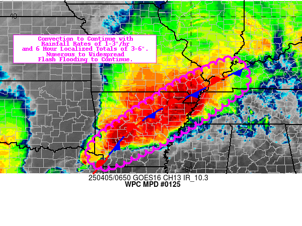
mesoscale precipitation discussion 0125
nws weather prediction center college park md
746 pm edt sun apr 17 2016
areas affected... cntrl texas
concerning... heavy rainfall... flash flooding likely
valid 172345z - 180545z
summary... very heavy rain is expected north of an outflow boundary located across cntrl texas with hourly rates of 2+ in/hr through 05z. also watching potential for the development of an axis of flash flooding rain along the cntrl texas coast by 03z.
discussion...23z observations placed a quasi-stationary outflow boundary across cntrl texas... sw to ne... from near hdo to aus to jdd. a wwd surging outflow located south of this boundary was observed to intersect the nearly stationary outflow boundary just west of hdo. low level flow continues to overrun the quasi-stationary boundary producing flash flooding rainfall over williamson... bell... falls and milam counties. 850 mb vad wind plots showed 30-40 kts from the southeast and gps precipitable water values were between 1.6 - 1.8 inches across a broad swatch of cntrl-ern texas. while instability has likely waned somewhat compared to earlier in the day as surface temperatures begin to cool... anywhere from 500-1500 j/kg ml cape remains along i-10 between san antonio and houston.
rap/gfs forecasts have been consistent in showing an uptick in low level wind/moisture transport across the cntrl texas coast into and over the quasi-stationary outflow boundary in cntrl texas. given instability and upper diffluence is expected to linger into the early overnight hours...continued training of heavy rain is expected in the vicinity of i-35 in cntrl texas with additional rainfall totals of 3-5 inches possible.
also of note... the 22z hrrr has introduced an axis of very heavy rain... which may be in the beginning stages... between galveston and matagorda bay...as a zone of greater low level flow/total precipitable water overruns relatively cooler air located in the w-cntrl gulf at the base of surface ridging. confidence in flash flooding is lower across the coastal plain... and higher in the vicinity of the outflow boundary in cntrl texas.
otto
...please see http://www.wpc.ncep.noaa.gov for graphic product...
attn...wfo...crp...ewx...fwd...hgx...sjt...
-
srainhoutx
- Site Admin
- Posts: 19700
- Joined: Tue Feb 02, 2010 2:32 pm
- Location: Maggie Valley, NC
- Contact:
Update from Jeff:
Unexpected SE to NW training bands of showers and thunderstorms developing over SE TX. Not until the last hour did any meso model show this and radar is rapidly filling in west of I-45. Lightning data showing strikes indicating storms are becoming organized.
Will have to watch this trend very closely next few hours. HRRR 22Z run shows extensive development over the next 2-3 hours between Matagorda Bay and Galveston Bay training NW and this was recently mentioned in excessive rainfall outlook from WPC (see image above posted by unome). Focus appears to be a surge of tropical moisture, with no low level boundary. Major flash flood event undfolding along/east of I-35 in red circled area with excessive rainfall under training cells. Rainfall rates upwards of 3.0 inches per hour with these storms. These storms have become very organized and will begin to slowly shift SE with time.
Carla/Alicia/Jerry(In The Eye)/Michelle/Charley/Ivan/Dennis/Katrina/Rita/Wilma/Humberto/Ike/Harvey
Member: National Weather Association
Facebook.com/Weather Infinity
Twitter @WeatherInfinity
Member: National Weather Association
Facebook.com/Weather Infinity
Twitter @WeatherInfinity