
2015 Hurricane Season Outlook
-
brooksgarner

- Global Moderator

- Posts: 226
- Joined: Tue Jun 04, 2013 3:06 pm
- Location: Houston, TX
- Contact:
Maybe... maybe. Sure is early. This is the GFS...
Broadcast Met
http://BrooksGarner.com
http://twitter.com/BrooksWeather
http://BrooksGarner.com
http://twitter.com/BrooksWeather
- '17 Harvey
- '12 Sandy (P3 Orion)
- '91 Bob
- '85 Gloria
-
srainhoutx

- Site Admin

- Posts: 19700
- Joined: Tue Feb 02, 2010 2:32 pm
- Location: Maggie Valley, NC
- Contact:
Be sure to check out the Hurricane Central area of our Regional Forum when tropical troubles are not brewing along the Gulf Coast.
http://forums.khou.com/viewforum.php?f=4
http://forums.khou.com/viewforum.php?f=4
Carla/Alicia/Jerry(In The Eye)/Michelle/Charley/Ivan/Dennis/Katrina/Rita/Wilma/Humberto/Ike/Harvey
Member: National Weather Association
Facebook.com/Weather Infinity
Twitter @WeatherInfinity
Member: National Weather Association
Facebook.com/Weather Infinity
Twitter @WeatherInfinity
-
Texaspirate11

- Posts: 1278
- Joined: Tue Dec 31, 2013 12:24 am
- Contact:
In 2012 we had two "early" storms. And a quiet cane seasonbrooksgarner wrote:Maybe... maybe. Sure is early. This is the GFS...
Just because you're disabled, you don't have to be a victim
Be Weather Aware & Prepared!
Barbara Jordan Winner in Media
Disability Integration Consultant
Be Weather Aware & Prepared!
Barbara Jordan Winner in Media
Disability Integration Consultant
-
srainhoutx
- Site Admin
- Posts: 19700
- Joined: Tue Feb 02, 2010 2:32 pm
- Location: Maggie Valley, NC
- Contact:
National Hurricane Preparedness Week 2015 will be May 24th through May 30th. In the link below you can find a lot of information including Youtube videos in English and Spanish. Now is the time to Prepare!
http://www.nhc.noaa.gov/prepare/
http://www.nhc.noaa.gov/prepare/
Carla/Alicia/Jerry(In The Eye)/Michelle/Charley/Ivan/Dennis/Katrina/Rita/Wilma/Humberto/Ike/Harvey
Member: National Weather Association
Facebook.com/Weather Infinity
Twitter @WeatherInfinity
Member: National Weather Association
Facebook.com/Weather Infinity
Twitter @WeatherInfinity
-
srainhoutx
- Site Admin
- Posts: 19700
- Joined: Tue Feb 02, 2010 2:32 pm
- Location: Maggie Valley, NC
- Contact:
NOAA releases their 2015 NALT Hurricane Outlook.
http://www.noaanews.noaa.gov/stories201 ... -year.html
http://www.noaanews.noaa.gov/stories201 ... -year.html
Carla/Alicia/Jerry(In The Eye)/Michelle/Charley/Ivan/Dennis/Katrina/Rita/Wilma/Humberto/Ike/Harvey
Member: National Weather Association
Facebook.com/Weather Infinity
Twitter @WeatherInfinity
Member: National Weather Association
Facebook.com/Weather Infinity
Twitter @WeatherInfinity
-
srainhoutx
- Site Admin
- Posts: 19700
- Joined: Tue Feb 02, 2010 2:32 pm
- Location: Maggie Valley, NC
- Contact:
Do you and your family have a plan?
- Attachments
-
Carla/Alicia/Jerry(In The Eye)/Michelle/Charley/Ivan/Dennis/Katrina/Rita/Wilma/Humberto/Ike/Harvey
Member: National Weather Association
Facebook.com/Weather Infinity
Twitter @WeatherInfinity
Member: National Weather Association
Facebook.com/Weather Infinity
Twitter @WeatherInfinity
-
unome
- Posts: 3062
- Joined: Fri Feb 12, 2010 6:11 pm
Jim Williams, http://www.hurricanecity.com , had his '15 kick-off show last night, recorded here:
love all the improvements on his site this year, Chris at Tropical Atlantic has done a lot of work with him as well
love all the improvements on his site this year, Chris at Tropical Atlantic has done a lot of work with him as well
-
srainhoutx
- Site Admin
- Posts: 19700
- Joined: Tue Feb 02, 2010 2:32 pm
- Location: Maggie Valley, NC
- Contact:
From NWS Houston/Galveston in a continuing effort to educate folks about storm surge and the new data and advisories we will see this season.
Storm Surge is the abnormal rise of water generated by a storm’s winds. This hazard is historically the leading cause of deaths in the United States in hurricanes. The destructive power of storm surge and large battering waves can result in large loss of life and destruction along the coast. Storm surge can travel several miles inland, especially along bays, rivers, and estuaries. Watch this video to learn about storm surge and how to stay safe!
http://bit.ly/1BdIXLi #HurricanePrep #ItOnlyTakesOne
https://www.youtube.com/watch?feature=p ... Ba9bVYKLP0
Carla/Alicia/Jerry(In The Eye)/Michelle/Charley/Ivan/Dennis/Katrina/Rita/Wilma/Humberto/Ike/Harvey
Member: National Weather Association
Facebook.com/Weather Infinity
Twitter @WeatherInfinity
Member: National Weather Association
Facebook.com/Weather Infinity
Twitter @WeatherInfinity
-
unome
- Posts: 3062
- Joined: Fri Feb 12, 2010 6:11 pm
NHC Products and Services for 2015: http://www.nhc.noaa.gov/news/20150326_p ... hanges.pdf
and, from their news release about the new storm surge watch/warning graphic, to be issued with a tropical storm: http://www.nhc.noaa.gov/news/20150318_p ... arning.pdf
The graphic will be experimental for at least two years, during which time comments from users will be solicited and considered. Only the graphic itself will be available during the experimental period; the underlying raw data, including shapefiles, will not be disseminated.
The new watch/warning graphic complements the experimental Potential Storm Surge Flooding Map,
which debuted during 2014’s Hurricane Arthur. The Potential Storm Surge Flooding Map shows the geographical areas where inundation from storm surge could occur and how high above ground the water could potentially reach in those areas, based on the latest official NHC forecast and its likely errors.
As part of a phased implementation , NHC plans to consolidate the dissemination of wind and surge watches and warnings in 2016. This new process will merge inland and coastal warning information for both threats into a single message. After incorporating both user and partner input, the new storm surge warning system is expected to become fully operational in 2017.
from their Prototype Storm Surge Watch & Warning Graphic - Tips for Media Professionals (PDF) available here: http://www.nhc.noaa.gov/surge/resources.php
Would it be an official NWS storm surge warning during the 2015 season?
No, it would not. The 2015 prototype storm surge watch/warning graphic is the first step of a phased implementation toward an NWS storm surge warning system;; it does not represent an official NWS warning. Like a warning, however, the graphic is intended to identify and help users visualize the areas most at risk from life-threatening surge, and serves as a call to action. It is also intended to stimulate initial feedback from users and partners by introducing the concept of a separate NWS warning for storm surge.
-
Paul Robison
Hate to bug y'all but, is this the start of something Houstonians will have to watch out for next week?
-
srainhoutx
- Site Admin
- Posts: 19700
- Joined: Tue Feb 02, 2010 2:32 pm
- Location: Maggie Valley, NC
- Contact:
The morning update regarding the timeframe we may see enhanced potential for tropical development in the Western Atlantic Basin would likely be around the mid July timeframe. A robust Westerly Wind Burst is traversing Eastbound across the Pacific Ocean and the 200 hPa Velocity Potential Anomalies which favor rising air across the tropics allowing for the development of organized tropical thunderstorms should reach the Eastern Pacific around the 1st week of July and progress into the Western Caribbean/Western Gulf around mid next month. As always, we cannot not accurately predict when and where any potential tropical systems may develop as well as whether the upper level winds may or may not be conducive for tropical development this far out. That said we can recognize approximately when conditions may be a bit more favorable for tropical development. Time will tell.
Carla/Alicia/Jerry(In The Eye)/Michelle/Charley/Ivan/Dennis/Katrina/Rita/Wilma/Humberto/Ike/Harvey
Member: National Weather Association
Facebook.com/Weather Infinity
Twitter @WeatherInfinity
Member: National Weather Association
Facebook.com/Weather Infinity
Twitter @WeatherInfinity
-
srainhoutx
- Site Admin
- Posts: 19700
- Joined: Tue Feb 02, 2010 2:32 pm
- Location: Maggie Valley, NC
- Contact:
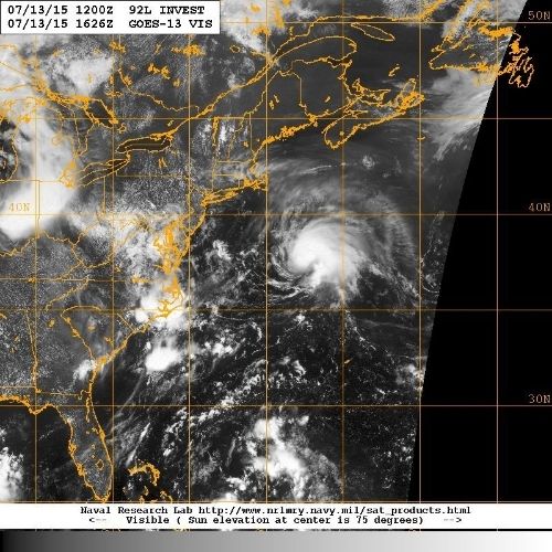
Tropical Storm Claudette has formed offshore of the NE Atlantic United States Coast.
SPECIAL TROPICAL WEATHER OUTLOOK
NWS NATIONAL HURRICANE CENTER MIAMI FL
1230 PM EDT MON JUL 13 2015
For the North Atlantic...Caribbean Sea and the Gulf of Mexico:
Special tropical weather outlook issued to update the discussion on
the low pressure system east of the United States mid-Atlantic
coast.
Satellite pictures indicate that shower and thunderstorm activity
associated with a low pressure system located about 450 miles east-
northeast of Cape Hatteras, North Carolina, continues to become
better organized. Satellite wind data also indicate that the low's
circulation is well defined, with winds of tropical storm force.
Based on these data, advisories on a tropical storm will be issued
within the next hour. The low is expected to accelerate
northeastward during the next day or two, away from the U.S. coast.
* Formation chance through 48 hours...high...near 100 percent
* Formation chance through 5 days...high...near 100 percent
$$
Forecaster Kimberlain/Brown
Carla/Alicia/Jerry(In The Eye)/Michelle/Charley/Ivan/Dennis/Katrina/Rita/Wilma/Humberto/Ike/Harvey
Member: National Weather Association
Facebook.com/Weather Infinity
Twitter @WeatherInfinity
Member: National Weather Association
Facebook.com/Weather Infinity
Twitter @WeatherInfinity
-
srainhoutx
- Site Admin
- Posts: 19700
- Joined: Tue Feb 02, 2010 2:32 pm
- Location: Maggie Valley, NC
- Contact:
Cyclones and Warnings and Names, Oh My!
by James Franklin

Visible satellite image of Tropical Storm Bill at 10:15 am CDT on Tuesday, June 16, just before it made landfall along the Texas coast on Matagorda Island.
The development of Tropical Storm Bill so close to the Texas coast, with the posting of a formal tropical storm warning only about 12 hours before winds of that intensity came ashore on Tuesday June 16th, highlighted a long-standing and well-known limitation in the tropical cyclone program of the National Weather Service (NWS). An ongoing NHC initiative to improve service for such systems is the subject of today’s blog post.
Although there’s nothing new about a tropical cyclone forming on our doorstep, what is new is an increased ability to anticipate it. NHC has greatly enhanced its forecasts of tropical cyclone formation over the past several years, introducing quantitative 48-hr genesis forecasts to the Tropical Weather Outlook in 2008, and extending those forecasts to 120 hours in 2013. In 2014, we introduced a graphic showing the locations of tropical disturbances and the areas where they could develop into a depression or storm over the subsequent five days. Thirty-six hours in advance of Bill’s formation, NHC gave the precursor disturbance a 60% chance of becoming a tropical cyclone, and increased that probability to 80% about 24 hours in advance. While nothing was guaranteed, we were pretty confident a tropical storm was going to form before the disturbance reached the coast. And although we weren’t issuing specific track forecasts for the disturbance, NHC’s new graphical Tropical Weather Outlook (example below) showed where the system was generally headed.
We wouldn't have had such confidence 20 years ago, or even 5 years ago. And so our tropical cyclone warning system, developed over several decades, doesn’t allow for a watch or warning until a depression or storm actually forms and NHC’s advisories begin; by both policy and software, warning issuances are tied to cyclone advisories. If we had wanted to issue a tropical storm watch for Bill on the morning of Sunday the 14th (48 hours prior to landfall), or a warning that evening (36 hours ahead of landfall), we would have had to pretend that the disturbance in the Gulf of Mexico was a tropical cyclone. Even during the day on Monday, data from an Air Force Reserve Hurricane Hunter aircraft showed that the disturbance had not yet become a depression or storm.
Couldn’t NHC have called the disturbance a tropical storm anyway, in the interest of enhanced preparedness? Yes, but what if the disturbance never becomes a tropical storm - remember, even an 80% chance of formation means it won’t become a tropical storm at least once every five times. So naming it early risks the credibility of the NWS and NHC, and endangers a trust we’ve worked for decades to establish. In addition, there are legal and financial consequences to an official designation of a tropical cyclone - consequences that obligate us to call it straight. And finally, as custodians of the tropical cyclone historical record, we have a responsibility to ensure the integrity of that record.
When systems that have the potential to become tropical cyclones pose hazards to life and property, NHC’s best avenue for highlighting those hazards currently is the Tropical Weather Outlook. Ahead of Bill’s formation, the possibility of tropical storm conditions along the middle and upper Texas coast was included in the Sunday evening Outlook, and by early Monday afternoon the Outlooks were saying those conditions were likely. Products issued by NWS local forecast offices (WFOs) carried similar statements.
Although most folks seemed to have gotten the message that a tropical storm was coming, it’s widely thought that the Tropical Weather Outlook and local WFO products don’t carry the visibility and weight of an NHC warning, or of an NHC advisory package with its attendant graphics. In addition, some institutions have preparedness plans that are tied to the presence of warnings. We agree that warnings during the disturbance stage could improve community response, and we’ve been working toward that goal since 2011. In that season, NHC initiated an internal experiment in which the Hurricane Specialists prepare track and intensity forecasts for disturbances with a high likelihood of development, and use these forecasts to determine where watches and warnings would have been appropriate. These internal disturbance forecasts have had some successes and failures, but may now be good enough to make public.
With our colleagues across the NWS, we’re now working through the logistics of expanding the tropical cyclone product and warning suite to accommodate disturbances. One plan under consideration calls for NHC to produce a five-day track and intensity forecast for those disturbances having a high chance of becoming a tropical cyclone, and which pose the threat of bringing tropical-storm-force winds to land areas. The forecasts would be publicly issued through the standard NHC advisory products, including the Public Advisory, Discussion, and Wind Speed Probability Product, along with the forecast cone and the other standard graphics. These advisory packages would be issued at the normal advisory times, and continue until the threat of tropical-storm-force winds over land had diminished. If and when the disturbance became a tropical cyclone, advisory packages would simply continue.
We are still evaluating these and other options for getting tropical cyclone warnings out for potential tropical cyclones. If we do begin issuing forecasts for these systems, we know from our experimental forecasts that they won’t be as accurate as our current public forecasts for tropical cyclones are – and we’ll want to make sure users know about those uncertainties. There are many details to iron out and much technical work to do, but we’re hopeful to have this service enhancement in place for the 2017 hurricane season.
-- James Franklin
https://noaanhc.wordpress.com/
by James Franklin
Visible satellite image of Tropical Storm Bill at 10:15 am CDT on Tuesday, June 16, just before it made landfall along the Texas coast on Matagorda Island.
The development of Tropical Storm Bill so close to the Texas coast, with the posting of a formal tropical storm warning only about 12 hours before winds of that intensity came ashore on Tuesday June 16th, highlighted a long-standing and well-known limitation in the tropical cyclone program of the National Weather Service (NWS). An ongoing NHC initiative to improve service for such systems is the subject of today’s blog post.
Although there’s nothing new about a tropical cyclone forming on our doorstep, what is new is an increased ability to anticipate it. NHC has greatly enhanced its forecasts of tropical cyclone formation over the past several years, introducing quantitative 48-hr genesis forecasts to the Tropical Weather Outlook in 2008, and extending those forecasts to 120 hours in 2013. In 2014, we introduced a graphic showing the locations of tropical disturbances and the areas where they could develop into a depression or storm over the subsequent five days. Thirty-six hours in advance of Bill’s formation, NHC gave the precursor disturbance a 60% chance of becoming a tropical cyclone, and increased that probability to 80% about 24 hours in advance. While nothing was guaranteed, we were pretty confident a tropical storm was going to form before the disturbance reached the coast. And although we weren’t issuing specific track forecasts for the disturbance, NHC’s new graphical Tropical Weather Outlook (example below) showed where the system was generally headed.
We wouldn't have had such confidence 20 years ago, or even 5 years ago. And so our tropical cyclone warning system, developed over several decades, doesn’t allow for a watch or warning until a depression or storm actually forms and NHC’s advisories begin; by both policy and software, warning issuances are tied to cyclone advisories. If we had wanted to issue a tropical storm watch for Bill on the morning of Sunday the 14th (48 hours prior to landfall), or a warning that evening (36 hours ahead of landfall), we would have had to pretend that the disturbance in the Gulf of Mexico was a tropical cyclone. Even during the day on Monday, data from an Air Force Reserve Hurricane Hunter aircraft showed that the disturbance had not yet become a depression or storm.
Couldn’t NHC have called the disturbance a tropical storm anyway, in the interest of enhanced preparedness? Yes, but what if the disturbance never becomes a tropical storm - remember, even an 80% chance of formation means it won’t become a tropical storm at least once every five times. So naming it early risks the credibility of the NWS and NHC, and endangers a trust we’ve worked for decades to establish. In addition, there are legal and financial consequences to an official designation of a tropical cyclone - consequences that obligate us to call it straight. And finally, as custodians of the tropical cyclone historical record, we have a responsibility to ensure the integrity of that record.
When systems that have the potential to become tropical cyclones pose hazards to life and property, NHC’s best avenue for highlighting those hazards currently is the Tropical Weather Outlook. Ahead of Bill’s formation, the possibility of tropical storm conditions along the middle and upper Texas coast was included in the Sunday evening Outlook, and by early Monday afternoon the Outlooks were saying those conditions were likely. Products issued by NWS local forecast offices (WFOs) carried similar statements.
Although most folks seemed to have gotten the message that a tropical storm was coming, it’s widely thought that the Tropical Weather Outlook and local WFO products don’t carry the visibility and weight of an NHC warning, or of an NHC advisory package with its attendant graphics. In addition, some institutions have preparedness plans that are tied to the presence of warnings. We agree that warnings during the disturbance stage could improve community response, and we’ve been working toward that goal since 2011. In that season, NHC initiated an internal experiment in which the Hurricane Specialists prepare track and intensity forecasts for disturbances with a high likelihood of development, and use these forecasts to determine where watches and warnings would have been appropriate. These internal disturbance forecasts have had some successes and failures, but may now be good enough to make public.
With our colleagues across the NWS, we’re now working through the logistics of expanding the tropical cyclone product and warning suite to accommodate disturbances. One plan under consideration calls for NHC to produce a five-day track and intensity forecast for those disturbances having a high chance of becoming a tropical cyclone, and which pose the threat of bringing tropical-storm-force winds to land areas. The forecasts would be publicly issued through the standard NHC advisory products, including the Public Advisory, Discussion, and Wind Speed Probability Product, along with the forecast cone and the other standard graphics. These advisory packages would be issued at the normal advisory times, and continue until the threat of tropical-storm-force winds over land had diminished. If and when the disturbance became a tropical cyclone, advisory packages would simply continue.
We are still evaluating these and other options for getting tropical cyclone warnings out for potential tropical cyclones. If we do begin issuing forecasts for these systems, we know from our experimental forecasts that they won’t be as accurate as our current public forecasts for tropical cyclones are – and we’ll want to make sure users know about those uncertainties. There are many details to iron out and much technical work to do, but we’re hopeful to have this service enhancement in place for the 2017 hurricane season.
-- James Franklin
https://noaanhc.wordpress.com/
Carla/Alicia/Jerry(In The Eye)/Michelle/Charley/Ivan/Dennis/Katrina/Rita/Wilma/Humberto/Ike/Harvey
Member: National Weather Association
Facebook.com/Weather Infinity
Twitter @WeatherInfinity
Member: National Weather Association
Facebook.com/Weather Infinity
Twitter @WeatherInfinity
-
srainhoutx
- Site Admin
- Posts: 19700
- Joined: Tue Feb 02, 2010 2:32 pm
- Location: Maggie Valley, NC
- Contact:
Dr. Phil Klotzbach issues August North Atlantic Update for the rest of this Tropical Season...
Philip Klotzbach @philklotzbach · 1h1 hour ago
CSU's August seasonal forecast released. 5 additional named storms, 2 hurricanes, 1 major hurricane, 31 ACE:
Philip Klotzbach @philklotzbach · 1h1 hour ago
CSU's August seasonal forecast released. 5 additional named storms, 2 hurricanes, 1 major hurricane, 31 ACE:
Carla/Alicia/Jerry(In The Eye)/Michelle/Charley/Ivan/Dennis/Katrina/Rita/Wilma/Humberto/Ike/Harvey
Member: National Weather Association
Facebook.com/Weather Infinity
Twitter @WeatherInfinity
Member: National Weather Association
Facebook.com/Weather Infinity
Twitter @WeatherInfinity
-
Paul Robison
Good heavens!
Check out this video of Typhoon Soudelor hitting Taiwan City, Taiwan. Off topic, but very interesting and just for fun.
http://videowall.accuweather.com/detail ... deowal_lin
Check out this video of Typhoon Soudelor hitting Taiwan City, Taiwan. Off topic, but very interesting and just for fun.
http://videowall.accuweather.com/detail ... deowal_lin
-
srainhoutx
- Site Admin
- Posts: 19700
- Joined: Tue Feb 02, 2010 2:32 pm
- Location: Maggie Valley, NC
- Contact:
Afternoon briefing from Jeff regarding 96L:
Tropical system attempts to organize over the far eastern tropical Atlantic Ocean.
Discussion:
Visible satellite images and ASCAT overflight today shows a well defined area of low pressure SW of the Cape Verde Islands. ASCAT pass showed nearly a closed circulation except for defined NW winds to close off the SW side of the circulation field…however I would say the system is likely a closed low pressure center. Visible images clearly show a large mass of African dust north of the system which represents dry and stable air. However 96L is embedded near/within the monsoon trough that extends from Africa to South America and is drawing moisture northward from below 10N to help feed itself. Deep convection is scattered and mainly confined to the southern semi-circle of the circulation field. Upper level weak easterly flow is upper level ridging is present near the system making conditions overall decently favorable for intensification.
Track:
96L is slowly moving toward the west…slower than normal for a system this time of year in the deep tropical Atlantic. As mentioned the system is along the northern edge of the tropical monsoon trough and south of mid Atlantic ridging which should maintain a general westward motion at a fairly slow rate of speed for the next several days. Upper level troughs are noted over the central Atlantic near Bermuda, but appear to be displaced too far north to have any significant impact on track with mid level ridging sandwiched between 96L and the troughs. While deep layer troughing is currently noted off the US east coast, the mid Atlantic ridging is forecast to build westward with 96L generally trapped south (or below) the ridge. Will maintain a general W to WNW track through the next 5-7 days at which time the system will be approaching the Caribbean Islands.
Intensity:
This part of the forecast appears most problematic. Global models are all showing development with the UKMET, CMC, and GFS showing a combined 89% chance of TC formation in the next 120 hours. The ECMWF has become fairly aggressive today in forecasting development also. With that said, conditions ahead of the system especially as it moves away from the monsoon trough are not ideal and reflect very much a strong El Nino pattern of shear and dry air across the Caribbean Sea and deep tropical Atlantic. The intensity guidance is spread from nearly no development to a major hurricane in 120 hours. Systems tend to struggle in El Nino year’s in this region…especially the Caribbean Sea due to westerly shear. Will lean toward the weaker guidance on intensity, but go with at least some develop…possibly to a tropical storm…in the next 72 hours. Will have to assess conditions in the path after formation to see is the system holds on or weakens. A lot of uncertainty on the intensity side of the forecast.
- Attachments
-
Carla/Alicia/Jerry(In The Eye)/Michelle/Charley/Ivan/Dennis/Katrina/Rita/Wilma/Humberto/Ike/Harvey
Member: National Weather Association
Facebook.com/Weather Infinity
Twitter @WeatherInfinity
Member: National Weather Association
Facebook.com/Weather Infinity
Twitter @WeatherInfinity
-
wxman57

- Global Moderator
- Posts: 2621
- Joined: Thu Feb 04, 2010 5:34 am
- Location: Southwest Houston (Westbury)
- Contact:
I've been in meetings in San Jose, CA all afternoon and just took a look at 96L. Looks impressive, perhaps close to TD classification. I'm thinking NHC may initiate advisories by 15Z. While I don't buy the EC's hurricane moving into the Caribbean next Monday evening, I see no reason it couldn't be a moderate TS with marginally favorable conditions along its path. Once it enters the Eastern Caribbean I think the environment will become more hostile. Certainly could be a weakening TS in the eastern Caribbean. Maybe enough to give Luis some decent rain in PR if he's lucky.
Still too far out to have much confidence, and it doesn't help that there's little model agreement. As for any potential Gulf threat - that's WAY out there. Can't tell if it will reach the Gulf yet (in one form or another). Even a disturbance entering the Gulf may have development potential.
Still too far out to have much confidence, and it doesn't help that there's little model agreement. As for any potential Gulf threat - that's WAY out there. Can't tell if it will reach the Gulf yet (in one form or another). Even a disturbance entering the Gulf may have development potential.
-
sambucol

- Posts: 1244
- Joined: Wed Feb 03, 2010 5:43 pm
- Location: Mont Belvieu
- Contact:
Is it safe to say "stick a fork in it" for this hurricane season and our area?
-
brooksgarner
- Global Moderator
- Posts: 226
- Joined: Tue Jun 04, 2013 3:06 pm
- Location: Houston, TX
- Contact:
We can only hope!sambucol wrote:Is it safe to say "stick a fork in it" for this hurricane season and our area?
Broadcast Met
http://BrooksGarner.com
http://twitter.com/BrooksWeather
http://BrooksGarner.com
http://twitter.com/BrooksWeather
- '17 Harvey
- '12 Sandy (P3 Orion)
- '91 Bob
- '85 Gloria
-
Texaspirate11
- Posts: 1278
- Joined: Tue Dec 31, 2013 12:24 am
- Contact:
September 24th is usually the time the window shuts down for cane season.
Dr. Neil taught us that....I'm sticking a fork in it.....adios.
Dr. Neil taught us that....I'm sticking a fork in it.....adios.
Just because you're disabled, you don't have to be a victim
Be Weather Aware & Prepared!
Barbara Jordan Winner in Media
Disability Integration Consultant
Be Weather Aware & Prepared!
Barbara Jordan Winner in Media
Disability Integration Consultant