A large Mesoscale Precipitation Discussion for a lot of folks in Texas has just been issued. 4-8 inches of rainfall possible within the outlined area.
MESOSCALE PRECIPITATION DISCUSSION 0115
NWS WEATHER PREDICTION CENTER COLLEGE PARK MD
618 PM EDT SAT MAY 23 2015
AREAS AFFECTED...MIDDLE RIO GRANDE VALLEY...CENTRAL AND NORTHEAST
TX
CONCERNING...HEAVY RAINFALL...FLASH FLOODING LIKELY
VALID 232205Z - 240415Z
SUMMARY...VERY INTENSE RAINFALL RATES ARE ANTICIPATED WITH MERGING
AND LOCALLY TRAINING CLUSTERS OF INCREASINGLY ORGANIZED
CONVECTION. FLASH FLOODING IS LIKELY THIS EVENING.
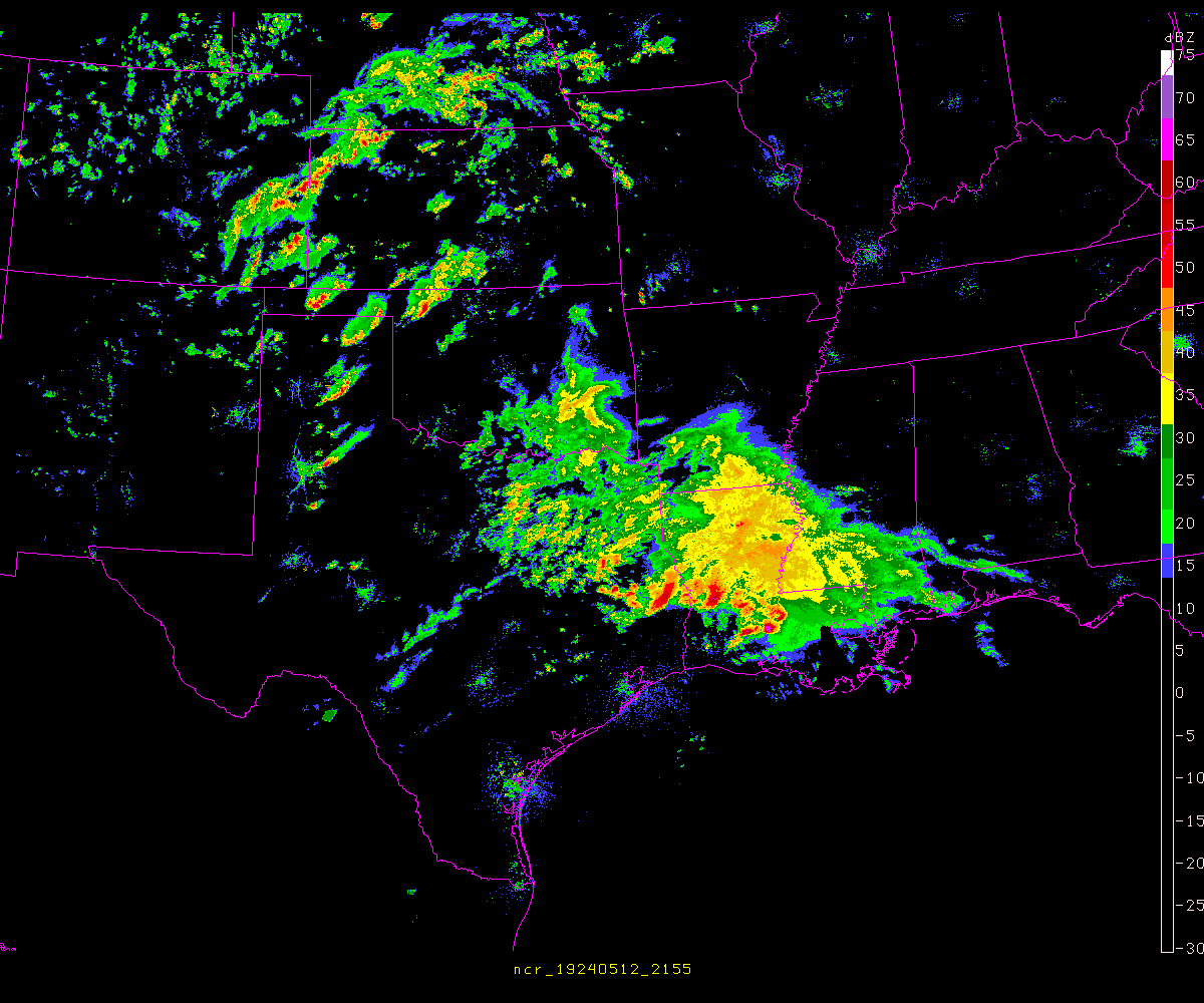
DISCUSSION...THE LATEST IR SATELLITE IMAGERY IS SHOWING NUMEROUS
CLUSTERS OF RAPIDLY COOLING CONVECTIVE TOPS ACROSS THE TX HILL
COUNTRY AND DOWN TOWARD THE RIO GRANDE RIVER AS INCREASINGLY
DIVERGENT FLOW ALOFT AHEAD OF AN UPPER TROUGH INTERACTS WITH A
DEEP POOL OF VERY MOIST AND UNSTABLE AIR.
THE LATEST GOES-SOUNDER LI/S WITH THE AID OF ROBUST DIURNAL
HEATING ARE AS LOW AS -6 TO -8 AND WITH GPS-DERIVED PWATS CLOSE TO
2 INCHES. SBCAPE VALUES ARE NOW RUNNING AS HIGH AS 3000 TO 4000
J/KG...AND ALL OF THIS FAVORABLE THERMODYNAMIC ENERGY IS EXPECTED
TO COUPLE THROUGH THE EVENING WITH AN UPTICK IN DEEP LAYER ASCENT
FOR INCREASINGLY MORE ORGANIZED BANDS OF CONVECTION.
INDIVIDUAL CELL MOTION OVER THE HILL COUNTRY IS GENERALLY TO THE
NORTH...BUT THERE IS EXPECTED TO BE SUFFICIENT CONVECTIVE
ORGANIZATION AND DEVELOPMENT OF A COLD POOL WITH TIME SUCH THAT
CONVECTION WILL ORIENT ITSELF MORE SW/NE WITH THE MEAN FLOW AND
THEN LOCALLY BEGIN GRADUALLY BOWING OFF TO THE EAST AS
ORGANIZATION INCREASES. STRONGER WIND FIELDS ALOFT DOWN TOWARD THE
MIDDLE RIO GRANDE VALLEY ARE ALREADY ALLOWING FOR AN EASTWARD BOW
TO THE CONVECTION HERE.
THE 12Z ARW AND 12Z NMMB ARE BOTH EXPECTED TO BE TOO SLOW WITH THE
EASTWARD CONVECTIVE EVOLUTION DOWN BY THE RIO GRANDE RIVER.
FARTHER NORTH OVER THE HILL COUNTRY AND ESPECIALLY UP INTO
PORTIONS OF NORTH-CENTRAL TX...THE ARW AND NMMB ARE BOTH EXPECTED
TO BE UNDERDONE. THE LATEST RADAR AND SATELLITE TRENDS WOULD FAVOR
A NOTABLY MORE EXPANSIVE AXIS.
THE SET-UP THIS EVENING FAVORS A SW/NE AXIS OF VERY HEAVY AND
POSSIBLY LIFE-THREATENING RAINFALL AMOUNTS GIVEN THE LIKELIHOOD OF
CELL-MERGERS...TRAINING CELLS AND OVERSHOOTING TOPS. ALL
TOGETHER...RAINFALL RATES MAY EXCEED 3 INCHES/HR LOCALLY...AND
THUS VERY IMPRESSIVE STORM TOTAL RAINFALL AMOUNTS WILL BE
POSSIBLE. IN FACT...THE 20Z HRRR SUGGESTS THE POTENTIAL FOR
LOCALLY AS MUCH AS 4 TO 8 INCHES THROUGH MID-EVENING...WITH SOME
OF THE HEAVIEST ACTIVITY FOCUSING JUST NORTH AND WEST OF A LINE
FROM SAN ANTONIO TO AUSTIN TO WACO. WILL CONTINUE TO MONITOR.
ORRISON
ATTN...WFO...CRP...EWX...FWD...SHV...SJT...
May 2015 Record Setting May Rainfall Totals For Region
- srainhoutx
- Site Admin
- Posts: 19685
- Joined: Tue Feb 02, 2010 2:32 pm
- Location: Maggie Valley, NC
- Contact:
You do not have the required permissions to view the files attached to this post.
Carla/Alicia/Jerry(In The Eye)/Michelle/Charley/Ivan/Dennis/Katrina/Rita/Wilma/Humberto/Ike/Harvey
Member: National Weather Association
Facebook.com/Weather Infinity
Twitter @WeatherInfinity
Member: National Weather Association
Facebook.com/Weather Infinity
Twitter @WeatherInfinity
anyone in the know who can help me understand this, please reply
why does the day 1-3 QPF have higher precip totals than the 1-5 right now?
it didn't look like that earlier, but it appears they released a newer day 1-3, it has a lateer time than the 1-5 ?
http://www.wpc.ncep.noaa.gov/qpf/qpf2.shtml
why does the day 1-3 QPF have higher precip totals than the 1-5 right now?
it didn't look like that earlier, but it appears they released a newer day 1-3, it has a lateer time than the 1-5 ?
http://www.wpc.ncep.noaa.gov/qpf/qpf2.shtml
This is definitely one way to fill the central Texas lakes. Just hope everyone stays safe.A large Mesoscale Precipitation Discussion for a lot of folks in Texas has just been issued. 4-8 inches of rainfall possible within the outlined area.
really thankful we've had a beautiful afternoon, it's getting ugly in parts of Texas
http://alerts.weather.gov/cap/tx.php?x=1
http://radar.weather.gov/Conus/southplains.php
wishing all a safe memorial weekend

http://alerts.weather.gov/cap/tx.php?x=1
http://radar.weather.gov/Conus/southplains.php
wishing all a safe memorial weekend
Dear anybody:
Can I look forward to roaring winds (60 MPH) when I wake up at 7AM tomorrow morning? Or just heavy rain. I'm not going anywhere, but anything these storms do outside of heavy rain could cause me some little inconvenience. No drama, just curious.
updated Enhanced Thunderstorm Outlook from SPC, for 04Z-12Z, bringing it closer to Houston area, so don't let your guard down !
also, an updated hazardous weather forecast from HGX http://www.srh.noaa.gov/images/hgx/Briefing.pdf
http://www.spc.noaa.gov/products/exper/enhtstm/

also, an updated hazardous weather forecast from HGX http://www.srh.noaa.gov/images/hgx/Briefing.pdf
http://www.spc.noaa.gov/products/exper/enhtstm/

Voluntary evacuations of 10 subdivisions below Lewis Creek Dam.
See www.mctxoem.org for details and map of affected areas
- Portastorm
- Posts: 800
- Joined: Wed Feb 03, 2010 3:04 pm
- Location: Southwest Austin/Oak Hill, TX
- Contact:
Despite a lot of media hype about tornadic signatures on radar, the line of storms just rolled through most of Austin. We had brief torrential rain, lots of lightning, wind gusts to 50 mph in most places and that was it. I suspect these radar sigs were brief spinups and nothing more as there were zero reports of wall clouds, funnel clouds, or tornadoes on the ground.
If this line keeps together, however, it should be pretty salty by the time it reaches SE Texas.
Portastorm wrote:Despite a lot of media hype about tornadic signatures on radar, the line of storms just rolled through most of Austin. We had brief torrential rain, lots of lightning, wind gusts to 50 mph in most places and that was it. I suspect these radar sigs were brief spinups and nothing more as there were zero reports of wall clouds, funnel clouds, or tornadoes on the ground.
If this line keeps together, however, it should be pretty salty by the time it reaches SE Texas.
You mean--worse than what you've experienced, Portastorm?
- Texaspirate11
- Posts: 1278
- Joined: Tue Dec 31, 2013 12:24 am
- Contact:
Portastorm wrote:Despite a lot of media hype about tornadic signatures on radar, the line of storms just rolled through most of Austin. We had brief torrential rain, lots of lightning, wind gusts to 50 mph in most places and that was it. I suspect these radar sigs were brief spinups and nothing more as there were zero reports of wall clouds, funnel clouds, or tornadoes on the ground.
If this line keeps together, however, it should be pretty salty by the time it reaches SE Texas.
Say it isn't so that its been hyped!
Just because you're disabled, you don't have to be a victim
Be Weather Aware & Prepared!
Barbara Jordan Winner in Media
Disability Integration Consultant
Be Weather Aware & Prepared!
Barbara Jordan Winner in Media
Disability Integration Consultant
- Portastorm
- Posts: 800
- Joined: Wed Feb 03, 2010 3:04 pm
- Location: Southwest Austin/Oak Hill, TX
- Contact:
Unless it weakens or something ... yeah ... the line showed signs of turning into a bow-echo squall line as it passed through our area.Paul Robison wrote:Portastorm wrote:Despite a lot of media hype about tornadic signatures on radar, the line of storms just rolled through most of Austin. We had brief torrential rain, lots of lightning, wind gusts to 50 mph in most places and that was it. I suspect these radar sigs were brief spinups and nothing more as there were zero reports of wall clouds, funnel clouds, or tornadoes on the ground.
If this line keeps together, however, it should be pretty salty by the time it reaches SE Texas.
You mean--worse than what you've experienced, Portastorm?
- Portastorm
- Posts: 800
- Joined: Wed Feb 03, 2010 3:04 pm
- Location: Southwest Austin/Oak Hill, TX
- Contact:
I know, you're shocked aren't you?! LOL.Texaspirate11 wrote:Portastorm wrote:Despite a lot of media hype about tornadic signatures on radar, the line of storms just rolled through most of Austin. We had brief torrential rain, lots of lightning, wind gusts to 50 mph in most places and that was it. I suspect these radar sigs were brief spinups and nothing more as there were zero reports of wall clouds, funnel clouds, or tornadoes on the ground.
If this line keeps together, however, it should be pretty salty by the time it reaches SE Texas.
Say it isn't so that its been hyped!
- srainhoutx
- Site Admin
- Posts: 19685
- Joined: Tue Feb 02, 2010 2:32 pm
- Location: Maggie Valley, NC
- Contact:
24 hour rainfall totals for the NWS Austin/San Antonio area.
You do not have the required permissions to view the files attached to this post.
Carla/Alicia/Jerry(In The Eye)/Michelle/Charley/Ivan/Dennis/Katrina/Rita/Wilma/Humberto/Ike/Harvey
Member: National Weather Association
Facebook.com/Weather Infinity
Twitter @WeatherInfinity
Member: National Weather Association
Facebook.com/Weather Infinity
Twitter @WeatherInfinity
- Texaspirate11
- Posts: 1278
- Joined: Tue Dec 31, 2013 12:24 am
- Contact:
Here is a picture from BOERNE, TEXAS from the Leon Springs FD
Looks pretty bad...
Looks pretty bad...
You do not have the required permissions to view the files attached to this post.
Just because you're disabled, you don't have to be a victim
Be Weather Aware & Prepared!
Barbara Jordan Winner in Media
Disability Integration Consultant
Be Weather Aware & Prepared!
Barbara Jordan Winner in Media
Disability Integration Consultant
- Texaspirate11
- Posts: 1278
- Joined: Tue Dec 31, 2013 12:24 am
- Contact:
Here is a picture of the Riverwalk in San Antonio....
You do not have the required permissions to view the files attached to this post.
Just because you're disabled, you don't have to be a victim
Be Weather Aware & Prepared!
Barbara Jordan Winner in Media
Disability Integration Consultant
Be Weather Aware & Prepared!
Barbara Jordan Winner in Media
Disability Integration Consultant
- srainhoutx
- Site Admin
- Posts: 19685
- Joined: Tue Feb 02, 2010 2:32 pm
- Location: Maggie Valley, NC
- Contact:
Flooding issues a growing concern across portions of the Hill Country and SE Texas as we begin Sunday. A rather potent upper air disturbance (shortwave) is diving S across California and will likely impact our Monday weather.


Carla/Alicia/Jerry(In The Eye)/Michelle/Charley/Ivan/Dennis/Katrina/Rita/Wilma/Humberto/Ike/Harvey
Member: National Weather Association
Facebook.com/Weather Infinity
Twitter @WeatherInfinity
Member: National Weather Association
Facebook.com/Weather Infinity
Twitter @WeatherInfinity
From the City of San Marcos, TX - City Hall Facebook Page:
Please stay safe everyone in the dangerous, life threatening situation. Houston and SE TX I think will have some dangerous Flash Flooding on Sunday, Sunday night into Monday. Make smart choices!EVACUATIONS for some parts of the City - Emergency officials in San Marcos have elected to evacuate certain areas of the city near the Blanco river based upon previous flood data and the anticipated water level within the next two to four hours. Based upon water levels seen in Wimberley and further west, officials feel strongly that areas of the city near the Blanco river will flood to a degree necessitating this evacuation.
Residents along the Blanco including those in the Blanco Gardens area, Crepe Myrtle/Pecan/Hackberry Street area, and the portions of Blanco Vista nearest to the river must evacuate. Police officers and firefighters will begin making door to door notifications immediately. If you are in doubt and are near the river, please move to higher ground immediately. Residents should first attempt to seek shelter with friends or family before going to any emergency shelter if possible.
A temporary shelter is available at the San Marcos Activity Center for those who cannot go to another location.
Blake
Boomer Sooner
Boomer Sooner
https://twitter.com/NWSSanAntonio
"Flood wave along the Blanco River is moving into San Marcos. River has gone up 6.5 feet in 10 minutes. "
"It appears that we have lost the Blanco River @ Wimberley, which has not reported since about 1am. At that time, the gauge was at 40.21 ft."
"Flood wave along the Blanco River is moving into San Marcos. River has gone up 6.5 feet in 10 minutes. "
"It appears that we have lost the Blanco River @ Wimberley, which has not reported since about 1am. At that time, the gauge was at 40.21 ft."
insane-looking on radar

WDSS-II on Google Map: http://wdssii.nssl.noaa.gov/maps/ (can add warnings, meso discussions, etc...)
loop: http://wdssii.nssl.noaa.gov/web/wdss2/p ... loop.shtml

precip options: http://wdssii.nssl.noaa.gov/web/wdss2/p ... ecip.shtml
WDSS-II on Google Map: http://wdssii.nssl.noaa.gov/maps/ (can add warnings, meso discussions, etc...)
loop: http://wdssii.nssl.noaa.gov/web/wdss2/p ... loop.shtml

precip options: http://wdssii.nssl.noaa.gov/web/wdss2/p ... ecip.shtml
-
- Information
-
Who is online
Users browsing this forum: Ahrefs [Bot], Bing [Bot], TexasBreeze and 5 guests