INVEST 90L. Off The SE US Coast. Code Yellow.

Tropical Weather Discussions and Analysis
User avatar
srainhoutx
Site Admin
Site Admin
Posts: 19685
Joined: Tue Feb 02, 2010 2:32 pm
Location: Maggie Valley, NC
Contact:

And so the Season begins...

BEGIN
NHC_ATCF
invest_al902010.invest
FSTDA
R
U
040
010
0000
201005211219
NONE
NOTIFY=ATRP
END
INVEST, AL, L, , , , , 90, 2010, DB, O, 2010052112, 9999999999, , , , , , METWATCH, , AL902010
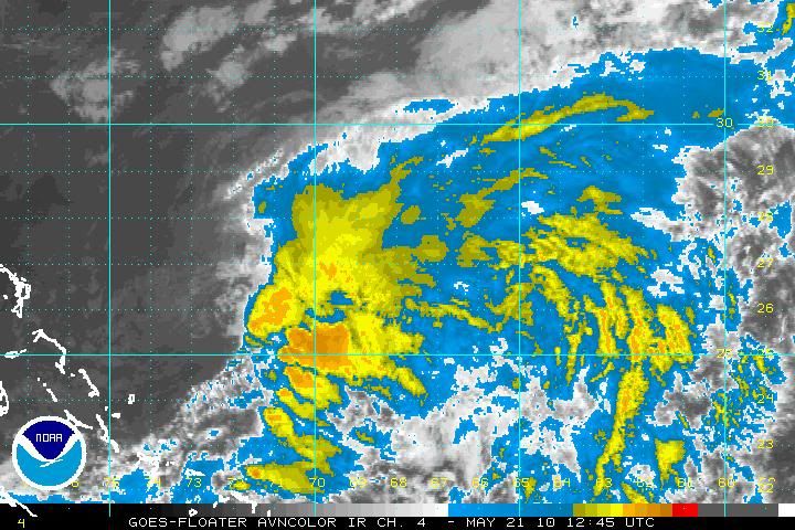
AL, 90, 2010052012, , BEST, 0, 270N, 718W, 15, 1015, DB, 0, , 0, 0, 0, 0,
AL, 90, 2010052018, , BEST, 0, 272N, 717W, 15, 1015, DB, 0, , 0, 0, 0, 0,
AL, 90, 2010052100, , BEST, 0, 274N, 717W, 15, 1015, DB, 0, , 0, 0, 0, 0,
AL, 90, 2010052106, , BEST, 0, 276N, 720W, 20, 1014, DB, 0, , 0, 0, 0, 0,
AL, 90, 2010052112, , BEST, 0, 275N, 723W, 25, 1013, DB, 34, NEQ, 0, 0, 0, 0, 1015, 80, 40, 0, 0, L, 0, , 0, 0, INVEST, S,

TROPICAL CYCLONE GUIDANCE MESSAGE
NWS TPC/NATIONAL HURRICANE CENTER MIAMI FL
1221 UTC FRI MAY 21 2010

DISCLAIMER...NUMERICAL MODELS ARE SUBJECT TO LARGE ERRORS.
PLEASE REFER TO NHC OFFICIAL FORECASTS FOR TROPICAL CYCLONE
AND SUBTROPICAL CYCLONE INFORMATION.

ATLANTIC OBJECTIVE AIDS FOR

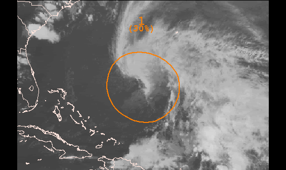
DISTURBANCE INVEST (AL902010) 20100521 1200 UTC

...00 HRS... ...12 HRS... ...24 HRS. .. ...36 HRS...
100521 1200 100522 0000 100522 1200 100523 0000

LAT LON LAT LON LAT LON LAT LON
BAMS 27.5N 72.3W 27.5N 73.1W 27.4N 74.4W 27.1N 75.7W
BAMD 27.5N 72.3W 27.4N 69.8W 28.0N 68.7W 29.3N 68.7W
BAMM 27.5N 72.3W 27.3N 72.4W 27.2N 73.0W 27.2N 73.6W
LBAR 27.5N 72.3W 27.9N 71.3W 28.2N 70.7W 28.7N 70.1W
SHIP 25KTS 26KTS 26KTS 24KTS
DSHP 25KTS 26KTS 26KTS 24KTS

...48 HRS... ...72 HRS... ...96 HRS. .. ..120 HRS...
100523 1200 100524 1200 100525 1200 100526 1200

LAT LON LAT LON LAT LON LAT LON
BAMS 26.6N 77.3W 25.4N 80.6W 24.6N 83.6W 24.5N 85.7W
BAMD 30.9N 69.1W 34.6N 70.0W 36.6N 74.4W 36.3N 79.7W
BAMM 26.8N 74.3W 25.4N 75.4W 25.5N 71.4W 31.0N 66.6W
LBAR 29.2N 69.7W 30.9N 68.7W 35.2N 66.9W 38.7N 65.6W
SHIP 19KTS 0KTS 0KTS 0KTS
DSHP 19KTS 0KTS 0KTS 0KTS

...INITIAL CONDITIONS...
LATCUR = 27.5N LONCUR = 72.3W DIRCUR = 300DEG SPDCUR = 2KT
LATM12 = 27.4N LONM12 = 71.7W DIRM12 = 326DEG SPDM12 = 2KT
LATM24 = 27.0N LONM24 = 71.8W
WNDCUR = 25KT RMAXWD = 40NM WNDM12 = 15KT
CENPRS = 1013MB OUTPRS = 1015MB OUTRAD = 80NM SDEPTH = S
RD34NE = 0NM RD34SE = 0NM RD34SW = 0NM RD34NW = 0NM

$$
NNNN

Image

Image
Carla/Alicia/Jerry(In The Eye)/Michelle/Charley/Ivan/Dennis/Katrina/Rita/Wilma/Humberto/Ike/Harvey

Member: National Weather Association
Facebook.com/Weather Infinity
Twitter @WeatherInfinity
User avatar
srainhoutx
Site Admin
Site Admin
Posts: 19685
Joined: Tue Feb 02, 2010 2:32 pm
Location: Maggie Valley, NC
Contact:

We can probably discount the track models (early on) in favor of the Globals with this type of Hybrid system.
Carla/Alicia/Jerry(In The Eye)/Michelle/Charley/Ivan/Dennis/Katrina/Rita/Wilma/Humberto/Ike/Harvey

Member: National Weather Association
Facebook.com/Weather Infinity
Twitter @WeatherInfinity
User avatar
srainhoutx
Site Admin
Site Admin
Posts: 19685
Joined: Tue Feb 02, 2010 2:32 pm
Location: Maggie Valley, NC
Contact:

Certainly not going anywhere fast. Best chance of some development would likely be over the next 2 to 3 days.

Image
Carla/Alicia/Jerry(In The Eye)/Michelle/Charley/Ivan/Dennis/Katrina/Rita/Wilma/Humberto/Ike/Harvey

Member: National Weather Association
Facebook.com/Weather Infinity
Twitter @WeatherInfinity
User avatar
Paul
Posts: 535
Joined: Wed Feb 03, 2010 11:46 pm
Location: Pearland
Contact:

finally!!, latest vis loop looks like a low level eddie spun off and died to the west. Shear though is all around this thing. Aint going to make it very far but hey its fun to see something this soon in May.....

http://cimss.ssec.wisc.edu/tropic/real- ... g8sht.html
User avatar
srainhoutx
Site Admin
Site Admin
Posts: 19685
Joined: Tue Feb 02, 2010 2:32 pm
Location: Maggie Valley, NC
Contact:

12Z ECMWF suggests that a Low Pressure circulation will approach the Outer Banks of NC and then drop SW by next Saturday.

Image

Image
Carla/Alicia/Jerry(In The Eye)/Michelle/Charley/Ivan/Dennis/Katrina/Rita/Wilma/Humberto/Ike/Harvey

Member: National Weather Association
Facebook.com/Weather Infinity
Twitter @WeatherInfinity
User avatar
Paul
Posts: 535
Joined: Wed Feb 03, 2010 11:46 pm
Location: Pearland
Contact:

CMC, NOGAPS, GDFL all agree on an hybrid system but I just dont see anything stacking with all the shear around it. I see two LLCs spin off and die now to the west with another looking MLC closer to the main blob. Hard to tell if another LLC is trying to form under it. Its fighting some killer shear right now.

http://www.ghcc.msfc.nasa.gov/GOES/goeseastconus.html
User avatar
Paul
Posts: 535
Joined: Wed Feb 03, 2010 11:46 pm
Location: Pearland
Contact:

if the EURO is biting on developement then there must be something I am not seeing. 60knots of shear over head will not let anything stack in the short term.
User avatar
Paul
Posts: 535
Joined: Wed Feb 03, 2010 11:46 pm
Location: Pearland
Contact:

you can see what looks to be a LLC displaced to the west of the main blob...its moving west with the low level flow while mid-level shear is moving the storms off to the east. 40knots of shear over it now....unless something odd happens this LLC will shear out and die also. I am surprised that models are still showing developement.


http://cimss.ssec.wisc.edu/tropic/real- ... g8sht.html
User avatar
srainhoutx
Site Admin
Site Admin
Posts: 19685
Joined: Tue Feb 02, 2010 2:32 pm
Location: Maggie Valley, NC
Contact:

Look for a second more dominate low to become established in the next 24 hours or so. We may yet see a named storm from this disturbance.
Carla/Alicia/Jerry(In The Eye)/Michelle/Charley/Ivan/Dennis/Katrina/Rita/Wilma/Humberto/Ike/Harvey

Member: National Weather Association
Facebook.com/Weather Infinity
Twitter @WeatherInfinity
User avatar
Paul
Posts: 535
Joined: Wed Feb 03, 2010 11:46 pm
Location: Pearland
Contact:

srainhoutx wrote:Look for a second more dominate low to become established in the next 24 hours or so. We may yet see a named storm from this disturbance.
I agree with all the model support but just by vis its look very disorganized. Shear tendency is only going up.

http://www.ghcc.msfc.nasa.gov/GOES/goeseastconus.html

http://cimss.ssec.wisc.edu/tropic/real- ... g8sht.html

also the last 0z EURO backs off somewhat on intensity from last run. Have to see if its a trend.
User avatar
Paul
Posts: 535
Joined: Wed Feb 03, 2010 11:46 pm
Location: Pearland
Contact:

looks better than yesterday...another LLC spinning off to the SW and dying but looking for another one under that semi- deep convection....still have model agreement.....shear decreasing...got some dry air around it...

http://www.ssd.noaa.gov/goes/flt/t1/flash-wv.html

http://cimss.ssec.wisc.edu/tropic/real- ... g8sht.html
User avatar
srainhoutx
Site Admin
Site Admin
Posts: 19685
Joined: Tue Feb 02, 2010 2:32 pm
Location: Maggie Valley, NC
Contact:

A lot of dry continental air influencing 90L. It does look a bit better at this time...

Image
Carla/Alicia/Jerry(In The Eye)/Michelle/Charley/Ivan/Dennis/Katrina/Rita/Wilma/Humberto/Ike/Harvey

Member: National Weather Association
Facebook.com/Weather Infinity
Twitter @WeatherInfinity
User avatar
srainhoutx
Site Admin
Site Admin
Posts: 19685
Joined: Tue Feb 02, 2010 2:32 pm
Location: Maggie Valley, NC
Contact:

TROPICAL WEATHER DISCUSSION
NWS TPC/NATIONAL HURRICANE CENTER MIAMI FL
205 PM EDT SUN MAY 23 2010

TROPICAL WEATHER DISCUSSION FOR NORTH AMERICA...CENTRAL
AMERICA...GULF OF MEXICO...CARIBBEAN SEA...NORTHERN SECTIONS OF
SOUTH AMERICA...AND ATLANTIC OCEAN TO THE AFRICAN COAST FROM THE
EQUATOR TO 32N. THE FOLLOWING INFORMATION IS BASED ON SATELLITE
IMAGERY...METEOROLOGICAL ANALYSIS...WEATHER OBSERVATIONS...AND
RADAR.

BASED ON 1200 UTC SURFACE ANALYSIS AND SATELLITE IMAGERY THROUGH
1715 UTC...

...SPECIAL FEATURES...

A SURFACE TROUGH EXTENDS FROM 27N69W THROUGH A WEAKENING 1008 MB
LOW NEAR 25N70W TO THE TURKS AND CAICOS NEAR 22N72W. SATELLITE
SUGGESTS THAT A SECOND LOW IS DEVELOPING TO THE NORTH OF THE
CURRENT LOW AND WILL BE ADDED AT 23/1800 UTC.
SCATTERED SHOWERS/
ISOLATED THUNDERSTORMS ARE N AND E OF THE LOW WITHIN 120/150 NM
OF LINE FROM 22N58W TO 29N69W AND ISOLATED/SCATTERED SHOWERS
WITH ISOLATED THUNDERSTORMS WITHIN 60/75 NM OF LINE FROM 21N67W
TO 23N65W. GALE FORCE WINDS ARE FOUND FROM 27N-29N BETWEEN
64W-70W. THIS SYSTEM IS EXPECTED TO MOVE N AND BE N OF THE
REGION BY LATE TUE NIGHT THEN WILL DRIFT E THROUGH THU.
Carla/Alicia/Jerry(In The Eye)/Michelle/Charley/Ivan/Dennis/Katrina/Rita/Wilma/Humberto/Ike/Harvey

Member: National Weather Association
Facebook.com/Weather Infinity
Twitter @WeatherInfinity
User avatar
Paul
Posts: 535
Joined: Wed Feb 03, 2010 11:46 pm
Location: Pearland
Contact:

this has been spitting out its LLC for the last 2 days....I see another one to the NE as ED alluded too. WV image shows the dry air. One of those wait and see really...


BTW- NOAA has a floater on the oil spill? I tried every sat view and cant see any difference...
User avatar
wxdata
Site Admin
Site Admin
Posts: 1059
Joined: Wed Feb 03, 2010 3:04 pm
Location: Houston, TX
Contact:

Bastardi's thoughts on 90L and additional thoughts on the upcoming hurricane season..

http://www.accuweather.com/video/245282 ... idweek.asp
User avatar
Paul
Posts: 535
Joined: Wed Feb 03, 2010 11:46 pm
Location: Pearland
Contact:

Ed Mahmoud wrote:
Paul wrote:this has been spitting out its LLC for the last 2 days....I see another one to the NE as ED alluded too. WV image shows the dry air. One of those wait and see really...


BTW- NOAA has a floater on the oil spill? I tried every sat view and cant see any difference...
I've seen satellite imagery that showed the spill. But that appeared an actual color photograph, not a black and white visible image. I'm sure none of the various IR channels would pick that up very well.


More of a "is it raining where they're skimming oil" kind of thing. Out of season, one group of URLS devoted to a close-up of the spill area doesn't hurt anything, I'd guess.

ATS has some great pics of the spill from a passenger flying over in a commercial jet. Nasty spill. Even nastier if we get a Hurricane in the GOM....Which we will BTW...


JB at it again. I love the way he circles basically the entire Gulf coast and EC for landfalls. He is dead on with the lower pressures forecasted as he has been all year though.

It is fixing to be show time in the Tropics.... :shock: still got to change my oil in my generator.
User avatar
srainhoutx
Site Admin
Site Admin
Posts: 19685
Joined: Tue Feb 02, 2010 2:32 pm
Location: Maggie Valley, NC
Contact:

Image

ZCZC MIATWOAT ALL
TTAA00 KNHC DDHHMM
SPECIAL TROPICAL WEATHER OUTLOOK
NWS TPC/NATIONAL HURRICANE CENTER MIAMI FL
825 PM EDT SUN MAY 23 2010

FOR THE NORTH ATLANTIC...CARIBBEAN SEA AND THE GULF OF MEXICO...

1. A NON-TROPICAL LOW PRESSURE SYSTEM CENTERED ABOUT 500 MILES
SOUTH-SOUTHWEST OF BERMUDA IS PRODUCING A LARGE AREA OF
DISORGANIZED SHOWERS AND THUNDERSTORMS OVER THE SOUTHWESTERN
ATLANTIC OCEAN ALONG WITH GALE-FORCE WINDS. THIS LOW IS EXPECTED
TO MOVE SLOWLY TOWARD THE NORTH-NORTHWEST AND HAS SOME POTENTIAL
TO GRADUALLY ACQUIRE SUBTROPICAL OR TROPICAL CHARACTERISTICS DURING
THE NEXT COUPLE OF DAYS. THERE IS A MEDIUM CHANCE...30
PERCENT...OF THIS SYSTEM BECOMING A SUBTROPICAL OR TROPICAL CYCLONE
DURING THE NEXT 48 HOURS.
FOR ADDITIONAL INFORMATION...PLEASE SEE
HIGH SEAS FORECASTS ISSUED BY THE NATIONAL WEATHER SERVICE...UNDER
AWIPS HEADER NFDHSFAT1 AND WMO HEADER FZNT01 KWBC. THE NEXT
STATEMENT ON THIS SYSTEM WILL BE ISSUED BY MIDDAY MONDAY.

$$
FORECASTER BLAKE
Carla/Alicia/Jerry(In The Eye)/Michelle/Charley/Ivan/Dennis/Katrina/Rita/Wilma/Humberto/Ike/Harvey

Member: National Weather Association
Facebook.com/Weather Infinity
Twitter @WeatherInfinity
Hardcoreweather

Code Orange

Atlantic Graphical Tropical Weather Outlook

This product is updated at approximately 2 AM, 8 AM, 2 PM, and 8 PM EDT from June 1 to November 30. Special outlooks may be issued as conditions warrant.
Place your mouse cursor over areas of interest for more information Archived Outlooks [LEFT] Image
[/LEFT]
ZCZC MIATWOAT ALL
TTAA00 KNHC DDHHMM
SPECIAL TROPICAL WEATHER OUTLOOK
NWS TPC/NATIONAL HURRICANE CENTER MIAMI FL
825 PM EDT SUN MAY 23 2010

FOR THE NORTH ATLANTIC...CARIBBEAN SEA AND THE GULF OF MEXICO...

1. A NON-TROPICAL LOW PRESSURE SYSTEM CENTERED ABOUT 500 MILES
SOUTH-SOUTHWEST OF BERMUDA IS PRODUCING A LARGE AREA OF
DISORGANIZED SHOWERS AND THUNDERSTORMS OVER THE SOUTHWESTERN
ATLANTIC OCEAN ALONG WITH GALE-FORCE WINDS. THIS LOW IS EXPECTED
TO MOVE SLOWLY TOWARD THE NORTH-NORTHWEST AND HAS SOME POTENTIAL
TO GRADUALLY ACQUIRE SUBTROPICAL OR TROPICAL CHARACTERISTICS DURING
THE NEXT COUPLE OF DAYS. THERE IS A MEDIUM CHANCE...30
PERCENT...OF THIS SYSTEM BECOMING A SUBTROPICAL OR TROPICAL CYCLONE
DURING THE NEXT 48 HOURS. FOR ADDITIONAL INFORMATION...PLEASE SEE
HIGH SEAS FORECASTS ISSUED BY THE NATIONAL WEATHER SERVICE...UNDER
AWIPS HEADER NFDHSFAT1 AND WMO HEADER FZNT01 KWBC. THE NEXT
STATEMENT ON THIS SYSTEM WILL BE ISSUED BY MIDDAY MONDAY.

$$
FORECASTER BLAKE
NNNN
Post Reply
  • Information
  • Who is online

    Users browsing this forum: No registered users and 4 guests