
December 2014: New Year's Eve Wintry Mix Possible
-
srainhoutx

- Site Admin

- Posts: 19700
- Joined: Tue Feb 02, 2010 2:32 pm
- Location: Maggie Valley, NC
- Contact:
The 12Z Euro suggests that this much talked about cold and stormy pattern near New Years Eve may well be valid. The Euro drops a big trough into the Great Basin and begins to move E toward the Plains as a Winter storm develops over New Mexico and NW Texas as a Coastal low/wave begins to organize along the Lower Texas Coast. Also note the activity NE of Hawaii. That is the sub tropical jet becoming very active and should provide additional moisture after the cold air becomes entrenched across the Region. It appears another disturbance is dropping S from Western Canada that should arrive a day or two beyond New Years Day.
Carla/Alicia/Jerry(In The Eye)/Michelle/Charley/Ivan/Dennis/Katrina/Rita/Wilma/Humberto/Ike/Harvey
Member: National Weather Association
Facebook.com/Weather Infinity
Twitter @WeatherInfinity
Member: National Weather Association
Facebook.com/Weather Infinity
Twitter @WeatherInfinity
-
ronyan
- Posts: 214
- Joined: Tue Jun 29, 2010 7:23 pm
- Location: Clute, TX
- Contact:
12z GFS shows a 1061mb high entering Montana @ 240 hrs. If that happens it will send a strong arctic front likely blasting straight down the Rockies and into TX.
The signs of a pattern change are evident at the 500mb level, 570+ dam heights just South of Alaska in 8 days.
The signs of a pattern change are evident at the 500mb level, 570+ dam heights just South of Alaska in 8 days.
-
Paul Robison
What are the prospects for severe thunderstorms on Tuesday of this coming Christmas week?
-
brooksgarner

- Global Moderator

- Posts: 226
- Joined: Tue Jun 04, 2013 3:06 pm
- Location: Houston, TX
- Contact:
Of interest... a professional, non-TV storm chaser SUV vehicle from the plains (complete with antennas, anemometer, marked with graphics) -- was spotted driving down Pinellas Blvd near St. Pete, FL at 3:30am this morning -- and the person that spotted him didn't think he was there to visit grandma for the holidays! Computer models are showing that front pushing into the Gulf coast of FL on the morning of Christmas Eve (Wednesday), with diffulent jet from coastal Mississippi to roughly Cedar Key, but so far seem to be advertizing the heaviest stuff offshore (GFS/EURO/CMC), due to the squall line essentially outrunning the best jet dynamics and PVA... So, much appears to weaken before pushing inland. For us in Houston, this will only enhance the cooler weather preceding Christmas -- maybe some frost Christmas morning... So, maybe he's headed to to coast to charter a boat?? haha ..... Or, maybe the storm chaser was looking for an excuse to hit the white sands of Siesta Key Beach, under the guise to his family that he's "out working"? Who would think showing up in a certain type of vehicle would cause so much concern... It's like Jim Cantore setting up for a live shot in your neighborhood. (If that ever happens, run.)
Broadcast Met
http://BrooksGarner.com
http://twitter.com/BrooksWeather
http://BrooksGarner.com
http://twitter.com/BrooksWeather
- '17 Harvey
- '12 Sandy (P3 Orion)
- '91 Bob
- '85 Gloria
-
ronyan
- Posts: 214
- Joined: Tue Jun 29, 2010 7:23 pm
- Location: Clute, TX
- Contact:
Ineresting, would be great to see 30s Christmas morning.brooksgarner wrote:Of interest... a professional, non-TV storm chaser SUV vehicle from the plains (complete with antennas, anemometer, marked with graphics) -- was spotted driving down Pinellas Blvd near St. Pete, FL at 3:30am this morning -- and the person that spotted him didn't think he was there to visit grandma for the holidays! Computer models are showing that front pushing into the Gulf coast of FL on the morning of Christmas Eve (Wednesday), with good jet dynamics from the Panhandle (of FL) to Cedar Key, but so far seem to be advertizing the heaviest stuff offshore (GFS/EURO/CMC) -- weakening as it pushes inland. For us in Houston, it'll only enhance the cooler weather preceding Christmas: maybe some frost Christmas morning... So, maybe he's headed to to coast to charter a boat?? haha
-
Portastorm

- Posts: 800
- Joined: Wed Feb 03, 2010 3:04 pm
- Location: Southwest Austin/Oak Hill, TX
- Contact:
While the 0z GFS backed off some on the magnitude of cold for South and Southeast Texas after Christmas, the 12z GFS looks like it's back on the "Arctic Express" theme. Progged high temps on New Year's Day don't get above freezing for the northern half of the state with highs in the mid 30s for the Houston area. I suspect we will continue to see computer model volatility until they get a better handle on the pattern change ahead.
-
srainhoutx
- Site Admin
- Posts: 19700
- Joined: Tue Feb 02, 2010 2:32 pm
- Location: Maggie Valley, NC
- Contact:
The 12Z ECMWF is also advertising some chilly temperatures across our Region in the wake of the Christmas Eve storm that may create some travel troubles across the Great Lakes, Ohio and Tennessee River Valleys and from Florida all the way up to New England.
The longer range Euro is also onboard with a significant Arctic airmass plunging S across the Inter Mountain West and the Plains to the NW Gulf Coast on New Years Eve. The Arctic from looks to be nearing SE Louisiana by New Years Eve evening festivities.
The longer range Euro is also onboard with a significant Arctic airmass plunging S across the Inter Mountain West and the Plains to the NW Gulf Coast on New Years Eve. The Arctic from looks to be nearing SE Louisiana by New Years Eve evening festivities.
Carla/Alicia/Jerry(In The Eye)/Michelle/Charley/Ivan/Dennis/Katrina/Rita/Wilma/Humberto/Ike/Harvey
Member: National Weather Association
Facebook.com/Weather Infinity
Twitter @WeatherInfinity
Member: National Weather Association
Facebook.com/Weather Infinity
Twitter @WeatherInfinity
-
harpman
- Posts: 212
- Joined: Thu Feb 04, 2010 10:36 am
- Location: New Orleans, La.
- Contact:
Any moisture with the New year's eve air mass?
-
srainhoutx
- Site Admin
- Posts: 19700
- Joined: Tue Feb 02, 2010 2:32 pm
- Location: Maggie Valley, NC
- Contact:
I am more concerned for you folks in SE Louisiana with the December 23rd storm system and a severe weather event associated with that very deep trough. The SPC already has a Slight Risk for severe storms across portions of Central/SE Louisiana and Mississippi.harpman wrote:Any moisture with the New year's eve air mass?
Carla/Alicia/Jerry(In The Eye)/Michelle/Charley/Ivan/Dennis/Katrina/Rita/Wilma/Humberto/Ike/Harvey
Member: National Weather Association
Facebook.com/Weather Infinity
Twitter @WeatherInfinity
Member: National Weather Association
Facebook.com/Weather Infinity
Twitter @WeatherInfinity
-
Ptarmigan

- Statistical Specialist

- Posts: 4521
- Joined: Wed Feb 03, 2010 7:20 pm
- Contact:
If that forecast materializes that high would be on par with 1895, 1899, 1951, 1962, 1983, and 1989.ronyan wrote:12z GFS shows a 1061mb high entering Montana @ 240 hrs. If that happens it will send a strong arctic front likely blasting straight down the Rockies and into TX.
The signs of a pattern change are evident at the 500mb level, 570+ dam heights just South of Alaska in 8 days.
-
ronyan
- Posts: 214
- Joined: Tue Jun 29, 2010 7:23 pm
- Location: Clute, TX
- Contact:
The 12z GFS today shows a 1056mb entering the US, slightly weaker than before...but still a very powerful HP.Ptarmigan wrote:If that forecast materializes that high would be on par with 1895, 1899, 1951, 1962, 1983, and 1989.ronyan wrote:12z GFS shows a 1061mb high entering Montana @ 240 hrs. If that happens it will send a strong arctic front likely blasting straight down the Rockies and into TX.
The signs of a pattern change are evident at the 500mb level, 570+ dam heights just South of Alaska in 8 days.
-
ronyan
- Posts: 214
- Joined: Tue Jun 29, 2010 7:23 pm
- Location: Clute, TX
- Contact:
For comparison, here's what the high looked like over the Northern plains during the 1989 outbreak:
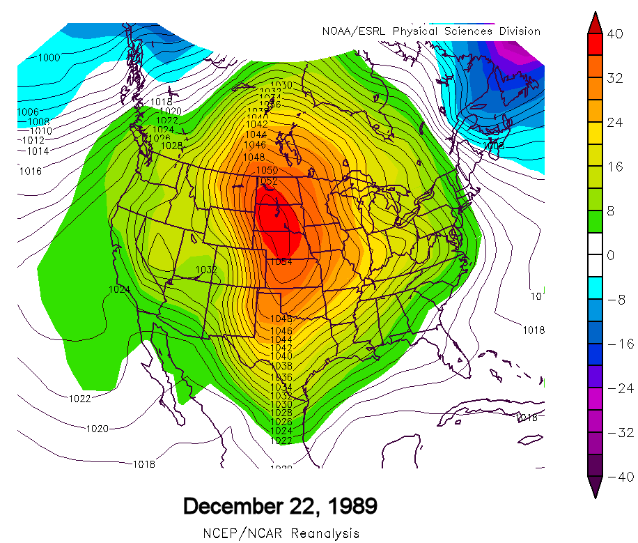
~1055 mb high centered over South Dakota. Pressures eventually climbed to 1046mb in Houston, 30.89 in.
~1055 mb high centered over South Dakota. Pressures eventually climbed to 1046mb in Houston, 30.89 in.
-
Paul Robison
Does this record cold the models are showing mean the first rolling outages across Houston since 2011? Is this another 1989/2011 type severe event. Sorry for any trolling, but I just spent two hours in the dark this morning due to a blown fuse. Would like to hear anyone's thoughts on this.
-
Portastorm
- Posts: 800
- Joined: Wed Feb 03, 2010 3:04 pm
- Location: Southwest Austin/Oak Hill, TX
- Contact:
I don't think the models are showing record cold at this point. Some of the longer range analyses suggest the pattern could end resembling 1983 or 1989 and other times of very cold air ... but even the predicted pattern via the models at this moment doesn't match 1989 as depicted above. It's just something to keep an eye on at this point. Those events in 1983 and 89 were once in a lifetime events that oddly enough occurred in the same decade. Very, very rare.
-
ronyan
- Posts: 214
- Joined: Tue Jun 29, 2010 7:23 pm
- Location: Clute, TX
- Contact:
I'm not sure we actually know how rare those events are, records only go back so far and there were very extreme events in the 1890s.
But yeah, record cold is not shown on the models. I was posting that due to some of the pattern analogs from the CPC the last couple days.
But yeah, record cold is not shown on the models. I was posting that due to some of the pattern analogs from the CPC the last couple days.
-
harpman
- Posts: 212
- Joined: Thu Feb 04, 2010 10:36 am
- Location: New Orleans, La.
- Contact:
-
srainhoutx
- Site Admin
- Posts: 19700
- Joined: Tue Feb 02, 2010 2:32 pm
- Location: Maggie Valley, NC
- Contact:
It looks like Christmas will be comfortably chilly after the models were 'predicting' some 70's for highs. Christmas morning may see some mid to upper 30's with afternoon highs in the mid to upper 50's.
Carla/Alicia/Jerry(In The Eye)/Michelle/Charley/Ivan/Dennis/Katrina/Rita/Wilma/Humberto/Ike/Harvey
Member: National Weather Association
Facebook.com/Weather Infinity
Twitter @WeatherInfinity
Member: National Weather Association
Facebook.com/Weather Infinity
Twitter @WeatherInfinity
-
BlueJay
- Posts: 938
- Joined: Tue Mar 04, 2014 10:47 am
- Location: Alden Bridge-The Woodlands, Texas
- Contact:
So happy that this forum is back up!
It would be lovely to have a "comfortably chilly" Christmas day. I hope that the sky is blue and the sun is shining. (A Thanksgiving day repeat - Chamber of Commerce type of weather!)
It would be lovely to have a "comfortably chilly" Christmas day. I hope that the sky is blue and the sun is shining. (A Thanksgiving day repeat - Chamber of Commerce type of weather!)
-
snowman65

- Posts: 1415
- Joined: Thu Feb 04, 2010 6:39 am
- Location: Orange, Tx
- Contact:
Is Dec 31-Jan 3 just looking cold and wet with no "fun" for Austin area?
-
srainhoutx
- Site Admin
- Posts: 19700
- Joined: Tue Feb 02, 2010 2:32 pm
- Location: Maggie Valley, NC
- Contact:
snowman65 wrote:Is Dec 31-Jan 3 just looking cold and wet with no "fun" for Austin area?
The computer guidance is struggling even 24 hours out with the current storm. For instance yesterday afternoon NWS Albuquerque had a Winter Weather Advisory for the Northern Mountains of New Mexico and this morning they had to upgrade to Winter Storm Warnings and issue them further S into the Central Mountains. NWS AMA and LUB as well as MAF issued a Special Weather Statement regarding some light snow potential across W and NW Texas. It's very typical for the computer models to under estimate storms and the depth of the cold air.
Carla/Alicia/Jerry(In The Eye)/Michelle/Charley/Ivan/Dennis/Katrina/Rita/Wilma/Humberto/Ike/Harvey
Member: National Weather Association
Facebook.com/Weather Infinity
Twitter @WeatherInfinity
Member: National Weather Association
Facebook.com/Weather Infinity
Twitter @WeatherInfinity