September 2014: Seasonably Warm & Dry To End The Month

General Weather Discussions and Analysis
Post Reply
User avatar
srainhoutx
Site Admin
Site Admin
Posts: 19685
Joined: Tue Feb 02, 2010 2:32 pm
Location: Maggie Valley, NC
Contact:

The cool front has arrived! College Station has dropped to a chilly 65F at this time with breezy N winds gusting to 23 MPH. Dry air is filtering in but expect clouds and light showers and some storms mainly near Matagorda Bay to continue this morning.

Our Bay of Campeche disturbance yesterday morning has moved WNW and 94L was designated last night from what we could clearly see that a surface low had developed. The low is moving inland near Tampico andheavy storms are firing N of the low near Brownsville where up to 5 inches of rain may fall today.

92L continues to move W across the Eastern Gulf and the 06Z track guidance brings this disturbance into the Middle/Lower Texas Coast mid week. No real development is expected as wind shear and a weak upper low to its E should keep it from organizing, but we will monitor just in case things change. RECON is scheduled to investigate this morning if necessary. Regardless, rain chance should ramp up again Monday eevening into Wednesday as the disturbance nears the Texas Coast.

6 Years ago this morning most of us across SE Texas were in the dark and enduring what would be a long couple of weeks. Hurricane Ike made landfall on the Bolivar Peninsula and headed inland across IAH and on N. Thankfully nothing like Ike is brewing in the Tropics similar to that unforgettable Hurricane this morning.

Image
You do not have the required permissions to view the files attached to this post.
Carla/Alicia/Jerry(In The Eye)/Michelle/Charley/Ivan/Dennis/Katrina/Rita/Wilma/Humberto/Ike/Harvey

Member: National Weather Association
Facebook.com/Weather Infinity
Twitter @WeatherInfinity
BlueJay
Posts: 938
Joined: Tue Mar 04, 2014 10:47 am
Location: Alden Bridge-The Woodlands, Texas
Contact:

Good morning to all! Although we are not quite as cold as Srain stated in his post, we do have a cool temp of 69F. It was a chilly walk for me this morning! Enjoy!
User avatar
jasons2k
Posts: 5861
Joined: Thu Feb 04, 2010 12:54 pm
Location: Imperial Oaks
Contact:

No more rain fell over here. Nothing with the 'main event' as it fell apart. I feel like I should find a chalkboard and write "I will never fall for a forecast of heavy rains again" a hundred times.
User avatar
Texaspirate11
Posts: 1278
Joined: Tue Dec 31, 2013 12:24 am
Contact:

We got 3.5 inches of rain at the bay - YAY
Nice and cool now - just right.
mckinne63
Posts: 553
Joined: Fri Jul 08, 2011 4:50 pm
Location: Stafford, TX
Contact:

It rained lightly most of the morning here in Stafford. The sun is starting to peek out now. It is a lovely 73 degrees according to my computer.
texoz
Posts: 291
Joined: Tue Mar 02, 2010 8:01 am
Contact:

First, why is the blog asking me to log in everytime I post something even though I click "log in automatically?" Over the last week or so I've had to log in every time I come to the blog & post.

Second, srainhoutx, great radar video of Ike. Was that last line of t-storms the back end of Ike, or a front that passed through just after (or with Ike?). Pretty impressive line of t-storms for back end if that is the case.
TexasBreeze
Posts: 1009
Joined: Sun Sep 26, 2010 4:46 pm
Location: NW Houston, TX
Contact:

I had to type something backwards when I logged in.
That line was a cold front that passed right after Ike moved through. The remnant storm helped pull a front through.
User avatar
Ptarmigan
Statistical Specialist
Posts: 4270
Joined: Wed Feb 03, 2010 7:20 pm
Contact:

Another tragic anniversary, Ike. It felt like yesterday like 9/11.
User avatar
srainhoutx
Site Admin
Site Admin
Posts: 19685
Joined: Tue Feb 02, 2010 2:32 pm
Location: Maggie Valley, NC
Contact:

I hope everyone is enjoying the 'cooler' and drier weather. It is certainly a reprieve from the humidity and those mid to upper 90's we have been experiencing. The 12Z suite of operational and ensemble guidance suggest we may see a bit more tropical mischief developing next week as a favorable MJO pulse arrives and that convectively coupled Kelvin wave enters the Western Atlantic Basin. The computer models are already 'sniffing' lower than normal pressures across the SW Caribbean into the Gulf and potentially spinning up another disturbance in the Western Caribbean later next week that eventually moves NW into the Gulf of Mexico. We will see.

MJO:
09132014 twc_globe_mjo_vp200.png
cckw:
09132014 00Z cckw 28.gif
12Z GEFS members spread and pressure anomalies:
09132014 12Z GEFS Hour 168 gfs-ememb_lowlocs_watl_15.png
09132014 12Z GEFS Hour 192 gfs-ens_mslpa_sd_watl_33.png
12Z Euro:
09132014 12Z Euro f168.gif
You do not have the required permissions to view the files attached to this post.
Carla/Alicia/Jerry(In The Eye)/Michelle/Charley/Ivan/Dennis/Katrina/Rita/Wilma/Humberto/Ike/Harvey

Member: National Weather Association
Facebook.com/Weather Infinity
Twitter @WeatherInfinity
mckinne63
Posts: 553
Joined: Fri Jul 08, 2011 4:50 pm
Location: Stafford, TX
Contact:

I remember Ike well. While we were one of the lucky ones to get electricity back quickly, we were not one of the lucky ones to avoid damage to the house. Luckily we did not lose everything like so many at the coast did.
User avatar
Katdaddy
Global Moderator
Global Moderator
Posts: 2517
Joined: Thu Feb 04, 2010 8:18 am
Location: League City, Tx
Contact:

IKE's approach as TS winds spread across League City 6 years ago.
You do not have the required permissions to view the files attached to this post.
cperk
Posts: 839
Joined: Sun Aug 19, 2012 12:09 pm
Location: Richmond
Contact:

Katdaddy wrote:IKE's approach as TS winds spread across League City 6 years ago.

Great photo.
User avatar
Katdaddy
Global Moderator
Global Moderator
Posts: 2517
Joined: Thu Feb 04, 2010 8:18 am
Location: League City, Tx
Contact:

A cloudy cool morning. 69F.
mckinne63
Posts: 553
Joined: Fri Jul 08, 2011 4:50 pm
Location: Stafford, TX
Contact:

It's a cool 67 degrees in Stafford. Feels great!
User avatar
Ptarmigan
Statistical Specialist
Posts: 4270
Joined: Wed Feb 03, 2010 7:20 pm
Contact:

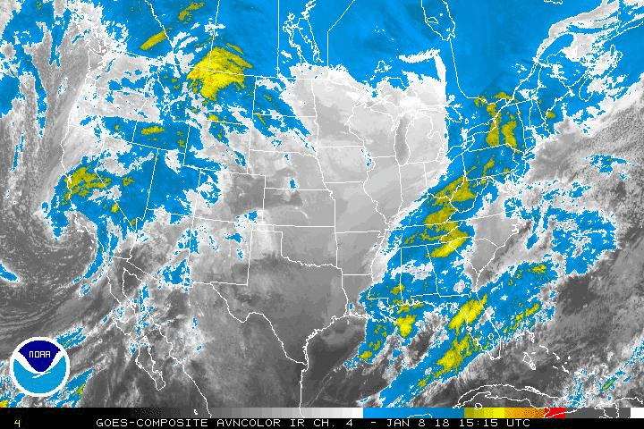
Not related to Texas, but could be historical. Hurricane Odile could make landfall on Baja California as a Category 3/4 hurricane. The central pressure is low for a Category 3 due to lower ambient pressure and larger size.

000
WTPZ35 KNHC 142051
TCPEP5

BULLETIN
HURRICANE ODILE ADVISORY NUMBER 19
NWS NATIONAL HURRICANE CENTER MIAMI FL EP152014
200 PM PDT SUN SEP 14 2014

...MAJOR HURRICANE ODILE EXPECTED TO AFFECT SOUTHERN BAJA CALIFORNIA
TONIGHT AND MONDAY...
...ALL PREPAREDNESS ACTIONS TO PROTECT LIFE AND PROPERTY SHOULD BE
RUSHED TO COMPLETION...

SUMMARY OF 200 PM PDT...2100 UTC...INFORMATION
----------------------------------------------
LOCATION...21.1N 108.9W
ABOUT 330 MI...535 KM WNW OF MANZANILLO MEXICO
ABOUT 140 MI...225 KM SSE OF THE SOUTHERN TIP OF BAJA CALIFORNIA
MAXIMUM SUSTAINED WINDS...125 MPH...205 KM/H
PRESENT MOVEMENT...NNW OR 330 DEGREES AT 15 MPH...24 KM/H
MINIMUM CENTRAL PRESSURE...922 MB...27.23 INCHES


WATCHES AND WARNINGS
--------------------
CHANGES WITH THIS ADVISORY...

NONE.

SUMMARY OF WATCHES AND WARNINGS IN EFFECT...

A HURRICANE WARNING IS IN EFFECT FOR...
* BAJA CALIFORNIA SUR FROM PUNTA ABREOJOS TO LA PAZ

A HURRICANE WATCH IS IN EFFECT FOR...
* THE WEST COAST OF BAJA CALIFORNIA SUR FROM NORTH OF PUNTA ABREOJOS
TO PUNTA EUGENIA.
* THE EAST COAST OF BAJA CALIFORNIA SUR FROM NORTH OF LA PAZ TO
LORETO

A TROPICAL STORM WARNING IS IN EFFECT FOR...
* THE COAST OF MAINLAND MEXICO FROM MANZANILLO TO CABO CORRIENTES
* THE EAST COAST OF BAJA CALIFORNIA SUR FROM NORTH OF LA PAZ TO
SANTA ROSALIA.

A TROPICAL STORM WATCH IS IN EFFECT FOR...
* THE EAST COAST OF THE BAJA CALIFORNIA SUR FROM NORTH OF SANTA
ROSALIA TO BAHIA SAN JUAN BAUTISTA.

A HURRICANE WARNING MEANS THAT HURRICANE CONDITIONS ARE EXPECTED
SOMEWHERE WITHIN THE WARNING AREA BY MONDAY MORNING. PREPARATIONS
TO PROTECT LIFE AND PROPERTY SHOULD BE RUSHED TO COMPLETION.

A HURRICANE WATCH MEANS THAT HURRICANE CONDITIONS ARE POSSIBLE
WITHIN THE WATCH AREA. A WATCH IS TYPICALLY ISSUED 48 HOURS
BEFORE THE ANTICIPATED FIRST OCCURRENCE OF TROPICAL-STORM-FORCE
WINDS...CONDITIONS THAT MAKE OUTSIDE PREPARATIONS DIFFICULT OR
DANGEROUS.

A TROPICAL STORM WARNING MEANS THAT TROPICAL STORM CONDITIONS ARE
EXPECTED SOMEWHERE WITHIN THE WARNING AREA.

A TROPICAL STORM WATCH MEANS THAT TROPICAL STORM CONDITIONS ARE
POSSIBLE WITHIN THE WATCH AREA...GENERALLY WITHIN 48 HOURS.

INTERESTS ELSEWHERE IN THE BAJA CALIFORNIA PENINSULA SHOULD
CONTINUE TO MONITOR THE PROGRESS OF ODILE.

FOR STORM INFORMATION SPECIFIC TO YOUR AREA...PLEASE MONITOR
PRODUCTS ISSUED BY YOUR NATIONAL METEOROLOGICAL SERVICE.


DISCUSSION AND 48-HOUR OUTLOOK
------------------------------
AT 200 PM PDT...2100 UTC...THE CENTER OF THE EYE OF MAJOR HURRICANE
ODILE WAS LOCATED BY AN AIR FORCE RESERVE RECONNAISSANCE AIRCRAFT
NEAR LATITUDE 21.1 NORTH...LONGITUDE 108.9 WEST. ODILE IS MOVING
TOWARD THE NORTH-NORTHWEST NEAR 15 MPH...24 KM/H...AND THIS GENERAL
MOTION IS EXPECTED DURING THE NEXT DAY OR TWO. ON THE FORECAST
TRACK...THE CORE OF ODILE WILL PASS NEAR OR OVER THE SOUTHERN
PORTION OF BAJA CALIFORNIA SUR TONIGHT AND MONDAY.

REPORTS FROM THE RECONNAISSANCE AIRCRAFT INDICATE THAT MAXIMUM
SUSTAINED WINDS ARE NEAR 125 MPH...205 KM/H...WITH HIGHER GUSTS.
ODILE IS A STRONG CATEGORY THREE HURRICANE ON THE SAFFIR-SIMPSON
HURRICANE WIND SCALE. SOME SLIGHT STRENGTHENING IS POSSIBLE
OVERNIGHT...AND ODILE COULD BECOME A CATEGORY FOUR HURRICANE AGAIN
BEFORE IT APPROACHES SOUTHERN BAJA CALIFORNIA SUR. GRADUAL WEAKENING
IS FORECAST TO BEGIN BY MONDAY NIGHT AND CONTINUE INTO TUESDAY.

ODILE IS A LARGE HURRICANE. HURRICANE-FORCE WINDS EXTEND OUTWARD UP
TO 50 MILES...85 KM...FROM THE CENTER...AND TROPICAL-STORM-FORCE
WINDS EXTEND OUTWARD UP TO 185 MILES...295 KM.

THE MINIMUM CENTRAL PRESSURE ESTIMATED FROM HURRICANE HUNTER
AIRCRAFT OBSERVATIONS IS 922 MB...27.23 INCHES.


HAZARDS AFFECTING LAND
----------------------
WIND...HURRICANE CONDITIONS ARE EXPECTED IN THE HURRICANE WARNING
AREA BEGINNING TONIGHT...AND ARE POSSIBLE IN THE HURRICANE WATCH
AREA LATE MONDAY. TROPICAL STORM CONDITIONS ARE EXPECTED TO SPREAD
NORTHWARD ACROSS BAJA CALIFORNIA SUR IN ADVANCE OF THE HURRICANE
CONDITIONS LATER TODAY AND TONIGHT. TROPICAL STORM CONDITIONS ARE
POSSIBLE WITHIN THE TROPICAL STORM WATCH AREA BY MONDAY NIGHT.
TROPICAL STORM CONDITIONS ARE LIKELY STILL OCCURRING ALONG THE COAST
OF MAINLAND MEXICO IN THE WARNING AREA BUT SHOULD BEGIN TO DIMINISH
LATER TONIGHT.

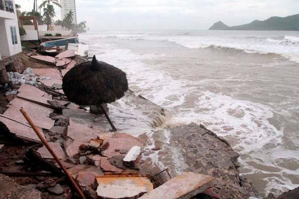
STORM SURGE...A DANGEROUS STORM SURGE IS EXPECTED TO PRODUCE
SIGNIFICANT COASTAL FLOODING IN AREAS OF ONSHORE WINDS IN THE
HURRICANE WARNING AREA. NEAR THE COAST...THE SURGE WILL BE
ACCOMPANIED BY LARGE AND DESTRUCTIVE WAVES.

SURF...SWELLS FROM ODILE WILL AFFECT PORTIONS OF THE SOUTHWESTERN
COAST OF MEXICO DURING THE NEXT COUPLE OF DAYS...AND ARE BEGINNING
TO AFFECT SOUTHERN PORTIONS OF THE BAJA CALIFORNIA PENINSULA AND THE
SOUTHERN GULF OF CALIFORNIA. THESE SWELLS ARE LIKELY TO CAUSE
LIFE-THREATENING SURF AND RIP CURRENT CONDITIONS. PLEASE CONSULT
PRODUCTS FROM YOUR LOCAL WEATHER OFFICE.

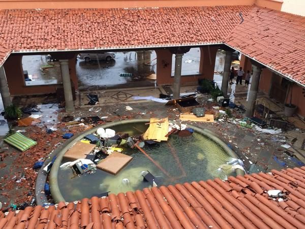
RAINFALL...ODILE IS EXPECTED TO PRODUCE RAINFALL AMOUNTS OF 5 TO 10
INCHES WITH ISOLATED TOTALS OF AROUND 15 INCHES IN BAJA CALIFORNIA
SUR...ESPECIALLY IN MOUNTAINOUS TERRAIN. SOME HEAVIER RAINFALL BANDS
WILL ALSO MOVE THROUGH THE MEXICAN STATES OF COLIMA...WESTERN
JALISCO...AND WESTERN MICHOACAN. THESE RAINS ARE LIKELY TO RESULT IN
LIFE-THREATENING FLASH FLOODS AND MUDSLIDES.


NEXT ADVISORY
-------------
NEXT INTERMEDIATE ADVISORY...500 PM PDT.
NEXT COMPLETE ADVISORY...800 PM PDT.

$$
FORECASTER STEWART

http://www.nhc.noaa.gov/text/refresh/MI ... 2051.shtml
User avatar
srainhoutx
Site Admin
Site Admin
Posts: 19685
Joined: Tue Feb 02, 2010 2:32 pm
Location: Maggie Valley, NC
Contact:

A very complex and complicated forecast is ahead for this week. A very noticeable 500/700 mb vort max associated with a tropical wave axis (once 92L) is moving WNW across the Western Gulf. Powerful Hurricane Odile made landfall in Cabo San Lucas overnight and right of the track guidance and likely will continue heading N along or near the spine of the Baja Peninsula or Gulf of California before weakening and turning NE to ENE wringing out its abundant tropical moisture across Southern Arizona/Southern New Mexico/ Northern Mexico and Texas. Radar returns across the Midland area show moisture spreading E with the remnants of 94L and Odile. Rain chances should increase later today as the wave axis shifts W and we get into the higher moisture values on the back side of the tropical wave. We will need to closely monitor developments this week as I see the potential for flooding like we witnessed in 1994 from EPAC Hurricane Rosa. Expect the forecast to change from day to day. Embedded short wave disturbances tapping tropical moisture and no real cold front to sweep out all the developing pooling of rather high PW's until early next week raise an eyebrow and may lead to a dangerous flood event across portions of the Desert SW/Mexico as well as Texas and the Southern Plains on NE.

Image

Image

Image
Carla/Alicia/Jerry(In The Eye)/Michelle/Charley/Ivan/Dennis/Katrina/Rita/Wilma/Humberto/Ike/Harvey

Member: National Weather Association
Facebook.com/Weather Infinity
Twitter @WeatherInfinity
User avatar
srainhoutx
Site Admin
Site Admin
Posts: 19685
Joined: Tue Feb 02, 2010 2:32 pm
Location: Maggie Valley, NC
Contact:

Afternoon Update from Jeff:

Weak front that brought an unseasonably cool weekend with highs in the 60’s and Saturday and 70’s on Sunday is starting to wash out over the coast waters.

Weak tropical wave (remains of 92L) area progressing into the coastal waters this afternoon and will move onto the TX coast tonight. Pool of tropical moisture on the east side of this wave axis will move inland on Tuesday replacing the dry weather of the recent weekend. Additionally, weak disturbances in the NW flow aloft and weak upper level support in the form of divergence should help instigate showers and thunderstorms from Tuesday through the rest of the week. Seabreeze looks to be the main player each day with its inland march each afternoon providing the extra needed lift in a moist air mass to get storms going. Models are keying in on Tuesday and Thursday as the wettest days, but really there is little pattern chance or air mass difference for the next several days. Thursday might end up featuring a slightly better rain chance as ejecting disturbances out of powerful hurricane Odile (see below) becomes entrained in the upper level flow. Odile looks to weaken over NW MX late this week and could provide mid and upper level moisture into the SW US and TX during this time period.

Hurricane Odile:
The strongest hurricane to strike Baja California since 1967 made landfall at Cabo San Lucas overnight with sustained winds of 125mph. Damage to the resorts, hotels, and airport is extensive. The reporting station at the airport recorded a sustained wind of 89mph with gust to 116mph and a pressure of 28.32 in before the site failed.


Image

Image

Image
Carla/Alicia/Jerry(In The Eye)/Michelle/Charley/Ivan/Dennis/Katrina/Rita/Wilma/Humberto/Ike/Harvey

Member: National Weather Association
Facebook.com/Weather Infinity
Twitter @WeatherInfinity
User avatar
jasons2k
Posts: 5861
Joined: Thu Feb 04, 2010 12:54 pm
Location: Imperial Oaks
Contact:

Tidbit from today's NWS-HGX discussion, while it sounds encouraging, I'm just not going to fall for it this time. I HOPE I'm wrong hehe:

HIGH END CHANCE TO LIKELY POPS WILL BE IN THE FORECAST FOR THE AREA TUESDAY THROUGH THURSDAY...AND THINK ALMOST EVERYONE WILL SEE SOME RAIN AT LEAST ONCE OVER THE NEXT THREE DAYS.
User avatar
srainhoutx
Site Admin
Site Admin
Posts: 19685
Joined: Tue Feb 02, 2010 2:32 pm
Location: Maggie Valley, NC
Contact:

A tropical wave axis (former 92L) is moving inland and very high PW's near 2.4 inches + are spreading NW across the Gulf toward Texas. Once power Hurricane Odile is moving N as a Tropical Storm along the Baja Peninsula and should turn ENE and spread its moisture across Northern Mexico/SE Arizona/Southern New Mexico and Texas this week. Embedded short wave disturbances riding in the WNW flow aloft and increased tropical moisture from the SE flow off the Gulf should set the stage for a potential widespread rain event. The fly in the ointment is the slow movement expected from any showers/storms and if we see training set up, the Flood concern may increase. Another issue is newly upgraded Eastern Pacific TS Polo. It may follow a similar track of Odile, so we probably should monitor that system for additional tropical moisture. It appears a cold front may arrive late of Sunday and finally sweep all the unsettled weather off to the E, but timing issues this far out are always an uncertainty.
09162014 09Z GULF_latest.gif
09162014 10Z 7 Day QPF p168i.gif
You do not have the required permissions to view the files attached to this post.
Carla/Alicia/Jerry(In The Eye)/Michelle/Charley/Ivan/Dennis/Katrina/Rita/Wilma/Humberto/Ike/Harvey

Member: National Weather Association
Facebook.com/Weather Infinity
Twitter @WeatherInfinity
User avatar
srainhoutx
Site Admin
Site Admin
Posts: 19685
Joined: Tue Feb 02, 2010 2:32 pm
Location: Maggie Valley, NC
Contact:

Morning Update from Jeff:

Tropical air mass working its way back into the region along with moisture from TS Odile.

Various weather making systems will produce an extended period of unsettled wet weather across much of TX this week into the weekend. Surface trough along the TX coast will be moving slowly inland today with deep tropical moisture noted over much of the central and western Gulf of Mexico. Soundings from CRP, BRO, and LCH all recorded PWS above 2.0 inches as tropical moisture from both the Gulf and TS Odile spread across the state. There is no well defined surface focus (front) to organize rainfall with the exception of the surface trough laying along the coast with favorable speed convergence near this feature. Thus rainfall will be mainly daytime heating driven and fall into the usual pattern of coastal nocturnal development in the 200am to 600am period and then spreading inland between 700am and 1000am.

TS Odile is currently moving up the Baja of Mexico this morning and has surprisingly maintained a well defined structure even while interacting with mountains upwards of 3000-5000 ft. Odile will be turning NNE and NE crossing the Gulf of California and then into the state of Arizona. A large shield of mid and high level moisture is peeling off Odile and spreading ENE across much of TX along with embedded energy ejecting outward from the decaying tropical system. Disturbances and additional moisture will only help to foster widespread rainfall and heavier rainfall across the state over the next 48-72 hours as Odile weakens. While this is typically a favorable fall flood setup for TX, the lack of a defined surface front however should negate training organized excessive rainfall.

With that said PWS in the 2.0-2.2 inch range for the next several days will support high hourly rainfall rates on the order of 2-3 inches. HPC grids have a fairly widespread 1-2 inch bullseye over the central and SW sections of SE TX on Wednesday as a disturbance aloft interacts with the tropical plume. Rainfall amounts through the end of the week will likely average 1-2 inches with isolated amounts of 5 inches or higher possible.

Late in the weekend another cold front will approach from the north and likely pass through the region. Will need to be watching newly formed TS Polo off the MX west coast as this system could become entangled with the trough and front late in the weekend.

Carla/Alicia/Jerry(In The Eye)/Michelle/Charley/Ivan/Dennis/Katrina/Rita/Wilma/Humberto/Ike/Harvey

Member: National Weather Association
Facebook.com/Weather Infinity
Twitter @WeatherInfinity
Post Reply
  • Information