
More cold air on the way next week!?
-
srainhoutx

- Site Admin

- Posts: 19700
- Joined: Tue Feb 02, 2010 2:32 pm
- Location: Maggie Valley, NC
- Contact:
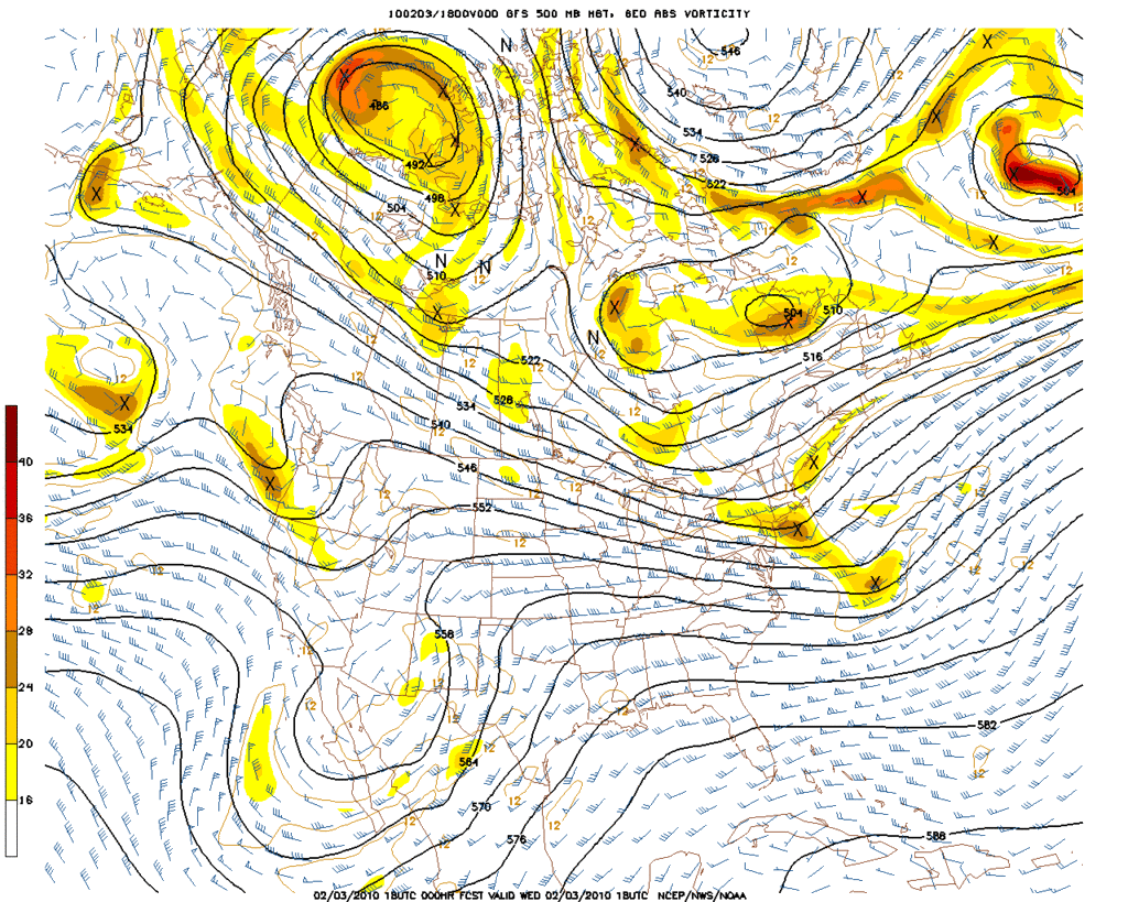
18Z GFS has started...  Cool to have pics isn't it...
Carla/Alicia/Jerry(In The Eye)/Michelle/Charley/Ivan/Dennis/Katrina/Rita/Wilma/Humberto/Ike/Harvey
Member: National Weather Association
Facebook.com/Weather Infinity
Twitter @WeatherInfinity
Member: National Weather Association
Facebook.com/Weather Infinity
Twitter @WeatherInfinity
-
don

- Posts: 3148
- Joined: Wed Feb 03, 2010 3:33 pm
- Location: Wichita Falls
- Contact:
18z looks nice


-
Portastorm

- Posts: 800
- Joined: Wed Feb 03, 2010 3:04 pm
- Location: Southwest Austin/Oak Hill, TX
- Contact:
I really see the event next week (late next week that is) being a lot like the current ongoing event in south Texas ... except the surface temps should be 10-15 degrees colder in many spots. Isentropic lift and overrunning will get heavier as we see surface low development off the coast. Perhaps several days of precip?! Maybe.
Blast away ... but those are my thoughts at the moment.
Blast away ... but those are my thoughts at the moment.
-
don
- Posts: 3148
- Joined: Wed Feb 03, 2010 3:33 pm
- Location: Wichita Falls
- Contact:
Yep GFS shows a ice storm for us folks in southeast texas with snow further off to the north and west in central Texas of course its to far off to be speculating on precip types,but it is hard to ignore the consistency of the GFS and also how the event keeps pushing upward in time instead of backwards like we see alot with the models when they show an fantasy storm that ends up not verifying.For what its worth...
-
Baseballdude2915
- Posts: 192
- Joined: Wed Feb 03, 2010 5:21 pm
- Location: Dickinson, Tx
- Contact:
Interesting to say the least. Still a LONG time for our possible Pre-Valentines ice storm..don wrote:Yep GFS shows a ice storm for us folks in southeast texas with snow further off to the north and west in central Texas of course its to far off to be speculating on precip types,but it is hard to ignore the consistency of the GFS and also how the event keeps pushing upward in time instead of backwards like we see alot with the models when they show an fantasy storm that ends up not verifying.For what its worth...
-
sambucol

- Posts: 1244
- Joined: Wed Feb 03, 2010 5:43 pm
- Location: Mont Belvieu
- Contact:
Are we looking at temps like we had in the January cold event?
-
Ptarmigan

- Statistical Specialist

- Posts: 4519
- Joined: Wed Feb 03, 2010 7:20 pm
- Contact:
According to the GFS data for the next 16 days, it will get cold next Thursday.
http://wxweb.meteostar.com/sample/sampl ... ?text=kiah
http://wxweb.meteostar.com/sample/sampl ... ?text=kiah
-
wxdata

- Site Admin
- Posts: 1059
- Joined: Wed Feb 03, 2010 3:04 pm
- Location: Houston, TX
- Contact:
I'm thinking more late next week than this Monday for any possibility at all.
-
srainhoutx
- Site Admin
- Posts: 19700
- Joined: Tue Feb 02, 2010 2:32 pm
- Location: Maggie Valley, NC
- Contact:
Larry Cosgrove tonight in the Houston Examiner...
http://www.examiner.com/x-3775-Houston- ... ary-4-2010
http://www.examiner.com/x-3775-Houston- ... ary-4-2010
Carla/Alicia/Jerry(In The Eye)/Michelle/Charley/Ivan/Dennis/Katrina/Rita/Wilma/Humberto/Ike/Harvey
Member: National Weather Association
Facebook.com/Weather Infinity
Twitter @WeatherInfinity
Member: National Weather Association
Facebook.com/Weather Infinity
Twitter @WeatherInfinity
-
Gene Norman
GFS has been back and forth on this. I'm sold on the cold, but think Monday's rain will exit before the artic push makes it. However, a good argument could be made for over-running Wednesday and if the cold air is still in place as the next push of moisture arrives Thursday, then it could get interesting indeed. Stay tuned.
-
srainhoutx
- Site Admin
- Posts: 19700
- Joined: Tue Feb 02, 2010 2:32 pm
- Location: Maggie Valley, NC
- Contact:
Thanks Gene. Good to see you back and hope we hear from all of our fine Pro's.Gene Norman wrote:GFS has been back and forth on this. I'm sold on the cold, but think Monday's rain will exit before the artic push makes it. However, a good argument could be made for over-running Wednesday and if the cold air is still in place as the next push of moisture arrives Thursday, then it could get interesting indeed. Stay tuned.
Carla/Alicia/Jerry(In The Eye)/Michelle/Charley/Ivan/Dennis/Katrina/Rita/Wilma/Humberto/Ike/Harvey
Member: National Weather Association
Facebook.com/Weather Infinity
Twitter @WeatherInfinity
Member: National Weather Association
Facebook.com/Weather Infinity
Twitter @WeatherInfinity
-
srainhoutx
- Site Admin
- Posts: 19700
- Joined: Tue Feb 02, 2010 2:32 pm
- Location: Maggie Valley, NC
- Contact:
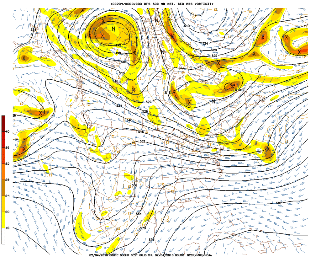
00Z GFS has started..I suppect the "night crew" will be busy tonight...enjoy the Forum folks...
Carla/Alicia/Jerry(In The Eye)/Michelle/Charley/Ivan/Dennis/Katrina/Rita/Wilma/Humberto/Ike/Harvey
Member: National Weather Association
Facebook.com/Weather Infinity
Twitter @WeatherInfinity
Member: National Weather Association
Facebook.com/Weather Infinity
Twitter @WeatherInfinity
-
wxdata
- Site Admin
- Posts: 1059
- Joined: Wed Feb 03, 2010 3:04 pm
- Location: Houston, TX
- Contact:
Agreed. GFS is less sure of any frozen precip at least this far south (and at least for this run)

-
txsnowmaker
- Posts: 733
- Joined: Wed Feb 03, 2010 4:07 pm
- Location: SW Houston (Galleria area)
- Contact:
The predicted back and forth known otherwise known as the medium-long range GFS continues. Hopefully the shift of the freezing line further west and north of our area for late next week is only a temporary blip.
-
Andrew
- Site Admin
- Posts: 3508
- Joined: Wed Feb 03, 2010 9:46 pm
- Location: North-West Houston
- Contact:
I will be happy once all this cold air gets out of here and temps are back into the 90's. Bring on the heat!txsnowmaker wrote:The predicted back and forth known otherwise known as the medium-long range GFS continues. Hopefully the shift of the freezing line further west and north of our area for late next week is only a temporary blip.
For Your Infinite Source For All Things Weather Visit Our Facebook
-
TexasMetBlake
- Pro Met

- Posts: 839
- Joined: Wed Feb 03, 2010 7:03 pm
- Location: Spring/Woodlands
- Contact:
Come on guys! We have heat 15 months out of the year. Now that it's February, winter is on the downswing. Let us have our last little horah here and you can have all the heat you can boil in....Andrew wrote:I will be happy once all this cold air gets out of here and temps are back into the 90's. Bring on the heat!txsnowmaker wrote:The predicted back and forth known otherwise known as the medium-long range GFS continues. Hopefully the shift of the freezing line further west and north of our area for late next week is only a temporary blip.
-
don
- Posts: 3148
- Joined: Wed Feb 03, 2010 3:33 pm
- Location: Wichita Falls
- Contact:
Even though the 0z is a Little warmer its not significantly, it still shows temps in the mid to low 30's with precip for what its worth.
http://wxweb.meteostar.com/sample/sampl ... ?text=KDWH
http://wxweb.meteostar.com/sample/sampl ... ?text=KDWH
-
Andrew
- Site Admin
- Posts: 3508
- Joined: Wed Feb 03, 2010 9:46 pm
- Location: North-West Houston
- Contact:
Haha i know i know. I just hate the cold if it is not snowing. The cold is useless without precip. At least with heat plants can grow etc... The GFS has been painting at least a change of wintry precip so don't be so disappointed.Candy Cane wrote:Come on guys! We have heat 15 months out of the year. Now that it's February, winter is on the downswing. Let us have our last little horah here and you can have all the heat you can boil in....Andrew wrote:I will be happy once all this cold air gets out of here and temps are back into the 90's. Bring on the heat!txsnowmaker wrote:The predicted back and forth known otherwise known as the medium-long range GFS continues. Hopefully the shift of the freezing line further west and north of our area for late next week is only a temporary blip.
For Your Infinite Source For All Things Weather Visit Our Facebook
-
- Information
-
Who is online
Users browsing this forum: Bing [Bot], Stratton20, TexasBreeze and 2 guests