
Post Tropical Cyclone Debby. Exiting E Over The Atlantic
-
cisa
- Posts: 249
- Joined: Fri Feb 05, 2010 10:43 pm
- Location: Porter, TX
- Contact:
Thanks again Andrew.
No rain, no rainbows.
-
Belmer

- Global Moderator

- Posts: 745
- Joined: Thu Jan 06, 2011 7:29 pm
- Location: Dallas, TX
- Contact:
I know we won't know probably till the day before landfall where this system will land. But how long will we know that Debby for sure won't be picked up by the trough? In other words, when is the trough suppose to be far enough to the north/east where we know it wont pick Debby up?
Blake
Boomer Sooner
Boomer Sooner
-
Andrew
- Site Admin

- Posts: 3508
- Joined: Wed Feb 03, 2010 9:46 pm
- Location: North-West Houston
- Contact:
We should know by tomorrow night.Belmer wrote:I know we won't know probably till the day before landfall where this system will land. But how long will we know that Debby for sure won't be picked up by the trough? In other words, when is the trough suppose to be far enough to the north/east where we know it wont pick Debby up?
For Your Infinite Source For All Things Weather Visit Our Facebook
-
cisa
- Posts: 249
- Joined: Fri Feb 05, 2010 10:43 pm
- Location: Porter, TX
- Contact:
And if Euro picks it up, do you think HPC will change the forecast?
No rain, no rainbows.
-
Andrew
- Site Admin
- Posts: 3508
- Joined: Wed Feb 03, 2010 9:46 pm
- Location: North-West Houston
- Contact:
If the Euro goes Florida they would probably change it or at least heavily note it. At the same time though we are getting to that point where you "nowcast" This thing is still only barely moving north so only time will really tell.cisa wrote:And if Euro picks it up, do you think HPC will change the forecast?
For Your Infinite Source For All Things Weather Visit Our Facebook
-
TexasBreeze
- Posts: 1026
- Joined: Sun Sep 26, 2010 4:46 pm
- Location: NW Houston, TX
- Contact:
I think the gfs may about to score a major coup...
-
cisa
- Posts: 249
- Joined: Fri Feb 05, 2010 10:43 pm
- Location: Porter, TX
- Contact:
Thanks again. I'll see you guys tomorrow. Nite.
No rain, no rainbows.
-
Scott747
- Posts: 1648
- Joined: Tue Feb 23, 2010 9:56 am
- Location: Freeport/Surfside Beach
- Contact:
FWIW the ECMWF (Euro) was just upgraded on the 19th -
http://www.ecmwf.int/products/changes/ifs_cycle_38r1/
And for the poster that was asking about what the best model was. Here is the verification statistics from last year if interested -
http://www.nhc.noaa.gov/verification/pd ... n_2011.pdf
http://www.ecmwf.int/products/changes/ifs_cycle_38r1/
And for the poster that was asking about what the best model was. Here is the verification statistics from last year if interested -
http://www.nhc.noaa.gov/verification/pd ... n_2011.pdf
-
djmike

- Posts: 1875
- Joined: Fri Jan 07, 2011 12:19 pm
- Location: BEAUMONT, TX
- Contact:
C'mon Euro! I'm rootin for ya!
Mike
Beaumont, TX
(IH-10 & College Street)
Beaumont, TX
(IH-10 & College Street)
-
Andrew
- Site Admin
- Posts: 3508
- Joined: Wed Feb 03, 2010 9:46 pm
- Location: North-West Houston
- Contact:
TexasBreeze wrote:I think the gfs may about to score a major coup...
That is the thing though the GFS isn't right. It could show the possible right solution but how it does it is wrong. It is having feedback issues in the model. The black and white CMC isn't really detailed enough for me to see how it gets picked up but right now I would completely through it out. To be honest the NAM looks better then the gfs right now.
For Your Infinite Source For All Things Weather Visit Our Facebook
-
Rip76

- Posts: 2126
- Joined: Mon Feb 15, 2010 12:38 am
- Location: The Woodlands
- Contact:
Texas Breeze, I agree fully.
-
biggerbyte
- Posts: 1437
- Joined: Thu Feb 04, 2010 12:15 am
- Location: Porter, Texas. (Montgomery County)
- Contact:
We need the rain so bad. It just can't get picked up and sent away. I'm still with Jeff on this until the Euro comes in.
-
Scott747
- Posts: 1648
- Joined: Tue Feb 23, 2010 9:56 am
- Location: Freeport/Surfside Beach
- Contact:
In instances like this when the storm isn't completely stacked and the llc is exposed many people will understandably follow the blob and assume a change in course. I'll admit I was a bit surprised that the NHC had in fact gained confidence in their forecast and Stewart made a great case why.
Now does that mean we won't see a potential reformation to the NE or even movement further N, of course not. There has been a trend though with the models to the right with the last few runs. HWRF and GFDL are up in a few min. Will be interesting to see if they have any more of a change.
Now does that mean we won't see a potential reformation to the NE or even movement further N, of course not. There has been a trend though with the models to the right with the last few runs. HWRF and GFDL are up in a few min. Will be interesting to see if they have any more of a change.
-
Scott747
- Posts: 1648
- Joined: Tue Feb 23, 2010 9:56 am
- Location: Freeport/Surfside Beach
- Contact:
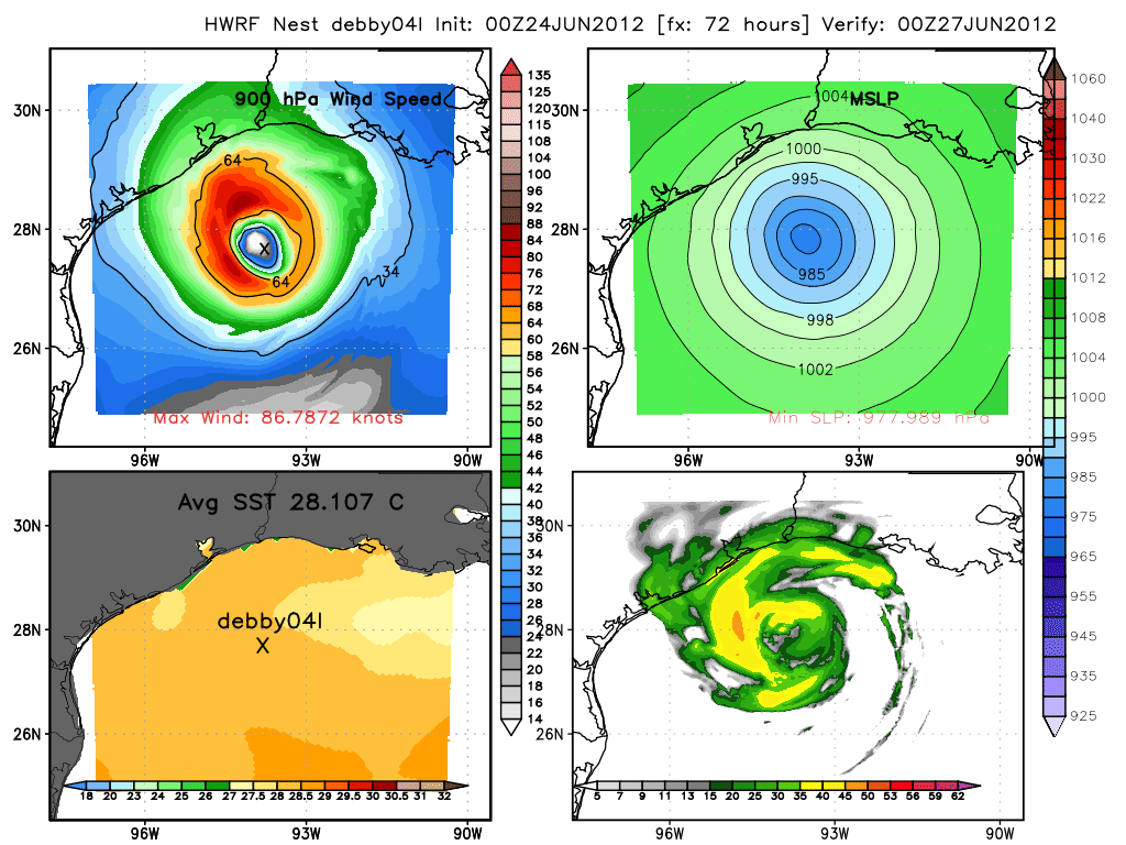
In the case of the HWRF that answer would be no. In fact it shifted somewhat to the S through hr 72 -
-
Andrew
- Site Admin
- Posts: 3508
- Joined: Wed Feb 03, 2010 9:46 pm
- Location: North-West Houston
- Contact:
THis link was posted earlier but you can still see that the llc is exposed and is stalled.
http://www.srh.noaa.gov/tropical/satpix ... s_loop.php
http://www.srh.noaa.gov/tropical/satpix ... s_loop.php
For Your Infinite Source For All Things Weather Visit Our Facebook
-
jean1968

- Posts: 2
- Joined: Sat Feb 20, 2010 11:31 pm
- Location: Pasadena, TX
- Contact:
I never post, so just be gentle....  My question is, if it does hit between Corpus and Madagorda...wouldn't we get some nasty weather (aren't we on the "dirty" side)? The storm appears (to a novice anyway) to be quite large. Also, after it comes ashore somewhere will it continue west or go more northwest???
Feel free to make any corrections or just point out flaws in my logic...lol
Jean
Feel free to make any corrections or just point out flaws in my logic...lol
Jean
-
biggerbyte
- Posts: 1437
- Joined: Thu Feb 04, 2010 12:15 am
- Location: Porter, Texas. (Montgomery County)
- Contact:
I'm still seeing what Jeff and Wxman57 have been saying. Westward with a southern component. That is the most logical solution. I'm done with model flipping at the moment. We need to gather more data, and give this until at least Sunday evening before making any major changes in thinking. This is in spite of what the models are saying until then. With every flip, there is a flop.
-
Andrew
- Site Admin
- Posts: 3508
- Joined: Wed Feb 03, 2010 9:46 pm
- Location: North-West Houston
- Contact:
You are correct. If the storm does hit the middle Texas coast we would be looking at heavy rains, some wind, and above average tides. Consolidation of the storms would be possible though. After it comes ashore it should continue Northwest and not as much west. As a result even if it hit the middle to lower coast we would still get a lot of activity here locally.jean1968 wrote:I never post, so just be gentle....
Feel free to make any corrections or just point out flaws in my logic...lol
Jean
For Your Infinite Source For All Things Weather Visit Our Facebook