
More cold air on the way next week!?
-
srainhoutx

- Site Admin

- Posts: 19700
- Joined: Tue Feb 02, 2010 2:32 pm
- Location: Maggie Valley, NC
- Contact:
As well you should Portastorm. Some rather interesting changes overnight from the HPC. They are now suggesting the GFS as the perferred guidance and the ECMWF is now the outlier. Could get rather interesting for some folks as the storm digs deeper S along the Baja and also becomes stronger. We shall see. Regardless, our couple of days with some sun and warmer temps are now a thing of the past. Oh and for wman57, Geaux Saints!
Carla/Alicia/Jerry(In The Eye)/Michelle/Charley/Ivan/Dennis/Katrina/Rita/Wilma/Humberto/Ike/Harvey
Member: National Weather Association
Facebook.com/Weather Infinity
Twitter @WeatherInfinity
Member: National Weather Association
Facebook.com/Weather Infinity
Twitter @WeatherInfinity
-
sleetstorm
- Posts: 651
- Joined: Thu Feb 04, 2010 12:33 pm
- Contact:
Never say neverr SCSLAND and Cloud2ground because you never know.  I concur with Portastorm. We may not know what to anticipate as far as temperatures and precipitation until tomorrow, Tuesday, or Wednesday, or even the day of the event itself.
  I am praying that southeast Texas does in fact get much in the way of sleet/rain snow mix, although all snow would be excellent.
-
Portastorm

- Posts: 800
- Joined: Wed Feb 03, 2010 3:04 pm
- Location: Southwest Austin/Oak Hill, TX
- Contact:
I'm with ya sleet!sleetstorm wrote:Never say neverr SCSLAND and Cloud2ground because you never know.
-
sleetstorm
- Posts: 651
- Joined: Thu Feb 04, 2010 12:33 pm
- Contact:
It seems as though SE Texas just might receive sleet/rain snow mix especially if that area of low pressure contiues to dig further south like it has been doing for the past several days now, right srainhoutx?srainhoutx wrote:As well you should Portastorm. Some rather interesting changes overnight from the HPC. They are now suggesting the GFS as the perferred guidance and the ECMWF is now the outlier. Could get rather interesting for some folks as the storm digs deeper S along the Baja and also becomes stronger. We shall see. Regardless, our couple of days with some sun and warmer temps are now a thing of the past. Oh and for wman57, Geaux Saints!
-
srainhoutx
- Site Admin
- Posts: 19700
- Joined: Tue Feb 02, 2010 2:32 pm
- Location: Maggie Valley, NC
- Contact:
We will see sleet. Still an aweful lot of model runs to go before anyone will know with any certainty how things will play out. The storm we are talking about is still in the Pacific and not onshore. But as wxman57 told you last week, don't give up hope!
Carla/Alicia/Jerry(In The Eye)/Michelle/Charley/Ivan/Dennis/Katrina/Rita/Wilma/Humberto/Ike/Harvey
Member: National Weather Association
Facebook.com/Weather Infinity
Twitter @WeatherInfinity
Member: National Weather Association
Facebook.com/Weather Infinity
Twitter @WeatherInfinity
-
sleetstorm
- Posts: 651
- Joined: Thu Feb 04, 2010 12:33 pm
- Contact:
I am certain that most everyone on this weather forum wants winter fun but they just do not want to be let down by not getting any frozen precip. at all & I totally understand that. The computer models are just not having much in the way of consensus.
-
srainhoutx
- Site Admin
- Posts: 19700
- Joined: Tue Feb 02, 2010 2:32 pm
- Location: Maggie Valley, NC
- Contact:
RE the 12Z runs...
NCEP Operational Status Message
Sun Feb 7 13:32:40 2010 GMT
NOUS42 KWNO 071332
ADMNFD
SENIOR DUTY METEOROLOGIST NWS ADMINISTRATIVE MESSAGE
NWS NCEP CENTRAL OPERATIONS CAMP SPRINGS MD
1329Z SUN FEB 07 2010
12Z NCEP MODEL CYCLE STARTED ON TIME. NO 12Z MEXICAN REPORTS
WERE RECEIVED AS YET. DATA COVERAGE INCLUDED...14 AK/32
CANADIAN/71 CONUS AND 6 CARIBBEAN REPORTS IN TIME FOR THE
NAM START.
12Z NAM RAOB RECAP...
DRA/72387 - UNAVAILABLE ON WEEKENDS/HOLIDAYS
KCR/78384 - DELETED TEMPS 840-695MB...WET BULB EFFECT.
KPB/78954 - DELETED WINDS 176MB AND ABV...ERRATIC.
CWD IN EFFECT UNTIL 02/08/12Z.
$$
WOOLDRIDGE/SDM/NCO/NCEP
Carla/Alicia/Jerry(In The Eye)/Michelle/Charley/Ivan/Dennis/Katrina/Rita/Wilma/Humberto/Ike/Harvey
Member: National Weather Association
Facebook.com/Weather Infinity
Twitter @WeatherInfinity
Member: National Weather Association
Facebook.com/Weather Infinity
Twitter @WeatherInfinity
-
txsnowmaker
- Posts: 733
- Joined: Wed Feb 03, 2010 4:07 pm
- Location: SW Houston (Galleria area)
- Contact:
Ch. 13 currently has Houston at 34 overnight on Wednesday. With the recent temperature busts, hopefully the models are still undercutting the system's impact. For example, is the GFS really factoring in the existing and forecasted snow cover to our north--shouldn't there still be enough to impact modification? We will find out with certainty soon enough.
-
srainhoutx
- Site Admin
- Posts: 19700
- Joined: Tue Feb 02, 2010 2:32 pm
- Location: Maggie Valley, NC
- Contact:
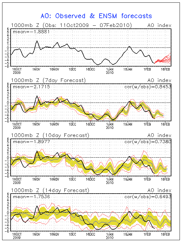
In keeping with the theme of this Topic, AO is below -5.000 which marks the third time since 1950. What is also noteworthy and very interesting is that December 2009-February 2010 is the first case we have recorded AO at -5.000 or below in three consectutive months. Long range ensembles continue to suggest that AO will remain negative to severely negative for some time to come as well.
Carla/Alicia/Jerry(In The Eye)/Michelle/Charley/Ivan/Dennis/Katrina/Rita/Wilma/Humberto/Ike/Harvey
Member: National Weather Association
Facebook.com/Weather Infinity
Twitter @WeatherInfinity
Member: National Weather Association
Facebook.com/Weather Infinity
Twitter @WeatherInfinity
-
wxman57

- Global Moderator

- Posts: 2621
- Joined: Thu Feb 04, 2010 5:34 am
- Location: Southwest Houston (Westbury)
- Contact:
Well, I'm encouraged in that the models seem to be converging on a single solution for next Thu-Fri now, and at least the GFS is NOT making a very common mistake with such a pattern. The pattern that they're all converging on is a southern stream shortwave moving across Texas. Though some models have it passing farther north, others farther south, they all have a feature of similar strength now.
It's a common setup for another West Gulf Low (WGL). This one doesn't look strong, just your run-of-the-mill WGL bordering on just a wave. Such lows will drive significant moisture inland across Texas/Louisiana as they develop, producing widespread stratiform precipitation. The precipitation shield is where the models often have trouble. Since the source of the moisture will always be the Gulf of Mexico, the heaviest precipitation is confined to coastal counties with diminishing amounts inland. Remember last week that the models had heaviest precipitation across north TX and OK? Now, at least the GFS and ECMWF shift the heavier precip down south. That means the areas with the coldest air get the least precipitation. It's a reasonable solution.
So I'm beginning to trust the GFS a bit more with its latest solution. I ran some meteograms (below). Moderate lower-level warm advection across coastal sections of Texas should mean that we'll see a cold rain down here (temps in the upper 30s or so). Might be a few sleet pellets when the precip is coming to an end as the low moves off to the east on Friday. Farther north in Dallas, very little precip is indicated, but temps are cold enough for at least some frozen precip. West to Austin looks like more cold rain, a bit colder than in Houston, but mostly rain. Could be a bit of sleet mixed in as the precip winds down on Friday.
I'm becoming more confident that we won't see a significant winter storm in Texas with this event because the airmass is just a tad too warm. It's a close call, though, and I certainly wouldn't rule out some significant winter weather in Texas yet with the event 4-5 days away. The low could form north of the Gulf, and that would mean more moisture farther north.
Houstin (IAH) 00Z GFS Meteogram

Austin 00Z GFS Meteogram

Dallas-Ft. Worth 00Z GFS Meteogram

It's a common setup for another West Gulf Low (WGL). This one doesn't look strong, just your run-of-the-mill WGL bordering on just a wave. Such lows will drive significant moisture inland across Texas/Louisiana as they develop, producing widespread stratiform precipitation. The precipitation shield is where the models often have trouble. Since the source of the moisture will always be the Gulf of Mexico, the heaviest precipitation is confined to coastal counties with diminishing amounts inland. Remember last week that the models had heaviest precipitation across north TX and OK? Now, at least the GFS and ECMWF shift the heavier precip down south. That means the areas with the coldest air get the least precipitation. It's a reasonable solution.
So I'm beginning to trust the GFS a bit more with its latest solution. I ran some meteograms (below). Moderate lower-level warm advection across coastal sections of Texas should mean that we'll see a cold rain down here (temps in the upper 30s or so). Might be a few sleet pellets when the precip is coming to an end as the low moves off to the east on Friday. Farther north in Dallas, very little precip is indicated, but temps are cold enough for at least some frozen precip. West to Austin looks like more cold rain, a bit colder than in Houston, but mostly rain. Could be a bit of sleet mixed in as the precip winds down on Friday.
I'm becoming more confident that we won't see a significant winter storm in Texas with this event because the airmass is just a tad too warm. It's a close call, though, and I certainly wouldn't rule out some significant winter weather in Texas yet with the event 4-5 days away. The low could form north of the Gulf, and that would mean more moisture farther north.
Houstin (IAH) 00Z GFS Meteogram
Austin 00Z GFS Meteogram
Dallas-Ft. Worth 00Z GFS Meteogram
-
sleetstorm
- Posts: 651
- Joined: Thu Feb 04, 2010 12:33 pm
- Contact:
I have not relinquished any hope it is just waiting and the suspense that makes all of this all the more interesting.srainhoutx wrote:We will see sleet. Still an aweful lot of model runs to go before anyone will know with any certainty how things will play out. The storm we are talking about is still in the Pacific and not onshore. But as wxman57 told you last week, don't give up hope!
-
wxman57
- Global Moderator
- Posts: 2621
- Joined: Thu Feb 04, 2010 5:34 am
- Location: Southwest Houston (Westbury)
- Contact:
I certainly wouldn't rule out a few sleet pellets with the event. Just don't expect to wake up with a sleet-covered ground Friday morning. Any sleet that does fall would last just a few seconds before melting.sleetstorm wrote:I have not relinquished any hope it is just waiting and the suspense that makes all of this all the more interesting.srainhoutx wrote:We will see sleet. Still an aweful lot of model runs to go before anyone will know with any certainty how things will play out. The storm we are talking about is still in the Pacific and not onshore. But as wxman57 told you last week, don't give up hope!
-
srainhoutx
- Site Admin
- Posts: 19700
- Joined: Tue Feb 02, 2010 2:32 pm
- Location: Maggie Valley, NC
- Contact:
RE the 12Z GFS...RECON data from the G-IV flight is included...
NCEP Operational Status Message
Sun Feb 7 14:52:38 2010 GMT
NOUS42 KWNO 071450
ADMNFD
SENIOR DUTY METEOROLOGIST NWS ADMINISTRATIVE MESSAGE
NWS NCEP CENTRAL OPERATIONS CAMP SPRINGS MD
1447Z SUN FEB 07 2010
NO MEXICAN REPORTS WERE RECEIVED FOR THE GFS EITHER. BUT IN
ANY CASE THE NCEP MODEL CYCLE IS RUNNING SMOOTHLY AND IS ON
TIME.
12Z GFS RAOB RECAP...
RECON A/C REPORT IN SUPPORT OF WSR...
16 DROPSONDES WERE RECEIVED FROM THE NOAA G-IV FROM THE
WESTPAC REGION.
CWD IN EFFECT UNTIL 02/08/12Z.
$$
WOOLDRIDGE/SDM/NCO/NCEP
Carla/Alicia/Jerry(In The Eye)/Michelle/Charley/Ivan/Dennis/Katrina/Rita/Wilma/Humberto/Ike/Harvey
Member: National Weather Association
Facebook.com/Weather Infinity
Twitter @WeatherInfinity
Member: National Weather Association
Facebook.com/Weather Infinity
Twitter @WeatherInfinity
-
Portastorm
- Posts: 800
- Joined: Wed Feb 03, 2010 3:04 pm
- Location: Southwest Austin/Oak Hill, TX
- Contact:
After a quick perusal at the 12z GFS run, it appears to my untrained eye that the run is a little stronger, slower, and further south (a tad) than the 0z run with the upper level storm coming our way.
-
kayci

- Posts: 358
- Joined: Thu Feb 04, 2010 10:30 am
- Location: Alvin
- Contact:
Translation please... re: freeze. I live in Texas City, will I need to cover my plants again this week?
-
Portastorm
- Posts: 800
- Joined: Wed Feb 03, 2010 3:04 pm
- Location: Southwest Austin/Oak Hill, TX
- Contact:
I doubt it will get below freezing in Texas City this coming week.kayci wrote:Translation please... re: freeze. I live in Texas City, will I need to cover my plants again this week?
-
wxman57
- Global Moderator
- Posts: 2621
- Joined: Thu Feb 04, 2010 5:34 am
- Location: Southwest Houston (Westbury)
- Contact:
And I agree, Portastorm. Maybe upper 30s in Texas City. Miserable cold rain won't hurt the plants.Portastorm wrote:I doubt it will get below freezing in Texas City this coming week.kayci wrote:Translation please... re: freeze. I live in Texas City, will I need to cover my plants again this week?
-
srainhoutx
- Site Admin
- Posts: 19700
- Joined: Tue Feb 02, 2010 2:32 pm
- Location: Maggie Valley, NC
- Contact:
Folks from Del Rio to Austin, College Station and points E and N may have some issues with wintery precip if the 12Z GFS is correct. A long way to go just yet and we know things will change several times between now and Friday, but bears watching IMHO.
Carla/Alicia/Jerry(In The Eye)/Michelle/Charley/Ivan/Dennis/Katrina/Rita/Wilma/Humberto/Ike/Harvey
Member: National Weather Association
Facebook.com/Weather Infinity
Twitter @WeatherInfinity
Member: National Weather Association
Facebook.com/Weather Infinity
Twitter @WeatherInfinity
-
wxman57
- Global Moderator
- Posts: 2621
- Joined: Thu Feb 04, 2010 5:34 am
- Location: Southwest Houston (Westbury)
- Contact:
Three words for Houston later this week - Cold Miserable Rain
12Z GFS is in, and there are differences from 00Z and 06Z. However, I think that those differences may be going in the wrong direction, accuracy-wise. I'd mentioned that 00Z and 06Z GFS weren't making a common error of positioning the max moisture well inland. It appears the 12Z GFS may be making that mistake. The 12Z GFS has much more moisture in the Austin-Dallas area than the previous 2 runs. It would be unusual for a frontal wave/low in the Gulf to have so much heavy precip that far inland, so I am suspect of the 12Z GFS in that respect.
Airmass-wise, the temps projected are about the same as earlier runs. Marginal for frozen precip across Texas where most of the precip will likely fall. Where temps may be cold enough for frozen precip (Wichita Falls), very little precip is indicated.
Here are the 12Z Meteograms. Looks like cold rain for the coast and lesser amounts of cold rain mixed with sleet farther inland. Again, I don't buy the precip amounts in these 12Z meteograms for Dallas and Austin areas. I think they're overdone.
Houston (IAH)

Austin (AUS)

Dallas - Ft. Worth (DFW)

12Z GFS is in, and there are differences from 00Z and 06Z. However, I think that those differences may be going in the wrong direction, accuracy-wise. I'd mentioned that 00Z and 06Z GFS weren't making a common error of positioning the max moisture well inland. It appears the 12Z GFS may be making that mistake. The 12Z GFS has much more moisture in the Austin-Dallas area than the previous 2 runs. It would be unusual for a frontal wave/low in the Gulf to have so much heavy precip that far inland, so I am suspect of the 12Z GFS in that respect.
Airmass-wise, the temps projected are about the same as earlier runs. Marginal for frozen precip across Texas where most of the precip will likely fall. Where temps may be cold enough for frozen precip (Wichita Falls), very little precip is indicated.
Here are the 12Z Meteograms. Looks like cold rain for the coast and lesser amounts of cold rain mixed with sleet farther inland. Again, I don't buy the precip amounts in these 12Z meteograms for Dallas and Austin areas. I think they're overdone.
Houston (IAH)
Austin (AUS)
Dallas - Ft. Worth (DFW)
-
sleetstorm
- Posts: 651
- Joined: Thu Feb 04, 2010 12:33 pm
- Contact:
I thought that upper to mid thirties were cold enough to support sleet guys?