From Shreveport
AREA FORECAST DISCUSSION
NATIONAL WEATHER SERVICE SHREVEPORT LA
307 PM CST TUE DEC 20 2011
.DISCUSSION.
BOTH THE EURO AND GFS
CONTINUE THE SUPPLY OF UPPER DISTURBANCES...BUT THEY WIDELY DIFFER
IN HOW THEY PROGRESS THESE DISTURBANCES. FOR THE CHRISTMAS WEEKEND
SYSTEM...BOTH MODELS EJECT ANOTHER UPPER TROF INTO W TX BY LATE
FRI...BUT ONLY THE EURO STRENGTHENS IT AND MOVES IT OUT INTO THE
SRN PLAINS/N TX. IF THE CURRENT EURO VERIFIES...IT COULD MEAN A
WHITE CHRISTMAS FOR A LARGE PORTION OF TX.
December: Warm Days & Cool-Foggy Nights To End 2011
- MontgomeryCoWx
- Posts: 2740
- Joined: Wed Dec 14, 2011 4:31 pm
- Location: Weimar, TX
- Contact:
Team #NeverSummer
- srainhoutx
- Site Admin

- Posts: 19700
- Joined: Tue Feb 02, 2010 2:32 pm
- Location: Maggie Valley, NC
- Contact:
The chatter this afternoon is one of caution regarding the Friday-Saturday from the NWS offices across Texas. The general idea is areas along and N of I-20 could see light snow from W to E. The only WFO that is rather gung ho is Midland/Odessa at this time. They have issued a Special Weather Statement and mention the possibilities of Watches tomorrow or Thursday. We'll need a few more runs of the operational guidance to have any real idea how this will evolve. The immediate concern is rain chances for late Wednesday into Thursday across SE TX. The Christmas Holiday Weekend period will be lined out in a day or two.
Carla/Alicia/Jerry(In The Eye)/Michelle/Charley/Ivan/Dennis/Katrina/Rita/Wilma/Humberto/Ike/Harvey
Member: National Weather Association
Facebook.com/Weather Infinity
Twitter @WeatherInfinity
Member: National Weather Association
Facebook.com/Weather Infinity
Twitter @WeatherInfinity
-
redneckweather
- Posts: 1063
- Joined: Mon Feb 08, 2010 7:29 pm
- Location: Montgomery, Texas
- Contact:
This wintry weather talk will be a thing of the past after 1 or 2 more models runs.....and when wxman comes back in here to give his thoughts. 
- Ptarmigan
- Statistical Specialist

- Posts: 4479
- Joined: Wed Feb 03, 2010 7:20 pm
- Contact:
The talk of winter weather just made it more interesting. 

- JackCruz
- Posts: 186
- Joined: Tue Nov 29, 2011 5:55 pm
- Location: Cypress
- Contact:
So there is a chance of wintry mischief?
-
redneckweather
- Posts: 1063
- Joined: Mon Feb 08, 2010 7:29 pm
- Location: Montgomery, Texas
- Contact:
NoJackCruz wrote:So there is a chance of wintry mischief?
-
sleetstorm
- Posts: 651
- Joined: Thu Feb 04, 2010 12:33 pm
- Contact:
If SE Texas receives snow then, hey, that will be terrific. If not then, hey, no big deal. I will be shocked to see snowflakes falling through the air and land on various surfaces if a winter weather event truly does materialize.
- srainhoutx
- Site Admin

- Posts: 19700
- Joined: Tue Feb 02, 2010 2:32 pm
- Location: Maggie Valley, NC
- Contact:
Today will transition from high clouds to thickening skies and rain chances increase by late afternoon. The 06Z NAM suggests heavy rainfall is possible and perhaps a rumble or two of thunder. That model has trended a bit further S and W with heavier rains possible for all the Houston Metro Area. Further NW near College Station, totals of 1/4 to maybe 1/2 inch can be expected. Areas near Houston and NE, 1/2 to I inch amounts look likely with possible 1 1/2 to 2 inch amounts in some isolated locations, mainly NE of the City. A cold front will sweep S late on Thursday setting the stage for a cool Christmas Holiday Weekend. An upper air disturbance will dive S into New Mexico and that area is under a Winter Storm Watch. At this time it appears that over running clouds with very dry mid levels will prevent any precip to fall in the Friday/Saturday time frame. If the progression of the upper level trough were 12 to 16 hours slower, chilly light rains/drizzle could form with possible snow flurries possible further N along I-20 corridor. Skies may clear for Sunday, Christmas Day, but further updates and future guidance output may keep us in the clouds a bit longer as some additional upper level energy remains to our S and W. For those looking for white Christmas, New Mexico and perhaps far W Texas will be the place to be.
Carla/Alicia/Jerry(In The Eye)/Michelle/Charley/Ivan/Dennis/Katrina/Rita/Wilma/Humberto/Ike/Harvey
Member: National Weather Association
Facebook.com/Weather Infinity
Twitter @WeatherInfinity
Member: National Weather Association
Facebook.com/Weather Infinity
Twitter @WeatherInfinity
- srainhoutx
- Site Admin

- Posts: 19700
- Joined: Tue Feb 02, 2010 2:32 pm
- Location: Maggie Valley, NC
- Contact:
If anyone has doubts about the Friday-Saturday time frame, I suggest reading what SJT, EWX, FWD and SHV have to say regarding the uncertainties this morning.
One of our own Pro Mets, wall_cloud, had an excellent writeup concerning the issues in timing and model mayhem this morning...
Edit to add the 06Z GFS has just completed and that model trended a bit slower as the overnight Euro/Canadian had suggested, for what its worth.
One of our own Pro Mets, wall_cloud, had an excellent writeup concerning the issues in timing and model mayhem this morning...
Edit to add the 06Z GFS has just completed and that model trended a bit slower as the overnight Euro/Canadian had suggested, for what its worth.
Carla/Alicia/Jerry(In The Eye)/Michelle/Charley/Ivan/Dennis/Katrina/Rita/Wilma/Humberto/Ike/Harvey
Member: National Weather Association
Facebook.com/Weather Infinity
Twitter @WeatherInfinity
Member: National Weather Association
Facebook.com/Weather Infinity
Twitter @WeatherInfinity
- wxman57
- Global Moderator

- Posts: 2621
- Joined: Thu Feb 04, 2010 5:34 am
- Location: Southwest Houston (Westbury)
- Contact:
00Z Euro back to agreeing with GFS/Canadian as far as cooler temps but no frozen precip in TX this weekend, certainly nowhere near us. It's the wettest of the 3 main models, indicating some cold rain here on Saturday. GFS/Canadian are drier this weekend. Christmas still looks cool with a low near 40 and a high in the low-mid 50s.
Projected temps below look reasonable:
http://weatherspark.com/#!graphs;ws=308 ... Position:0
Projected temps below look reasonable:
http://weatherspark.com/#!graphs;ws=308 ... Position:0
- srainhoutx
- Site Admin

- Posts: 19700
- Joined: Tue Feb 02, 2010 2:32 pm
- Location: Maggie Valley, NC
- Contact:
The SPC has introduced a Slight Risk for severe storms for jdmike and our other neighbors in far SE TX/SW LA...
DAY 1 CONVECTIVE OUTLOOK
NWS STORM PREDICTION CENTER NORMAN OK
0708 AM CST WED DEC 21 2011
VALID 211300Z - 221200Z
...THERE IS A SLGT RISK OF SVR TSTMS OVER A SMALL PART OF SE TX AND
SRN LA...
...SYNOPSIS...
SPLIT FLOW PATTERN WILL PERSIST THIS PERIOD...WITH MEAN TROUGH OVER
THE RCKYS/HI PLNS AND BROAD RIDGE OFF THE S ATLANTIC CST. IN THE
CONFLUENT WSW FLOW E OF THE TROUGH...UPR LOW NOW OVER IL SHOULD
FURTHER WEAKEN AS IT CONTINUES ENE TO THE LWR GRT LKS. AT THE SAME
TIME...NW MEXICO UPR LOW ALSO SHOULD WEAKEN AS IT ACCELERATES ENE
INTO TX AHEAD OF NEXT IMPULSE DROPPING S INTO THE GRT BASIN.
TSTMS...A FEW OF WHICH COULD BECOME SVR...MAY OCCUR IN CONJUNCTION
WITH BOTH THE UPR SYSTEM CROSSING THE OH VLY...AND WITH THE
DISTURBANCE EMERGING FROM MEXICO.
...FL PANHANDLE INTO ERN AL AND WRN/SRN GA TODAY...
LOOSELY ORGANIZED CLUSTERS OF STORMS LIKELY WILL PERSIST OVER THE
WRN HALF OF THE FL PANHANDLE AND ADJACENT PARTS OF SE AL/SW GA
TODAY. THIS ACTIVITY WILL BE SUPPORTED BY WAA/MOISTURE TRANSPORT IN
CONFLUENT LOW LVL FLOW ON WRN FRINGE OF W ATLANTIC RIDGE.
INCREASINGLY LOW LCLS AND LOW LVL DIRECTIONAL SHEAR MAY YIELD A
WATERSPOUT OR TWO ALONG THE FL CST. A BRIEF TORNADO OR TWO ALSO MAY
OCCUR NEWD INTO PARTS OF AL AND GA. BUT GRADUALLY RISING HEIGHTS
AND ASSOCIATED WEAKENING OF MEAN FLOW SHOULD OFFSET SLIGHT DIURNAL
INCREASE IN LOW LVL BUOYANCY TO PRECLUDE ANY WIDESPREAD OR SUSTAINED
SVR THREAT.
...SRN AND CNTRL APPALACHIAN MTNS TODAY...
AS IL UPR LOW CONTINUES ENEWD TODAY...A BAND OF 70-80 KT WSWLY 500
MB FLOW WILL SPREAD FROM THE LWR TN AND OH VLYS TO THE CNTRL/SRN
APPALACHIANS THIS AFTN. AHEAD OF THE SYSTEM...A NARROW MOIST AXIS
WITH SFC DEWPOINTS IN THE MID 50S F WILL SPREAD NEWD ALONG THE WRN
SLOPES OF THE CNTRL/SRN APPALACHIANS.
LARGE SCALE ASCENT PROVIDED BY THE IL TROUGH...AND LOW LVL UPLIFT
ALONG/AHEAD OF ASSOCIATED COLD FRONT...SHOULD MAINTAIN EXISTING BAND
OF SCTD FRONTAL/PRE-FRONTAL STORMS NOW EXTENDING FROM WRN OH TO
CNTRL AL AS THE FRONT CONTINUES EWD. A NEW BAND OF LOW-TOPPED
CONVECTION/STORMS MAY FORM LATER THIS AFTN ALONG THE IMMEDIATE FRONT
IN ERN OH/WRN PA.
BUOYANCY WILL REMAIN LIMITED AS BOTH MID LVL LAPSE RATES AND SFC
HEATING REMAIN WEAK. BUT PRESENCE OF VERY STRONG WIND FIELD WITH
EVEN MODEST INSTABILITY WILL POSE A LOW PROBABILISTIC THREAT FOR
ISOLD DMGG WIND. THIS THREAT MAY BE GREATEST BENEATH CORE OF
STRONGEST 700 MB FLOW...I.E. OVER ERN KY...SRN/ERN OH...WV...WRN
MD...AND PERHAPS WRN PA THROUGH THE AFTN. ANY SVR THREAT SHOULD
DIMINISH BY EVE AS UPR SYSTEM FURTHER DEAMPLIFIES AND MOVES BEYOND
LOW LVL MOIST AXIS.
...SE TX/SW LA EARLY THU...
APPROACH OF NW MEXICAN UPR TROUGH WILL BACK AND STRENGTHEN LOW TO
MID LVL TROPOSPHERIC FLOW OVER E TX...THE LWR MS VLY...AND THE NWRN
GULF OF MEXICO LATER TODAY THROUGH EARLY THU. AS A RESULT...SWRN
PART OF AFOREMENTIONED COLD FRONT WILL STALL AND SUBSEQUENTLY REFORM
NWWD TO NEAR THE UPR GULF CST OF TX AND SW/S CNTRL LA BY 12Z THU.
INCREASING MOISTURE INFLOW ATOP FRONT AND STRENGTHENING LARGE SCALE
ASCENT/WAA AHEAD OF TROUGH SHOULD SUPPORT DEVELOPMENT OF A
WIDESPREAD AREA OF SHOWERS/STORMS TNGT AND ...ESPECIALLY...EARLY
THU...FROM S CNTRL THROUGH E TX. THIS ACTIVITY SHOULD MOVE/DEVELOP
E INTO PARTS OF LA BEFORE DAYBREAK.
BUOYANCY WILL REMAIN WEAK EXCEPT NEAR SFC FRONT NEAR THE UPR TX GULF
CST AND IN LA...WHERE SBCAPE MAY EXCEED 500 J/KG. COUPLED WITH 60+
KT SWLY 0-6 KM SHEAR AND STRENGTHENING SSELY LOW LVL WINDS...SETUP
MAY YIELD AN EXTENSIVE SSW-NNE SQLN ON THE ERN EDGE OF THE AREA OF
CONVECTION/STORMS. THE SQLN COULD CONTAIN EMBEDDED SUPERCELLS/LEWPS
WITH A CONDITIONAL THREAT FOR ISOLD TORNADOES/STRONG WINDS FROM NEAR
HOUSTON ENE INTO S CNTRL LA. THIS THREAT SHOULD BE GREATEST AFTER
09Z THU AND LIKELY WILL CONTINUE THROUGH AT LEAST MIDDAY /SEE
SWODY2/.
Carla/Alicia/Jerry(In The Eye)/Michelle/Charley/Ivan/Dennis/Katrina/Rita/Wilma/Humberto/Ike/Harvey
Member: National Weather Association
Facebook.com/Weather Infinity
Twitter @WeatherInfinity
Member: National Weather Association
Facebook.com/Weather Infinity
Twitter @WeatherInfinity
- djmike
- Posts: 1856
- Joined: Fri Jan 07, 2011 12:19 pm
- Location: BEAUMONT, TX
- Contact:
Saw that this morning Srain!! Looking forward to it! ...AND, I will be sure and not jump the gun and start calling out busts for my area!  Kind of hard to do that when NWSLC already has us down for 100% chance shwrs/thdrstms tonight through Thursday!! Local tv mets are also giving us a 80-90% for Saturday also! ...Personally, I think that's a tad too high this early in the game...we'll see!
Mike
Beaumont, TX
(IH-10 & College Street)
Beaumont, TX
(IH-10 & College Street)
- srainhoutx
- Site Admin

- Posts: 19700
- Joined: Tue Feb 02, 2010 2:32 pm
- Location: Maggie Valley, NC
- Contact:
Not to get everyone excited here in SE TX, but Winter Storm Watches are up for New Mexico, the higher terrain in El Paso and Midland/Odessa WFO's...it's all in good fun, djmike. What's the use in having this weather forum if we can't have a laugh or two along the way... 
Carla/Alicia/Jerry(In The Eye)/Michelle/Charley/Ivan/Dennis/Katrina/Rita/Wilma/Humberto/Ike/Harvey
Member: National Weather Association
Facebook.com/Weather Infinity
Twitter @WeatherInfinity
Member: National Weather Association
Facebook.com/Weather Infinity
Twitter @WeatherInfinity
- srainhoutx
- Site Admin

- Posts: 19700
- Joined: Tue Feb 02, 2010 2:32 pm
- Location: Maggie Valley, NC
- Contact:
Hot off the presses. Morning e-mail from Jeff:
Highly active weather pattern will bring our next storm system into the area tonight and Thursday with more widespread soaking rainfall.
Water vapor images this morning shows the next upper level storm digging across northern MX and heading for SW TX. Mid and high level moisture is being tapped from the Pacific on the southern side of this feature and then spreading ENE/NE across much of TX. At the surface high pressure is starting to move eastward and this will combine with lowering pressures over the NW Gulf later today along the old frontal boundary to help return moisture rapidly across the area. Impressive isentropic lift comes to bear over the region after dark tonight as southerly winds overrun the surface cool pool in place. Clouds will rapidly thicken and lower this afternoon with rain starting to break out along the Rio Grande by late afternoon and spreading ENE across all of SC/SE and the coastal bend of TX overnight. Strong sub-tropical jet core aloft of 100-120kts will help promote strong lift in favorable region of the jet especially over the western and northern sections of SE TX. Modest instability will also develop above the surface cool dome with elevated thunderstorms possible especially toward daybreak Thursday as colder mid level temperatures advect into the region with the upper trough.
Will focus the heaviest rainfall along and just north of a line from Columbus to The Woodlands to Livingston where models are in very good agreement that sustained activity will develop. Entire area will see from .5-1.5 inches with the above mentioned corridor possibly seeing 1-2 inches. With grounds somewhat moist from recent rainfall, rains of this magnitude may actually generate some decent run-off into area watersheds resulting in some recovery of poor lake conditions.
Quick moving system should be east of the area by late Thursday with rain ending around noon and skies clearing by late afternoon. Cold front will surge into the area late Thursday/early Friday off the fresh snow pack over the western high plains bring polar air into TX for the holiday weekend. Continued split flow upper air pattern with southern stream SW US troughs ejecting into the southern plains reloads and repeats for this weekend, only with much colder air in place across TX. Clouds will be on the increase by late Friday as the next upper level storm moves into MX and starts to head eastward. Models have trended toward a drier solution for the weekend, but not sure this is in fact what is going to happen. Feel it is best to leave cloudy and cold conditions in place for Saturday with a threat of light rain especially south of I-10. Sunday may end up being cloudy and cold also if the trough hangs back to the west continuing the overrunning pattern. Temperature profiles for the weekend suggest all liquid over SE TX, but profiles are supportive of snow over portions of W/NW/N TX in the Friday-Sunday time frame…and some locations in this region of the state may see light snow and some accumulations over the holiday weekend. At this time where any accumulations will be confined to is difficult to determine, but meager moisture suggest what falls in these parts of the state would likely be on the light side.
Carla/Alicia/Jerry(In The Eye)/Michelle/Charley/Ivan/Dennis/Katrina/Rita/Wilma/Humberto/Ike/Harvey
Member: National Weather Association
Facebook.com/Weather Infinity
Twitter @WeatherInfinity
Member: National Weather Association
Facebook.com/Weather Infinity
Twitter @WeatherInfinity
- srainhoutx
- Site Admin

- Posts: 19700
- Joined: Tue Feb 02, 2010 2:32 pm
- Location: Maggie Valley, NC
- Contact:
The 12Z NAM/WRF suggests some impressive rains across the area...
Carla/Alicia/Jerry(In The Eye)/Michelle/Charley/Ivan/Dennis/Katrina/Rita/Wilma/Humberto/Ike/Harvey
Member: National Weather Association
Facebook.com/Weather Infinity
Twitter @WeatherInfinity
Member: National Weather Association
Facebook.com/Weather Infinity
Twitter @WeatherInfinity
- MontgomeryCoWx
- Posts: 2740
- Joined: Wed Dec 14, 2011 4:31 pm
- Location: Weimar, TX
- Contact:
thinking we could see another 1-2 inches at the house... that would be phenomenal and would make this month one of the top 10 wettest months on record if memory serves correctly.
Team #NeverSummer
- MontgomeryCoWx
- Posts: 2740
- Joined: Wed Dec 14, 2011 4:31 pm
- Location: Weimar, TX
- Contact:
Looks like some blocking occurring starting next week on some models. Please, please please.
Team #NeverSummer
- srainhoutx
- Site Admin

- Posts: 19700
- Joined: Tue Feb 02, 2010 2:32 pm
- Location: Maggie Valley, NC
- Contact:
A bit too far out in NAM world for my taste, but that model is certainly suggesting more precip across Texas for Friday night/Saturday...
Carla/Alicia/Jerry(In The Eye)/Michelle/Charley/Ivan/Dennis/Katrina/Rita/Wilma/Humberto/Ike/Harvey
Member: National Weather Association
Facebook.com/Weather Infinity
Twitter @WeatherInfinity
Member: National Weather Association
Facebook.com/Weather Infinity
Twitter @WeatherInfinity
- MontgomeryCoWx
- Posts: 2740
- Joined: Wed Dec 14, 2011 4:31 pm
- Location: Weimar, TX
- Contact:
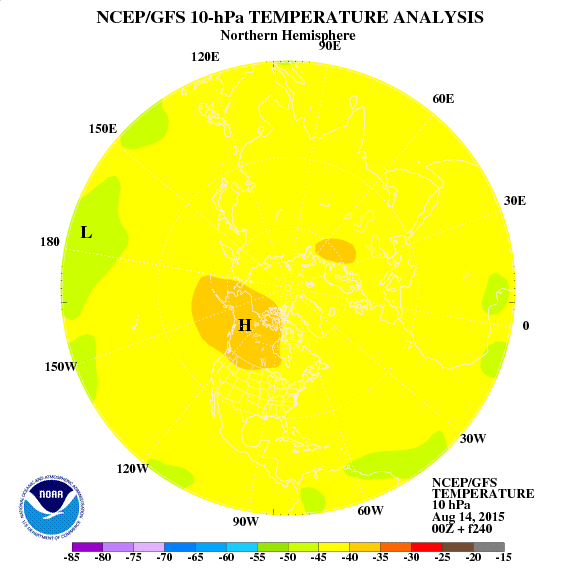
Hopefully a cold January...
Today
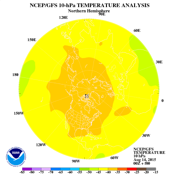
December 25th
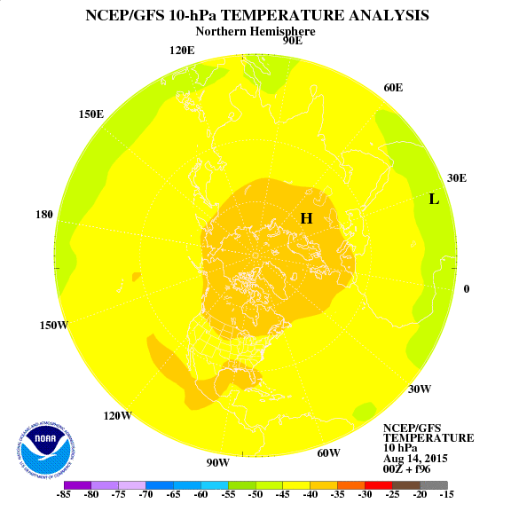
December 27th

New Years Eve
Today

December 25th

December 27th

New Years Eve

Team #NeverSummer
- srainhoutx
- Site Admin

- Posts: 19700
- Joined: Tue Feb 02, 2010 2:32 pm
- Location: Maggie Valley, NC
- Contact:
The 12Z GFS has come in a bit more enthusiastic regarding precip chances across Central/SE TX for Saturday (Christmas Eve). The upper trough is a touch slower and a coastal trough is a bit stronger suggesting over running conditions and a bit better lift along Coastal and Central Texas. That model has joined the over night Euro suggesting clouds will linger into Christmas Day as an upper air disturbance stalls across Old Mexico.
Carla/Alicia/Jerry(In The Eye)/Michelle/Charley/Ivan/Dennis/Katrina/Rita/Wilma/Humberto/Ike/Harvey
Member: National Weather Association
Facebook.com/Weather Infinity
Twitter @WeatherInfinity
Member: National Weather Association
Facebook.com/Weather Infinity
Twitter @WeatherInfinity