
Ok, I am brave enough. The May Climo....
NORMAL RECORD LOW RECORD HIGH RECORD CUMULATIVE PCPN
MAX MIN MAX YEAR MAX MIN YEAR MIN PCPN DAILY YEARLY
---------------------------------------------- -------------------------
1 81 63 94 1947 63 1907 45 1908 75 2002 4.11 1970 0.14 13.76
2 82 63 96 1964 65 1911 45 1976 76 2009* 3.48 1944 0.28 13.90
3 82 64 93 1890 60 1978 47 1978 77 2002 5.10 1981 0.42 14.04
4 82 64 94 1890 70 1966 44 1978 76 2003 1.72 1953 0.57 14.19
5 83 64 94 1906 66 1935 49 1970 76 2007* 3.60 1912 0.72 14.34
6 83 64 94 1906 63 1917 50 1970 76 2007 5.00 1938 0.87 14.49
7 84 65 94 1998 64 1917 47 1891 77 2002 2.61 1938 1.02 14.64
8 84 65 96 1967 69 1917 45 1906 78 2002 2.34 2005 1.17 14.79
9 84 65 94 1998 67 1924 46 1984 77 2002 2.42 1987 1.33 14.95
10 84 65 94 1927 69 1898 51 1984 76 2003 5.89 1968 1.49 15.11
11 85 65 94 1890 68 1898 47 1981 76 2010* 2.16 1959 1.65 15.27
12 85 66 92 1967 68 1917 50 1895 77 2002 5.27 1914 1.81 15.43
13 85 66 94 1907 70 1914 50 1895 78 1995 2.74 1966 1.97 15.59
14 85 66 93 1995 66 1953 47 1971 80 1995 2.44 2010 2.13 15.75
15 85 66 92 2003* 72 1934 49 1890 78 1995 4.64 1970 2.30 15.92
16 86 66 93 2003* 68 1945 47 1973 78 1974 2.80 1992 2.47 16.09
17 87 66 95 1894 68 1895 52 1970 79 1995 4.20 1989 2.64 16.26
18 87 66 95 1890 72 1916 50 1976 77 1981 6.16 1989 2.81 16.43
19 87 66 95 2003 71 1952 50 1976 77 1990 6.87 2000 2.98 16.60
20 87 66 95 2008 74 1958 48 1894 78 1990 4.17 1947 3.15 16.77
21 87 67 96 2005 71 1967 53 1892 77 1990 5.45 1945 3.32 16.94
22 87 67 96 2005* 65 1895 48 1892 77 2008 3.10 1963 3.50 17.12
23 87 67 95 1996 72 1947 45 1892 78 2008 3.99 1959 3.68 17.30
24 87 67 95 1955 74 1919 54 1892 78 1962 3.96 1936 3.86 17.48
25 87 68 95 1927 74 1936 56 1979 78 1980 2.47 1946 4.04 17.66
26 88 68 95 1958 76 1919 57 1979 79 1996 1.36 2007 4.22 17.84
27 88 68 98 1928 74 1901 50 1901 80 1996 3.99 1914 4.40 18.02
28 88 68 98 1906 73 1936 54 1901 81 1996 2.83 1914 4.58 18.20
29 88 68 99 1996 69 1992 58 1984 77 1953 4.33 2006 4.77 18.39
30 88 69 97 2003* 73 1947 53 1984 80 2004 5.01 1907 4.96 18.58
31 88 70 98 1998* 73 1992 50 1889 80 2004 3.45 1976 5.15 18.77
* indicates a record that has been tied on a previous year
May Normals
high: 85.5F
low: 66.1F
mean temperature: 75.8F
rainfall: 5.15"
heating DD 0
cooling DD 295
http://www.srh.noaa.gov/hgx/?n=climate_iah_normals_may
May Weather Discussions. Drougnt Continues For Houston
-
tireman4

- Global Moderator

- Posts: 7123
- Joined: Wed Feb 03, 2010 9:24 pm
- Location: Humble, Texas
- Contact:
-
unome
- Posts: 3062
- Joined: Fri Feb 12, 2010 6:11 pm

-
srainhoutx

- Site Admin

- Posts: 19700
- Joined: Tue Feb 02, 2010 2:32 pm
- Location: Maggie Valley, NC
- Contact:
Topics are merged. 12Z GFS suggest showers Saturday/Sunday Monday...unome wrote:sorry tireman, I posted one also - maybe they can delete mine or merge it with yours?
16 day TOTAL PRECIP: 1.19 " and Convective: 0.81 "
That would be more rain than we have seen at IAH since January. If only that model could finally be correct.
Carla/Alicia/Jerry(In The Eye)/Michelle/Charley/Ivan/Dennis/Katrina/Rita/Wilma/Humberto/Ike/Harvey
Member: National Weather Association
Facebook.com/Weather Infinity
Twitter @WeatherInfinity
Member: National Weather Association
Facebook.com/Weather Infinity
Twitter @WeatherInfinity
-
Ptarmigan

- Statistical Specialist

- Posts: 4519
- Joined: Wed Feb 03, 2010 7:20 pm
- Contact:
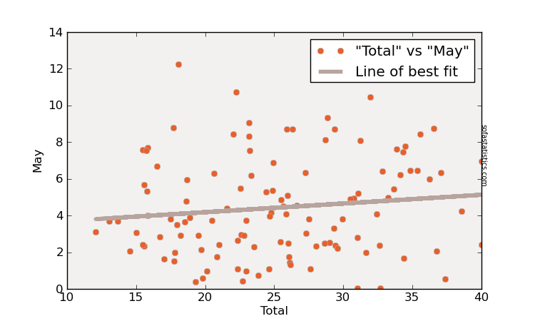
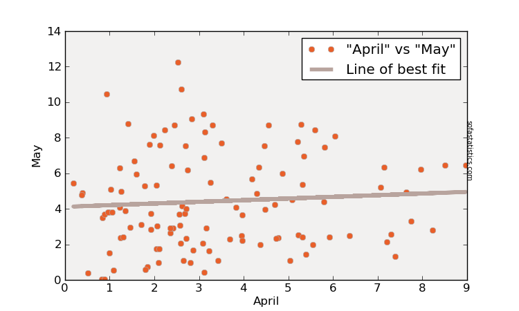
What does May holds? It could either be dry or wet.
Correlation between October to April and May Rainfall Total
Correlation between April and May Rainfall Total
Correlation between October to April and May Rainfall Total
Correlation between April and May Rainfall Total
-
wxman57

- Global Moderator
- Posts: 2621
- Joined: Thu Feb 04, 2010 5:34 am
- Location: Southwest Houston (Westbury)
- Contact:
We could very well see a shower/tstm late Sunday through Monday.
-
srainhoutx
- Site Admin
- Posts: 19700
- Joined: Tue Feb 02, 2010 2:32 pm
- Location: Maggie Valley, NC
- Contact:
Almost enough hope to get excited...but not yet...
LONG RANGE
MODELS ARE ALL ON THE SAME PAGE WITH A SLOW MOVING UPPER LEVEL
TROUGH AND SFC FRONT CROSSING THE AREA. THE UPPER FLOW LOOKS
PARALLEL TO THE FRONT SO THE FRONT WILL BE SLOW MOVING...MAYBE SO
SLOW MOVING THAT IT STALLS NORTH OF THE AREA. ALSO BOTH THE GFS
AND ECMWF HAVE A STRONG CAPPING INVERSION WHICH MAGICALLY VANISHES
AS THE FRONT ARRIVES. STILL QUITE A BIT OF UNCERTAINTY OF HOW
THINGS WILL EVOLVE. THAT SAID...MODEL CONSENSUS IS BUILDING FOR A
DECENT CHANCE OF RAIN WITH GOOD AREAL COVERAGE AND MODERATE
TOTALS.
Carla/Alicia/Jerry(In The Eye)/Michelle/Charley/Ivan/Dennis/Katrina/Rita/Wilma/Humberto/Ike/Harvey
Member: National Weather Association
Facebook.com/Weather Infinity
Twitter @WeatherInfinity
Member: National Weather Association
Facebook.com/Weather Infinity
Twitter @WeatherInfinity
-
srainhoutx
- Site Admin
- Posts: 19700
- Joined: Tue Feb 02, 2010 2:32 pm
- Location: Maggie Valley, NC
- Contact:
Sunday/Monday still look somewhat promising...hopefully...

Carla/Alicia/Jerry(In The Eye)/Michelle/Charley/Ivan/Dennis/Katrina/Rita/Wilma/Humberto/Ike/Harvey
Member: National Weather Association
Facebook.com/Weather Infinity
Twitter @WeatherInfinity
Member: National Weather Association
Facebook.com/Weather Infinity
Twitter @WeatherInfinity
-
srainhoutx
- Site Admin
- Posts: 19700
- Joined: Tue Feb 02, 2010 2:32 pm
- Location: Maggie Valley, NC
- Contact:
Long range (hour 84) 12Z WRF suggests we will see rain on Sunday/Monday...
Carla/Alicia/Jerry(In The Eye)/Michelle/Charley/Ivan/Dennis/Katrina/Rita/Wilma/Humberto/Ike/Harvey
Member: National Weather Association
Facebook.com/Weather Infinity
Twitter @WeatherInfinity
Member: National Weather Association
Facebook.com/Weather Infinity
Twitter @WeatherInfinity
-
srainhoutx
- Site Admin
- Posts: 19700
- Joined: Tue Feb 02, 2010 2:32 pm
- Location: Maggie Valley, NC
- Contact:
Fingers crossed...SPC:
DAY 3 CONVECTIVE OUTLOOK
NWS STORM PREDICTION CENTER NORMAN OK
0147 AM CDT FRI APR 29 2011
VALID 011200Z - 021200Z
...SYNOPSIS...
A LARGE POSITIVELY TILTED UPPER TROUGH WILL AFFECT MUCH OF THE CNTRL
U.S. ON SUNDAY WITH A BROAD BELT OF 50-70 KT MID LEVEL FLOW. AT THE
SURFACE...A COLD FRONT IS FORECAST TO CONTINUE RAPIDLY SWD ACROSS
TX...WITH VERY COOL AIR BEHIND. AHEAD OF THE FRONT...A MOIST AND
UNSTABLE AIR MASS WILL EXIST WITH UPPER 60S F DEWPOINTS AND HEATING.
...MUCH OF CNTRL AND ERN TX INTO SRN AR...LA...MS...
SCATTERED STORMS ARE LIKELY TO BE ONGOING ALONG THE AND N OF THE
COLD FRONT SUNDAY MORNING...AND WILL GRADUALLY INCREASE IN INTENSITY
THROUGHOUT THE DAY AS HEATING DESTABILIZES THE WARM SECTOR. DEEP
LAYER FLOW WILL BE MOSTLY PARALLEL TO THE FRONT...AND GIVEN THE FAST
COLD FRONT MOTION SWD...STORMS MAY GET UNDERCUT BY COOL/STABLE
AIR...CAUSING THEM TO BECOME ELEVATED. A MAINLY DAMAGING WIND THREAT
MAY EXIST WITH THE STRONGER CELLS BEFORE THIS OCCURS...AND SOME HAIL
MAY OCCUR AS WELL ESPECIALLY DURING THE DAYTIME.
..JEWELL.. 04/29/2011
- Attachments
-
Carla/Alicia/Jerry(In The Eye)/Michelle/Charley/Ivan/Dennis/Katrina/Rita/Wilma/Humberto/Ike/Harvey
Member: National Weather Association
Facebook.com/Weather Infinity
Twitter @WeatherInfinity
Member: National Weather Association
Facebook.com/Weather Infinity
Twitter @WeatherInfinity
-
wxman57
- Global Moderator
- Posts: 2621
- Joined: Thu Feb 04, 2010 5:34 am
- Location: Southwest Houston (Westbury)
- Contact:
I'd agree, 0.25" or less next Mon/Tue. Not looking good, but a better chance than last Sunday.Ed Mahmoud wrote:wxman57 wrote:We could very well see a shower/tstm late Sunday through Monday.
The GFS has been money the past month or so of dry weather, the Euro has been dismal more than a couple days out, so, based entirely on rather weak empirical data, I say a quarter inch or less, total, averaged IAH, DWH and HOU, the next seven days. I won't let one heavier shower dropping 3 tenths in a single official site ruin this, hence the 3 station average.
-
srainhoutx
- Site Admin
- Posts: 19700
- Joined: Tue Feb 02, 2010 2:32 pm
- Location: Maggie Valley, NC
- Contact:
I'm actually a bit more encouraged today regarding rain chance. While this will not be a gully washer by any stretch of the imagination, then trend has been to slow down the frontal boundary across TX at least allowing for drought/fire areas to have a multi day shot at rainfall.
Carla/Alicia/Jerry(In The Eye)/Michelle/Charley/Ivan/Dennis/Katrina/Rita/Wilma/Humberto/Ike/Harvey
Member: National Weather Association
Facebook.com/Weather Infinity
Twitter @WeatherInfinity
Member: National Weather Association
Facebook.com/Weather Infinity
Twitter @WeatherInfinity
-
jasons2k

- Posts: 6192
- Joined: Thu Feb 04, 2010 12:54 pm
- Location: Imperial Oaks
- Contact:
I sure hope we see more than .25"! That's paltry!
I think you're all just gun-shy with the drought. There - I said it - now I've really jinxed it!
I think you're all just gun-shy with the drought. There - I said it - now I've really jinxed it!
-
jasons2k
- Posts: 6192
- Joined: Thu Feb 04, 2010 12:54 pm
- Location: Imperial Oaks
- Contact:
For about 10 minutes I was hoping that cell near Austin would hold together and/or grow into something that would clip us....and after those 10 minutes the radar quickly brought me back down to reality....Ed Mahmoud wrote:Boy was I hoping against hope last weekend and Monday that storm coverage would increase enough for a cold pool to drive something down this way. It almost did...
-
srainhoutx
- Site Admin
- Posts: 19700
- Joined: Tue Feb 02, 2010 2:32 pm
- Location: Maggie Valley, NC
- Contact:
From NWS Austin/San Antonio: 
MOSTLY CLOUDY AND MUCH COOLER SUNDAY NIGHT AS
IMPULSES ALOFT SWEEP NORTHEAST AND COMBINED WITH ISENTROPIC
LIFT OF GULF MOISTURE BEHIND THE FRONTAL SURFACE...WE`LL HAVE
THE BEST CHANCES OF SIGNIFICANT RAIN SEEN HERE IN A LONG TIME.
MOSTLY CLOUDY AND MUCH COOLER SUNDAY NIGHT AS
IMPULSES ALOFT SWEEP NORTHEAST AND COMBINED WITH ISENTROPIC
LIFT OF GULF MOISTURE BEHIND THE FRONTAL SURFACE...WE`LL HAVE
THE BEST CHANCES OF SIGNIFICANT RAIN SEEN HERE IN A LONG TIME.
Carla/Alicia/Jerry(In The Eye)/Michelle/Charley/Ivan/Dennis/Katrina/Rita/Wilma/Humberto/Ike/Harvey
Member: National Weather Association
Facebook.com/Weather Infinity
Twitter @WeatherInfinity
Member: National Weather Association
Facebook.com/Weather Infinity
Twitter @WeatherInfinity
-
srainhoutx
- Site Admin
- Posts: 19700
- Joined: Tue Feb 02, 2010 2:32 pm
- Location: Maggie Valley, NC
- Contact:
HGX HWO (Hazardous Weather Outlook):
.DAYS TWO THROUGH SEVEN...SATURDAY THROUGH THURSDAY
IT WILL BE BREEZY ON SATURDAY. A SLOW MOVING COLD FRONT WILL GRADUALLY
MOVE INTO AND THROUGH THE AREA SUNDAY AFTERNOON THROUGH TUESDAY MORNING.
THIS BOUNDARY COULD ACT AS A FOCUS FOR SHOWER AND THUNDERSTORM DEVELOPMENT
THROUGH THE PERIOD. SOME OF THE STORMS COULD HAVE THE POTENTIAL TO BECOME
STRONG OR SEVERE SUNDAY AFTERNOON THROUGH SUNDAY EVENING.
Carla/Alicia/Jerry(In The Eye)/Michelle/Charley/Ivan/Dennis/Katrina/Rita/Wilma/Humberto/Ike/Harvey
Member: National Weather Association
Facebook.com/Weather Infinity
Twitter @WeatherInfinity
Member: National Weather Association
Facebook.com/Weather Infinity
Twitter @WeatherInfinity
-
Ptarmigan
- Statistical Specialist
- Posts: 4519
- Joined: Wed Feb 03, 2010 7:20 pm
- Contact:
Let's hope for rain and rid the cockroach cap once and for all.srainhoutx wrote:HGX HWO (Hazardous Weather Outlook):
.DAYS TWO THROUGH SEVEN...SATURDAY THROUGH THURSDAY
IT WILL BE BREEZY ON SATURDAY. A SLOW MOVING COLD FRONT WILL GRADUALLY
MOVE INTO AND THROUGH THE AREA SUNDAY AFTERNOON THROUGH TUESDAY MORNING.
THIS BOUNDARY COULD ACT AS A FOCUS FOR SHOWER AND THUNDERSTORM DEVELOPMENT
THROUGH THE PERIOD. SOME OF THE STORMS COULD HAVE THE POTENTIAL TO BECOME
STRONG OR SEVERE SUNDAY AFTERNOON THROUGH SUNDAY EVENING.
-
sleetstorm
- Posts: 651
- Joined: Thu Feb 04, 2010 12:33 pm
- Contact:
Does it look like this feasible rain maker will also be a major severe thunderstorm outbreak for southeast Texas or no?
-
wxman57
- Global Moderator
- Posts: 2621
- Joined: Thu Feb 04, 2010 5:34 am
- Location: Southwest Houston (Westbury)
- Contact:
Latest GFS run only forecasts a few tenths of an inch of rain here Mon/Tue, but some fairly cool air for mid week. Severe weather chances here are quite minimal. Could see a thunderstorm, maybe. Here's a meteogram I made. Had to adjust the right (rainfall) axis to a max of only 0.25" in 3 hrs to get the green bars at the bottom to register a little better.

-
srainhoutx
- Site Admin
- Posts: 19700
- Joined: Tue Feb 02, 2010 2:32 pm
- Location: Maggie Valley, NC
- Contact:
The 12Z NAM has trended a bit wetter for areas N and W of downtown. There are also hints of an Upper Air disturbance riding up the coast along the very slow moving frontal boundary.
- Attachments
-
Carla/Alicia/Jerry(In The Eye)/Michelle/Charley/Ivan/Dennis/Katrina/Rita/Wilma/Humberto/Ike/Harvey
Member: National Weather Association
Facebook.com/Weather Infinity
Twitter @WeatherInfinity
Member: National Weather Association
Facebook.com/Weather Infinity
Twitter @WeatherInfinity