January Weather Discussion: Slight Chance Severe Storms

General Weather Discussions and Analysis
Post Reply
User avatar
srainhoutx
Site Admin
Site Admin
Posts: 19685
Joined: Tue Feb 02, 2010 2:32 pm
Location: Maggie Valley, NC
Contact:

Time to watch the march S of that 'cold dreary' air mass beginning to spill across the border...

Image

Image

Image
Carla/Alicia/Jerry(In The Eye)/Michelle/Charley/Ivan/Dennis/Katrina/Rita/Wilma/Humberto/Ike/Harvey

Member: National Weather Association
Facebook.com/Weather Infinity
Twitter @WeatherInfinity
biggerbyte
Posts: 1396
Joined: Thu Feb 04, 2010 12:15 am
Location: Porter, Texas. (Montgomery County)
Contact:

[quote="srainhoutx"]Time to watch the march S of that 'cold dreary' air mass beginning to spill across the border...


Lol

I like your style...
User avatar
srainhoutx
Site Admin
Site Admin
Posts: 19685
Joined: Tue Feb 02, 2010 2:32 pm
Location: Maggie Valley, NC
Contact:

Our Wednesday/Thursday 'event' is nearing the Pacific NW tonight. Hopefully better sampling and data from those Winter RECON missions will assist guidance via the 00Z's...

Image

000
NOUS42 KNHC 171700
WEATHER RECONNAISSANCE FLIGHTS
CARCAH, NATIONAL HURRICANE CENTER, MIAMI, FL.
1200 PM EST MON 17 JANUARY 2011
SUBJECT: WINTER STORM PLAN OF THE DAY (WSPOD)
VALID 18/1100Z TO 19/1100Z JANUARY 2011
WSPOD NUMBER.....10-048

I. ATLANTIC REQUIREMENTS
1. NEGATIVE RECONNAISSANCE REQUIREMENTS.
2. OUTLOOK FOR SUCCEEDING DAY.....NEGATIVE.
3. REMARK: WC-130 WINTER STORM MISSIONS TASKED
ON WSPOD 10-047 WILL FLY AS SCHEDULED.

II. PACIFIC REQUIREMENTS
1. NEGATIVE RECONNAISSANCE REQUIREMENTS.
2. SUCCEEDING DAY OUTLOOK:
A. P68/20/1200Z/(DROP 11)50.3N 168.0E
JWP
Carla/Alicia/Jerry(In The Eye)/Michelle/Charley/Ivan/Dennis/Katrina/Rita/Wilma/Humberto/Ike/Harvey

Member: National Weather Association
Facebook.com/Weather Infinity
Twitter @WeatherInfinity
User avatar
srainhoutx
Site Admin
Site Admin
Posts: 19685
Joined: Tue Feb 02, 2010 2:32 pm
Location: Maggie Valley, NC
Contact:

The 00Z's have started. The NAM suggests a trough building across the Great Basin and Rockies. I noticed that International Falls, MN is the 'coldest' and NE is a close second through 48 hours via the NAM. Maybe the night crew will have some thoughts... :mrgreen:
Carla/Alicia/Jerry(In The Eye)/Michelle/Charley/Ivan/Dennis/Katrina/Rita/Wilma/Humberto/Ike/Harvey

Member: National Weather Association
Facebook.com/Weather Infinity
Twitter @WeatherInfinity
Andrew
Site Admin
Site Admin
Posts: 3497
Joined: Wed Feb 03, 2010 9:46 pm
Location: North-West Houston
Contact:

Nam is colder so far through 72h
For Your Infinite Source For All Things Weather Visit Our Facebook
Andrew
Site Admin
Site Admin
Posts: 3497
Joined: Wed Feb 03, 2010 9:46 pm
Location: North-West Houston
Contact:

Wow Nam is a lot colder


The trough on this run came in a lot stronger with the contour lines very north to south oriented.
For Your Infinite Source For All Things Weather Visit Our Facebook
sleetstorm
Posts: 651
Joined: Thu Feb 04, 2010 12:33 pm
Contact:

Andrew wrote:Wow Nam is a lot colder


The trough on this run came in a lot stronger with the contour lines very north to south oriented.
What time frame is that model showing, Andrew, and where is the wave of low pressure that was in southern Texas?
Andrew
Site Admin
Site Admin
Posts: 3497
Joined: Wed Feb 03, 2010 9:46 pm
Location: North-West Houston
Contact:

sleetstorm wrote:
Andrew wrote:Wow Nam is a lot colder


The trough on this run came in a lot stronger with the contour lines very north to south oriented.
What time frame is that model showing, Andrew, and where is the wave of low pressure that was in southern Texas?

84-90 hours away. Um as for the coastal low I don't think the NAM has been showing that but I will check that out.
For Your Infinite Source For All Things Weather Visit Our Facebook
Andrew
Site Admin
Site Admin
Posts: 3497
Joined: Wed Feb 03, 2010 9:46 pm
Location: North-West Houston
Contact:

Nothing special for GFS
For Your Infinite Source For All Things Weather Visit Our Facebook
User avatar
wxman57
Global Moderator
Global Moderator
Posts: 2621
Joined: Thu Feb 04, 2010 5:34 am
Location: Southwest Houston (Westbury)
Contact:

If the Arctic air doesn't sink south across Texas tomorrow, well in advance of the upper-level trof then chances of any significant ice event from Dallas southward are quite low. And I'm just not seeing the signs of a significant southward push of Arctic air today. That means the near-freezing or sub-freezing air arrives just about as (or after) the precip ends across Texas on Thursday. Still a fair shot at winter precip from the Red River area northward across OK, but it doesn't look like a long-lasting event. Sleet/snow for Oklahoma and Kansas and eastward, just more cold air for us.

Canadian has backed off on any extreme cold, and what I'm seeing in the Northern Plains isn't really that cold today. We'll see a couple of light freezes and then a slow warm up, most likely.
ticka1
Posts: 1265
Joined: Wed Feb 03, 2010 3:02 pm
Location: Baytown/Mont Belvieu
Contact:

Tuesday morning email from Jeff Lindner:

Widespread fog and low clouds blanket the area this morning as low levels remain saturated. Visibilities range from ¼ of a mile at Conroe to 1 mile at Palacios. Not sure how long it will take today to break through the low deck and fog. It took much of yesterday to finally break out and with less mixing today, some areas especially N of I-10 and E of I-45 may never break through. Temperatures will be strongly dependant on where/if clearing develops. Areas that break into the sun will easily warm into the mid –upper 60’s while other areas under the clouds/fog will struggle to reach 60.


A weak cold front will cross the area this afternoon ushering in a cooler and drier air mass. This front should help rid the area of the fog and drizzle, but it may take until this evening to scattered out the low level stratus. Clear and cold tonight with lows in the upper 30’s and lower 40’s under weak NW winds.


Mainly sunny and mild conditions expected Wednesday and early Thursday with lows in the 40’s and highs in the 60’s.


Clouds will increase Thursday as a strong polar (modified arctic) front sweeps across the region. Expect the front to reach our NW counties by early afternoon and sweep off the coast by mid evening. Temperatures will rapidly fall on strong NW winds into the 30’s and 40’s behind the boundary. There will be a chance of rain with the front, but chances appear weaker than previous wet systems of late and only looking at 20-30% at this time.


Polar high will be in place across the region Friday with cold temperatures under clearing skies. Expect highs only in the upper 40’s to lower 50’s across the region. Freezing temperatures are likely Saturday morning with lows in the upper 20’s and low 30’s. Winds swing back around to the south late Saturday/early Sunday ahead of the next front currently due in late Sunday.
ticka1
Posts: 1265
Joined: Wed Feb 03, 2010 3:02 pm
Location: Baytown/Mont Belvieu
Contact:

wxman57 wrote:If the Arctic air doesn't sink south across Texas tomorrow, well in advance of the upper-level trof then chances of any significant ice event from Dallas southward are quite low. And I'm just not seeing the signs of a significant southward push of Arctic air today. That means the near-freezing or sub-freezing air arrives just about as (or after) the precip ends across Texas on Thursday. Still a fair shot at winter precip from the Red River area northward across OK, but it doesn't look like a long-lasting event. Sleet/snow for Oklahoma and Kansas and eastward, just more cold air for us.

Canadian has backed off on any extreme cold, and what I'm seeing in the Northern Plains isn't really that cold today. We'll see a couple of light freezes and then a slow warm up, most likely.
Will we see any rain from this system? My yard is a swamp - would like it to dry out a little before another round of rain!
User avatar
wxman57
Global Moderator
Global Moderator
Posts: 2621
Joined: Thu Feb 04, 2010 5:34 am
Location: Southwest Houston (Westbury)
Contact:

Not much rain, ticka. The air in place across southeast Texas ahead of the front on Thursday won't have much moisture in it.
User avatar
srainhoutx
Site Admin
Site Admin
Posts: 19685
Joined: Tue Feb 02, 2010 2:32 pm
Location: Maggie Valley, NC
Contact:

wxman57 wrote:Not much rain, ticka. The air in place across southeast Texas ahead of the front on Thursday won't have much moisture in it.
Certainly nothing like last Saturday evening/Sunday...

GFS Ensemble
01182011 00Z GFE Ensemble Precip Temp 00zgfsensemblep12060.gif
01182011 00Z GFS Ensemble Precip Temp 00zgfsensemblep12072.gif
GGEM (Canadian) Ensemble
01182011 00Z GGEM Precip Temp 00zggemensemblep12060.gif
01182011 00Z GGEM Precip Temp 00zggemensemblep12072.gif
Carla/Alicia/Jerry(In The Eye)/Michelle/Charley/Ivan/Dennis/Katrina/Rita/Wilma/Humberto/Ike/Harvey

Member: National Weather Association
Facebook.com/Weather Infinity
Twitter @WeatherInfinity
redneckweather
Posts: 1058
Joined: Mon Feb 08, 2010 7:29 pm
Location: Montgomery, Texas
Contact:

Typical January weak modified arctic front. So far I have been right about my prediction of us seeing our coldest temperatures of the fall/winter season which was last year. I got down to 24 last week but got down to 22 last November at my house. We have officially seen our coldest air of the season IMO.

Disclaimer: This is not a forecast!!! Strictly my opinion...which will play out. :D
User avatar
srainhoutx
Site Admin
Site Admin
Posts: 19685
Joined: Tue Feb 02, 2010 2:32 pm
Location: Maggie Valley, NC
Contact:

FYI: NCEP site has failed nationwide.
Carla/Alicia/Jerry(In The Eye)/Michelle/Charley/Ivan/Dennis/Katrina/Rita/Wilma/Humberto/Ike/Harvey

Member: National Weather Association
Facebook.com/Weather Infinity
Twitter @WeatherInfinity
User avatar
wxman57
Global Moderator
Global Moderator
Posts: 2621
Joined: Thu Feb 04, 2010 5:34 am
Location: Southwest Houston (Westbury)
Contact:

srainhoutx wrote:FYI: NCEP site has failed nationwide.
I noticed that. Seems to come up occasionally, though.
User avatar
srainhoutx
Site Admin
Site Admin
Posts: 19685
Joined: Tue Feb 02, 2010 2:32 pm
Location: Maggie Valley, NC
Contact:

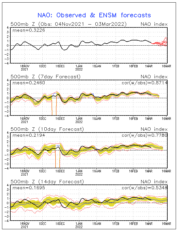
After our cool down on Thursday, all the guidance is beginning to suggest that the Sunday/Monday time frame may well be another heavy rain event as a much stronger Upper Air disturbance head SE from the Pacific NW into the Great Basin/Intermountain W. Some wintry weather may materialize to our N. We will see. We are in a very progressive pattern with an active NW flow and suggestions of Upper Air features to our W and SW with fronts expected every few days as we head to the end of January.

With that said, we do have some things working in our favor regarding the pattern ahead, for those looking for a cooler/stormier pattern across the Eastern 2/3 of The CONUS... ;)

Image

Image

Image
Carla/Alicia/Jerry(In The Eye)/Michelle/Charley/Ivan/Dennis/Katrina/Rita/Wilma/Humberto/Ike/Harvey

Member: National Weather Association
Facebook.com/Weather Infinity
Twitter @WeatherInfinity
User avatar
Ptarmigan
Statistical Specialist
Posts: 4270
Joined: Wed Feb 03, 2010 7:20 pm
Contact:

Two different La Nina forecasts.

Image

Image

One has a prologed La Nina that lasts for more than a year. The last time that happened was Fall 1998 to Spring 2001. The other forecast has it over by the summer.
User avatar
srainhoutx
Site Admin
Site Admin
Posts: 19685
Joined: Tue Feb 02, 2010 2:32 pm
Location: Maggie Valley, NC
Contact:

Interesting discussion from the CPC regarding the sensible weather expected until the first of February...

PROGNOSTIC DISCUSSION FOR 6 TO 10 AND 8 TO 14 DAY OUTLOOKS
NWS CLIMATE PREDICTION CENTER CAMP SPRINGS, MD
300 PM EST TUE JANUARY 18 2011

6-10 DAY OUTLOOK FOR JAN 24 - 28 2011

TODAYS MODEL SOLUTIONS ARE IN FAIRLY GOOD AGREEMENT ON THE 500-HPA HEIGHT
PATTERN OVER THE FORECAST DOMAIN. ALL MODELS PREDICT TROUGHS OVER EASTERN
NORTH AMERICA AND OVER THE BERING SEA WITH RIDGING NEAR THE WEST COAST OF THE CONUS.
MOST MODELS ALSO PREDICT A MEAN POSITIVELY TILTED LONGWAVE TROUGH
EXTENDING TOWARD THE SOUTHWESTERN CONUS, HOWEVER THERE ARE LARGE DISAGREEMENTS
AS TO THE DETAILS OF THIS FEATURE. TODAY'S OFFICIAL 500-HPA HEIGHT BLEND
REPRESENTS A FAIRLY EVEN SPLIT BETWEEN THE GFS, CANADIAN, AND ECMWF BASED
SOLUTIONS.

ABOVE NORMAL TEMPERATURES ARE FAVORED FOR MUCH OF THE NORTHWEST CONUS AND
ALASKA PANHANDLE IN ASSOCIATION WITH THE RIDGE FORECAST NEAR THE WEST COAST OF
NORTH AMERICA. DOWNSTREAM OF THIS RIDGE, THE TROUGH FORECAST OVER EASTERN
NORTH AMERICA FAVORS BELOW NORMAL TEMPERATURES FOR MOST OF THE EASTERN HALF OF
THE NATION.
BELOW NORMAL TEMPERATURES ARE ALSO FAVORED FOR PARTS OF WESTERN
ALASKA NEAR THE TROUGH FORECAST OVER THE BERING SEA.

MOIST FLOW AHEAD OF THE TROUGH FORECAST OVER THE BERING SEA FAVORS ABOVE MEDIAN
PRECIPITATION FOR THE SOUTH COAST AND PANHANDLE OF ALASKA. ABOVE MEDIAN
PRECIPITATION IS ALSO FAVORED FOR MUCH OF THE GULF OF MEXICO COAST REGION AND
SOUTHEAST AS SOME MODELS FORECAST SHORTWAVE ENERGY TO TRAVERSE THE SOUTHERN
TIER OF THE CONUS AROUND THE BASE OF THE MEAN LONGWAVE TROUGH OVER EASTERN
NORTH AMERICA. ENHANCED PROBABILITIES OF NEAR OR ABOVE MEDIAN PRECIPITATION
ARE ALSO INDICATED ALONG THE EASTERN SEABOARD AHEAD OF THE MEAN TROUGH AXIS.
SUBSIDENCE BEHIND THIS LONGWAVE TROUGH LEADS TO ENHANCED PROBABILITIES OF BELOW
OR NEAR MEDIAN PRECIPITATION FOR THE GREAT LAKES REGION. NEAR TO BELOW MEDIAN
PRECIPITATION IS ALSO FAVORED FOR MUCH OF THE WESTERN CONUS DUE TO THE RIDGE
FORECAST NEAR THE WEST COAST OF NORTH AMERICA.

TODAY'S OFFICIAL 500-HPA BLEND CONSISTS OF 5 PERCENT OF TODAY'S OPERATIONAL 0Z
GFS CENTERED ON DAY 8...10 PERCENT OF TODAY'S OPERATIONAL 6Z GFS CENTERED ON
DAY 8...15 PERCENT OF TODAY'S 0Z GFS ENSEMBLE MEAN CENTERED ON DAY 8...15
PERCENT OF TODAY'S 6Z GFS ENSEMBLE MEAN CENTERED ON DAY 8...15 PERCENT OF
TODAY'S 0Z EUROPEAN ENSEMBLE MEAN CENTERED ON DAY 8...15 PERCENT OF TODAY'S 0Z
CANADIAN ENSEMBLE MEAN CENTERED ON DAY 8...5 PERCENT OF YESTERDAY'S 12Z
EUROPEAN ENSEMBLE MEAN CENTERED ON DAY 7...AND 20 PERCENT OF YESTERDAY'S 12Z
CANADIAN ENSEMBLE MEAN CENTERED ON DAY 7.

MODEL OF THE DAY: YESTERDAYS 12Z CANADIAN ENSEMBLE MEAN

FORECAST CONFIDENCE FOR THE 6-10 DAY PERIOD: AVERAGE, 3 ON A SCALE OF 1 TO 5
DUE TO GOOD MODEL AGREEMENT OFFSET BY HIGH UNCERTAINTY IN THE PRECIPITATION
FORECAST ALONG THE EAST COAST.

8-14 DAY OUTLOOK FOR JAN 26 - FEB 01, 2011

MODEL SOLUTIONS FOR THE MEAN 500-HPA HEIGHTS EXPECTED FOR THE 8 TO 14 DAY
PERIOD GENERALLY PREDICT A SLIGHT PROGRESSION OF THE MAIN FEATURES OVER THE
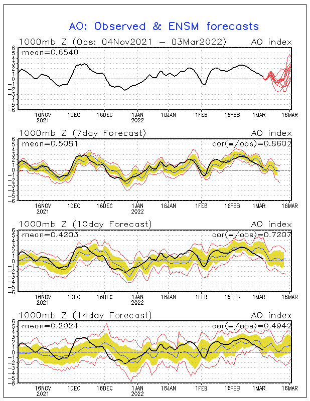
CONUS FROM THAT FORECAST FOR THE 6 TO 10 DAY PERIOD. THE NEGATIVE AO THAT HAS
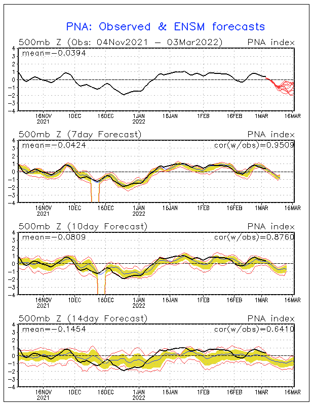
BEEN PRESENT FOR MUCH OF THE WINTER IS FORECAST TO WEAKEN WHILE THE PNA IS
EXPECTED TO BE POSITIVE THROUGHOUT THE PERIOD. LONGWAVE TROUGHS ARE FORECAST
FOR EASTERN NORTH AMERICA AND WESTERN ALASKA WITH A RIDGE FORECAST OVER THE
NORTHWESTERN CONUS.

IN GENERAL, THE FORECAST TEMPERATURE AND PRECIPITATION PROBABILITY PATTERNS ARE
CONSISTENT WITH A POSITIVE PNA. THE FORECAST RIDGE OVER WESTERN NORTH AMERICA
FAVORS ENHANCED PROBABILITIES OF ABOVE NORMAL TEMPERATURES FOR THE NORTHWESTERN
CONUS AND EASTERN ALASKA. ENHANCED PROBABILITIES OF BELOW NORMAL TEMPERATURES
CONTINUE TO BE INDICATED FOR MUCH OF THE EASTERN AND SOUTHERN CONUS IN
ASSOCIATION WITH THE MEAN LONGWAVE TROUGH FORECAST IN THE VICINITY
.


BELOW MEDIAN PRECIPITATION IS FAVORED FOR MUCH OF THE OHIO AND TENNESSEE
VALLEYS DUE TO SUBSIDENCE BEHIND THE EASTERN NORTH AMERICA TROUGH. SHORTWAVE
ENERGY ROTATING AROUND THE BASE OF THIS TROUGH FAVORS ABOVE MEDIAN
PRECIPITATION FOR PARTS OF SOUTHERN TEXAS AND THE FLORIDA PENINSULA.
OVER THE
WEST, THE FORECAST LONGWAVE RIDGE FAVORS NEAR TO BELOW MEDIAN PRECIPITATION
WHILE MOIST FLOW AHEAD OF THE UPSTREAM TROUGH OVER THE BERING SEA FAVORS ABOVE
MEDIAN PRECIPITATION FOR THE ALASKAN SOUTH COAST AND PANHANDLE.

THE OFFICIAL 8-14 DAY HEIGHT PROG CONSISTS OF: 10 PERCENT OF TODAY'S
OPERATIONAL 0Z GFS CENTERED ON DAY 11...20 PERCENT OF TODAY'S 0Z GFS ENSEMBLE
MEAN CENTERED ON DAY 11...20 PERCENT OF TODAY'S 6Z GFS ENSEMBLE MEAN CENTERED
ON DAY 11...15 PERCENT OF TODAY'S 0Z EUROPEAN ENSEMBLE MEAN CENTERED ON DAY
11...20 PERCENT OF YESTERDAY'S 12Z EUROPEAN ENSEMBLE MEAN CENTERED ON DAY
10...AND 15 PERCENT OF YESTERDAY'S 12Z CANADIAN ENSEMBLE MEAN CENTERED ON DAY
10.

FORECAST CONFIDENCE FOR THE 8-14 DAY PERIOD IS: AVERAGE, 3 ON A SCALE OF 1 TO 5.


FORECASTER: SCOTT HANDEL
Carla/Alicia/Jerry(In The Eye)/Michelle/Charley/Ivan/Dennis/Katrina/Rita/Wilma/Humberto/Ike/Harvey

Member: National Weather Association
Facebook.com/Weather Infinity
Twitter @WeatherInfinity
Post Reply
  • Information
  • Who is online

    Users browsing this forum: Ahrefs [Bot] and 6 guests