
This is a 384 hour forecast from
http://ready.arl.noaa.gov/READYcmet.php
GFSlr#
Latitude: 29.75 Longitude: -95.35 &
DATA INITIAL TIME: 02 JAN 2011 12Z&03{
CALCULATION STARTED AT: 10 JAN 2011 12Z&
HOURS OF CALCULATION: 192 &
FIELD TEMPERATURE DEW POINT TEMPERATURE TEMPERATURE PRECIPITATION
LEVEL 2M 2M 850 MB 500 MB
UNITS DEGC DEGC DEGC DEGC MM
HR
+ 0. 0.5 -3.6 1.0 -17.0 0.00
+ 12. 4.6 -3.0 1.2 -14.4 0.00
+ 24. 1.4 -4.0 2.3 -10.9 0.00
+ 36. 7.6 1.3 3.4 -10.9 0.01
+ 48. 6.1 5.0 4.9 -11.2 0.00
+ 60. 13.7 11.5 7.3 -11.7 0.14
+ 72. 14.9 14.1 8.0 -13.9 0.12
+ 84. 17.5 16.3 10.1 -12.5 0.88
+ 96. 14.3 13.6 9.2 -12.9 2.00
+108. 4.5 2.7 9.6 -15.4 3.17
+120. 2.5 1.2 8.2 -14.5 1.25
+132. 5.8 3.9 9.6 -12.4 0.61
+144. 4.8 3.8 10.3 -13.8 2.00
+156. 3.6 2.5 8.0 -12.1 2.58
+168. -1.0 -2.1 5.7 -10.3 0.09
+180. 4.8 1.6 7.3 -10.9 0.09
+192. 4.6 3.1 8.9 -13.1 0.26
The bolded one caught my attention.
January Weather Discussion: Slight Chance Severe Storms
-
Ptarmigan

- Statistical Specialist

- Posts: 4513
- Joined: Wed Feb 03, 2010 7:20 pm
- Contact:
-
Ptarmigan
- Statistical Specialist
- Posts: 4513
- Joined: Wed Feb 03, 2010 7:20 pm
- Contact:
Talk about cold right there! BRRRRRRRRRRR!!!!!!!!!!!!!!!Baseballdude2915 wrote:Wx Underground has backed off, now it will be a balmy -85F Wednesday Night in Ojmjakon. WOW.
Looking at the Wiki page for that town, they stay below 0 from late October to late March.
-
Ptarmigan
- Statistical Specialist
- Posts: 4513
- Joined: Wed Feb 03, 2010 7:20 pm
- Contact:
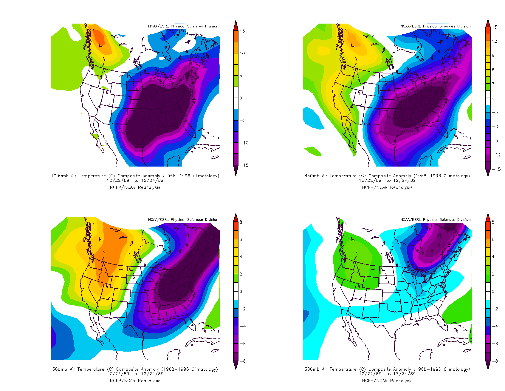
I don't think this freeze will be as potent as 1989. The pressure is not as high.txsnowmaker wrote:Srain, is this run depicting a December 1989-type setup temperature wise (or something even colder)?srainhoutx wrote:The Euro suggests an amazing bitter cold airmass settling in with reinforcing shots to follow. Wow!
December 1989 freeze was a potent freeze, in some ways more potent than December 1983. 1989 was cold at all levels, unlike 1989.
December 1983
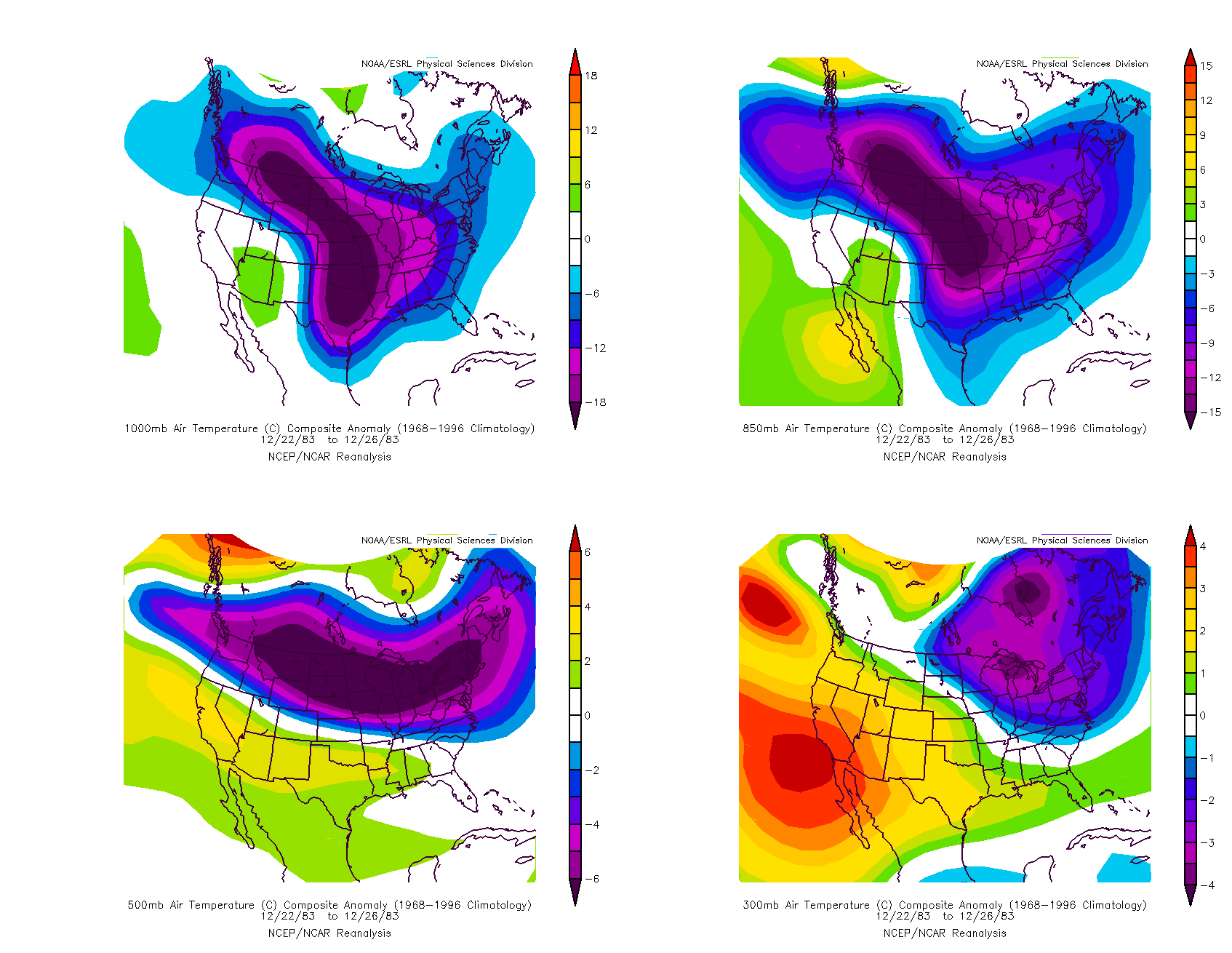
December 1989
-
Ptarmigan
- Statistical Specialist
- Posts: 4513
- Joined: Wed Feb 03, 2010 7:20 pm
- Contact:
We should certainly pay attention to the cold weather in Eurasia, mainly Siberia. The cold air in Eurasia makes it down to CONUS via Siberia, Alaska, and Canada. That is how many of the big freezes happen. I would imagine the February 1899 freeze had a similar setup to December 1983 and 1989, except it affected the whole nation! That is unheard of.txsnowmaker wrote:
A bit too soon to know with any certainty, but with the record cold building in Eurasia, it is certainly not out of the realm of possibilities. We will need to watch this very closely in the days ahead. The consistency via virtually all guidance lends credence to such an outbreak.
Thank you very much for the prompt response (and yours as well Candy Cane) and keeping everyone informed. Will certainly be keeping an eye on this one. Happy New Year to all.
-
sambucol

- Posts: 1244
- Joined: Wed Feb 03, 2010 5:43 pm
- Location: Mont Belvieu
- Contact:
It's looking like it really is going to be get cold here with these runs being consistent. Are we looking at probable pipe-busting temps maybe similar January 2010? There are extra precautions we take around the house when we are facing those kind of temps, so any heads-up is appreciated.
-
wxman57

- Global Moderator

- Posts: 2621
- Joined: Thu Feb 04, 2010 5:34 am
- Location: Southwest Houston (Westbury)
- Contact:
12Z GFS certainly doesn't indicate anything really cold next weekend, but it is indicating that the very cold air in NW Canada may drop south the following week. Nothing spectacular as far as the temps in the long run, just upper 20s. Of course, that all depends on what cold airmass drops south, if any.

Note that on this extended range meteogram that the temperatures represented are only 6am and 6pm. Though the 6am temp will be fairly close to the morning lows, the 6pm temp may be 5-7 degrees cooler than the afternoon high. Also, the coldest air intrusion indicated below is well beyond the 240hr Euro:

Note that on this extended range meteogram that the temperatures represented are only 6am and 6pm. Though the 6am temp will be fairly close to the morning lows, the 6pm temp may be 5-7 degrees cooler than the afternoon high. Also, the coldest air intrusion indicated below is well beyond the 240hr Euro:
-
sambucol
- Posts: 1244
- Joined: Wed Feb 03, 2010 5:43 pm
- Location: Mont Belvieu
- Contact:
I was wondering about after next weekend according the models srainhoutx has been discussing, Wxman, but thanks anyway!!
-
Andrew
- Site Admin

- Posts: 3508
- Joined: Wed Feb 03, 2010 9:46 pm
- Location: North-West Houston
- Contact:
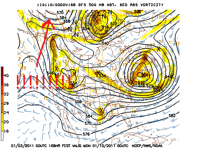
While the 12z gfs was not as strong the 6z and many runs before that showed a very strong high dropping down
6z:


12z has the cold air going east but check out the top left hand corner.

6z:
12z has the cold air going east but check out the top left hand corner.
For Your Infinite Source For All Things Weather Visit Our Facebook
-
Baseballdude2915
- Posts: 192
- Joined: Wed Feb 03, 2010 5:21 pm
- Location: Dickinson, Tx
- Contact:
Well, all of this just means one thing, winter is far from over...
Should have one or two strong shots of cold air, certainly a pattern change for this winter.
Just for kicks, the 18z GFS shows 15 degrees at 384 hours out. LOL.
Should have one or two strong shots of cold air, certainly a pattern change for this winter.
Just for kicks, the 18z GFS shows 15 degrees at 384 hours out. LOL.
-
Paul

- Posts: 535
- Joined: Wed Feb 03, 2010 11:46 pm
- Location: Pearland
- Contact:
just looked at the 18z GFS..nothing really catching my eye in the reality range....though with a lot of guidance hinting I just about to jump on board. too much model support not to....
-
sleetstorm
- Posts: 651
- Joined: Thu Feb 04, 2010 12:33 pm
- Contact:
What are the chances that precipitation will be associated with this surge of arctic air?
-
wxman57
- Global Moderator
- Posts: 2621
- Joined: Thu Feb 04, 2010 5:34 am
- Location: Southwest Houston (Westbury)
- Contact:
I'm seeing 21F at 6am on the 18th at IAH on the 18Z GFS, with 24F at 6pm that day. Of course, that's at the end of 16 days. Remember that the GFS just 3-4 days ago was forecasting snow here this coming weekend, now it is forecasting 50s and rain.Baseballdude2915 wrote:Well, all of this just means one thing, winter is far from over...
Should have one or two strong shots of cold air, certainly a pattern change for this winter.
Just for kicks, the 18z GFS shows 15 degrees at 384 hours out. LOL.
But there is some very cold air building in Canada. Might have a shot at a hard freeze here. Frozen precip is always quite difficult to get down here. The pattern that brings the cold air down may not be one to produce precip in the cold air.


-
Mr. T

- Posts: 992
- Joined: Wed Feb 03, 2010 4:22 pm
- Location: Kingwood
- Contact:
Heights on the 0z GFS for day 7 are lower in Houston, TX than northern areas of Alaska
That is a big time signal for some serious cold coming for the Lower 48...
0z GFS upper pattern day 7+ looks like the 12z Euro days 7-10. We probably have another arctic outbreak on the way... I was a bit skeptical at first, but these signals are hard to ignore.
That is a big time signal for some serious cold coming for the Lower 48...
0z GFS upper pattern day 7+ looks like the 12z Euro days 7-10. We probably have another arctic outbreak on the way... I was a bit skeptical at first, but these signals are hard to ignore.
Last edited by Mr. T on Sun Jan 02, 2011 10:52 pm, edited 1 time in total.
-
Ptarmigan
- Statistical Specialist
- Posts: 4513
- Joined: Wed Feb 03, 2010 7:20 pm
- Contact:
That's still very cold with the average temperature of 22F! That would be one of the coldest days in quite some times, if not coldest day on record.wxman57 wrote:
I'm seeing 21F at 6am on the 18th at IAH on the 18Z GFS, with 24F at 6pm that day. Of course, that's at the end of 16 days. Remember that the GFS just 3-4 days ago was forecasting snow here this coming weekend, now it is forecasting 50s and rain.
But there is some very cold air building in Canada. Might have a shot at a hard freeze here. Frozen precip is always quite difficult to get down here. The pattern that brings the cold air down may not be one to produce precip in the cold air.
Last edited by Ptarmigan on Sun Jan 02, 2011 10:56 pm, edited 2 times in total.
-
Ptarmigan
- Statistical Specialist
- Posts: 4513
- Joined: Wed Feb 03, 2010 7:20 pm
- Contact:
I have seen models that far out, as far as 16 days and they have been right in the past. Something tells me we will see a major Arctic blast.Mr. T wrote:Heights on the 0z GFS for day 7 are lower in Houston, TX than northern areas of Alaska
That is a big time signal for some serious cold coming for the Lower 48...
0z GFS upper pattern day 7+ looks like the 12z Euro days 7-10. We probably have another arctic outbreak on the way... I was a bit skeptical at first, but these signals are hard to ignore.

-
Ptarmigan
- Statistical Specialist
- Posts: 4513
- Joined: Wed Feb 03, 2010 7:20 pm
- Contact:
Looks to be a rainy one.Andrew wrote:Also something to look at for the shorter range is the low that tracks across SE Texas at hour 162:
http://www.nco.ncep.noaa.gov/pmb/nwprod ... p_162l.gif
-
Mr. T
- Posts: 992
- Joined: Wed Feb 03, 2010 4:22 pm
- Location: Kingwood
- Contact:
I'm not sure why I see all these posts about surface temperature forecasts from the GFS beyond day 7... That's not what's important here
Any basic knowledge of pattern recognition at day 7 should be good enough for anyone to see that we will likely have a couple of heavy arctic dumps for the Lower 48 on the way.
There's been a few musings on other forums from the experts that this upcoming period for mid to late January may be one of the coldest on record for the United States.
Last edited by Mr. T on Sun Jan 02, 2011 11:07 pm, edited 1 time in total.
-
Mr. T
- Posts: 992
- Joined: Wed Feb 03, 2010 4:22 pm
- Location: Kingwood
- Contact:
To be honest, I wouldn't care if the GFS was showing a blowtorch at this point after day 7. Just look at what the Pacific pattern is about to do this week... This should be enough to tell everyone that a major cold pattern is developing.Ptarmigan wrote: I have seen models that far out, as far as 16 days and they have been right in the past. Something tells me we will see a major Arctic blast.
In fact, this pattern will be similar to the first 15 days of January last year. However, it could be colder across the Lower 48 as, unlike last year, we will actually have an established cross polar flow that should bring about much colder air into Canada than what we saw at any point last year... With the polar vortex moving on our side of the pole (forecasted by the GFS and Euro), we may see records fall across a large area of the US.