
February Weather Discussion. Wild Winter Storms?
-
txflagwaver

- Posts: 411
- Joined: Wed Feb 03, 2010 2:37 pm
- Location: Seabrook/Kemah
- Contact:
has been raining off and on since about 10am...heavy rain but not really stormy...
-
sleetstorm
- Posts: 651
- Joined: Thu Feb 04, 2010 12:33 pm
- Contact:
So, how many models have been in our favor for the feasibility of receiving sleet/snow during the day after tomorrow into Wed morning, thus far, srainhoutx, Mr. T, Portastorm & wxdata?
Last edited by sleetstorm on Sun Feb 21, 2010 11:23 am, edited 3 times in total.
-
sleetstorm
- Posts: 651
- Joined: Thu Feb 04, 2010 12:33 pm
- Contact:
And that is good for people who live in south and southeast Texas who would very much like to get snow/sleet prior everything is all said and done for this go around of winter, yes?srainhoutx wrote:Just a word of caution concerning what we have seen ALL winter season. The closer to the event the more it does seem that everything shifts a bit further S than progged at 48 hours. I'm pulling for you Portastorm and all of us that seen nothing so far this winter season.
-
Rich
- Posts: 79
- Joined: Fri Feb 19, 2010 9:38 pm
- Location: Pearland,Tx
- Contact:
This run seems to be one of the furthest south runs I have seen for this event in regards to accumulating snow CHANCES for Houston, according to this graphic! http://wxcaster.com/gis-gfs-snow-overla ... TIONID=GRK
-
srainhoutx

- Site Admin

- Posts: 19700
- Joined: Tue Feb 02, 2010 2:32 pm
- Location: Maggie Valley, NC
- Contact:
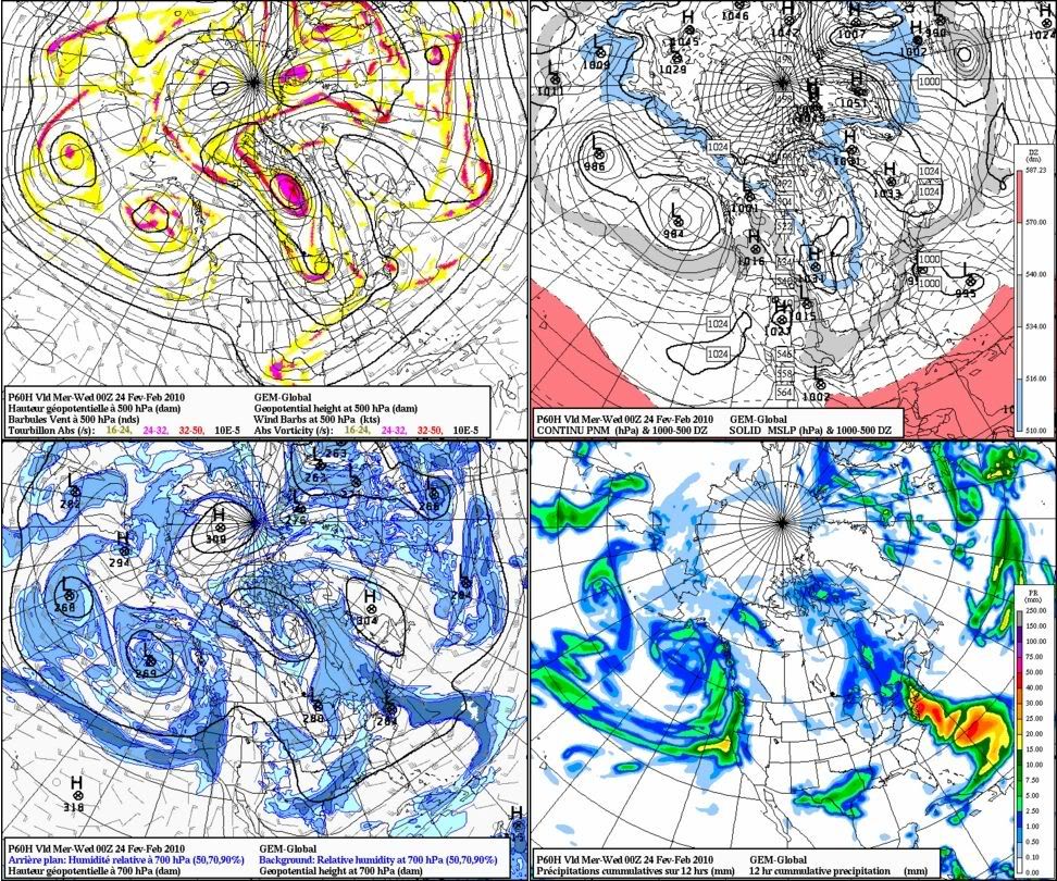
GGEM is interesting as well...
Carla/Alicia/Jerry(In The Eye)/Michelle/Charley/Ivan/Dennis/Katrina/Rita/Wilma/Humberto/Ike/Harvey
Member: National Weather Association
Facebook.com/Weather Infinity
Twitter @WeatherInfinity
Member: National Weather Association
Facebook.com/Weather Infinity
Twitter @WeatherInfinity
-
C2G

- Posts: 236
- Joined: Wed Feb 03, 2010 8:55 pm
- Location: NW Galveston County
- Contact:
That's interesting, but it only shows the Houston area maybe getting a flake or two..........barely just barely even in the area expected to get significant accumulation.Rich wrote:This run seems to be one of the furthest south runs I have seen for this event in regards to accumulating snow CHANCES for Houston, according to this graphic!
Cold rain with maybe a flake or two at the end of the event.
-
wxman57

- Global Moderator

- Posts: 2621
- Joined: Thu Feb 04, 2010 5:34 am
- Location: Southwest Houston (Westbury)
- Contact:
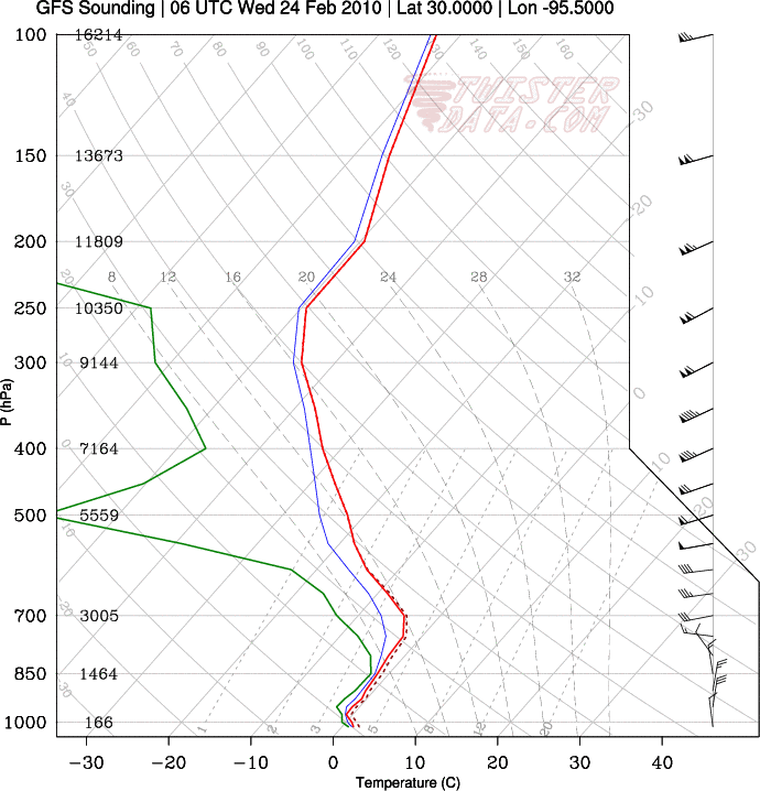
12Z GFS is certainly farther south with the snow line, but it's not really colder. First, take a look at the latest GFS meteogram for IAH (northern Houston). Note that all the precip falls while the surface temperature is between 35-39 degrees at the surface. That relatively warm air and high dew point at the start of the precip here really bothers me if I'm looking for snow. I'd like to see that green dew point line down at least below 25F at the start of the precip, and preferably closer to 18-20F.

Now look at a projected sounding from the same GFS, but for a bit to the northwest of Houston in northwest Harris County. It's still borderline for snow to reach the ground, and the surface temperature is well up into the 30s.

So I think we'll be borderline for snow across most of the city. Mostly cold rain, occasionally mixed with sleet from mid to late afternoon. Maybe a few snowflakes as the precip ends, but they'd melt upon hitting the above-freezing ground. There's just nothing to indicate that the airmass will be cold enough here for accumulating snow. Just not quite cold enough at the ground and aloft.
Now, it's possible that the "aloft" air will be a little cooler than forecast, but that would still leave the surface air too warm. I think it's less likely that the models are off by 5-7 degrees on the surface temps, though. That relatively warm air and high dew point at the start of the precip here really bothers me if I'm looking for snow.
Now look at a projected sounding from the same GFS, but for a bit to the northwest of Houston in northwest Harris County. It's still borderline for snow to reach the ground, and the surface temperature is well up into the 30s.
So I think we'll be borderline for snow across most of the city. Mostly cold rain, occasionally mixed with sleet from mid to late afternoon. Maybe a few snowflakes as the precip ends, but they'd melt upon hitting the above-freezing ground. There's just nothing to indicate that the airmass will be cold enough here for accumulating snow. Just not quite cold enough at the ground and aloft.
Now, it's possible that the "aloft" air will be a little cooler than forecast, but that would still leave the surface air too warm. I think it's less likely that the models are off by 5-7 degrees on the surface temps, though. That relatively warm air and high dew point at the start of the precip here really bothers me if I'm looking for snow.
-
txsnowmaker
- Posts: 733
- Joined: Wed Feb 03, 2010 4:07 pm
- Location: SW Houston (Galleria area)
- Contact:
I realize that I may be going against some current model soundings, but as we are still more than 48 hours out, I myself am not yet ready to foreclose the possibility of more than a few flakes that melt on impact. Maybe we will get enough that it will stay on the ground even if surface temps are a little too high i.e. 2008.
-
srainhoutx
- Site Admin
- Posts: 19700
- Joined: Tue Feb 02, 2010 2:32 pm
- Location: Maggie Valley, NC
- Contact:
Wait until wxman57 post the data for Austin and Portastorm. That should get things going. 
Carla/Alicia/Jerry(In The Eye)/Michelle/Charley/Ivan/Dennis/Katrina/Rita/Wilma/Humberto/Ike/Harvey
Member: National Weather Association
Facebook.com/Weather Infinity
Twitter @WeatherInfinity
Member: National Weather Association
Facebook.com/Weather Infinity
Twitter @WeatherInfinity
-
don

- Posts: 3148
- Joined: Wed Feb 03, 2010 3:33 pm
- Location: Wichita Falls
- Contact:
I agree also i still thinks theres a chance of accumulating snow as far south as the I-10 corridor. even if only .50-1 inch at the most.Not the most likely scenario but it cant be ruled out also.
SIDENOTE: Ed Mahmoud heres the link to the image: http://www.twisterdata.com/data/models/ ... URFACE.png
And heres the link to the site: http://www.twisterdata.com/index.php?pr ... hive=false
SIDENOTE: Ed Mahmoud heres the link to the image: http://www.twisterdata.com/data/models/ ... URFACE.png
And heres the link to the site: http://www.twisterdata.com/index.php?pr ... hive=false
-
wxdata

- Site Admin
- Posts: 1059
- Joined: Wed Feb 03, 2010 3:04 pm
- Location: Houston, TX
- Contact:
Snow in Texas 12z NAM vs 12z GFS
-
txsnowmaker
- Posts: 733
- Joined: Wed Feb 03, 2010 4:07 pm
- Location: SW Houston (Galleria area)
- Contact:
wxdata wrote:Snow in Texas 12z NAM vs 12z GFS
Interesting wxdata, especially since the NAM can be biased on the "warm" side.
-
wxman57
- Global Moderator
- Posts: 2621
- Joined: Thu Feb 04, 2010 5:34 am
- Location: Southwest Houston (Westbury)
- Contact:
Here's the 'Portastorm" snowfall map I posted at S2K:
Everything (currently) indicates you'll be getting a few inches of snow out of this storm. I made a special sounding for you. The sounding is valid for NOON Tuesday! The accumulation map is valid for midnight Tuesday night. It looks like an extended period of snow in Austin.

Everything (currently) indicates you'll be getting a few inches of snow out of this storm. I made a special sounding for you. The sounding is valid for NOON Tuesday! The accumulation map is valid for midnight Tuesday night. It looks like an extended period of snow in Austin.
-
wxman57
- Global Moderator
- Posts: 2621
- Joined: Thu Feb 04, 2010 5:34 am
- Location: Southwest Houston (Westbury)
- Contact:
Here's the link:Ed Mahmoud wrote: Can I get the URL for that snow fall happy map. I don't want to just Hotlink your cableone.net image, as I want to post it on a patriotic political forum which has members from parts of Texas who get interesting weather more than once a year.
http://www.twisterdata.com/
From the main page, click "GFS" on the top navigation bar and "Winter" in the lower left frame then "Snow Depth" in the new menu that appears below "Winter" You'll see a map like this:

Note that in the example, I have the 66hr forecast selected. Just click any green square at the upper left to go to a different time period. To get a sounding, just click in the approximate location on the map and a sounding appears with a google map to the side, allowing you to pinpoint the sounding locaction:

Zoom in on an area so you can see where you're plotting the sounding for. Drag the little marker around then click "Get new Sounding". It's not THAT precise. For example, it wouldn't let me make one for SW Houston. It was either NW Houston or far SW Houston. But it's close enough.
The combined maps I'm posting are made with an image editor. I blow up the sounding and the U.S. snowfall map, cut out Texas and paste it on the blow-up of the sounding.
-
brazoria_county22
- Posts: 61
- Joined: Thu Feb 04, 2010 6:39 am
- Location: angleton,tx
- Contact:
so nothing but a cold rain for us n brazoria county im guessing? 
-
TexasMetBlake
- Pro Met

- Posts: 839
- Joined: Wed Feb 03, 2010 7:03 pm
- Location: Spring/Woodlands
- Contact:
Hey, don't roll your eyes at us!brazoria_county22 wrote:so nothing but a cold rain for us n brazoria county im guessing?
-
srainhoutx
- Site Admin
- Posts: 19700
- Joined: Tue Feb 02, 2010 2:32 pm
- Location: Maggie Valley, NC
- Contact:
Conroe...since we're posting soundings...at this rate (48 hours out) Portastorm will be in the "bulls eye" and NW Harris County will be in the 1-2 range...
Carla/Alicia/Jerry(In The Eye)/Michelle/Charley/Ivan/Dennis/Katrina/Rita/Wilma/Humberto/Ike/Harvey
Member: National Weather Association
Facebook.com/Weather Infinity
Twitter @WeatherInfinity
Member: National Weather Association
Facebook.com/Weather Infinity
Twitter @WeatherInfinity
-
TexasMetBlake
- Pro Met
- Posts: 839
- Joined: Wed Feb 03, 2010 7:03 pm
- Location: Spring/Woodlands
- Contact:
Wow, that's good for Conroe. How are they getting this data? Is it extrapolated from KLCH and KCPS?
-
wxman57
- Global Moderator
- Posts: 2621
- Joined: Thu Feb 04, 2010 5:34 am
- Location: Southwest Houston (Westbury)
- Contact:
Try 3-6 hours earlier for a sounding, srain. Looks like precip has ended at the time of that sounding. Lots of drying aloft.srainhoutx wrote:Conroe...since we're posting soundings...at this rate (48 hours out) Portastorm will be in the "bulls eye" and NW Harris County will be in the 1-2 range...
http://i228.photobucket.com/albums/ee29 ... 3_2010.png
-
wxman57
- Global Moderator
- Posts: 2621
- Joined: Thu Feb 04, 2010 5:34 am
- Location: Southwest Houston (Westbury)
- Contact:
These are model soundings, made off the latest GFS, RUC or NAM. They're not extrapolated between LCH-CRP, they're forecast soundings for any time up to 16 days from now.Candy Cane wrote:Wow, that's good for Conroe. How are they getting this data? Is it extrapolated from KLCH and KCPS?