
Today is the worst yet. It's the temperature of the solar surface out there!
103.6°F and rising.
A sliver of hope. Euro and GFs-AI bring a back door front in at the end of the first week in September for the Labor Day weekend.
August 2026
-
DoctorMu

- Posts: 8133
- Joined: Sun Jun 28, 2015 11:58 am
- Location: College Station
- Contact:
-
user:null
- Posts: 470
- Joined: Fri Jul 01, 2022 7:04 pm
- Location: The Land of Sugar
- Contact:
Looking at models, it looks like the presence/absence of rain (at least, for the sea-level elevations) is correlated with the 582 thickness line.
-
DoctorMu
- Posts: 8133
- Joined: Sun Jun 28, 2015 11:58 am
- Location: College Station
- Contact:
Dayum - 107°F at the casa.
Renegade showers headed for Conroe and NW Harris Co. Will they make it?
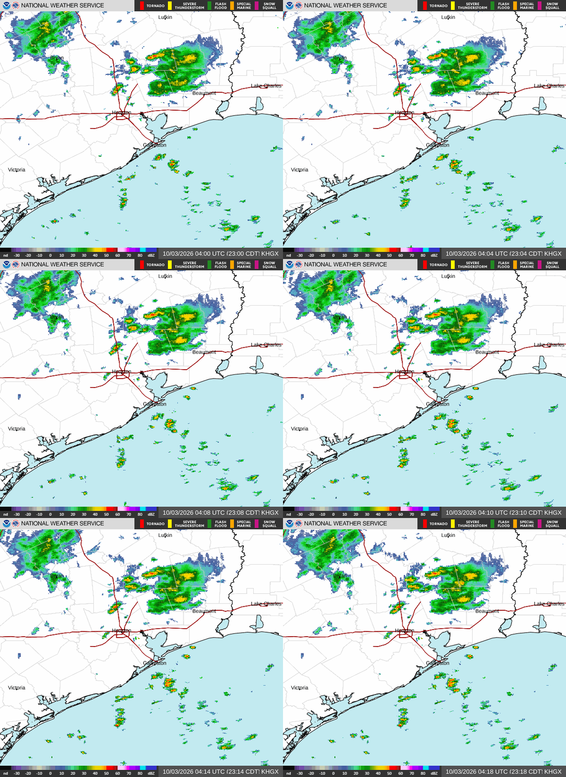
Renegade showers headed for Conroe and NW Harris Co. Will they make it?
-
mcheer23
- Global Moderator

- Posts: 608
- Joined: Fri Jan 11, 2013 11:15 am
- Location: Missouri City/ Sugar Land
- Contact:
KSGR reporting 108
-
user:null
- Posts: 470
- Joined: Fri Jul 01, 2022 7:04 pm
- Location: The Land of Sugar
- Contact:
-
TxLady

- Posts: 113
- Joined: Thu Feb 04, 2010 8:39 am
- Location: New Waverly, Walker Co., TX
- Contact:
Hallelujah!! The rain turtle/dance worked! A nice little thunderstorm and rained for about an hour!
-
Cpv17
- Posts: 7126
- Joined: Fri Aug 31, 2018 1:58 pm
- Location: El Campo/Wharton
- Contact:
-
Stratton20
- Posts: 5887
- Joined: Tue Feb 09, 2021 11:35 pm
- Location: College Station, Texas
- Contact:
abc13 has daily 20-30% rain chances starting wednesday and beyond, and highs only in the “ Upper 90’s “ Lol, maybe there is some room for hope
-
user:null
- Posts: 470
- Joined: Fri Jul 01, 2022 7:04 pm
- Location: The Land of Sugar
- Contact:
According to this X/Twitter post, this heat ridge (and others that manifested in previous years into Texas) looks tied to activity in the Eastern Tropical Pacific. It looks like a new opportunity for a study (regarding signals for hotter/cooler summers in Texas):
https://x.com/webberweather/status/2091148206214467952
https://x.com/webberweather/status/2091148206214467952
-
davidiowx
- Posts: 1198
- Joined: Thu Jan 23, 2014 2:39 pm
- Location: Richmond, TX
- Contact:
Nothing is broken, if you aren’t familiar with the area, KSGR is literally surrounded by marsh/swamp. It’s going to have a “wetter” surface climate. I’m in the Pecan Grove area it far away and I hit 105.6 with a dew point 77+ all day. Heat index was well into the 120s
-
user:null
- Posts: 470
- Joined: Fri Jul 01, 2022 7:04 pm
- Location: The Land of Sugar
- Contact:
If anything, surrounding marsh/swamp/etc would make the area cooler. Hence, that makes the temperature reading even more suspect (especially when literal urban heat islands were nowhere near as hot).davidiowx wrote: ↑Sun Aug 23, 2026 11:33 amNothing is broken, if you aren’t familiar with the area, KSGR is literally surrounded by marsh/swamp. It’s going to have a “wetter” surface climate. I’m in the Pecan Grove area it far away and I hit 105.6 with a dew point 77+ all day. Heat index was well into the 120s
-
Cpv17
- Posts: 7126
- Joined: Fri Aug 31, 2018 1:58 pm
- Location: El Campo/Wharton
- Contact:
Yeah, you would think it would make the temps a bit cooler, but the humidity a bit higher.user:null wrote: ↑Sun Aug 23, 2026 12:13 pmIf anything, surrounding marsh/swamp/etc would make the area cooler. Hence, that makes the temperature reading even more suspect (especially when literal urban heat islands were nowhere near as hot).davidiowx wrote: ↑Sun Aug 23, 2026 11:33 amNothing is broken, if you aren’t familiar with the area, KSGR is literally surrounded by marsh/swamp. It’s going to have a “wetter” surface climate. I’m in the Pecan Grove area it far away and I hit 105.6 with a dew point 77+ all day. Heat index was well into the 120s
-
Cpv17
- Posts: 7126
- Joined: Fri Aug 31, 2018 1:58 pm
- Location: El Campo/Wharton
- Contact:
That’s freaking nuts man. The heat index at my house yesterday maxed out at 109. I live out in the country surrounded by pastures and crops. It usually doesn’t get nearly as hot where I live compared to a lot of other places in SETX.davidiowx wrote: ↑Sun Aug 23, 2026 11:33 amNothing is broken, if you aren’t familiar with the area, KSGR is literally surrounded by marsh/swamp. It’s going to have a “wetter” surface climate. I’m in the Pecan Grove area it far away and I hit 105.6 with a dew point 77+ all day. Heat index was well into the 120s
-
jasons2k

- Posts: 6211
- Joined: Thu Feb 04, 2010 12:54 pm
- Location: Imperial Oaks
- Contact:
I’m at 103 now after a cloudy morning. This was yesterday - 107.
This is on a Davis station, too.
This is on a Davis station, too.
- Attachments
-
- IMG_2184.jpeg
- (371.12 KiB) Not downloaded yet
-
captainbarbossa19

- Pro Met

- Posts: 463
- Joined: Mon Jun 28, 2021 2:50 pm
- Location: Conroe, TX
- Contact:
I personally think it may be cooler than that. High pressure really starts backing off by around Thursday. Should see storms sliding around ridge into our region later this upcoming week.Stratton20 wrote: ↑Sat Aug 22, 2026 9:48 pm abc13 has daily 20-30% rain chances starting wednesday and beyond, and highs only in the “ Upper 90’s “ Lol, maybe there is some room for hope
-
user:null
- Posts: 470
- Joined: Fri Jul 01, 2022 7:04 pm
- Location: The Land of Sugar
- Contact:
Yea, that's why I'm having my eye on the Sugar Land location. The readings are off, as conditions shouldn't be too different from nearby Arcola/Sienna, as well as your location (Wharton or El Campo?).
-
DoctorMu
- Posts: 8133
- Joined: Sun Jun 28, 2015 11:58 am
- Location: College Station
- Contact:
Racked up another 107°F at the casa. 106°F at the airport. Yeah, I also thought the morning cloud cover would give us a break.
Showers are moving south near the LA border on the eastern edge of the ridge. No luck here.
Only a 20% chance of showers Thursday and Friday in HOU and CLL. We *might* dip below 100°F, The Big Suck continues. Aggie climo tradition has been revoked.
Not counting on anything.
.DISCUSSION...
Issued at 133 PM CDT Sun Aug 23 2026
Temperatures are currently running 2-5 degrees lower than yesterday
at this time thanks to the debris cloudiness passing overhead.
Satellite pix show the sun re-emerging so we still have plenty of
time to get some of those readings back close to 100F. Like
previous days, cannot rule out an isolated storm or two late in
the day/evening. Consider yourself lucky if one passes overhead as
most of us will remain dry.
If you`ve enjoyed the wx for the past several days, you`re in for
a treat because more of the same is anticipated thru at least
midweek. Will maintain the ongoing Heat Advisories in place.
Later in the week (Thursday and beyond), the western mid-upper
ridge moves a bit further to the west which will allow for falling
heights locally and a gradual easing of the 100F+ temps. It appears
that llvl ridging in the Gulf will also lose some of its grip. A
more prevalent SSE flow emerges (versus the current SW) and opens
up a better trajectory for some higher PW Gulf air to flow
inland. Combination of this, less potent subsidence aloft, and
some east-to-west mid level impulses should allow for the mention
of some POPs to return to the fcst. Suspect we`ll see rain
chances trend higher than we currently have in our fcst assuming
the wetter 12z deterministic model suites show some consistency as
time marches on. 47