
June 2026
-
tireman4

- Global Moderator

- Posts: 7169
- Joined: Wed Feb 03, 2010 9:24 pm
- Location: Humble, Texas
- Contact:
What shall we see? Hot? Wet? Cool?
-
Pas_Bon
- Posts: 976
- Joined: Tue Sep 11, 2018 7:58 am
- Location: League City, TX
- Contact:
I say this about every month, but if I see temps >90°, I’m suing. Is it October yet? 

-
DoctorMu

- Posts: 8127
- Joined: Sun Jun 28, 2015 11:58 am
- Location: College Station
- Contact:
Hot. The spigot turns off sometime during the month.
-
Stratton20
- Posts: 5885
- Joined: Tue Feb 09, 2021 11:35 pm
- Location: College Station, Texas
- Contact:
Wet weather persists through the entirety of June, this will be added by another WWB in the pacific, think above normal precipitation continues through all of summer, this el nino is different
-
tireman4
- Global Moderator
- Posts: 7169
- Joined: Wed Feb 03, 2010 9:24 pm
- Location: Humble, Texas
- Contact:
Travis Herzog on Facebook
Eye on the Gulf Next Week
I'm going to start gently raising your awareness about the potential for a mess of tropical moisture to soak part of the U.S. Gulf Coast next week.
We anticipate a surge of tropical moisture will fill the western half of the Gulf after the weekend, and low pressure may attempt to spin up in the vicinity. While hurricane season does begin Monday, wind shear across the Gulf will remain fairly high through this time period, so I am not concerned about a hurricane. But could a lopsided tropical depression or low-end tropical storm develop? Maybe.
Regardless of development, the main point is we don't yet have a good feel for exactly where this moisture and its tropical downpours will go, so at this time I simply encourage you to stay looped in to the forecast. Wherever that moisture crosses over land, flash flooding will be the primary concern.
We'll keep you posted.
Full forecast for Houston: abc13.com/forecast
Eye on the Gulf Next Week
I'm going to start gently raising your awareness about the potential for a mess of tropical moisture to soak part of the U.S. Gulf Coast next week.
We anticipate a surge of tropical moisture will fill the western half of the Gulf after the weekend, and low pressure may attempt to spin up in the vicinity. While hurricane season does begin Monday, wind shear across the Gulf will remain fairly high through this time period, so I am not concerned about a hurricane. But could a lopsided tropical depression or low-end tropical storm develop? Maybe.
Regardless of development, the main point is we don't yet have a good feel for exactly where this moisture and its tropical downpours will go, so at this time I simply encourage you to stay looped in to the forecast. Wherever that moisture crosses over land, flash flooding will be the primary concern.
We'll keep you posted.
Full forecast for Houston: abc13.com/forecast
- Attachments
-
- FB_IMG_1780145948958.jpg
- (112.22 KiB) Not downloaded yet
-
tireman4
- Global Moderator
- Posts: 7169
- Joined: Wed Feb 03, 2010 9:24 pm
- Location: Humble, Texas
- Contact:
A met in New Orleans posted this. We are a long way away Day 16 of models hinting at a low-pressure system in the Gulf during the first week of June.
The usually more level-headed Euro model (see picture below) is still showing some spin trying to get its act together in the western Gulf next week. A sizable amount of wind shear is expected to be present across the eastern Gulf, so we may end up with nothing more than a sloppy system featuring gusty winds and heavy rain.
There’s still plenty of time to iron this out, but consider this your friendly reminder that hurricane season starts Monday. Your next reminder may not be quite as friendly. If something does get named, Arthur would be first up.
Stay prepared. Stay sexy.
The usually more level-headed Euro model (see picture below) is still showing some spin trying to get its act together in the western Gulf next week. A sizable amount of wind shear is expected to be present across the eastern Gulf, so we may end up with nothing more than a sloppy system featuring gusty winds and heavy rain.
There’s still plenty of time to iron this out, but consider this your friendly reminder that hurricane season starts Monday. Your next reminder may not be quite as friendly. If something does get named, Arthur would be first up.
Stay prepared. Stay sexy.
- Attachments
-
- FB_IMG_1780145948958.jpg
- (112.22 KiB) Not downloaded yet
-
- FB_IMG_1780157567331.jpg
- (141 KiB) Not downloaded yet
-
DoctorMu
- Posts: 8127
- Joined: Sun Jun 28, 2015 11:58 am
- Location: College Station
- Contact:
The CMC, GFS, Euro have a pretty unsettled mid to late week in Texas. Back door FROPA couple with gulf moisture, I approve this message..
-
DoctorMu
- Posts: 8127
- Joined: Sun Jun 28, 2015 11:58 am
- Location: College Station
- Contact:
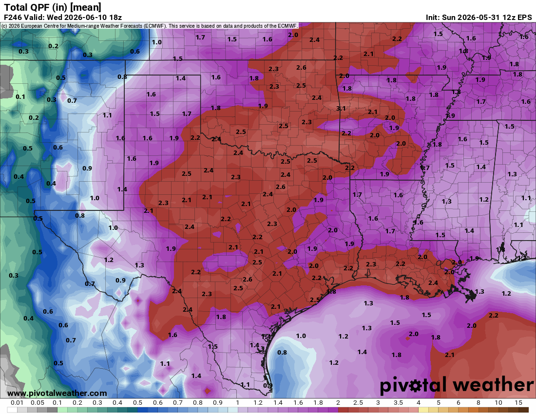
A couple of inches of rain in the next 10 days on the Ensembles - I'll sign up for that.

- Attachments
-
- gem-ens_apcpn_us_30.png
- (112.19 KiB) Not downloaded yet
-
- qpf_acc-mean-imp.us_sc-2.png
- (320.92 KiB) Not downloaded yet
-
Cpv17
- Posts: 7118
- Joined: Fri Aug 31, 2018 1:58 pm
- Location: El Campo/Wharton
- Contact:
-
Ptarmigan
- Statistical Specialist

- Posts: 4545
- Joined: Wed Feb 03, 2010 7:20 pm
- Contact:
-
Cpv17
- Posts: 7118
- Joined: Fri Aug 31, 2018 1:58 pm
- Location: El Campo/Wharton
- Contact:
Good point. They already increased totals on their last update.
-
tireman4
- Global Moderator
- Posts: 7169
- Joined: Wed Feb 03, 2010 9:24 pm
- Location: Humble, Texas
- Contact:
Travis Herzog on Facebook
Time to bring the umbrellas back out!
Tropical moisture is blowing in from the Gulf, and that will lead to a scattering of afternoon downpours most days on this first week of June.
The moisture associated with the storminess down near the Yucatan will eventually find its way toward Texas and Louisiana late this week, and there is room for our rain chances to go higher Friday through Sunday.
Wind shear is still very high over the Gulf, so it's unlikely anything develops. Regardless of any low pressure spin up, the end result should be about the same: disorganized tropical downpours soak some of us later this week. We'll keep you posted.
Full forecast: abc13.com/forecast
Time to bring the umbrellas back out!
Tropical moisture is blowing in from the Gulf, and that will lead to a scattering of afternoon downpours most days on this first week of June.
The moisture associated with the storminess down near the Yucatan will eventually find its way toward Texas and Louisiana late this week, and there is room for our rain chances to go higher Friday through Sunday.
Wind shear is still very high over the Gulf, so it's unlikely anything develops. Regardless of any low pressure spin up, the end result should be about the same: disorganized tropical downpours soak some of us later this week. We'll keep you posted.
Full forecast: abc13.com/forecast
- Attachments
-
- FB_IMG_1780319720363.jpg
- (80.44 KiB) Not downloaded yet
-
- FB_IMG_1780319709189.jpg
- (111.86 KiB) Not downloaded yet
-
- FB_IMG_1780319704828.jpg
- (74.95 KiB) Not downloaded yet
-
DoctorMu
- Posts: 8127
- Joined: Sun Jun 28, 2015 11:58 am
- Location: College Station
- Contact:
Hmmmm...NOAA has higher chances of rain for College Station (60% Thursday, Friday; 70% Saturday) - There's a backdoor FROPA due to ease toward us late in the week that could, with Gulf moisture in place, trigger more showers. Fingers crossed. I'm trying to hold off on running the sprinkler system with our sodium and calcium carbonate-filled water (aka alkaline poison).
-
tireman4
- Global Moderator
- Posts: 7169
- Joined: Wed Feb 03, 2010 9:24 pm
- Location: Humble, Texas
- Contact:
-
tireman4
- Global Moderator
- Posts: 7169
- Joined: Wed Feb 03, 2010 9:24 pm
- Location: Humble, Texas
- Contact:
-
DoctorMu
- Posts: 8127
- Joined: Sun Jun 28, 2015 11:58 am
- Location: College Station
- Contact:
With that weak backdoor front easing through...NE flow is building...at least in CLL...don't be surprised if showers appear late in the afternoon and evening coming down from Texarkana, Tyler, and scattered around. Not a lot of QPF with these, but a welcome summer shower will get no argument from me.
After Wednesday, more tropical flow appears to be in our future. Combined with an ULL from Baja, there could be a trigger for more showers late week and into the weekend.
.
After Wednesday, more tropical flow appears to be in our future. Combined with an ULL from Baja, there could be a trigger for more showers late week and into the weekend.
.
-
jasons2k

- Posts: 6210
- Joined: Thu Feb 04, 2010 12:54 pm
- Location: Imperial Oaks
- Contact:
Stormy
- Attachments
-
- IMG_9924.png
- (5.07 MiB) Not downloaded yet
-
Rip76

- Posts: 2154
- Joined: Mon Feb 15, 2010 12:38 am
- Location: The Woodlands
- Contact:
Getting crushed on 99 and 249.
-
Cpv17
- Posts: 7118
- Joined: Fri Aug 31, 2018 1:58 pm
- Location: El Campo/Wharton
- Contact:
That’s one strong looking storm on radar stretching from Wallis to Richmond. Hope it doesn’t fizzle out before it gets here.