
Tropical Discussion 2025
-
Ptarmigan

- Statistical Specialist

- Posts: 4519
- Joined: Wed Feb 03, 2010 7:20 pm
- Contact:
-
Ptarmigan
- Statistical Specialist
- Posts: 4519
- Joined: Wed Feb 03, 2010 7:20 pm
- Contact:
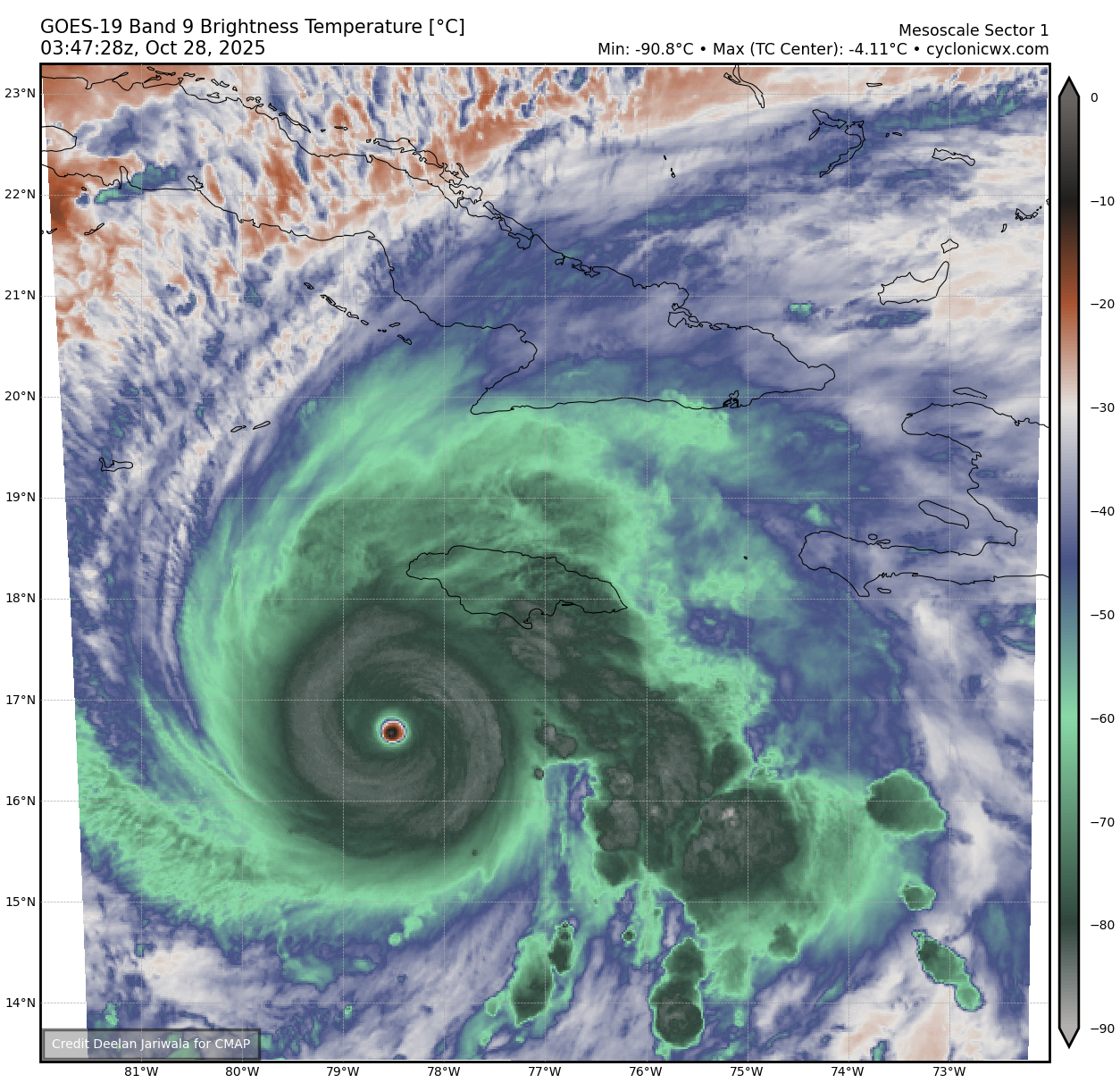
Dropsonde has 902 millibar with 22 knot winds. Melissa likely has 900 millibar central pressure. That is more intense than Katrina.

-
Cromagnum
- Posts: 3065
- Joined: Thu Feb 03, 2011 10:42 pm
- Location: Georgetown
- Contact:
Down to 893 mb this morning. No words...
-
tireman4

- Global Moderator

- Posts: 7123
- Joined: Wed Feb 03, 2010 9:24 pm
- Location: Humble, Texas
- Contact:
- Melissa.jpg (58.36 KiB) Viewed 39621 times
-
Cromagnum
- Posts: 3065
- Joined: Thu Feb 03, 2011 10:42 pm
- Location: Georgetown
- Contact:
I have never seen such strong wording...

-
tireman4
- Global Moderator
- Posts: 7123
- Joined: Wed Feb 03, 2010 9:24 pm
- Location: Humble, Texas
- Contact:
-
tireman4
- Global Moderator
- Posts: 7123
- Joined: Wed Feb 03, 2010 9:24 pm
- Location: Humble, Texas
- Contact:
Jeremy DeHart
@JeremyDeHartWX
Looks like the very rough ride was confirmed. Plane had to leave early. They reported svr turb and a "sawtooth" eye. Looks like they moved 600-700ft up & down during this stretch in ~1 min. But they captured some historic data including a 893mb center drop. Mission for the ages.
@JeremyDeHartWX
Looks like the very rough ride was confirmed. Plane had to leave early. They reported svr turb and a "sawtooth" eye. Looks like they moved 600-700ft up & down during this stretch in ~1 min. But they captured some historic data including a 893mb center drop. Mission for the ages.
-
tireman4
- Global Moderator
- Posts: 7123
- Joined: Wed Feb 03, 2010 9:24 pm
- Location: Humble, Texas
- Contact:
Mark Sudduth
- Attachments
-
- Screenshot 2025-10-28 113547.jpg (84.13 KiB) Viewed 39576 times
-
DoctorMu

- Posts: 8016
- Joined: Sun Jun 28, 2015 11:58 am
- Location: College Station
- Contact:
Keep veering off!
892 mb and 185 mph Jeez - prayers for Jamaica.
892 mb and 185 mph Jeez - prayers for Jamaica.
-
Ptarmigan
- Statistical Specialist
- Posts: 4519
- Joined: Wed Feb 03, 2010 7:20 pm
- Contact:

I would not be surprised if Melissa was still intensifying upon landfall.
-
tireman4
- Global Moderator
- Posts: 7123
- Joined: Wed Feb 03, 2010 9:24 pm
- Location: Humble, Texas
- Contact:
Melissa
- Attachments
-
- Screenshot 2025-10-29 091317.jpg (75.43 KiB) Viewed 39476 times
-
- Screenshot 2025-10-29 091412.jpg (80.55 KiB) Viewed 39476 times
-
tireman4
- Global Moderator
- Posts: 7123
- Joined: Wed Feb 03, 2010 9:24 pm
- Location: Humble, Texas
- Contact:
000
WTNT43 KNHC 290852
TCDAT3
Hurricane Melissa Discussion Number 32
NWS National Hurricane Center Miami FL AL132025
500 AM EDT Wed Oct 29 2025
Radar data and satellite images indicate that Melissa made landfall
in the province of Santiago de Cuba to the east of Chivirico around
0710 UTC this morning. The estimated landfall intensity of 105 kt
was based on a blend of the earlier Air Force Hurricane Hunter wind
and pressure data with the available satellite intensity estimates.
The hurricane is now centered inland over eastern Cuba, where
damaging winds and heavy rainfall continue across the region. Outer
rainbands are also noted across Haiti and portions of the Bahamas
and Turks and Caicos. Land interaction with the rugged terrain of
eastern Cuba has likely caused some weakening over the past couple
of hours, so the initial intensity is lowered to 100 kt.
The hurricane is moving to the northeast at 10 kt within the flow
between an upper trough over the southeastern U.S. and a subtropical
ridge over the central Atlantic. After crossing eastern Cuba this
morning, Melissa is expected to continue accelerating northeastward
during the next several days. This motion will bring the core of the
hurricane over portions of the southeastern and central Bahamas
later today. Then, the track models are tightly clustered on the
center of Melissa passing to the west of Bermuda late Thursday and
Thursday night. With good overall model agreement, no notable
changes were made to this portion of the NHC track forecast. There
was a leftward shift in much of the guidance at 96-120 h, and the
official track forecast was adjusted to reflect these trends.
Additional weakening is expected while the hurricane moves across
eastern Cuba this morning. Melissa is expected to remain a strong
hurricane while it crosses portions of the Bahamas later today. Over
the next few days, increasing vertical wind shear, cooler waters,
and a drier surrounding mid-level environment will likely induce
further weakening. However, Melissa is forecast to still be a
hurricane when it makes it closest approach to Bermuda later this
week. Then, the global model fields and model-simulated satellite
imagery show Melissa quickly losing tropical characteristics and
becoming an extratropical cyclone by Friday night or early Saturday.
No major changes were made to the updated NHC intensity prediction,
which remains near the middle of the intensity guidance envelope.
Key Messages:
1. Jamaica: You may need to remain sheltered after the storm due to
downed power lines and flooded areas. Ensure generators are
properly ventilated and placed outside at least 20 feet away from
dwellings and garages to avoid carbon monoxide poisoning. During
clean up, be careful when using chainsaws and power tools. Drink
plenty of water to avoid heat exhaustion.
2. Haiti and the Dominican Republic: Catastrophic flash flooding and
landslides are expected across portions of Haiti and the Dominican
Republic through today. In Haiti, extensive damage and isolation of
communities is likely. Tropical storm conditions are expected
through this morning.
3. Eastern Cuba: Life-threatening storm surge, flash flooding and
landslides, and damaging hurricane winds are ongoing this morning.
Remain in a safe shelter.
4. Bahamas and the Turks and Caicos: Hurricane conditions,
life-threatening storm surge, and heavy rainfall are expected across
portions of the southeastern and central Bahamas today. Find a safe
shelter and follow local official guidance. Tropical storm
conditions, heavy rains, and significant storm surge are expected in
the Turks and Caicos Islands today.
5. Bermuda: Hurricane conditions and heavy rainfall are possible in
Bermuda beginning Thursday or Thursday night.
FORECAST POSITIONS AND MAX WINDS
INIT 29/0900Z 20.3N 76.1W 100 KT 115 MPH
12H 29/1800Z 21.9N 75.1W 95 KT 110 MPH
24H 30/0600Z 25.0N 73.0W 90 KT 105 MPH
36H 30/1800Z 29.0N 69.9W 85 KT 100 MPH
48H 31/0600Z 34.2N 64.8W 80 KT 90 MPH
60H 31/1800Z 40.3N 58.1W 70 KT 80 MPH
72H 01/0600Z 46.3N 51.0W 60 KT 70 MPH...POST-TROP/EXTRATROP
96H 02/0600Z 53.5N 36.0W 50 KT 60 MPH...POST-TROP/EXTRATROP
120H 03/0600Z 58.0N 20.0W 40 KT 45 MPH...POST-TROP/EXTRATROP
$$
Forecaster Reinhart
-
tireman4
- Global Moderator
- Posts: 7123
- Joined: Wed Feb 03, 2010 9:24 pm
- Location: Humble, Texas
- Contact:
Ryan Maue
- Attachments
-
- Screenshot 2025-10-29 131525.png (332.79 KiB) Viewed 39458 times
-
tireman4
- Global Moderator
- Posts: 7123
- Joined: Wed Feb 03, 2010 9:24 pm
- Location: Humble, Texas
- Contact:
000
WTNT33 KNHC 291740
TCPAT3
BULLETIN
Hurricane Melissa Intermediate Advisory Number 33A
NWS National Hurricane Center Miami FL AL132025
200 PM EDT Wed Oct 29 2025
...DAMAGING WINDS, FLOODING RAINS, AND A DANGEROUS STORM SURGE
EXPECTED IN THE BAHAMAS THROUGH TONIGHT AND FOR THE AFTERNOON IN
EASTERN CUBA...
SUMMARY OF 200 PM EDT...1800 UTC...INFORMATION
----------------------------------------------
LOCATION...22.1N 75.3W
ABOUT 110 MI...175 KM SSE OF THE CENTRAL BAHAMAS
ABOUT 955 MI...1535 KM SW OF BERMUDA
MAXIMUM SUSTAINED WINDS...100 MPH...155 KM/H
PRESENT MOVEMENT...NE OR 35 DEGREES AT 15 MPH...24 KM/H
MINIMUM CENTRAL PRESSURE...974 MB...28.77 INCHES
WATCHES AND WARNINGS
--------------------
CHANGES WITH THIS ADVISORY:
None.
SUMMARY OF WATCHES AND WARNINGS IN EFFECT:
A Hurricane Warning is in effect for...
* Cuban provinces of Granma, Santiago de Cuba, Guantanamo,
Holguin, and Las Tunas
* Southeastern and Central Bahamas
* Bermuda
A Tropical Storm Warning is in effect for...
* Haiti
* Cuban province of Camaguey
* Turks and Caicos Islands
A Hurricane Warning means that hurricane conditions are expected
somewhere within the warning area. Residents in Cuba should remain
sheltered. In the Bahamas, residents should remain sheltered. In
Bermuda, preparations should be underway and be completed before
anticipated first occurrence of tropical-storm-force winds,
conditions that make outside preparations difficult or dangerous.
A Tropical Storm Warning means that tropical storm conditions are
expected somewhere within the warning area.
For storm information specific to your area, please monitor
products issued by your national meteorological service.
DISCUSSION AND OUTLOOK
----------------------
At 200 PM EDT (1800 UTC), the center of Hurricane Melissa was
located by Air Force Reserve Hurricane Hunter aircraft near
latitude 22.1 North, longitude 75.3 West. Melissa is moving toward
the northeast near 15 mph (24 km/h). An accelerating northeastward
motion is expected during the next few days. On the forecast track,
the core of Melissa is expected to move across the southeastern or
central Bahamas this afternoon and evening, and pass near or to the
west of Bermuda late Thursday and Thursday night.
Maximum sustained winds are near 100 mph (155 km/h) with higher
gusts. Some slight strengthening is possible today into tomorrow
with little change in strength thereafter.
Hurricane-force winds extend outward up to 40 miles (65 km) from
the center and tropical-storm-force winds extend outward up to 185
miles (295 km).
The minimum central pressure estimated from aircraft dropsonde data
is 974 mb (28.77 inches).
HAZARDS AFFECTING LAND
----------------------
Key messages for Melissa can be found in the Tropical Cyclone
Discussion under AWIPS header MIATCDAT3 and WMO header WTNT43 KNHC.
WIND: Hurricane conditions are occurring within the warning area in
Cuba but expected to begin subsiding this afternoon. Tropical storm
conditions are expected in Haiti today.
Hurricane conditions are expected in the southeastern and central
Bahamas today. Tropical storm conditions are expected in the Turks
and Caicos Islands today.
Hurricane conditions are now expected on Bermuda late Thursday and
Thursday night with Tropical storm conditions expected earlier on
Thursday.
RAINFALL: For eastern Cuba, heavy rains will continue this morning,
tapering off this afternoon. Storm total rainfall of 10 to 20
inches with local amounts to 25 inches over mountainous terrain is
expected. This will cause life-threatening and potentially
catastrophic flash flooding with numerous landslides.
Over the Southeast Bahamas, storm total rainfall of 5 to 10 inches
are expected today, which will result in areas of flash flooding.
For the Turks and Caicos rainfall totals of 1 to 3 inches are
expected. Heavy rain may begin to affect Bermuda on Thursday or
Thursday night.
Rainfall has diminished across Jamaica. However, additional
scattered showers are possible with additional rainfall amounts of
2 to 4 inches. This will bring storm total amounts to 12 to 24
inches, with isolated areas of 30 inches possible over mountainous
terrain. Ongoing catastrophic flash flooding and numerous landslides
will continue today and into tonight.
Over southern Hispaniola, additional rainfall of 4 to 6 inches are
expected today, with storm total local maxima of 40 inches possible.
For a complete depiction of forecast rainfall associated with
Melissa, please see the National Weather Service Storm Total
Rainfall Graphic, available at
hurricanes.gov/graphics_at3.shtml?rainqpf
STORM SURGE: Storm surge of 4 to 7 ft above normally dry ground is
possible in the southeastern Bahamas today, and minor coastal
flooding is possible in the Turks and Caicos Islands today.
Minor coastal flooding is possible in bays and inlets along the
north coast of eastern Cuba and minor coastal flooding is expected
along the coast of Haiti.
SURF: Swells generated by Melissa will continue to affect portions
of Hispaniola, Jamaica, eastern Cuba, the Cayman Islands during the
next day or so, and now affecting the Bahamas and the Turks and
Caicos Islands, and will spread toward Bermuda later this week,
causing life-threatening surf and rip current conditions. Please
consult products from your local weather office.
NEXT ADVISORY
-------------
Next complete advisory at 500 PM EDT.
$$
Forecaster Papin
-
Ptarmigan
- Statistical Specialist
- Posts: 4519
- Joined: Wed Feb 03, 2010 7:20 pm
- Contact:
The Accumulated Cyclone Energy (ACE) so far is 127.7. There is already three Category 5 hurricanes so far. Only 2005 had more, with four.
https://tropical.atmos.colostate.edu/Realtime/
https://tropical.atmos.colostate.edu/Realtime/
-
tireman4
- Global Moderator
- Posts: 7123
- Joined: Wed Feb 03, 2010 9:24 pm
- Location: Humble, Texas
- Contact:
Information
- Attachments
-
- G4g3oTPWUAAIdi8.jpeg
- (675.43 KiB) Not downloaded yet
-
Ptarmigan
- Statistical Specialist
- Posts: 4519
- Joined: Wed Feb 03, 2010 7:20 pm
- Contact:
-
Ptarmigan
- Statistical Specialist
- Posts: 4519
- Joined: Wed Feb 03, 2010 7:20 pm
- Contact:

Hurricane Melissa is losing organization.
https://www.nhc.noaa.gov/text/refresh/M ... 0233.shtml
Code: Select all
000
WTNT33 KNHC 310233
TCPAT3

BULLETIN
Hurricane Melissa Advisory Number  39
NWS National Hurricane Center Miami FL       AL132025
1100 PM AST Thu Oct 30 2025

...MELISSA CONTINUES LOSING ORGANIZATION AS IT MOVES RAPIDLY
NORTHEASTWARD...
...TROPICAL STORM CONDITIONS NOW OCCURRING ON BERMUDA...


SUMMARY OF 1100 PM AST...0300 UTC...INFORMATION
-----------------------------------------------
LOCATION...32.8N 67.5W
ABOUT 160 MI...260 KM WNW OF BERMUDA
MAXIMUM SUSTAINED WINDS...100 MPH...155 KM/H
PRESENT MOVEMENT...NE OR 40 DEGREES AT 38 MPH...61 KM/H
MINIMUM CENTRAL PRESSURE...971 MB...28.68 INCHES


WATCHES AND WARNINGS
--------------------
CHANGES WITH THIS ADVISORY:

None.

SUMMARY OF WATCHES AND WARNINGS IN EFFECT:

A Hurricane Warning is in effect for...
* Bermuda

A Hurricane Warning means that hurricane conditions are expected
somewhere within the warning area.

After Melissa becomes post-tropical, a brief period of heavy rain
and gusty winds is possible over the southern Avalon Peninsula of
Newfoundland Friday night.  For more information on impacts in
Canada, see the Canadian Hurricane Center website at
https://weather.gc.ca/hurricane/index_e.html

For storm information specific to your area, please monitor
products issued by your national meteorological service.


DISCUSSION AND OUTLOOK
----------------------
At 1100 PM AST (0300 UTC), the center of Hurricane Melissa was
located near latitude 32.8 North, longitude 67.5 West. Melissa is
moving toward the northeast near 38 mph (61 km/h). An even faster
motion toward the northeast is expected into Saturday. A gradual
turn toward the east-northeast is expected on Sunday. On the
forecast track, the center of Melissa is expected to pass to the
northwest of Bermuda tonight and pass south of the Avalon Peninsula
of Newfoundland as a post-tropical cyclone on Friday night.

Maximum sustained winds are near 100 mph (155 km/h) with higher
gusts.  Gradual weakening is expected later tonight, and Melissa is
expected to become a post-tropical low by Friday night.

Hurricane-force winds extend outward up to 80 miles (130 km) from
the center and tropical-storm-force winds extend outward up to 255
miles (405 km). An elevated station at the National Museum of
Bermuda recently reported sustained winds of 58 mph (94 km/h)
and a wind gust of 74 mph (119 km/h).

The estimated minimum central pressure is 971 mb (28.68 inches).


HAZARDS AFFECTING LAND
----------------------
Key messages for Melissa can be found in the Tropical Cyclone
Discussion under AWIPS header MIATCDAT3 and WMO header WTNT43 KNHC.

WIND: Tropical storm conditions are spreading over Bermuda at this
time, with hurricane conditions expected there tonight. Gusty winds
are possible over the southern Avalon Peninsula of Newfoundland
Friday night.

RAINFALL: For Bermuda, outer bands of Melissa may bring 1 to 2
inches of rain through tonight.

A brief period of heavy rain is possible over the southern Avalon
Peninsula of Newfoundland Friday night.

For a complete depiction of forecast rainfall associated with
Melissa, please see the National Weather Service Storm Total
Rainfall Graphic, available at
hurricanes.gov/graphics_at3.shtml?rainqpf

STORM SURGE: Coastal flooding from storm surge is possible in areas
of onshore winds for Bermuda.

SURF: Swells generated by Melissa will continue to affect portions
of Hispaniola, Cuba, the Bahamas, the Turks and Caicos Islands and
Bermuda during the next couple of days. Swells generated by Melissa
are also likely to reach the coast of the Northeastern United States
and Atlantic Canada Friday and persist into the weekend. These
swells are likely to cause life-threatening surf and rip current
conditions. Please consult products from your local weather office.


NEXT ADVISORY
-------------
Next intermediate advisory at 200 AM AST.
Next complete advisory at 500 AM AST.

$$
Forecaster Beven-
tireman4
- Global Moderator
- Posts: 7123
- Joined: Wed Feb 03, 2010 9:24 pm
- Location: Humble, Texas
- Contact: