
Busy Atlantic without big risks for now, but we realistically speculate on what happens next
Plus, a remarkable flooding streak finally ends.
The Eyewall and Matt Lanza
Aug 7
In brief: None of the currently highlighted areas in the Atlantic will threaten land. We discuss some of the speculation surrounding what may come next in the Atlantic, which is probably something of note but what exactly that is is very much TBD. Also, today is the first day since mid-June without a level 2 or higher risk of flooding somewhere in the U.S., ending a remarkable and painful 46-day streak.
The current trio
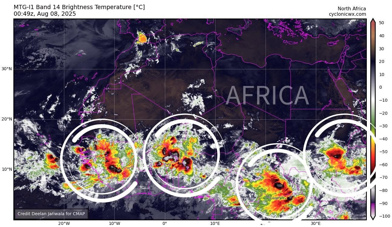
We've seen few changes in the overall expectation that the current three systems highlighted in the Atlantic are unlikely to be threats to land.
Disturbance off the Carolinas
Good news overall. The system off the Carolina coast has not shown any further signs of development, and it appears that its best chance to do so will be on exit from the East Coast as it generally follows Dexter's path out to sea.
There's just not much doing off the coast of the Carolinas. (Weathernerds.org)
Development odds have been reduced to 30 percent here as the system exits stage right. At this point there is no sign that this will impact land as it moves away. It could meander a little for a couple days south of Atlantic Canada but it currently looks to be far enough away to avoid any impacts.
Invest 96L in the deep Atlantic
Invest 96L has a few thunderstorms but little organization whatsoever. (Weathernerds.org)
The Atlantic wave got tagged as Invest 96L today, so now we can see some additional forecast data on this in the coming days. Currently, there's not much to this. But models do indicate that in the coming days, we will see some development. It's expected to continue to move somewhere between west-northwest and due northwest, which should keep it well north of the Caribbean islands. From there, it still seems likely to find the escape route north and northeast out to sea. Odds of development are 60 percent but odds of land impacts are close to zero at this time.
Tropical Storm Dexter clinging to life
Dexter will likely turn extratropical by this afternoon as it races out to sea. The transition to extratropical just means that it's no longer deriving its energy from the warmer water and tropical processes. Rather, it's now behaving more like a nor'easter and being driven by other meteorological processes, acquiring fronts, etc. In the case of Dexter, it is likely to become a hurricane-force non-tropical low pressure, or essentially a major cyclone over the open ocean that isn't a tropical system. Hazardous for shipping, may produce some rough seas off Newfoundland but nothing more than that.
Dexter is showing signs of a cold front trailing on the south side of the storm, a tell-tale signal that a tropical system is beginning to transition into an extratropical one. (Tropical Tidbits)
Dexter should eventually end up absorbed into a system or two approaching Europe next week, unlikely to produce any major impacts there.
Like responsible and thorough analysis on weather and the tropics? The Eyewall is supported by you. Consider becoming a free or paid subscriber.
Speculating on the Atlantic's future
We're starting to notice the "churn" in comments, posts, questions, etc. that usually begins to happen in August. Much of it focuses on what this model or that model did during a specific run. Yesterday's fun and games came courtesy of the evening GFS operational model, as it often does (earning it the nickname the "happy hour run"), which decided that one storm wasn't enough, so it would plant two of them on either side of Florida on day 16. Look, you do you in terms of looking at weather data, but the GFS operational beyond day 10 is virtually useless. So, I'm going to pretend that never happened.
However...
There is good reason to think that we could have something a little more interesting by the time we get to the late forecast period. This would be more in the August 20th-ish timeframe. You can see this by looking at the European model ensemble spaghetti plot. Again, these aren't answer keys, but rather they're showing you what each of the 51 ensemble members is doing with a specific system. Each ensemble member is tweaked just a little to create the real uncertainty that exists in the atmosphere at any given moment due to observational capabilities and thus each ensemble member produces a unique outcome. Within that "noise," occasionally you can derive a signal to push your confidence one way or another.
Of the European ensemble's 51 members about 60 percent show a developing system in the main development region next week but have absolutely no agreement on exactly where this occurs. (Weathernerds.org)
In this case, we have a strong signal showing up for a system, but its track representation and intensity representation lives in a sea of noise. So what we can say with authority today is that conditions may be favorable for this tropical wave emerging off Africa in a couple days to perhaps become a development candidate somewhere in the Atlantic or Caribbean about 6 to 10 days from now. In fact, yesterday's European weekly tropical cyclone anomaly chart does show slightly above normal chances for a system in the southwest Atlantic in week 2 (Aug 18-25).
Slightly above normal odds of a tropical system exist in the southwest Atlantic around the August 20th-ish timeframe. (ECMWF)
All this says is that there's a slightly better chance than usual that a system could end up somewhere in the southwest Atlantic. We can corroborate this with the traditional model ensembles, as both the Euro and GFS ensembles show at least some noise in this general area. There also seems to be some AI model agreement on this as well.
All we can say definitively today is that the next wave emerging off Africa is creating some noise in model runs that make it an area we'll probably be watching for several days. We have no idea where it's heading or what shape it will be in when it gets there, and it doesn't make sense to even begin to speculate on that topic. What we can do is remind folks that it's the ramp up to peak hurricane season now, and with quiet conditions this weekend, perhaps it's a good time to review your kits, checklists, etc. and ensure you are prepared in case this is the year for you. We'll let you know what we know when we know it.
Lowest flooding risk in weeks
Today is the first day since June 21st that the Weather Prediction Center's excessive rainfall outlook has not had a level 2 (slight) or higher risk. 46 straight days of slight risks or worse. If it's not a record, it's close.
(Iowa State Environmental Mesonet)
We will have much more to say about flooding and risks and all that eventually. I wrote a bit about flash flood warnings on my personal Substack yesterday. But I hope the folks at the Weather Prediction Center can catch their breath for a couple days now. Remarkable summer.
Tropical Discussion 2025
-
tireman4

- Global Moderator

- Posts: 7123
- Joined: Wed Feb 03, 2010 9:24 pm
- Location: Humble, Texas
- Contact:
- Attachments
-
- Screenshot 2025-08-07 083722.jpg (85.63 KiB) Viewed 27325 times
-
- Screenshot 2025-08-07 083744.jpg (90.21 KiB) Viewed 27325 times
-
- Screenshot 2025-08-07 083805.jpg (81.14 KiB) Viewed 27325 times
-
- Screenshot 2025-08-07 083824.jpg (110.65 KiB) Viewed 27325 times
-
- Screenshot 2025-08-07 083841.jpg (58.61 KiB) Viewed 27325 times
-
- Screenshot 2025-08-07 083903.jpg (85.02 KiB) Viewed 27325 times
-
DoctorMu

- Posts: 8016
- Joined: Sun Jun 28, 2015 11:58 am
- Location: College Station
- Contact:
Buckle up. Things won't be quiet for that much longer.
https://www.nhc.noaa.gov/gtwo.php?basin=atlc&fdays=2
ZCZC MIATWOAT ALL
TTAA00 KNHC DDHHMM
Tropical Weather Outlook
NWS National Hurricane Center Miami FL
800 PM EDT Thu Aug 7 2025
For the North Atlantic...Caribbean Sea and the Gulf of America:
1. Off the Southeastern United States:
A non-tropical area of low pressure is expected to form in a day or
so a few hundred miles offshore of North Carolina. Some tropical or
subtropical development is possible this weekend while the system
moves northeastward over the warm waters of the Gulf Stream. By
early next week, the low is expected to reach colder water and an
area of strong upper-level winds, ending its chances for tropical or
subtropical development.
* Formation chance through 48 hours...low...10 percent.
* Formation chance through 7 days...low...20 percent.
2. Central Atlantic (AL96):
A tropical wave over the central tropical Atlantic continues to
produce disorganized shower activity. Development of this
system appears unlikely during the next day or two, but
environmental conditions are forecast to become more conducive in a
few days. A tropical depression could form late this weekend or
early next week while the system moves west-northwestward to
northwestward across the central tropical and subtropical Atlantic.
* Formation chance through 48 hours...low...10 percent.
* Formation chance through 7 days...medium...60 percent.
- Attachments
-
- cdas-sflux_sst_global_1.png
- (94.5 KiB) Downloaded 6031 times
-
- OHC-PNG_NATL_20250807.png (250.1 KiB) Viewed 27253 times
-
Rip76

- Posts: 2126
- Joined: Mon Feb 15, 2010 12:38 am
- Location: The Woodlands
- Contact:
-
Pas_Bon
- Posts: 948
- Joined: Tue Sep 11, 2018 7:58 am
- Location: League City, TX
- Contact:
-
DoctorMu
- Posts: 8016
- Joined: Sun Jun 28, 2015 11:58 am
- Location: College Station
- Contact:
- Attachments
-
- ec-aifs_mslp_pcpn_us_54.png
- (175.29 KiB) Downloaded 5849 times
-
tireman4
- Global Moderator
- Posts: 7123
- Joined: Wed Feb 03, 2010 9:24 pm
- Location: Humble, Texas
- Contact:
The Eyewall
Matt Lanza
In brief: Invest 96L is not a concern for land. The wave behind does bear watching for much of the Atlantic basin, and today's post walks through the process over the next 5 to 7 days. Back on land, more serious flooding risks are in the cards today for Iowa and Wisconsin in particular.
Happy Saturday! Let's get you caught up on all things tropics and flooding.
Invest 96L
It's been an interesting ride for Invest 96L. Once the darling of some weather models in the open Atlantic, support for development of this one has floundered for now.
Invest 96L has thunderstorms but little to no organization right now. (Tropical Tidbits)
Over the next few days, 96L is going to turn northwest or northward into the open Atlantic. More than likely, it will head out to sea, though a couple models do kind of keep some fingerprint of the system hanging around in the central Atlantic for a bit. Either way, this one is not a concern for land, and it is unlikely to really develop much, if at all.
Next tropical wave
The National Hurricane Center added an area of interest yesterday for the tropical wave that is emerging off Africa this weekend. No development is expected initially, but by next week, development is becoming increasingly likely.
40% odds of development are noted from the tropical wave emerging off Africa, a percentage that will probably further increase this weekend. (NOAA NHC)
Many of you have been monitoring the progress of this one since earlier this week, as modeling has been periodically going ballistic with development once in the western Atlantic. Let's focus on what we can actually realistically discuss first, then we can talk about what comes next.
First, the wave emerging off Africa has what you'd want to see from a tropical wave that may develop. It's got thunderstorm activity. There's a whiff of "spin" evident. Modeling shows a good deal of mid-level vorticity as it is emerging. Basically, it's the initial seeds you'd want to see for a development candidate.
The suspect area emerging in the Atlantic on Saturday morning. (Weathernerds.org)
Over the next 2 to 3 days, the wave will continue to march west, eventually passing the Cabo Verde Islands (which may see some hefty rainfall) and settling just west of there. Interestingly, this wave is emerging around 9 to 10 degrees North latitude, but it probably won't establish itself before curling a little to the north, up around 15 degrees or so North. This is somewhat important information for the rest of the system's life, as where it establishes latitudinally could play a role in ultimately where it goes. For example, in the western Gulf, it would be exceptionally rare for a Cabo Verde storm establishing north of about 13°N to make it there. Ike was the one exception to that rule in 2008, so it serves as a reminder that rules are made to be broken, but the odds would not favor that part of the world if this is indeed where this wave establishes.
By Monday evening, we should expect to see at least a tropical wave setup north of 15°N, with only slight chances it has formed into a depression yet.
The next tropical wave will establish west of the Cabo Verde Islands by Monday evening. (Weathernerds.org)
Heading out to day 5, we still don't see a ton of development with this one, but we see a pretty strong signal over the central Atlantic, east northeast of the Lesser Antilles.
Various ensemble members from the European model and AI models show pretty good overall agreement in a general location east northeast of the Lesser Antilles by Wednesday evening. (Google Weather Lab)
There are still a number of differences in placement, speed, etc. that we can't quite resolve yet, but the general trend is pretty much in okay agreement through day 5. From this point, let's look at the upper pattern.
The overall setup of the upper pattern that may steer the disturbance around midweek next week. (Tropical Tidbits)
Initially, the disturbance will be steered around the base of high pressure east of Bermuda. This should allow it to turn more west-northwest or northwest even by mid to late next week. However, high pressure over Florida may flex later next week, which could jam up the disturbance just northeast of the Leeward Islands and Virgin Islands. Particularly if this remains fairly weak through late week, this would be the case.
From this point, it becomes a little more difficult to project where the disturbance goes. High pressure may retreat into the western Gulf by next weekend, which may open the exit door back up, allowing the system to head out to sea. Or if it holds a little firmer and longer, we could see the system get closer to the Bahamas or Florida. Or perhaps it turns north and threatens Bermuda. Or it could drift closer to the East Coast. There are many, many possibilities beyond day 5-7 right now. European ensemble member solutions range from something near Hispaniola or the Bahamas to something already halfway to Europe out to sea. There are just a ton of options out there.
So, what can we say right now? We expect a disturbance to pass the Cabo Verde Islands by Monday. From there, it will come west across the Atlantic, settling about 1,000 miles east of the Leeward Islands by Wednesday. Limited development is expected through Wednesday. From that point, the upper pattern suggests a slower movement that may adjust the disturbance some. Beyond day 7, the forecast turns sharply chaotic with numerous possibilities, intensities, locations, and tracks. Folks from the Caribbean up the East Coast and out to Bermuda should continue to monitor the progress of this tropical wave over the coming days.
Iowa and Wisconsin flooding risks
Hey, remember when I said we finally broke the streak of days without a "slight" risk of excessive rain and flooding earlier this week? Yeah, that was incorrect. A slight risk (2/4) was issued later that day. So the streak continues. And today, it's a moderate risk (3/4).
A moderate risk (3/4) exists for flooding in much of eastern Iowa into southwest Wisconsin today. (NOAA WPC)
Heavy rainfall is moving eastward this morning across Wisconsin, as well as northern Iowa. Additional heavy rain is falling in southern Iowa.
Heavy rainfall is already underway in the Upper Midwest. (College of DuPage)
As the day progresses, heavy rain will march east, new heavy rain will follow, and rain amounts of 3 to 5 inches and locally higher amounts are possible across eastern Iowa and southwest Wisconsin.
(NWS Quad Cities)
Some parts of Iowa have seen 3 to 6 inches or more over the last 2 weeks, so the ground is already primed for flooding here, especially in southeast Iowa. Folks in that region should use caution today and tonight.
- Attachments
-
- Screenshot 2025-08-09 095018.jpg (87.8 KiB) Viewed 27024 times
-
- Screenshot 2025-08-09 095046.jpg (110.07 KiB) Viewed 27024 times
-
- Screenshot 2025-08-09 095106.jpg (66.85 KiB) Viewed 27024 times
-
- Screenshot 2025-08-09 095124.jpg (47.24 KiB) Viewed 27024 times
-
- Screenshot 2025-08-09 095143.jpg (116.27 KiB) Viewed 27024 times
-
- Screenshot 2025-08-09 095219.jpg (97.54 KiB) Viewed 27024 times
-
- Screenshot 2025-08-09 095239.jpg (84.59 KiB) Viewed 27024 times
-
DoctorMu
- Posts: 8016
- Joined: Sun Jun 28, 2015 11:58 am
- Location: College Station
- Contact:
ZCZC MIATWOAT ALL
TTAA00 KNHC DDHHMM
Tropical Weather Outlook
NWS National Hurricane Center Miami FL
200 PM EDT Sat Aug 9 2025
For the North Atlantic...Caribbean Sea and the Gulf of America:
1. Eastern Tropical Atlantic (AL97):
A broad area of low pressure, associated with a tropical wave, is
producing a large area of disorganized showers and thunderstorms
just off the west coast of Africa. Environmental conditions appear
conducive for gradual development of this system, and a tropical
depression could form by the middle to latter portion of next week
while moving west-northwestward at 15 to 20 mph across the eastern
and central tropical Atlantic. Locally heavy rainfall is possible
Sunday and Monday across portions of the Cabo Verde Islands.
* Formation chance through 48 hours...low...10 percent.
* Formation chance through 7 days...medium...50 percent.
2. Central Atlantic (AL96):
Disorganized showers and thunderstorms are occurring in association
with a tropical wave over the central tropical Atlantic.
Development of this system appears unlikely during the next day or
two due to surrounding dry air, but some gradual development is
possible during the middle part of next week while the system moves
northward across the central Atlantic.
* Formation chance through 48 hours...low...near 0 percent.
* Formation chance through 7 days...low...20 percent.
- Attachments
-
- two_atl_7d0.png (174.75 KiB) Viewed 26970 times
-
tireman4
- Global Moderator
- Posts: 7123
- Joined: Wed Feb 03, 2010 9:24 pm
- Location: Humble, Texas
- Contact:
Colin Myers
- Attachments
-
- FB_IMG_1754877226833.jpg
- (208.98 KiB) Downloaded 5595 times
-
tireman4
- Global Moderator
- Posts: 7123
- Joined: Wed Feb 03, 2010 9:24 pm
- Location: Humble, Texas
- Contact:
The Eyewall
Matt Lanza
In brief: Invest 97L should become a tropical depression soon. While there is still plenty of uncertainty in the future, odds still currently favor a system heading out to sea ultimately. We explain more below. The rest of the tropics are ho hum for now. Strong heat in the West will gradually migrate back eastward this week, and we have details on that too.
Invest 97L on the cusp of developing
Our tropical disturbance in the eastern Atlantic is looking relatively healthy this morning, and it's sitting just north of 15°N latitude. Development odds are up to 90 percent, and it's entirely possible that we have a tropical depression here before this evening.
Invest 97L may be on the fringe of becoming a depression soon. (Weathernerds.org)
In a bit of an odd twist, weather modeling is actually in really, really good agreement on the general track of Invest 97L over the next 48 to 72 hours. Often in these nascent systems, there is uncertainty around exact location and placement and to some extent track. But in this case, the modeling all seems to be sniffing from the same bowl of food. In fact, you can see that European ensemble and experimental/operational AI ensemble members are all mostly packed together by Wednesday evening east of the islands.
Strong model agreement through 60 to 72 hours. (Google Weather Lab)
From there, the system will continue to track west or west-northwest across the basin arriving probably just northeast of the Leeward and Virgin Islands by late Friday or Saturday. A couple things have sort of changed since yesterday when looking at the upper-level weather pattern around whatever 97L is by Saturday or Sunday.
First, the weakness between high pressure over the Gulf and high pressure over Africa seems to have strengthened a little. This should allow 97L, likely a named storm by the weekend to gain more latitude just northeast of the islands. Historically, most storms end up tracking out to sea from there, perhaps threatening Bermuda on the way. And in this case, that's still probably the likeliest outcome. However, there is still enough uncertainty around exactly how features orient and what intensity the storm itself has at that point that does keep the Bahamas, East Coast, and Atlantic Canada still in play here.
Invest 97L is likely a tropical storm or stronger this weekend. History suggests it will head out to sea, but there remains enough uncertainty on specifics for others to continue to monitor. (Tropical Tidbits)
But, I will say that at this time at least, the vast majority of ensemble model guidance from both AI and traditional modeling is sweeping this thing out to sea. As always, we will continue to watch and keep you posted on any changes, updates, etc.
Behind Invest 97L
There's not a whole heck of a lot doing with any specificity right now behind 97L. There is another wave trailing it that may have some chance to develop a little farther south than 97L, but at this time, the AI modeling is most excited by this rather than the traditional ensembles. Some of the newer AI ensemble modeling has proven to be quite overzealous with tropical genesis this season, meaning anytime there's a remote chance of development, they jump on it too quickly. For now, we'll see if that next wave does anything, but there are no other urgent or specific concerns we've got heading through early next week at this time.
West Coast sizzle will migrate east this week
Ongoing heat in the Western U.S. continues. Portland had their hottest day since last summer yesterday, topping out at 99°, and today should be even a bit hotter.
(NWS Portland)
To the south, Las Vegas hit 110° yesterday, their 3rd hottest of this summer. They'll come close to their hottest of summer today and tomorrow as well, with highs of 109-111° expected, near records for this time of year. Expect strong heat relative to normal today in Michigan and northern Maine as well. Heading through the week, the focus of heat will gradually shift back toward Florida and the Southeast.
Thursday's heat risk peaks over Florida with near extreme heat between Tampa and Orlando. (NOAA)
Remember the high pressure system that sort of closes off the Gulf from Invest 97L? Well, it should keep the Gulf out of play from a tropical system, but it'll definitely make you sweat!
- Attachments
-
- Screenshot 2025-08-11 074227.jpg (102.05 KiB) Viewed 26754 times
-
- Screenshot 2025-08-11 074259.jpg (40.52 KiB) Viewed 26754 times
-
- Screenshot 2025-08-11 074324.jpg (118.42 KiB) Viewed 26754 times
-
- Screenshot 2025-08-11 074343.jpg (76.87 KiB) Viewed 26754 times
-
- Screenshot 2025-08-11 074410.jpg (62.83 KiB) Viewed 26754 times
-
Cpv17
- Posts: 7091
- Joined: Fri Aug 31, 2018 1:58 pm
- Location: El Campo/Wharton
- Contact:
-
Stratton20
- Posts: 5814
- Joined: Tue Feb 09, 2021 11:35 pm
- Location: College Station, Texas
- Contact:
Cpv17 Euro has another system behind Erin, that kelvin wave should help these next couple of waves to hold together more
-
Cpv17
- Posts: 7091
- Joined: Fri Aug 31, 2018 1:58 pm
- Location: El Campo/Wharton
- Contact:
I noticed that, but it doesn’t have much ensemble support at all. In fact, ensembles are relatively quiet for the next couple weeks.Stratton20 wrote: ↑Mon Aug 11, 2025 3:14 pm Cpv17 Euro has another system behind Erin, that kelvin wave should help these next couple of waves to hold together more
-
DoctorMu
- Posts: 8016
- Joined: Sun Jun 28, 2015 11:58 am
- Location: College Station
- Contact:
X marks the spot on an old boundary in the Gulf. For now, no development is expected and no projected movement - stationed off the Louisiana coast.
https://www.nhc.noaa.gov/gtwo.php?basin=atlc&fdays=5
Tropical Weather Outlook
NWS National Hurricane Center Miami FL
800 AM EDT Tue Aug 12 2025
For the North Atlantic...Caribbean Sea and the Gulf of America:
Active Systems:
The National Hurricane Center is issuing advisories on Tropical
Storm Erin, located over the eastern tropical Atlantic several
hundred miles west of the Cabo Verde Islands.
1. Northwestern Atlantic:
A non-tropical area of low pressure located a few hundred miles
southeast of Nova Scotia, Canada, is producing disorganized shower
and thunderstorm activity to the west of its center. Some
limited tropical or subtropical development is possible over the
next day or so as the low meanders near the relatively warm waters
of the Gulf Stream. The system is expected to move northward over
cooler waters by Wednesday, ending its chances for tropical
development.
* Formation chance through 48 hours...low...10 percent.
* Formation chance through 7 days...low...10 percent.
2. North-Central Gulf:
A surface trough near the coast of Louisiana is producing a broad
area of disorganized showers and thunderstorms. While development
of this system is not anticipated before it moves inland later
today, locally heavy rainfall could produce flash flooding across
portions of the northern Gulf coast over the next day or so. For
more information on the rainfall hazards related to this system,
please see products issued by your local National Weather Service
forecast office.
* Formation chance through 48 hours...low...near 0 percent.
* Formation chance through 7 days...low...near 0 percent.
Public Advisories on Tropical Storm Erin are issued under WMO header
WTNT35 KNHC and under AWIPS header MIATCPAT5. Forecast/Advisories on
Tropical Storm Erin are issued under WMO header WTNT25 KNHC and
under AWIPS header MIATCMAT5.
Forecaster Berg
- Attachments
-
- 20252241611_GOES19-ABI-ga-GEOCOLOR-1000x1000.jpg (857.45 KiB) Viewed 26498 times
-
Cpv17
- Posts: 7091
- Joined: Fri Aug 31, 2018 1:58 pm
- Location: El Campo/Wharton
- Contact:
This is a nothing burger. Watch the area in the western Caribbean to increase rain chances around here later this week.DoctorMu wrote: ↑Tue Aug 12, 2025 11:26 am X marks the spot on an old boundary in the Gulf. For now, no development is expected and no projected movement - stationed off the Louisiana coast.
https://www.nhc.noaa.gov/gtwo.php?basin=atlc&fdays=5
Tropical Weather Outlook
NWS National Hurricane Center Miami FL
800 AM EDT Tue Aug 12 2025
For the North Atlantic...Caribbean Sea and the Gulf of America:
Active Systems:
The National Hurricane Center is issuing advisories on Tropical
Storm Erin, located over the eastern tropical Atlantic several
hundred miles west of the Cabo Verde Islands.
1. Northwestern Atlantic:
A non-tropical area of low pressure located a few hundred miles
southeast of Nova Scotia, Canada, is producing disorganized shower
and thunderstorm activity to the west of its center. Some
limited tropical or subtropical development is possible over the
next day or so as the low meanders near the relatively warm waters
of the Gulf Stream. The system is expected to move northward over
cooler waters by Wednesday, ending its chances for tropical
development.
* Formation chance through 48 hours...low...10 percent.
* Formation chance through 7 days...low...10 percent.
2. North-Central Gulf:
A surface trough near the coast of Louisiana is producing a broad
area of disorganized showers and thunderstorms. While development
of this system is not anticipated before it moves inland later
today, locally heavy rainfall could produce flash flooding across
portions of the northern Gulf coast over the next day or so. For
more information on the rainfall hazards related to this system,
please see products issued by your local National Weather Service
forecast office.
* Formation chance through 48 hours...low...near 0 percent.
* Formation chance through 7 days...low...near 0 percent.
Public Advisories on Tropical Storm Erin are issued under WMO header
WTNT35 KNHC and under AWIPS header MIATCPAT5. Forecast/Advisories on
Tropical Storm Erin are issued under WMO header WTNT25 KNHC and
under AWIPS header MIATCMAT5.
Forecaster Berg
-
Stratton20
- Posts: 5814
- Joined: Tue Feb 09, 2021 11:35 pm
- Location: College Station, Texas
- Contact:
African Wave train season is just getting started
- Attachments
-
- IMG_3741.png
- (260.99 KiB) Downloaded 5237 times
-
Cpv17
- Posts: 7091
- Joined: Fri Aug 31, 2018 1:58 pm
- Location: El Campo/Wharton
- Contact:
The season of the recurve.
-
Stratton20
- Posts: 5814
- Joined: Tue Feb 09, 2021 11:35 pm
- Location: College Station, Texas
- Contact:
Cpv17 I dont know about that just because the zones look like a recurve lol
-
Cpv17
- Posts: 7091
- Joined: Fri Aug 31, 2018 1:58 pm
- Location: El Campo/Wharton
- Contact:
20% chance given to the wave in the western Caribbean by the NHC.
-
Stratton20
- Posts: 5814
- Joined: Tue Feb 09, 2021 11:35 pm
- Location: College Station, Texas
- Contact:
Yup, should at least get a surge of tropical moisture from it
-
Ptarmigan

- Statistical Specialist

- Posts: 4519
- Joined: Wed Feb 03, 2010 7:20 pm
- Contact:
The tropics are sure picking up for sure.