
103
FXUS64 KHGX 071103
AFDHGX
Area Forecast Discussion
National Weather Service Houston/Galveston TX
603 AM CDT Mon Jul 7 2025
...New AVIATION...
.KEY MESSAGES...
Issued at 1218 AM CDT Mon Jul 7 2025
- Expect daily development of showers and thunderstorms through
the end of the week, peaking in the afternoons.
- Locally heavy downpours are the primary concern from the
strongest of these daily rounds of storms.
- We may see a shift in the pattern towards a hotter and drier
setup late in the week, but the precise timing of this shift is
quite uncertain.
&&
.DISCUSSION...
Issued at 1218 AM CDT Mon Jul 7 2025
We are solidly in a summer weather pattern across Southeast Texas,
and the forecast will continue to revolve around the daily nuances
in passing features modulating the strength and orientation of the
subtropical ridge. The main feature of interest for us this week
will be an inverted trough making its way across the Gulf in our
direction, then gradually settling in over eastern Texas for a bit
before drifting southwest towards the Rio Grande late in the week.
Rain chances will be on the rebound as the trough makes its way
in, with greater afternoon coverage of showers and storms. This
trend should peak in the middle of the week when the trough is
more or less over us, and also looks to maybe link up a bit with
troughiness in the northern stream. This will keep midlevel
heights suppressed, and more supportive of more widespread diurnal
convection. Fortunately, precipitable water looks to be below the
90th percentile, which should preclude a watchout for flooding
issues...but PWATs in the area during summer are high enough
typically where isolated spots of concern may emerge should the
strongest storms of the day drop some localized downpours on a
particularly vulnerable spot.
Later in the week, though the daily potential for summertime
convection will continue, we should see coverage diminish
gradually as the trough drifts off to the southwest and ridging at
least attempts to build back in. However, it looks like the
highest heights will be way out over the Desert Southwest, while
we kind of struggle to fill in the weakness in the subtropical
ridge the passing trough leaves behind. Because of this, I`m not
ready to dry things out entirely, just start to trend PoPs
downward into the end of the week.
As these seasonable daily rain trends carry on, so too do
seasonable temperatures. We should see things fairly close to
seasonal averages for much of the week thanks to the afternoon
clouds and rainfall keeping things from getting too out of hand.
Indeed, my main alteration to the NBM was to replace the
deterministic highs with the 50th percentile of the NBM (and
tweaked slightly with other consensus blends) to hedge on the
slightly cooler side of things. Late in the week, we should see
temperatures start to slowly make their way upwards, and I do
allow that to occur, but until I see a real solid return of the
subtropical ridge, I don`t think I`m quite ready to commit fully
to a meaningfully hotter/drier pattern. It should happen at some
point...I`m just not confident in precisely when, just yet.
&&
.AVIATION...
(12Z TAF Issuance)
Issued at 557 AM CDT Mon Jul 7 2025
Low but non-zero chance of MVFR conditions during the early
morning hours. Scattered showers and isolated storms will be
possible across the region during the daytime, especially in the
afternoon. Light southerly winds and VFR conditions will prevail
throughout much of the TAF period.
03
&&
.MARINE...
Issued at 1218 AM CDT Mon Jul 7 2025
Daily shower and thunderstorm chances continue through the end of
the week. Light to moderate winds and low seas are expected
through Wednesday. Occasionally higher gusts up to 15 to 20 knots
are possible, particularly later in the week. Winds and seas may
increase towards the end of the week along with the increase in
winds. Locally higher winds and seas possible in the vicinity of
any thunderstorm that develops over the bays and Gulf waters this
week.
At the coast, the generally onshore winds will boost water levels
above astronomical norms, and guidance suggests several high tides
with levels above 2.5 feet above MLLW - more similar to highest
astronomical tides, when those would generally be above a foot
lower, near MHHW. Still, this is pretty safely below any coastal
flooding concerns. Similarly, while risk for rip currents is not
low because of the persistent onshore winds, rip current risk (and
observed strength per Galveston Beach Patrol) looks to be more
moderate for the time being.
&&
.PRELIMINARY POINT TEMPS/POPS...
College Station (CLL) 90 74 91 73 / 30 10 30 10
Houston (IAH) 92 77 92 75 / 50 10 50 10
Galveston (GLS) 90 82 90 82 / 40 10 30 20
&&
.HGX WATCHES/WARNINGS/ADVISORIES...
TX...None.
GM...None.
&&
$$
DISCUSSION...Luchs
AVIATION...03
MARINE...Luchs
July 2025
-
tireman4

- Global Moderator

- Posts: 7161
- Joined: Wed Feb 03, 2010 9:24 pm
- Location: Humble, Texas
- Contact:
-
Cpv17
- Posts: 7109
- Joined: Fri Aug 31, 2018 1:58 pm
- Location: El Campo/Wharton
- Contact:
More flooding taking place across CTX this morning. The Copperas Cove area is absolutely getting hammered this morning.
-
tireman4
- Global Moderator
- Posts: 7161
- Joined: Wed Feb 03, 2010 9:24 pm
- Location: Humble, Texas
- Contact:
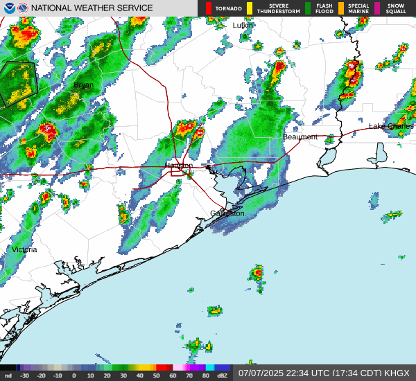
That warm core is at it again. At least on the front part of the week, there is nothing to dislodge it.
- Attachments
-
- Screenshot 2025-07-07 090341.jpg
- (210.3 KiB) Downloaded 1351 times
-
tireman4
- Global Moderator
- Posts: 7161
- Joined: Wed Feb 03, 2010 9:24 pm
- Location: Humble, Texas
- Contact:
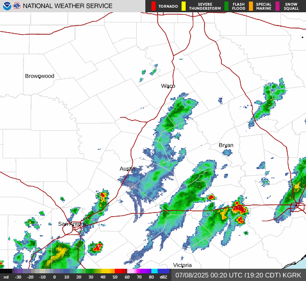
and it continues...
- Attachments
-
- Screenshot 2025-07-07 102417.jpg
- (290.02 KiB) Downloaded 1315 times
-
biggerbyte
- Posts: 1441
- Joined: Thu Feb 04, 2010 12:15 am
- Location: Porter, Texas. (Montgomery County)
- Contact:
So many innocent lives gone. It is something I'll never understand.
-
tireman4
- Global Moderator
- Posts: 7161
- Joined: Wed Feb 03, 2010 9:24 pm
- Location: Humble, Texas
- Contact:
Not sure where to put this, so I will stick it here....
The Eyewall
Chantal floods North Carolina further underscoring the need to monitor forecast adjustments ahead of events
By Matt Lanza on July 7, 2025
In brief: Tropical Storm Chantal's remnants brought record flooding to parts of North Carolina overnight. It will exit off to the north and east later today. More heavy rain is causing flooding issues in Texas again. And Saharan dust is choking the Atlantic for now. For those that rely on email subscriptions to the site, please see the bottom for changes taking shape today.
Note: Most of the data in these posts originates from NOAA and NWS. Many of the taxpayer-funded forecasting tools described below come from NOAA-led research from research institutes that will have their funding eliminated in the current proposed 2026 budget. Access to these tools to inform and protect lives and property would not be possible without NOAA’s work and continuous research efforts.
North Carolina Chantal flooding
Overnight, rains pounded portions of North Carolina and southern Virginia.
Rain totals ending this morning from the last 48 hours show as much as 7 to 10 inches parts of interior North Carolina between the Triangle and Triad. (NOAA NSSL)
The Eno and Haw Rivers in North Carolina are in record flooding territory as a result of the rains. The Haw River's records go back to the 1970s and the record level of about 22.5 feet was set earlier this morning southwest of Durham near Bynum, NC.
A preliminary record flood on the Haw River southwest of Durham. (NOAA)
The Eno River just northwest of Durham absolutely obliterated the previous record by nearly 10 feet. Records appear to only go back to the 1980s, but there's no questioning that this was a very impressive new record.
The Eno River broke its previous flood of record by nearly 10 feet outside Durham, NC. (NOAA)
This was another instance where people were left scrambling in the middle of the night to get to higher ground. And it's another instance where warnings may have been meteorologically adequate but receiving them was tougher. This topic is going to justifiably take up a lot of oxygen in the coming days.
Much like the flooding in Texas, this flooding in North Carolina while somewhat predictable escalated very late in the game forecast-wise. Compare the 48 hour rainfall forecasts using the probability matched mean product from NOAA's HREF model below. The 00z run, what I was looking at yesterday while writing my post showed minimal risk of significant flooding rains. The 12z run, which was available a couple hours later? Much more adequate.
NOAA's HREF model caught onto the rains late in the game but once it did, it did a very good job. (NOAA SPC)
The HRRR model also caught on late in the game too, though its performance actually worsened somewhat as the day progressed.
I think that the takeaway here is we had another event that showed us how model guidance in flash flood situations needs to be monitored religiously leading up to the event. If you are an end user of weather forecast information in Texas or North Carolina and you assumed the forecast was settled by 9 AM on the day of the nighttime event that caused historic flooding, you missed out on a ton of critically valuable information. Weather forecasting is so much better in 2025 than it ever has been. Our tools rarely miss something major at the end of the day. But they don't always catch on 2 or 3 days ahead of time. But if you happen to use weather information to conduct your work or business or for public safety, it is absolutely critical that you monitor things closely leading up to any weather event. We can't just assume anymore that it will be all's well that ends well. And we can't just check out on any given day.
Texas flooding continues
Another round of heavy rain impacted portions of Texas overnight, with upwards of 4 to 8 inches of rain falling in some small areas west of Killeen, farther north than the weekend's rainfall.
Rainfall estimates for the last 24 hours ending this morning. (NOAA NSSL)
No major incidents have been reported yet, but flooding did occur in the Killeen area.
Rains are expected to continue through the day in spots. The overall weather pattern responsible for a lot of the rain and flooding is beginning to slowly unwind though, so as the week progresses, storminess should begin to ease up some.
Moderate risk (level 3/4) of flash flooding exists north and west of Kerrville in much of Hill Country today. (NOAA WPC)
Still the moderate risk for excessive rainfall is in place, as we still have some ingredients available for hefty rainfall. It is possible that heavy rains will disrupt recovery efforts, and all people in the region responding to Thursday night's disaster should remain on guard for heavy rainfall and quickly changing conditions today.
Tropical Atlantic
Quiet in the Atlantic, with Chantal's remnants continuing to lift northward up the Eastern Seaboard. Those will exit off the coast of New Jersey today and out to sea. Locally heavy downpours could occur in spots from the Chesapeake Bay into the Philadelphia and Trenton areas. A slight risk (2/4) for heavy rainfall exists there.
Forecast rain totals in excess of 4 inches are possible in Delmarva today through Wednesday from Chantal's remnants and a humid, warm weather pattern. (Pivotal Weather)
Beyond Chantal I think the Atlantic looks quiet this week. We have a lot of Saharan dust in place, and that should help suppress any development. After this week, the next area to watch may be in the northeastern Gulf of Mexico next week. A handful of ensemble members and AI ensemble members from various model suites indicate some potential there in about 10 days or so. Nothing to worry about at this time.
Saharan dust is choking most of the Atlantic basin right now, which should help limit any tropical concerns over the next 7 to 10 days there. (University of Wisconsin Cooperative Institute for Meteorological Satellite Studies)
Last note, our housekeeping update:
We will be migrating our email newsletter over to the Substack platform today. If you currently subscribe to The Eyewall via email, your email should roll over to our Substack without you having to do anything. We understand a few people have various concerns about the Substack platform, and some of the content posted there by other writers. If you decide to unsubscribe from emails, we understand. But the benefits of this route outweigh the potential costs. The primary issue is that WordPress caps our email subscribers, and the process to manage an account is not user-friendly. For a site with a limited budget such as ours, this is the best way to ensure the continued delivery of an email newsletter with our content. We will still continue to post here at The Eyewall.com, but updates will not be sent via email from here.
Also: Nothing at all is changing with Space City Weather. So for our Houston readers, our site, email, and annual fundraiser is not changing! This only applies to The Eyewall.
We hope that this will offer us the flexibility to do more things, offer more options, more content, and a better overall user experience as time goes on. Thanks for your support!
- Attachments
-
- Screenshot 2025-07-07 120225.jpg (113.97 KiB) Viewed 2751 times
-
- Screenshot 2025-07-07 120248.jpg (104.16 KiB) Viewed 2751 times
-
- Screenshot 2025-07-07 120305.jpg (106.71 KiB) Viewed 2751 times
-
- Screenshot 2025-07-07 120327.jpg (179.75 KiB) Viewed 2751 times
-
- Screenshot 2025-07-07 120347.jpg (182.1 KiB) Viewed 2751 times
-
- Screenshot 2025-07-07 120407.jpg (121.58 KiB) Viewed 2751 times
-
- Screenshot 2025-07-07 120433.jpg (86.71 KiB) Viewed 2751 times
-
- Screenshot 2025-07-07 120451.jpg (125.2 KiB) Viewed 2751 times
-
- Screenshot 2025-07-07 120510.jpg (121.73 KiB) Viewed 2751 times
-
tireman4
- Global Moderator
- Posts: 7161
- Joined: Wed Feb 03, 2010 9:24 pm
- Location: Humble, Texas
- Contact:
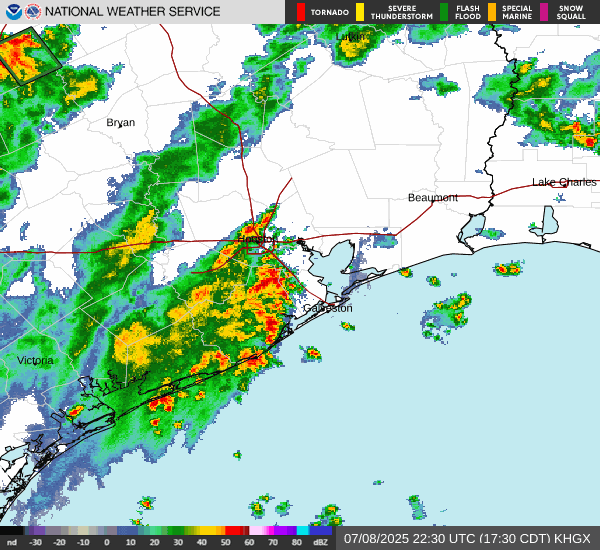
The 12:45 Radar
- Attachments
-
- Screenshot 2025-07-07 124310.jpg (129.19 KiB) Viewed 2735 times
-
tireman4
- Global Moderator
- Posts: 7161
- Joined: Wed Feb 03, 2010 9:24 pm
- Location: Humble, Texas
- Contact:
854
FXUS64 KHGX 071647
AFDHGX
Area Forecast Discussion
National Weather Service Houston/Galveston TX
1147 AM CDT Mon Jul 7 2025
...New MARINE...
.KEY MESSAGES...
Issued at 1136 AM CDT Mon Jul 7 2025
- A daily risk of showers and thunderstorms continues through the
end of the week. Not every location will receive rain every day.
- Locally heavy thunderstorms capable of localized flooding
cannot be ruled out.
- Seasonably hot and very humid conditions to prevail through the
forecast period.
&&
.DISCUSSION...
Issued at 1103 AM CDT Mon Jul 7 2025
Our region is beginning to feel the influence of a mid/upper low
that is currently in the Gulf, centered south of Louisiana. This
low will continue it`s slow westward progression over the next few
days, enhancing shower/thunderstorm chances across southeast
Texas through Wednesday. By Thursday, SE Texas may experience the
influence of another trough that builds southwestward from the
Midwest into the Arklatex. With continuously high PWATs in place,
the added lift from these mid/upper disturbance will result in
daily shower/thunderstorm chances through the end of the week. Not
every community will receive rain each day. But those that do
could experience locally heavy rainfall and localized flooding.
Ridging may try to build by the end of the week / weekend. But
long range models have consistently over estimated ridging beyond
5 or 6 days. When looking at the day-to-day forecast, you may
notice that Friday`s rain chances are the lowest of the week. This
is due to the lower PWATs indicated by the global models on that
day.
Regarding temperatures, inland afternoon highs are expected to
average in the low/mid 90s, with coastal areas generally around
90. It will remain quite humid. A few areas may achieve the upper
90s by the end of the week if ridging manages to build enough.
Generally speaking, these values are pretty normal for this time
of year. But even normal southeast Texas July heat is hazardous,
especially to sensitive groups (example: elderly and young
children) and for people doing moderate to strenuous physical
activity outside.
Self
&&
.AVIATION...
(18Z TAF Issuance)
Issued at 1103 AM CDT Mon Jul 7 2025
Scattered shra/tsra expected this afternoon. Locally heavy tsra
possible. Shra/tsra should diminish this evening. Mostly VFR
conditions through the TAF period. However, sub-VFR conditions are
likely within heavier tsra. There may also be localized areas of
MVFR cigs and vis tomorrow morning. Shra possible tomorrow morning
south of I-10, expanding farther inland by the afternoon. Tsra
will be possible again by the afternoon tomorrow.
&&
.MARINE...
Issued at 1136 AM CDT Mon Jul 7 2025
Scattered showers and thunderstorms are expected most days this
week. Winds through the middle of the week will generally be from
the south in the 10-15 knot range with occasionally gusts. Seas
should generally be 2-3 feet. However, winds and seas are expected
to increase somewhat by the end of the week. Some of the models
are showing a relatively large 15-20 knot fetch developing over
the Gulf, suggesting that the current forecast of 4 foot seas in
our offshore zones is a little low. Coudln`t rule out higher seas
if the larger fetch scenario pans out.
&&
.PRELIMINARY POINT TEMPS/POPS...
College Station (CLL) 90 74 91 73 / 50 10 40 10
Houston (IAH) 92 76 92 75 / 60 10 70 10
Galveston (GLS) 90 83 90 82 / 50 20 50 20
&&
.HGX WATCHES/WARNINGS/ADVISORIES...
TX...None.
GM...None.
&&
$$
DISCUSSION...Self
AVIATION...Self
MARINE...Self
-
DoctorMu

- Posts: 8091
- Joined: Sun Jun 28, 2015 11:58 am
- Location: College Station
- Contact:
I can't imagine all the mixed emotions grabbing your daughter. Katrina was a terrible day and week and years afterwards.Pas_Bon wrote: ↑Mon Jul 07, 2025 6:32 am This event has devastated me on a level which I cannot remember feeling since Katrina. I was stuck at a NOLA hospital during Katrina and afterwards. This caused all those memories to come flooding back. I know Harvey was horrible, too. I picked up my 11yo daughter from week-long Summer camp on Saturday morning and there are parents who never had the chance to do so. I am gutted.
-
DoctorMu
- Posts: 8091
- Joined: Sun Jun 28, 2015 11:58 am
- Location: College Station
- Contact:
-
DoctorMu
- Posts: 8091
- Joined: Sun Jun 28, 2015 11:58 am
- Location: College Station
- Contact:
More of this is likely through Wednesday at least.
-
Ptarmigan

- Statistical Specialist

- Posts: 4536
- Joined: Wed Feb 03, 2010 7:20 pm
- Contact:
So much lives loss and grief. 

Hill Country flood disaster: What we know about the victims so far
https://www.khou.com/article/news/local ... 28413edf47
Hill Country flood disaster: What we know about the victims so far
https://www.khou.com/article/news/local ... 28413edf47
-
Pas_Bon
- Posts: 968
- Joined: Tue Sep 11, 2018 7:58 am
- Location: League City, TX
- Contact:
It looks like we may get through all of June and July with very few - if any - triple digit thermometer readings. I know in League City, there have been none thus far. This Summer has been a far cry from the last couple years. Stratton, you were spot-on earlier this year.
I’d take every day being 100° +, though, if we could get back all those innocent lives that were lost.
I’d take every day being 100° +, though, if we could get back all those innocent lives that were lost.
-
Ptarmigan
- Statistical Specialist
- Posts: 4536
- Joined: Wed Feb 03, 2010 7:20 pm
- Contact:
The loss of children at Camp Mystic is beyond unthinkable. The Central Texas Flood is a national tragedy.Pas_Bon wrote: ↑Mon Jul 07, 2025 6:32 am This event has devastated me on a level which I cannot remember feeling since Katrina. I was stuck at a NOLA hospital during Katrina and afterwards. This caused all those memories to come flooding back. I know Harvey was horrible, too. I picked up my 11yo daughter from week-long Summer camp on Saturday morning and there are parents who never had the chance to do so. I am gutted.
-
Stratton20
- Posts: 5870
- Joined: Tue Feb 09, 2021 11:35 pm
- Location: College Station, Texas
- Contact:
Even into the third week of july, the GFS keeps things on the active side down around here , heck the CMC/ GFS overnight guidance both have a surprisingly strong july cold front in the 8-10 day window lol
-
Pas_Bon
- Posts: 968
- Joined: Tue Sep 11, 2018 7:58 am
- Location: League City, TX
- Contact:
Hope it snowsStratton20 wrote: ↑Tue Jul 08, 2025 12:53 am Even into the third week of july, the GFS keeps things on the active side down around here , heck the CMC/ GFS overnight guidance both have a surprisingly strong july cold front in the 8-10 day window lol
-
tireman4
- Global Moderator
- Posts: 7161
- Joined: Wed Feb 03, 2010 9:24 pm
- Location: Humble, Texas
- Contact:
875
FXUS64 KHGX 081108
AFDHGX
Area Forecast Discussion
National Weather Service Houston/Galveston TX
608 AM CDT Tue Jul 8 2025
...New AVIATION...
.KEY MESSAGES...
Issued at 1202 AM CDT Tue Jul 8 2025
- Scattered to widespread showers and thunderstorms are expected each
day through this week.
- Isolated strong thunderstorms will lead to gusty winds and localized
downpours. If more than one of these storms moves over the same
area, or happens to fall over an area of poor drainage, then
minor street flooding/ponding will be possible.
- Near seasonal temperatures will persist, but seasonal this time
of year is still hot. Make sure to take breaks if working
outside and stay hydrated.
Fowler
&&
.DISCUSSION...
Issued at 1202 AM CDT Tue Jul 8 2025
Weak troughing aloft, daytime heating, and PWATs near 2" will lead
to continued daily rain chances through at least Thursday, but
possibly beyond. What we experienced earlier today (showers and
storms popping up along the coast in the morning, then spreading
inland through the day with isolated downpours) will be the template
through the week with each day having a fairly similar set-up. Not
everyone will get rainfall every day, but where the rain falls it
could be heavy (a very realistic scenario is you have no rain
through the day, but your neighbors just a few streets over could
see an inch or two). Coverage of the showers and thunderstorms may
be less starting on Friday as the upper-level trough begins to
weaken and PWATs lower slightly, but some guidance continues the
upper-level troughing through the weekend.
Temperatures through the week will be fairly seasonal, but seasonal
in July is still quite warm. Highs will be in the low to mid 90s
inland through Wednesday, then some spots possible reaching the
upper 90s by the weekend as rain chances diminish. Overnight lows
will be in the mid to upper 70s inland, and low 80s along the coast.
Fowler
&&
.AVIATION...
(12Z TAF Issuance)
Issued at 525 AM CDT Tue Jul 8 2025
Few stray MVFR cigs early today should clear later this morning.
Scattered showers/thunderstorms will be possible throughout the
daytime, beginning along the coast early in the day with activity
shifting northward later in the afternoon/evening. Rain chances
taper off into the evening with light winds expected overnight
once again. A few stray MVFR CIGS will be possible again Wednesday
morning, mainly ares north/northwest of the city such as
KCLL/KUTS.
03
&&
.MARINE...
Issued at 1202 AM CDT Tue Jul 8 2025
It will be a bit of a rinse and repeat pattern this week with
shower and thunderstorms possible each day. Some isolated showers
will develop near daybreak over the Gulf waters, then scattered
showers and thunderstorms expanding into the Bays during the late
mornings and afternoons. Light to moderate winds and low seas are
expected through Wednesday with occasionally higher gusts up to 15
to 20 knots are possible. Winds and seas may increase towards the
end of the week.
Fowler
&&
.PRELIMINARY POINT TEMPS/POPS...
College Station (CLL) 90 73 92 75 / 40 20 40 10
Houston (IAH) 91 75 92 76 / 70 20 70 20
Galveston (GLS) 89 82 88 81 / 70 20 60 30
&&
.HGX WATCHES/WARNINGS/ADVISORIES...
TX...None.
GM...None.
&&
$$
DISCUSSION...Fowler
AVIATION...03
MARINE...Fowler
-
tireman4
- Global Moderator
- Posts: 7161
- Joined: Wed Feb 03, 2010 9:24 pm
- Location: Humble, Texas
- Contact:
Because there is a mix of tropical and national weather, I am putting it here.
In brief: The tropics remain calm, but we're watching the Gulf next week -- sort of. We have the latest on Texas flooding and some thoughts on mitigation. Also, flooding is possible in the Mid-Atlantic and New England today and/or tomorrow.
Note: Most of the data in these posts originates from NOAA and NWS. Many of the taxpayer-funded forecasting tools described below come from NOAA-led research from research institutes that will have their funding eliminated in the current proposed 2026 budget. Access to these tools to inform and protect lives and property would not be possible without NOAA’s work and continuous research efforts.
Tropical Atlantic
First off, there's nothing at all to report in the tropical Atlantic today. We look quiet for the next week or so.
I think the next area to watch will probably be in the Gulf next week. A little piece of "energy" (or mid-level vorticity...spin in the atmosphere around 10,000 feet) may pinwheel from an area of weekend thunderstorms in the Mid-Atlantic, off the Southeast coast early next week, and into the northeast Gulf midweek.
Potential area of weak "spin" in the northeast Gulf next weekend. (Tropical Tidbits)
This would not be a highly likely pathway to development, but we have absolutely seen storms do this before, most notably in recent years probably Hurricane Barry back in 2019. The seeds for that storm were actually planted in Kansas with some thunderstorms that eventually arrived in the Gulf and spun into a storm that became 2019's Barry. While Barry wasn't a particularly strong storm it was loaded with moisture and ended up being the wettest on record for Arkansas and caused widespread flooding in Louisiana and over a half-billion in damage. So they can happen.
In this case, we will have to watch how this evolves in the coming days; it's possible it ends up too close to land to develop, it ends up actually over land, it never emerges in the Gulf at all, or it ends up taking a farther south pathway to boost the odds of development. Current modeling suggests the "too close to land" scenario is most likely, but we'll see. Either way, we have a long time to watch this, and it's nothing to worry over today.
This Substack is reader-supported. To receive new posts and support our work, consider becoming a free or paid subscriber.
Upgrade to paid
Texas flooding update
A lot of news coming out of Texas with respect to the impacts, response, and recovery to the Texas flooding catastrophe. I strongly recommend following The Texas Tribune's coverage, as they know the state better than most and will have good quality information. I want to home in on one story about the Texas Senate declining to take up a bill that would have bolstered flood protection in the Hill Country and Flash Flood Alley. House Bill 13 would have provided about a half-billion dollars for numerous improvements to public safety communication, alerting, and sirens in places, similar to those that have tornado sirens. The bill was proposed by a GOP representative, Ken King from Canadian, TX, the area devastated by the Smokehouse Creek fire in 2024. There is one quote in particular that was made during the debate on this bill that I want to highlight.
Tony Tinderhort, an Arlington, TX Republican said this: “This shouldn't be about anything other than the fact that it's a half a billion dollars. This is probably one of the most simple votes we should be able to take today. It's that this interoperability council is going to spend money to try and get these departments to be able to talk together.”
It's easy to look at things in hindsight and become outraged, but importantly, I think this is a comment that speaks volumes about priorities among some legislators, not just in Texas but nationwide. First off, let's be clear, this bill would not have prevented or mitigated this catastrophe in any way. It would not have been implemented until September. Secondly, even if the build out were completed, there is no way to know if it would have saved lives. Secondly, according to a January piece, Texas had a $28 billion surplus and $24 billion in the rainy day fund coming into this year. The proposed bill would have eaten up about 1.5 percent of the budget surplus.
When thinking of disasters, the easy thing to do is to throw up your hands and say "weather happens" and "bad things happen sometimes." But time and time and time again it has been proven that preparedness and adequate ways to disseminate warnings save lives. Investing in preparedness is like investing in your health or home or whatever else you want to invest in. The phrase "an ounce of prevention is worth a pound of cure" originated from Benjamin Franklin, a relatively libertarian leaning individual that knew a thing or two about science and how the natural world works. That was almost 300 years ago. Much like Franklin's legacy, it has stood the test of time. When we have leaders constantly badgering others about investing in preparedness because of sticker shock, the question has to be, what amount of damage or loss of life has to occur for them to get on board with improving societal preparedness? That's an important question to ask representatives and ensure they're looking out for their constituents and society and its best interest. This isn't even a climate change conversation, it's an every day one. It's food for thought.
Flooding concerns this week
Much of the Mid-Atlantic is in a slight risk (2/4) for flash flooding today, with risks extending from Virginia into southern New England, including DC, Baltimore, Philly, and New York City.
A slight risk for excessive rains today extends from the Mid-Atlantic into New England. (NOAA WPC)
We should expect to see heavy thunderstorms late this afternoon and evening across the area. The combination of storms and very high atmospheric moisture levels will lead to the potential for excessive rainfall rates of 2 inches an hour. Flood watches are in effect for most of the slight risk region.
On Wednesday, the risk shifts to the south and east into mostly the Mid-Atlantic.
Wednesday's rainfall risk is also slight (2/4) from North Carolina into southern New Jersey. (NOAA WPC)
Rainfall forecast totals from the probability matched mean product of the HREF model from NOAA are on the order of 1-2 inches area-wide with isolated pockets up to 4 inches in this general region. It's in those isolated areas that flash flooding could be an issue.
HREF PMM precip forecast for the Mid-Atlantic region into southern New England showing lollipops of 2 to 4 inches in spots. (NOAA SPC)
Additional flooding risk exists in Arkansas and Missouri today, where radar is active with showers and storms already.
- Attachments
-
- Screenshot 2025-07-08 113543.jpg (148.56 KiB) Viewed 2384 times
-
- Screenshot 2025-07-08 113607.jpg (115.3 KiB) Viewed 2384 times
-
- Screenshot 2025-07-08 113631.jpg (110.68 KiB) Viewed 2384 times
-
- Screenshot 2025-07-08 113657.jpg (213.16 KiB) Viewed 2384 times
-
tireman4
- Global Moderator
- Posts: 7161
- Joined: Wed Feb 03, 2010 9:24 pm
- Location: Humble, Texas
- Contact:
Avery Tomasco
- Attachments
-
- Screenshot 2025-07-08 132626.png (367.23 KiB) Viewed 2329 times
-
DoctorMu
- Posts: 8091
- Joined: Sun Jun 28, 2015 11:58 am
- Location: College Station
- Contact:
Never, never underestimate warm core storms, especially at night. That's why old salt Mets are an incredibly invaluable resource. They've seen these systems, whether Atlantic or EPAC or Gulf, thwart the models and young buck Mets.
OK, we have the Louisiana wave in SETX and drying radar in the Hill Country at last.
I'm glad to see the NWS forecast leaning heavily with the Euro. College Station has a reasonable shot of rain every day heading into mid July - a rare commodity. And I'm here for that.
OK, we have the Louisiana wave in SETX and drying radar in the Hill Country at last.
I'm glad to see the NWS forecast leaning heavily with the Euro. College Station has a reasonable shot of rain every day heading into mid July - a rare commodity. And I'm here for that.