Enjoy the rain this week, cause starting mid week and beyond a heat ridge becomes locked over the central us/ Texas, bet thats the beginning of our annual summer drought pattern lol
The models and Ensembles lean to a weak ridge, and not manifesting itself until around May 15. We'll see.
Enjoy today!!
Area Forecast Discussion
National Weather Service Houston/Galveston TX
1217 PM CDT Sun May 4 2025
...New SHORT TERM, AVIATION...
.SHORT TERM...
(This afternoon through Monday Night)
Issued at 1217 PM CDT Sun May 4 2025
Rest of today and tonight should remain dry/very pleasant with
mostly clear to partly cloudy skies prevailing. This nice wx will
be short lived, however, as high pressure slides off to the east
and a more predominate onshore flow resumes. Look for a sharp
increase in cloudiness from west-east thru the morning and early
afternoon hours Monday. ESE winds will increase and become gusty
as well. As we progress thru the afternoon and evening, llvl
moisture levels will rebound with dewpoints back into the upper
60s/low 70s and PW`s rising back into the 1.4-1.7" territory. As
the mid/upper trof situated to our west makes some further
eastward progress, we`ll probably begin seeing some disturbances
embedded in the sw flow aloft begin moving over the area and
corresponding shra/tstm chances will gradually increase Monday
afternoon and night. Am not expecting much in the way of hazardous
wx per se, but conditions between Tue-Wed should be monitored for
the potential for some severe wx and/or heavy rainfall. Stay
tuned for the updated long term discussion in a couple hours which
should cover this. 47
&&
.LONG TERM...
(Tuesday through next Saturday)
Issued at 1204 AM CDT Sun May 4 2025
Come Tuesday morning, the narrow upper ridging that had been
situated right over us in Southeast Texas is beginning to move
off. To the west, an upper low will be digging down towards El
Paso, and as it begins to eject northeastward across Texas into
Oklahoma, we`ll see the return of an unsettled weather pattern
that looks to drag deep into the week. This will occur as it looks
like a similar upper air pattern from this weekend sets up along
the Canadian border, trapping the upper low over the Southern
Plains south of the ridge north of it over the Northern Plains.
Of course, all this is not much different from last night. The big
question is, how have our expectations changed about the potential
for heavy rain and/or severe weather Tuesday into Wednesday?
Well, let`s start with severe weather, mostly because it`s quite a
clean answer - not much has changed, confidence is not
particularly high. I anticipate there will be a severe threat
somewhere in the region, and my thoughts for preferred regions
would be (at peak heating) off the dryline, near the triple point
of the surface low, and near the warm front. Where precisely will
those features be, and which will be preferred? Well, now we`ve
found the low confidence part. With an upper low meandering about,
potentially cut off from much steering flow, we`re still a bit
out from being able to peg these locations strongly just yet.
I would say that I think the warm front would be our biggest
concern locally. Unless the upper low stays at a low latitude,
we`re not likely to see triple point action. For dryline action,
we`d need a progressive scenario where it`s really more a hybrid
cold front/dryline getting forced into our region in the
afternoon. Neither seems particularly likely here from a mental
model slide archive perspective. These closed/cutoff upper lows
tend to lollygag around, and it should still feel a tug northward
from upper troughs in the northern stream. For what it`s worth,
checking out LREF clustering, the top cluster matches the
"classic" pattern here pretty strongly, with the surface low up
around DFW, the warm front already up into East Texas north of us,
and the dryline and cold front back towards Central Texas.
Unfortunately, we have big dispersion issues in these clusters.
That top cluster has 77 percent of GEFS members and only 10
percent of Euro ensemble members. So, suggestive, but with some
concerning flaws in the underlying logic. Confidence should
generally increase going forward though, if for nothing other than
we`ll have less time for the upper low to do anything weird.
Okay, so what about excessive rain? This one we`re able to say a
little bit more about, though it is still subject to some of the
same uncertainties as the severe setup. But ultimately, as always
we`re looking for where it`s going to rain the hardest for the
longest time. Looking at the clustering analysis again, there`s
pretty strong unanimity that locations along the surface low`s
track is where the QPF maximum will be. Not a surprise, since it
can potentially get a triple whammy of activity from our
aforementioned preferred locations. And, with my brain slides
telling me that we should get an upper low tugging to the
northeast, the surface low should follow with a track more across
North and Northeast Texas. It seems that WPC agrees, as today`s
Day 4 excessive rain outlook paints a moderate risk (threat level
3 of 4) already in East Texas and northern Louisiana. The
southwestern corner of that moderate contour ends right on the
northeastern corner of Houston County, so it is distressingly
close to our area. Something with a slightly slower, more southern
upper low could drag the highest threat area into our forecast
area north of the Houston metro.
Of course, even if this forecast is perfect, we`ll have some heavy
rain threat. We already have antecedent wet conditions from the
last unsettled weather pattern. There is anomalously high
moisture, with precipitable water values progged to be above the
99th percentile. And so, even if blockbuster rains fall to our
north, we will have at least some localized threat from high rain
rates coming out of any storm development over our area.
Unsurprisingly perhaps, the large majority of our area is covered
by a slight risk for excessive rain (threat level 2 of 4) here,
and lingering into Day 5 along the upper Texas Gulf coast.
Later in the week, as the next blocking pattern sets up, the upper
low gets shoved back south as it makes its way east out of the
area. Its proximity means rain chances should linger late into the
week, but on the back end of the closed upper low the heavy rain
threat should be functionally nil. What this will also do is
hopefully funnel in at least a shallow pool of drier air behind
the low`s cold front. The impact on daytime highs should be pretty
small, as one might expect from a May cold front. But with the
drier air, that should help bring down the overnight temperature
floor, so we can at least get some nicer nighttime temps.
Area Forecast Discussion
National Weather Service Houston/Galveston TX
631 AM CDT Mon May 5 2025
...New AVIATION...
.SHORT TERM...
(Today through Tuesday Night)
Issued at 339 AM CDT Mon May 5 2025
Today`s forecast remains largely on track, as we still anticipate
the omega pattern aloft shift eastward, facilitating onshore flow
and moisture return near the surface. Rain chances will broadly
be on the rise as the trailing upper low in this omega pattern
draws closer while weaker shortwaves kick out ahead of it. This
will most likely take shape in the form of light showers
propagating in from the west this morning with a few
thunderstorms possible during the afternoon. We`ll likely see a
lull in activity this evening, picking back up early Tuesday
morning as the ridge axis shifts east of our area while stronger
forcing/PVA enters from the northwest. Highs today will still be
in the upper 70s/mid 80s with early morning lows for Tuesday climbing
into the 60s/70s.
Tuesday is poised to have very active weather as the
aforementioned trailing upper level low digs across the Four
Corners into the TX/OK Panhandle, pushing a frontal boundary into
the vicinity. This will create a strong diffluent region in
proximity to the Brazos Valley/Piney Woods area. A LLJ of around
40-65 knots will broadly encompass SE Texas throughout the day
with the jet max focused over the aforementioned northern areas
of our CWA. Aside from the broader forcing aloft, deep moisture
will be abundant as well, with PWs over 1.8 inches (exceeding the
90th climatological percentile), and even reaching over 2.0 inches
in some spots (exceeding the max climatological value for this
time of the year). In addition, the ECMWF Extreme Forecast Index &
Shift of Tails subtly hint at the potential for higher-end
rainfall totals across portions of East/Southeast Texas, despite
being a few cycles behind the current suite of CAMs. Though,
rainfall isn`t the only concern with these storms, as the HREF
shows mean 6km shear at 30-60 knots, mean 3km SRH at 200-500 m2/s2
and mean SFC CAPE of 1000-2800 J/KG. While shear is greatest
further north and instability is maximized further south, enough
overlap of the two exists, such that there is a potential for
discrete severe storms, evident by hook-shaped hodographs in
ensemble soundings. Updraft helicity paintball are generally
clustered over portions of the Brazos Alley/Piney Woods area,
closely aligned with the diffluent region aloft, though some
individual models suggest the potential for activity further
south.
Overall, we`re expected widespread showers and storms across SE
Texas throughout Tuesday. Our region is under a Slight to Moderate
(level 3/4) Risk of Excessive Rainfall for Tuesday (Per WPC) and a
Slight (level 2/5) Risk of Sever Weather (Per SPC). A Flood Watch is
in effect for portions of the Brazos Valley/Piney Woods area for
Tuesday. Most areas should see around 1 to 3 inches of rainfall
throughout this period, though locally higher amount of 3 to 6
inches will be possible in the watch area. The Flood Watch could be
expanded further south heading into mid week depending on how
conditions evolve. Tuesday afternoon through Tuesday night will be
the main timeframe to monitor for heavy rainfall over the current
watch area, especially as some of these storms could become strong
to severe at times. All severe weather hazards are on the table, so
it would be a good idea to ensure you have multiple ways to
receive warnings.
03
&&
.LONG TERM...
(Wednesday through Sunday)
Issued at 1224 AM CDT Mon May 5 2025
Though it appears most of the action will have slid up into the
short term section, this anticipated frontal passage will not be a
quick, nor a vigorous one. Indeed, by Wednesday morning, we may
just simply find ourselves in a mess of diffuse remnant frontal
zone and outflow boundaries. This will provide no shortage of
initiation mechanisms, and without a strong frontal passage to
scour out moisture and the unstable airmass, we should expect to
see lingering potential for storms and locally heavy rain through
at least Wednesday morning and into a portion of the afternoon.
Those closer to the coast should likely be on the lookout for the
most significant activity. With onshore flow from the Gulf
continuing, there is a natural convergence axis that should set up
with the southern edge of outflow from earlier storms. Fortunately,
though we`ll still have ample moisture, it does appear from the
ensemble data that the 99th percentile precipitable water should
be off to the east by Wednesday. Which is nice, but 90th
percentile PWATs is still going to allow for at least some
isolated big rainers. WPC keeps a marginal risk of excessive rain
(threat level 1 of 4) from Houston coastward on Thursday, and that
seems pretty a appropriate place to be at this time.
Thursday is a bit of an odd day as we may have some mixed signals
for what to expect convection-wise. At some point, we should
expect the front to be through the area and moving out over the
coastal Gulf waters. Indeed, our deterministic gridded forecast
explicitly does this early to mid morning on Thursday. But if it`s
a bit slower, maybe that keeps better surface convergence (or
perhaps more likely the frontal surface just aloft for some
slightly elevated convection) around a bit deeper into Thursday.
Although, even if winds turn solidly offshore, at least some
guidance is still keeping us on the cyclonic side of the upper
low, and potentially even with a shortwave trough passing overhead
Thursday. With the lower heights keeping things more unstable, and
support to lift from the trough positioning, we could still
squeeze out some showers and isolated storms even if we were to be
in a cleanly post-frontal environment. It certainly wouldn`t make
for impressive rain/storms, but they`d be able to happen
nonetheless.
While I`m certainly trending things downward, it seems prudent to
keep a chance of showers and storms in the forecast on Thursday
for lingering isolated to scattered development. And even Friday,
though it "should" be dry, it`s not a slam dunk. The LREF 500 mb
mean keeps us in a similar situation to Thursday through about
mid-day Friday until we finally get on the side of anti-cyclonic
vorticity advection aloft, and *finally* expectations of fair
weather prevailing for the weekend.
Okay, I`ve written a whole lot about rain potential, but what
about anything else? Well...compared to that, there isn`t really a
whole lot to say. Without a real vigorous frontal passage or a
reinforcing post-frontal cold pool, there just isn`t likely to be
a big shift in temperatures, leaving things fairly seasonable
throughout the term. Yes, Wednesday and Thursday should be a bit
cooler from clouds (Wednesday) and needed evaporation causing a
heat sink (both days), but those effects aren`t likely to be very
significant. After that, we can expect any dip under average we
see to be largely erased. At night, some slightly drier air and
eventual clearing should help overnight lows dip a bit more each
night, but even by Saturday night, we`re still looking at lows in
the upper 50s and lower 60s as dewpoints just don`t get pulled
much lower than that.
Luchs
&&
.AVIATION...
(12Z TAF Issuance)
Issued at 625 AM CDT Mon May 5 2025
Easterly winds strengthen and shift southeasterly today as the
next storm system approaches the area. Periods of light scattered
showers will be possible throughout the day with a non-zero chance
of an occasional thunderstorm developing during the afternoon
hours. MVFR CIGS should begin to fill in this evening. Periodic
showers continue overnight with IFR CIGs possible in spots early
Tuesday morning. Shower/storm chances increase and become more
widespread on Tuesday. A few storms could become strong to severe
on Tuesday.
03
&&
.MARINE...
Issued at 1224 AM CDT Mon May 5 2025
After another night of light and relatively variable winds, look
for winds to veer southeasterly and increase on Monday as the
next storm system approaches. There is an increasing risk of winds
gusting to 30 knots beginning as early as Monday evening and
continuing through as late as Thursday morning. Rain chances,
winds, and seas continue to increase further on Tuesday. Heavy
thunderstorms are possible on Tuesday into Wednesday. Small Craft
Advisories are likely. Winds shift northerly later in the week,
with drier conditions and lower seas and winds heading into the
weekend.
At the coast, water levels were modestly lower with this past high
tide, but still near High Astronomical Tide levels. As winds
increase into the mid-week, we can look to see water levels
increase back up to around or even a little above 3.0 feet above
MLLW. This would likely put us in a situation where some nuisance
flooding of particularly vulnerable spots are on the table at high
tide, but not yet with enough impacts to prompt a coastal flood
advisory.
Stratton20 wrote: ↑Sun May 04, 2025 12:59 pm
Enjoy the rain this week, cause starting mid week and beyond a heat ridge becomes locked over the central us/ Texas, bet thats the beginning of our annual summer drought pattern lol
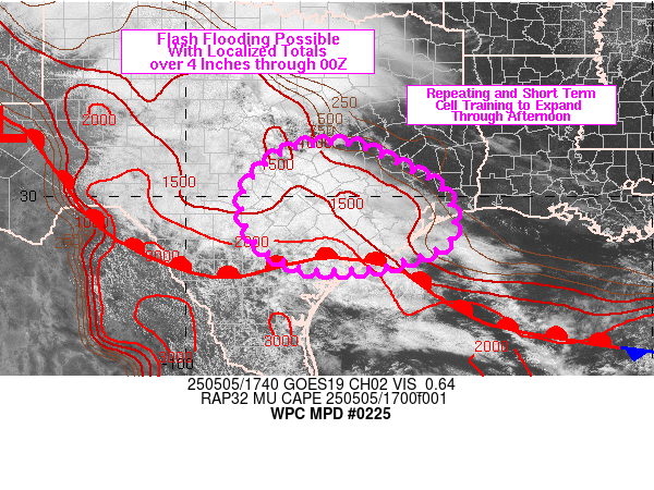
Yeah later this afternoon looks interesting, but also need to watch tuesday and wednesday very closely, most of the short range models indicate potentially training rain bands setting up from houston southward, tuesday- wednesday night with some totals close to a foot of rain in spots, classic setup for flooding in se texas
Area Forecast Discussion
National Weather Service Houston/Galveston TX
1230 PM CDT Mon May 5 2025
...New SYNOPSIS, SHORT TERM, AVIATION...
.SYNOPSIS...
Issued at 1224 PM CDT Mon May 5 2025
An active weather pattern is expected to bring a daily risk of
scattered showers and thunderstorms today, tomorrow, and
Wednesday. Locally heavy rainfall capable of localized flooding is
a concern. In addition, a few strong to severe thunderstorms are
likely. The highest risk of strong to severe storms will be over
our northern counties on Tuesday. However, most of our country
warning area is at risk of experiencing strong thunderstorms each
day. Hail and damaging wind gusts are the primary concern. A few
thunderstorms may be capable of producing a tornado, especially on
Tuesday in our northern counties.
&&
.SHORT TERM...
(Today through Wednesday) Issued at 1224 PM CDT Mon May 5 2025
TODAY:
Mid/upper disturbances in the diffluent flow aloft will interact
with an increasingly moisture rich atmosphere today, resulting in
scattered showers and thunderstorms. A few heavier/stronger
thunderstorms are expected. Locally heavy rainfall, frequent
lightning, and damaging wind gusts are the primary concern.
However, the environment is also favorable for a few thunderstorms
to produce large hail. Gusty east-southeast winds are expected to
continue this afternoon with highs reaching the low 80s. Areas
that experience showers/storms earlier in the afternoon may remain
in the 70s.
TONIGHT:
Lingering thunderstorms possible in the evening. Widely scattered
showers are possible overnight. Inland winds are expected to
become less gusty. Windier conditions expected near the coast.
Conditions will be muggy with lows ranging from the mid 60s in
our northern counties to low 70s at the coast.
TUESDAY:
The vertical wind profile will become highly sheared over
southeast Texas while the presence of a mid/upper low over New
Mexico will help to enhance large scale diffluence and lift aloft.
At the surface, a warm front pushes northward over our area,
enhancing LL convergence and further supporting lift. This will
likely lead to another round of scattered thunderstorms.
Parameters appear to most favor our northern counties for more
widespread thunderstorm activity late Tuesday morning into the
afternoon. Large hail and damaging wind gusts are the primary
concerns. But given the low-level shear profile, we cannot rule
out thunderstorms capable of producing a tornado. Thunderstorms
are likely to result in locally heavier rainfall, possibly up to
4-6 inches in some spots. Thus, a Flood Watch has been issued for
our northern counties for Tuesday.
Worth mentioning that strong thunderstorms will also be possible
across our central and southern counties, even though the threat
is highest across our northern counties.
TUESDAY NIGHT - WEDNESDAY:
The thunderstorm threat is expected to shift southward during this
time frame. Though the environment appears to become somewhat less
favorable for severe weather, we still think locally heavy/strong
thunderstorms are possible Tuesday night into Wednesday. The
environment may become more favorable for thunderstorms training
over the same area. Therefore, we will need to monitor the
potential for localized flash flooding across our southern /
coastal counties.
Current guidance suggest most of the thunderstorms will be
offshore by Wednesday afternoon. But uncertainties remain higher
than normal regarding the timing the exact timing of thunderstorms
Tuesday night into Wednesday.
Self
&&
.LONG TERM...
(Wednesday through Sunday)
Issued at 1224 AM CDT Mon May 5 2025
Though it appears most of the action will have slid up into the
short term section, this anticipated frontal passage will not be a
quick, nor a vigorous one. Indeed, by Wednesday morning, we may
just simply find ourselves in a mess of diffuse remnant frontal
zone and outflow boundaries. This will provide no shortage of
initiation mechanisms, and without a strong frontal passage to
scour out moisture and the unstable airmass, we should expect to
see lingering potential for storms and locally heavy rain through
at least Wednesday morning and into a portion of the afternoon.
Those closer to the coast should likely be on the lookout for the
most significant activity. With onshore flow from the Gulf
continuing, there is a natural convergence axis that should set up
with the southern edge of outflow from earlier storms. Fortunately,
though we`ll still have ample moisture, it does appear from the
ensemble data that the 99th percentile precipitable water should
be off to the east by Wednesday. Which is nice, but 90th
percentile PWATs is still going to allow for at least some
isolated big rainers. WPC keeps a marginal risk of excessive rain
(threat level 1 of 4) from Houston coastward on Thursday, and that
seems pretty a appropriate place to be at this time.
Thursday is a bit of an odd day as we may have some mixed signals
for what to expect convection-wise. At some point, we should
expect the front to be through the area and moving out over the
coastal Gulf waters. Indeed, our deterministic gridded forecast
explicitly does this early to mid morning on Thursday. But if it`s
a bit slower, maybe that keeps better surface convergence (or
perhaps more likely the frontal surface just aloft for some
slightly elevated convection) around a bit deeper into Thursday.
Although, even if winds turn solidly offshore, at least some
guidance is still keeping us on the cyclonic side of the upper
low, and potentially even with a shortwave trough passing overhead
Thursday. With the lower heights keeping things more unstable, and
support to lift from the trough positioning, we could still
squeeze out some showers and isolated storms even if we were to be
in a cleanly post-frontal environment. It certainly wouldn`t make
for impressive rain/storms, but they`d be able to happen
nonetheless.
While I`m certainly trending things downward, it seems prudent to
keep a chance of showers and storms in the forecast on Thursday
for lingering isolated to scattered development. And even Friday,
though it "should" be dry, it`s not a slam dunk. The LREF 500 mb
mean keeps us in a similar situation to Thursday through about
mid-day Friday until we finally get on the side of anti-cyclonic
vorticity advection aloft, and *finally* expectations of fair
weather prevailing for the weekend.
Okay, I`ve written a whole lot about rain potential, but what
about anything else? Well...compared to that, there isn`t really a
whole lot to say. Without a real vigorous frontal passage or a
reinforcing post-frontal cold pool, there just isn`t likely to be
a big shift in temperatures, leaving things fairly seasonable
throughout the term. Yes, Wednesday and Thursday should be a bit
cooler from clouds (Wednesday) and needed evaporation causing a
heat sink (both days), but those effects aren`t likely to be very
significant. After that, we can expect any dip under average we
see to be largely erased. At night, some slightly drier air and
eventual clearing should help overnight lows dip a bit more each
night, but even by Saturday night, we`re still looking at lows in
the upper 50s and lower 60s as dewpoints just don`t get pulled
much lower than that.
Luchs
&&
.AVIATION...
(18Z TAF Issuance)
Issued at 1224 PM CDT Mon May 5 2025
Gusty ESE winds and scattered SHRA/TSRA expected this afternoon.
Winds in the vicinity of any TSRA could exceed 30 knots and become
directionally variable. Risk of TSRA decreases overnight while
flight conditions generally trend MVFR. Areas of IFR possible.
Overnight winds become less gusty, though remain elevated near the
coast. Stronger SE winds expected tomorrow, along with another
chance of scattered SHRA/TSRA. A few stronger thunderstorms
capable of hail are possible.
&&
.MARINE...
Issued at 1224 AM CDT Mon May 5 2025
After another night of light and relatively variable winds, look
for winds to veer southeasterly and increase on Monday as the
next storm system approaches. There is an increasing risk of winds
gusting to 30 knots beginning as early as Monday evening and
continuing through as late as Thursday morning. Rain chances,
winds, and seas continue to increase further on Tuesday. Heavy
thunderstorms are possible on Tuesday into Wednesday. Small Craft
Advisories are likely. Winds shift northerly later in the week,
with drier conditions and lower seas and winds heading into the
weekend.
At the coast, water levels were modestly lower with this past high
tide, but still near High Astronomical Tide levels. As winds
increase into the mid-week, we can look to see water levels
increase back up to around or even a little above 3.0 feet above
MLLW. This would likely put us in a situation where some nuisance
flooding of particularly vulnerable spots are on the table at high
tide, but not yet with enough impacts to prompt a coastal flood
advisory.
Mesoscale Discussion 0695
NWS Storm Prediction Center Norman OK
0118 PM CDT Mon May 05 2025
Areas affected...portions of southeastern Texas
Concerning...Severe potential...Watch possible
Valid 051818Z - 051915Z
Probability of Watch Issuance...40 percent
SUMMARY...An increase in localized severe potential is evident with an intensifying supercell. Severe wind and hail are the main threats, though a tornado could also occur.
DISCUSSION...MRMS mosaic radar imagery depicts a deepening supercell updraft across Lee County, TX, with 40 dBZ echoes exceeding 50 kft and MESH exceeding 1.5 inches. KGRK radar data shows this supercell deviating to the right, toward a surface airmass with mid to upper 70s/60s F temperatures/dewpoints and SBCAPE approaching 1000 J/kg. It is possible that this currently elevated supercell may become surface-based, allowing for this storm to ingest more buoyant parcels and favorable low-level shear (evident via curved low-level hodographs on the EWX and GRK VADs). As such, a severe hail/gust threat may be increasing, and a tornado cannot be ruled out.
URGENT - IMMEDIATE BROADCAST REQUESTED
Severe Thunderstorm Watch Number 225
NWS Storm Prediction Center Norman OK
155 PM CDT Mon May 5 2025
The NWS Storm Prediction Center has issued a
* Severe Thunderstorm Watch for portions of
Southeast Texas
* Effective this Monday afternoon and evening from 155 PM until
800 PM CDT.
* Primary threats include...
Scattered large hail and isolated very large hail events to 2.5
inches in diameter possible
Isolated damaging wind gusts to 70 mph possible
A tornado or two possible
SUMMARY...An intense supercell will likely pose a threat for large
to very large hail up to 1.5 to 2.5 inches in diameter as it tracks
east-southeastward towards the Houston metro area over the next few
hours. Additional robust thunderstorms may also develop through the
rest of the afternoon into early evening.
The severe thunderstorm watch area is approximately along and 50
statute miles east and west of a line from 5 miles northeast of
College Station TX to 40 miles west southwest of Houston TX. For a
complete depiction of the watch see the associated watch outline
update (WOUS64 KWNS WOU5).
PRECAUTIONARY/PREPAREDNESS ACTIONS...
REMEMBER...A Severe Thunderstorm Watch means conditions are
favorable for severe thunderstorms in and close to the watch area.
Persons in these areas should be on the lookout for threatening
weather conditions and listen for later statements and possible
warnings. Severe thunderstorms can and occasionally do produce
tornadoes.
.LONG TERM...
(Wednesday through next Sunday)
Issued at 229 PM CDT Mon May 5 2025
Rain and storm chances continue on Thursday, though it will be on
the downward trend. The cold front is progged to be along the coast
or over the Gulf waters by Thursday morning. However, showers and
thunderstorms will be ongoing early Thursday as an inverted surface
trough (surface convergence) moves through the region. Deterministic
solutions, including NAM, bring highest rainfall totals of up to an
1-inch along the coast. A few weak shortwaves embedded in the flow
aloft will move through on Friday. Despite limited low-level
moisture, we cannot ruled out a few showers, especially in the
afternoon with the peak daytime heating. Surface high pressure
builds in during the weekend, resulting in a drier forecast. Return
flow from the departing high is expected on Monday. This will bring
near seasonal temperatures for the upcoming week.